Bridge Statistics for Hamel, Illinois (IL)
Condition, Traffic, Stress, Structural Evaluation, Project Costs
- National Bridge Inventory (NBI) Statistics
- 18Number of bridges
- 184ft / 56.4mTotal length
- $72,592,000Total costs
- 138,200Total average daily traffic
- 28,316Total average daily truck traffic
- National Bridge Inventory (NBI) Registered Bridges for Hamel
- No street view available for this location
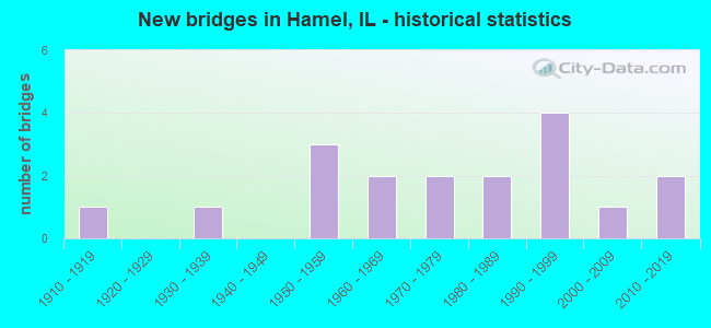
- New bridges - historical statistics
- 11910-1919
- 11930-1939
- 31950-1959
- 21960-1969
- 21970-1979
- 21980-1989
- 41990-1999
- 12000-2009
- 22010-2019

- Reconstructed bridges - Historical Statistics
- 11970-1979
- 11980-1989


- Bridge Condition - Deck
- 30.8%Very good
- 38.5%Good
- 15.4%Satisfactory
- 7.7%Fair
- 7.7%Poor

- Bridge Condition - Superstructure
- 38.5%Very good
- 38.5%Good
- 7.7%Satisfactory
- 7.7%Fair
- 7.7%Poor

- Bridge Condition - Substructure
- 69.2%Very good
- 7.7%Good
- 15.4%Satisfactory
- 7.7%Fair

- Bridge Condition - Channel
- 7.1%Excellent
- 21.4%Very good
- 21.4%Good
- 50.0%Satisfactory

- Bridge Condition - Culverts
- 33.3%Very good
- 66.7%Good
Find on map >> Show street view
Structure Number: 600073, Location: Hamel (Lat: 38.888936, Lng: -89.838297), Route carried "on" structure: State highway 140, Year Built: 1956, Year Reconstructed: 1970, Status: Open, Structure Length: 6.52m (21.39ft), Average Daily Traffic: 8,500 (year 2021), Truck Traffic: 27%, Average Future Daily Traffic: 7,950 (year 2032), Design Load: HS 20, Features Intersected: I-55
Minimum Vertical Clearance: 30+ m (98+ ft), Kilometerpoint: 30.657, Lanes on structure: 4, Lanes under structure: 4, Base Highway Network: Yes, Owner: State Highway Agency, Approaching Roadway Width: 26.2m (86.0ft), Skew: 32 degrees, Material/Design: Steel continuous, Design/Construction: Stringer/Multi-beam, Number Of Spans In Main Unit: 4, Length of Maximum Span: 17.5m (57.4ft), Curb-To-Curb Width: 25.9m (85.0ft), Out-to-Out Width: 26.9m (88.3ft)
Condition: Deck: Good, Superstructure: Good, Substructure: Good, Operating Rating: 76.5 metric tons, Method Used To Determine Operating Rating: Load Factor (LF) rating reported by rating factor (RF) method using MS18 loading, Inventory Rating: 45.7 metric tons, Method Used To Determine Inventory Rating: Load Factor (LF) rating reported by rating factor (RF) method using MS18 loading, Structural Evaluation: Better than present minimum criteria, Deck Geometry: Superior to present desirable criteria, Underclear: Meets minimum limits, Approach Roadway Alignment: Equal to present desirable criteria, Designated Inspection Frequency: Every 24 months, Inspection Date: Febuary 2021, Deck Structure Type: Concrete Cast-file-Place, Wearing Surface/Protective System: Deck Protection: Epoxy Coated Reinforcing
Find on map >> Show street view
Structure Number: 600105, Location: 500' N of IL 140 (Lat: 38.889719, Lng: -89.800731), Route carried "on" structure: State highway 4, Year Built: 1936, Year Reconstructed: 1985, Status: Open, Structure Length: 3.06m (10.04ft), Average Daily Traffic: 3,300 (year 2021), Truck Traffic: 18%, Average Future Daily Traffic: 3,922 (year 2032), Design Load: HS 20, Features Intersected: W Trib to Silver Crk
Minimum Vertical Clearance: 30+ m (98+ ft), Kilometerpoint: 151.628, Lanes on structure: 2, Base Highway Network: Yes, Owner: State Highway Agency, Approaching Roadway Width: 12.2m (40.0ft), Material/Design: Concrete continuous, Design/Construction: Slab, Number Of Spans In Main Unit: 3, Length of Maximum Span: 10.3m (33.8ft), Curb-To-Curb Width: 9.8m (32.2ft), Out-to-Out Width: 10.7m (35.1ft)
Condition: Deck: Very good, Superstructure: Very good, Substructure: Satisfactory, Channel: Satisfactory, Operating Rating: 60.3 metric tons, Method Used To Determine Operating Rating: Load Factor (LF) rating reported by rating factor (RF) method using MS18 loading, Inventory Rating: 36.0 metric tons, Method Used To Determine Inventory Rating: Load Factor (LF) rating reported by rating factor (RF) method using MS18 loading, Structural Evaluation: Equal to present minimum criteria, Deck Geometry: Meets minimum limits, Waterway Adequacy: Superior to present desirable criteria, Approach Roadway Alignment: Equal to present desirable criteria, Designated Inspection Frequency: Every 24 months, Inspection Date: October 2021, Deck Structure Type: Concrete Cast-file-Place, Wearing Surface/Protective System: Deck Protection: Epoxy Coated Reinforcing
Find on map >> Show street view
Structure Number: 60018, Location: 2 M S JCT 140 (Lat: 38.860064, Lng: -89.858339), Route carried "on" structure: County highway , Year Built: 1966, Status: Open, Structure Length: 6.82m (22.38ft), Average Daily Traffic: 350 (year 2021), Truck Traffic: 16%, Average Future Daily Traffic: 345 (year 2032), Design Load: HS 15, Features Intersected: FAI 55, Facility Carried by Structure: TR 177 (MAPLE RD)
Minimum Vertical Clearance: 30+ m (98+ ft), Kilometerpoint: 1.513, Lanes on structure: 2, Lanes under structure: 4, Owner: State Highway Agency, Approaching Roadway Width: 9.1m (29.9ft), Skew: 2 degrees, Material/Design: Steel continuous, Design/Construction: Stringer/Multi-beam, Number Of Spans In Main Unit: 4, Length of Maximum Span: 20.5m (67.3ft), Curb or Sidewalk Widths: Left: 0.6m (2.0ft), Right: 0.6m (2.0ft), Curb-To-Curb Width: 7.3m (24.0ft), Out-to-Out Width: 9.1m (29.9ft)
Condition: Deck: Satisfactory, Superstructure: Good, Substructure: Very good, Operating Rating: 63.2 metric tons, Method Used To Determine Operating Rating: Load Factor (LF) rating reported by rating factor (RF) method using MS18 loading, Inventory Rating: 37.9 metric tons, Method Used To Determine Inventory Rating: Load Factor (LF) rating reported by rating factor (RF) method using MS18 loading, Structural Evaluation: Better than present minimum criteria, Deck Geometry: Somewhat better than minimum adequacy, Underclear: High priority of corrective action, Approach Roadway Alignment: Equal to present desirable criteria, Length Of Structure Improvement: 6.83m (22.41ft), Designated Inspection Frequency: Every 24 months, Inspection Date: Febuary 2022, Bridge Improvement Cost: $470,000, Roadway Improvement Cost: $47,000, Total Project Cost: $517,000, Deck Structure Type: Concrete Cast-file-Place, Wearing Surface/Protective System: Wearing Surface: Other
Find on map >> Show street view
Structure Number: 600258, Location: 0.2mi E of IL 4 (Lat: 38.888692, Lng: -89.798686), Route carried "on" structure: State highway 140, Year Built: 1992, Status: Open, Structure Length: 1.94m (6.36ft), Average Daily Traffic: 2,550 (year 2021), Truck Traffic: 9%, Average Future Daily Traffic: 2,703 (year 2032), Design Load: HS 20, Features Intersected: W Trib to Silver Crk
Minimum Vertical Clearance: 30+ m (98+ ft), Kilometerpoint: 34.085, Lanes on structure: 2, Base Highway Network: Yes, Owner: State Highway Agency, Approaching Roadway Width: 9.8m (32.2ft), Skew: 2 degrees, Material/Design: Steel, Design/Construction: Stringer/Multi-beam, Number Of Spans In Main Unit: 1, Length of Maximum Span: 18.6m (61.0ft), Curb-To-Curb Width: 9.8m (32.2ft), Out-to-Out Width: 10.7m (35.1ft)
Condition: Deck: Very good, Superstructure: Very good, Substructure: Very good, Channel: Very good, Operating Rating: 63.5 metric tons, Method Used To Determine Operating Rating: Load Factor (LF) rating reported by rating factor (RF) method using MS18 loading, Inventory Rating: 38.2 metric tons, Method Used To Determine Inventory Rating: Load Factor (LF) rating reported by rating factor (RF) method using MS18 loading, Structural Evaluation: Equal to present desirable criteria, Deck Geometry: Meets minimum limits, Waterway Adequacy: Superior to present desirable criteria, Approach Roadway Alignment: Equal to present desirable criteria, Designated Inspection Frequency: Every 48 months, Inspection Date: Febuary 2021, Deck Structure Type: Concrete Cast-file-Place, Wearing Surface/Protective System: Deck Protection: Epoxy Coated Reinforcing
Find on map >> Show street view
Structure Number: 600259, Location: 0.4mi E of IL 4 (Lat: 38.888603, Lng: -89.791819), Route carried "on" structure: State highway 140, Year Built: 1992, Status: Open, Structure Length: 3.69m (12.11ft), Average Daily Traffic: 2,550 (year 2021), Truck Traffic: 9%, Average Future Daily Traffic: 2,703 (year 2032), Design Load: HS 20, Features Intersected: Mid Trib Silver Crk
Minimum Vertical Clearance: 30+ m (98+ ft), Kilometerpoint: 34.680, Lanes on structure: 2, Base Highway Network: Yes, Owner: State Highway Agency, Approaching Roadway Width: 9.8m (32.2ft), Skew: 3 degrees, Material/Design: Steel continuous, Design/Construction: Stringer/Multi-beam, Number Of Spans In Main Unit: 2, Length of Maximum Span: 18.0m (59.1ft), Curb-To-Curb Width: 9.8m (32.2ft), Out-to-Out Width: 10.7m (35.1ft)
Condition: Deck: Good, Superstructure: Very good, Substructure: Very good, Channel: Very good, Operating Rating: 73.5 metric tons, Method Used To Determine Operating Rating: Load Factor (LF) rating reported by rating factor (RF) method using MS18 loading, Inventory Rating: 44.1 metric tons, Method Used To Determine Inventory Rating: Load Factor (LF) rating reported by rating factor (RF) method using MS18 loading, Structural Evaluation: Equal to present desirable criteria, Deck Geometry: Meets minimum limits, Waterway Adequacy: Superior to present desirable criteria, Approach Roadway Alignment: Equal to present desirable criteria, Designated Inspection Frequency: Every 48 months, Inspection Date: Febuary 2021, Deck Structure Type: Concrete Cast-file-Place, Wearing Surface/Protective System: Deck Protection: Epoxy Coated Reinforcing
Find on map >> Show street view
Structure Number: 60026, Location: 0.5mi E of IL 4 (Lat: 38.888592, Lng: -89.790892), Route carried "on" structure: State highway 140, Year Built: 1992, Status: Open, Structure Length: 4.91m (16.11ft), Average Daily Traffic: 2,550 (year 2021), Truck Traffic: 9%, Average Future Daily Traffic: 2,703 (year 2032), Design Load: HS 20, Features Intersected: Silver Creek
Minimum Vertical Clearance: 30+ m (98+ ft), Kilometerpoint: 34.761, Lanes on structure: 2, Base Highway Network: Yes, Owner: State Highway Agency, Approaching Roadway Width: 9.8m (32.2ft), Material/Design: Steel continuous, Design/Construction: Stringer/Multi-beam, Number Of Spans In Main Unit: 3, Length of Maximum Span: 18.6m (61.0ft), Curb-To-Curb Width: 9.8m (32.2ft), Out-to-Out Width: 10.7m (35.1ft)
Condition: Deck: Good, Superstructure: Good, Substructure: Very good, Channel: Good, Operating Rating: 79.1 metric tons, Method Used To Determine Operating Rating: Load Factor (LF) rating reported by rating factor (RF) method using MS18 loading, Inventory Rating: 47.3 metric tons, Method Used To Determine Inventory Rating: Load Factor (LF) rating reported by rating factor (RF) method using MS18 loading, Structural Evaluation: Better than present minimum criteria, Deck Geometry: Meets minimum limits, Waterway Adequacy: Equal to present desirable criteria, Approach Roadway Alignment: Equal to present desirable criteria, Designated Inspection Frequency: Every 48 months, Inspection Date: Febuary 2021, Deck Structure Type: Concrete Cast-file-Place, Wearing Surface/Protective System: Deck Protection: Epoxy Coated Reinforcing
Find on map >> Show street view
Structure Number: 600334, Location: 1.9MI S OF IL 140 (Lat: 38.860364, Lng: -89.801000), Route carried "on" structure: State highway 4, Year Built: 2006, Status: Open, Structure Length: 10.00m (32.81ft), Average Daily Traffic: 3,650 (year 2021), Truck Traffic: 16%, Average Future Daily Traffic: 3,975 (year 2032), Design Load: HS 25 or greater, Features Intersected: SILVER CREEK
Minimum Vertical Clearance: 30+ m (98+ ft), Kilometerpoint: 148.377, Lanes on structure: 2, Base Highway Network: Yes, Owner: State Highway Agency, Approaching Roadway Width: 7.3m (24.0ft), Material/Design: Steel continuous, Design/Construction: Stringer/Multi-beam, Number Of Spans In Main Unit: 5, Length of Maximum Span: 22.6m (74.1ft), Curb-To-Curb Width: 11.0m (36.1ft), Out-to-Out Width: 11.9m (39.0ft)
Condition: Deck: Very good, Superstructure: Very good, Substructure: Very good, Channel: Good, Operating Rating: 74.5 metric tons, Method Used To Determine Operating Rating: Load and Resistance Factor Rating (LRFR) rating reported by rating factor(RF) method using HL-93 loadings, Inventory Rating: 57.3 metric tons, Method Used To Determine Inventory Rating: Load and Resistance Factor Rating (LRFR) rating reported by rating factor(RF) method using HL-93 loadings, Structural Evaluation: Equal to present desirable criteria, Deck Geometry: Somewhat better than minimum adequacy, Waterway Adequacy: Superior to present desirable criteria, Approach Roadway Alignment: Equal to present desirable criteria, Designated Inspection Frequency: Every 48 months, Inspection Date: October 2021, Deck Structure Type: Concrete Cast-file-Place, Wearing Surface/Protective System: Deck Protection: Epoxy Coated Reinforcing
Find on map >> Show street view
Structure Number: 60202, Location: 1.68 S ILL 140 (Lat: 38.867511, Lng: -89.853089), Route carried "on" structure: Interstate 55, Year Built: 1955, Status: Open, Structure Length: 0.83m (2.72ft), Average Daily Traffic: 38,600 (year 2021), Truck Traffic: 20%, Average Future Daily Traffic: 28,302 (year 2032), Design Load: HS 20, Features Intersected: TRIB TO SILVER CREEK
Minimum Vertical Clearance: 30+ m (98+ ft), Kilometerpoint: 44.916, Lanes on structure: 4, Base Highway Network: Yes, Owner: State Highway Agency, Approaching Roadway Width: 32.9m (107.9ft), Skew: 13 degrees, Material/Design: Concrete continuous, Design/Construction: Culvert, Number Of Spans In Main Unit: 2, Length of Maximum Span: 3.6m (11.8ft)
Condition: Channel: Satisfactory, Culverts: Good, Operating Rating: 97.2 metric tons, Method Used To Determine Operating Rating: Load Factor (LF) rating reported by rating factor (RF) method using MS18 loading, Inventory Rating: 97.2 metric tons, Method Used To Determine Inventory Rating: Load Factor (LF) rating reported by rating factor (RF) method using MS18 loading, Structural Evaluation: Better than present minimum criteria, Waterway Adequacy: Equal to present desirable criteria, Approach Roadway Alignment: Equal to present desirable criteria, Designated Inspection Frequency: Every 24 months, Inspection Date: Febuary 2022
Find on map >> Show street view
Structure Number: 602052, Location: Just S of Hamel CL (Lat: 38.883989, Lng: -89.850497), Route carried "on" structure: State highway 157, Year Built: 2019, Status: Open, Structure Length: 0.70m (2.30ft), Average Daily Traffic: 2,500 (year 2021), Truck Traffic: 5%, Average Future Daily Traffic: 5,088 (year 2032), Design Load: HS 25 or greater, Features Intersected: Trib to Silver Creek
Minimum Vertical Clearance: 30+ m (98+ ft), Kilometerpoint: 56.358, Lanes on structure: 2, Owner: State Highway Agency, Approaching Roadway Width: 9.8m (32.2ft), Skew: 1 degrees, Material/Design: Concrete continuous, Design/Construction: Culvert, Number Of Spans In Main Unit: 2, Length of Maximum Span: 3.2m (10.5ft), Curb-To-Curb Width: 9.8m (32.2ft)
Condition: Channel: Very good, Culverts: Very good, Operating Rating: 71.0 metric tons, Method Used To Determine Operating Rating: Load and Resistance Factor Rating (LRFR) rating reported by rating factor(RF) method using HL-93 loadings, Inventory Rating: 54.8 metric tons, Method Used To Determine Inventory Rating: Load and Resistance Factor Rating (LRFR) rating reported by rating factor(RF) method using HL-93 loadings, Structural Evaluation: Equal to present desirable criteria, Deck Geometry: Meets minimum limits, Waterway Adequacy: Superior to present desirable criteria, Approach Roadway Alignment: Equal to present desirable criteria, Designated Inspection Frequency: Every 48 months, Inspection Date: June 2021
Find on map >> Show street view
Structure Number: 603134, Location: 2.0 MI S HAMEL (Lat: 38.855033, Lng: -89.843750), Route carried "on" structure: County highway , Year Built: 1916, Status: Open, Structure Length: 0.76m (2.49ft), Average Daily Traffic: 200 (year 2021), Truck Traffic: 15%, Average Future Daily Traffic: 159 (year 2032), Features Intersected: TRIB TO SILVER CK, Facility Carried by Structure: COLUMBIA RD/TR 250
Minimum Vertical Clearance: 30+ m (98+ ft), Kilometerpoint: 0.563, Lanes on structure: 1, Owner: Town or Township Highway Agency, Approaching Roadway Width: 3.7m (12.1ft), Material/Design: Concrete, Number Of Spans In Main Unit: 1, Length of Maximum Span: 7.0m (23.0ft), Curb-To-Curb Width: 4.9m (16.1ft), Out-to-Out Width: 5.3m (17.4ft)
Condition: Deck: Fair, Superstructure: Fair, Substructure: Satisfactory, Channel: Satisfactory, Operating Rating: 40.5 metric tons, Method Used To Determine Operating Rating: Field evaluation and documented engineering judgment, Inventory Rating: 24.3 metric tons, Method Used To Determine Inventory Rating: Field evaluation and documented engineering judgment, Structural Evaluation: Somewhat better than minimum adequacy, Deck Geometry: High priority of replacement, Waterway Adequacy: Equal to present minimum criteria, Approach Roadway Alignment: Better than present minimum criteria, Length Of Structure Improvement: 0.76m (2.49ft), Designated Inspection Frequency: Every 24 months, Inspection Date: October 2021, Bridge Improvement Cost: $64,875,000, Roadway Improvement Cost: $7,200,000, Total Project Cost: $72,075,000, Deck Structure Type: Concrete Cast-file-Place, Wearing Surface/Protective System: Wearing Surface: Gravel
Find on map >> Show street view
Structure Number: 603204, Location: 2.5 MI NW ALHAMBRA (Lat: 38.903128, Lng: -89.791850), Route carried "on" structure: County highway , Year Built: 1971, Status: Open, Structure Length: 1.28m (4.20ft), Average Daily Traffic: 100 (year 2021), Truck Traffic: 7%, Average Future Daily Traffic: 53 (year 2032), Design Load: HS 20, Features Intersected: TRIB TO SILVER CR, Facility Carried by Structure: GORENZ DR/TR 143
Minimum Vertical Clearance: 30+ m (98+ ft), Kilometerpoint: 1.947, Lanes on structure: 1, Owner: Town or Township Highway Agency, Approaching Roadway Width: 4.0m (13.1ft), Material/Design: Prestressed concrete, Design/Construction: Box Beam or Girders - Multiple, Number Of Spans In Main Unit: 1, Length of Maximum Span: 12.2m (40.0ft), Curb-To-Curb Width: 5.9m (19.4ft), Out-to-Out Width: 6.5m (21.3ft)
Condition: Deck: Poor, Superstructure: Poor, Substructure: Very good, Channel: Satisfactory, Operating Rating: 56.4 metric tons, Method Used To Determine Operating Rating: Load Factor (LF) rating reported by rating factor (RF) method using MS18 loading, Inventory Rating: 33.7 metric tons, Method Used To Determine Inventory Rating: Load Factor (LF) rating reported by rating factor (RF) method using MS18 loading, Structural Evaluation: Meets minimum limits, Deck Geometry: Meets minimum limits, Waterway Adequacy: Equal to present desirable criteria, Approach Roadway Alignment: Equal to present minimum criteria, Designated Inspection Frequency: Every 24 months, Inspection Date: November 2021, Deck Structure Type: Concrete Precast Panels
Find on map >> Show street view
Structure Number: 603214, Location: 1.5MI S HAMEL (Lat: 38.859964, Lng: -89.847981), Route carried "on" structure: County highway , Year Built: 1973, Status: Open, Structure Length: 1.16m (3.81ft), Average Daily Traffic: 150 (year 2021), Truck Traffic: 14%, Average Future Daily Traffic: 265 (year 2032), Design Load: HS 20, Features Intersected: TR1B TO SILVER CK, Facility Carried by Structure: MAPLE RD/ TR 177
Minimum Vertical Clearance: 30+ m (98+ ft), Kilometerpoint: 2.462, Lanes on structure: 2, Owner: Town or Township Highway Agency, Approaching Roadway Width: 5.5m (18.0ft), Skew: 2 degrees, Material/Design: Steel, Design/Construction: Culvert, Number Of Spans In Main Unit: 2, Length of Maximum Span: 5.3m (17.4ft)
Condition: Channel: Satisfactory, Culverts: Good, Operating Rating: 40.8 metric tons, Method Used To Determine Operating Rating: Load Factor (LF) rating reported by rating factor (RF) method using MS18 loading, Inventory Rating: 33.7 metric tons, Method Used To Determine Inventory Rating: Load Factor (LF) rating reported by rating factor (RF) method using MS18 loading, Structural Evaluation: Better than present minimum criteria, Waterway Adequacy: Equal to present minimum criteria, Approach Roadway Alignment: Equal to present desirable criteria, Designated Inspection Frequency: Every 24 months, Inspection Date: October 2021
Find on map >> Show street view
Structure Number: 603252, Location: 8.8 MI W GRANTFORK (Lat: 38.830572, Lng: -89.832533), Route carried "on" structure: County highway , Year Built: 1983, Status: Open, Structure Length: 9.08m (29.79ft), Average Daily Traffic: 725 (year 2021), Truck Traffic: 7%, Average Future Daily Traffic: 795 (year 2032), Design Load: HS 20, Features Intersected: SILVER CK, Facility Carried by Structure: FAS 766/ FRUIT RD.
Minimum Vertical Clearance: 30+ m (98+ ft), Kilometerpoint: 6.920, Lanes on structure: 2, Owner: County Highway Agency, Approaching Roadway Width: 8.5m (27.9ft), Material/Design: Prestressed concrete, Design/Construction: Box Beam or Girders - Multiple, Number Of Spans In Main Unit: 6, Length of Maximum Span: 15.2m (49.9ft), Curb-To-Curb Width: 9.1m (29.9ft), Out-to-Out Width: 9.1m (29.9ft)
Condition: Deck: Satisfactory, Superstructure: Satisfactory, Substructure: Fair, Channel: Good, Operating Rating: 55.7 metric tons, Method Used To Determine Operating Rating: Load Factor (LF) rating reported by rating factor (RF) method using MS18 loading, Inventory Rating: 33.4 metric tons, Method Used To Determine Inventory Rating: Load Factor (LF) rating reported by rating factor (RF) method using MS18 loading, Structural Evaluation: Somewhat better than minimum adequacy, Deck Geometry: Equal to present minimum criteria, Waterway Adequacy: Equal to present desirable criteria, Approach Roadway Alignment: Equal to present desirable criteria, Designated Inspection Frequency: Every 24 months, Inspection Date: March 2020, Deck Structure Type: Concrete Precast Panels, Wearing Surface/Protective System: Wearing Surface: Bituminous, Membrane: Built-up
Find on map >> Show street view
Structure Number: 603275, Location: 1 MILE SE OF HAMEL (Lat: 38.874303, Lng: -89.818453), Route carried "on" structure: County highway , Year Built: 1987, Status: Open, Structure Length: 1.89m (6.20ft), Average Daily Traffic: 125 (year 2016), Truck Traffic: 14%, Average Future Daily Traffic: 53 (year 2032), Design Load: HS 20, Features Intersected: TRIB. TO SILVER CRK., Facility Carried by Structure: TR157
Minimum Vertical Clearance: 30.40m (99.74ft), Kilometerpoint: 1.352, Lanes on structure: 2, Owner: Town or Township Highway Agency, Approaching Roadway Width: 6.4m (21.0ft), Skew: 2 degrees, Material/Design: Prestressed concrete, Design/Construction: Box Beam or Girders - Multiple, Number Of Spans In Main Unit: 1, Length of Maximum Span: 18.0m (59.1ft), Curb-To-Curb Width: 8.7m (28.5ft), Out-to-Out Width: 8.7m (28.5ft)
Condition: Deck: Good, Superstructure: Good, Substructure: Very good, Channel: Satisfactory, Operating Rating: 44.4 metric tons, Method Used To Determine Operating Rating: Assigned rating based on Load Factor Design (LFD) reported by rating factor (RF) using MS18 loading, Inventory Rating: 32.4 metric tons, Method Used To Determine Inventory Rating: Assigned rating based on Load Factor Design (LFD) reported by rating factor (RF) using MS18 loading, Structural Evaluation: Better than present minimum criteria, Deck Geometry: Equal to present minimum criteria, Waterway Adequacy: Equal to present desirable criteria, Approach Roadway Alignment: Equal to present desirable criteria, Designated Inspection Frequency: Every 48 months, Inspection Date: October 2021, Deck Structure Type: Concrete Precast Panels, Wearing Surface/Protective System: Wearing Surface: Gravel
Find on map >> Show street view
Structure Number: 603321, Location: 2.5MI S OF HAMEL (Lat: 38.845250, Lng: -89.839644), Route carried "on" structure: County highway , Year Built: 1996, Status: Open, Structure Length: 2.33m (7.64ft), Average Daily Traffic: 50 (year 2021), Truck Traffic: 10%, Average Future Daily Traffic: 53 (year 2032), Design Load: HS 20, Features Intersected: TRIB TO SILVER CREEK, Facility Carried by Structure: TWIN HILL LN/TR 19
Minimum Vertical Clearance: 30+ m (98+ ft), Kilometerpoint: 0.370, Lanes on structure: 2, Owner: Town or Township Highway Agency, Approaching Roadway Width: 6.7m (22.0ft), Material/Design: Prestressed concrete, Design/Construction: Box Beam or Girders - Multiple, Number Of Spans In Main Unit: 3, Length of Maximum Span: 7.6m (24.9ft), Curb-To-Curb Width: 8.6m (28.2ft), Out-to-Out Width: 8.6m (28.2ft)
Condition: Deck: Good, Superstructure: Good, Substructure: Very good, Channel: Satisfactory, Operating Rating: 44.1 metric tons, Method Used To Determine Operating Rating: Assigned rating based on Load Factor Design (LFD) reported by rating factor (RF) using MS18 loading, Inventory Rating: 32.4 metric tons, Method Used To Determine Inventory Rating: Assigned rating based on Load Factor Design (LFD) reported by rating factor (RF) using MS18 loading, Structural Evaluation: Better than present minimum criteria, Deck Geometry: Better than present minimum criteria, Waterway Adequacy: Equal to present desirable criteria, Approach Roadway Alignment: Equal to present desirable criteria, Designated Inspection Frequency: Every 48 months, Inspection Date: October 2021, Deck Structure Type: Concrete Precast Panels, Wearing Surface/Protective System: Wearing Surface: Bituminous, Membrane: Built-up
Find on map >> Show street view
Structure Number: 603352, Location: 2.2 MI S HAMEL (Lat: 38.848136, Lng: -89.857869), Route carried "on" structure: County highway , Year Built: 2011, Status: Open, Structure Length: 1.44m (4.72ft), Average Daily Traffic: 200 (year 2021), Truck Traffic: 15%, Average Future Daily Traffic: 265 (year 2032), Design Load: HS 25 or greater, Features Intersected: TRIB SILVER CR, Facility Carried by Structure: TR 238A STAUNTON R
Minimum Vertical Clearance: 30+ m (98+ ft), Kilometerpoint: 1.352, Lanes on structure: 2, Owner: Town or Township Highway Agency, Approaching Roadway Width: 7.0m (23.0ft), Skew: 3 degrees, Material/Design: Prestressed concrete, Design/Construction: Box Beam or Girders - Multiple, Number Of Spans In Main Unit: 1, Length of Maximum Span: 13.5m (44.3ft), Curb-To-Curb Width: 9.3m (30.5ft), Out-to-Out Width: 9.3m (30.5ft)
Condition: Deck: Very good, Superstructure: Very good, Substructure: Very good, Channel: Excellent, Operating Rating: 44.1 metric tons, Method Used To Determine Operating Rating: Assigned rating based on Load Factor Design (LFD) reported by rating factor (RF) using MS18 loading, Inventory Rating: 32.4 metric tons, Method Used To Determine Inventory Rating: Assigned rating based on Load Factor Design (LFD) reported by rating factor (RF) using MS18 loading, Structural Evaluation: Equal to present desirable criteria, Deck Geometry: Equal to present minimum criteria, Waterway Adequacy: Superior to present desirable criteria, Approach Roadway Alignment: Better than present minimum criteria, Designated Inspection Frequency: Every 48 months, Inspection Date: October 2021, Deck Structure Type: Concrete Precast Panels, Wearing Surface/Protective System: Wearing Surface: Bituminous, Membrane: Built-up
Find on map >> Show street view
Structure Number: 600073, Location: Hamel (Lat: 38.888936, Lng: -89.838297), Route carried "under" structure: Interstate 55, Year Built: 1956, Structure Length: 0. m, Average Daily Traffic: 33,500 (year 2021), Truck Traffic: 25%, Features Intersected: I-55, Facility Carried by Structure: IL 140
Minimum Vertical Clearance: 5.26m (17.26ft), Kilometerpoint: 47.619, Lanes on structure: 4, Lanes under structure: 4, Material/Design: Steel continuous, Design/Construction: Stringer/Multi-beam, Length of Maximum Span: 17.5m (57.4ft)
Find on map >> Show street view
Structure Number: 60018, Location: 2 M S JCT 140 (Lat: 38.860064, Lng: -89.858339), Route carried "under" structure: Interstate 55, Year Built: 1966, Structure Length: 0. m, Average Daily Traffic: 38,600 (year 2021), Truck Traffic: 20%, Features Intersected: FAI 55, Facility Carried by Structure: TR 177 (MAPLE RD)
Minimum Vertical Clearance: 5.16m (16.93ft), Kilometerpoint: 43.950, Lanes on structure: 2, Lanes under structure: 4, Material/Design: Steel continuous, Design/Construction: Stringer/Multi-beam, Length of Maximum Span: 20.5m (67.3ft)