Bridge Statistics for Hallam, Pennsylvania (PA)
Condition, Traffic, Stress, Structural Evaluation, Project Costs
- National Bridge Inventory (NBI) Statistics
- 19Number of bridges
- 112ft / 34.2mTotal length
- $3,266,000Total costs
- 142,482Total average daily traffic
- 17,464Total average daily truck traffic
- National Bridge Inventory (NBI) Registered Bridges for Hallam
- No street view available for this location
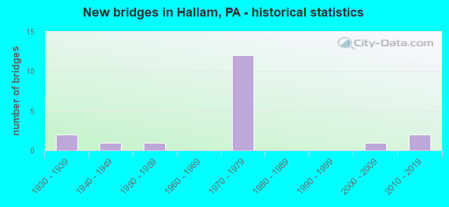
- New bridges - historical statistics
- 21930-1939
- 11940-1949
- 11950-1959
- 121970-1979
- 12000-2009
- 22010-2019

- Reconstructed bridges - Historical Statistics
- 11990-1999
- 12000-2009


- Bridge Condition - Deck
- 36.4%Very good
- 36.4%Good
- 9.1%Satisfactory
- 18.2%Fair

- Bridge Condition - Superstructure
- 36.4%Very good
- 18.2%Good
- 9.1%Satisfactory
- 36.4%Fair

- Bridge Condition - Substructure
- 27.3%Very good
- 9.1%Good
- 18.2%Satisfactory
- 45.5%Fair

- Bridge Condition - Channel
- 11.1%Very good
- 22.2%Good
- 22.2%Satisfactory
- 44.4%Fair

- Bridge Condition - Culverts
- 50.0%Satisfactory
- 50.0%Fair
Find on map >> Show street view
Structure Number: 3738, Location: .2 MI N OF LR128 (Lat: 40.006111, Lng: -76.614661), Route carried "on" structure: US 30, Year Built: 1970, Status: Open, Structure Length: 5.15m (16.90ft), Average Daily Traffic: 21,964 (year 2020), Truck Traffic: 16%, Average Future Daily Traffic: 29,092 (year 2032), Design Load: HS 20, Features Intersected: SR 1014
Minimum Vertical Clearance: 30+ m (98+ ft), Kilometerpoint: 36.053, Lanes on structure: 2, Lanes under structure: 8, Base Highway Network: Yes, Owner: State Highway Agency, Approaching Roadway Width: 12.8m (42.0ft), Skew: 11 degrees, Material/Design: Steel, Design/Construction: Stringer/Multi-beam, Number Of Spans In Main Unit: 1, Length of Maximum Span: 50.3m (165.0ft), Curb or Sidewalk Widths: Left: 0.2m (0.7ft), Right: 0.2m (0.7ft), Curb-To-Curb Width: 12.0m (39.4ft), Out-to-Out Width: 13.2m (43.3ft)
Condition: Deck: Very good, Superstructure: Good, Substructure: Fair, Operating Rating: 73.5 metric tons, Method Used To Determine Operating Rating: Load Factor (LF), Inventory Rating: 44.5 metric tons, Method Used To Determine Inventory Rating: Load Factor (LF), Structural Evaluation: Somewhat better than minimum adequacy, Deck Geometry: Equal to present minimum criteria, Underclear: Better than present minimum criteria, Approach Roadway Alignment: Equal to present desirable criteria, Length Of Structure Improvement: 6.10m (20.01ft), Designated Inspection Frequency: Every 24 months, Inspection Date: August 2021, Deck Structure Type: Concrete Cast-file-Place, Wearing Surface/Protective System: Wearing Surface: Latex Concrete
Find on map >> Show street view
Structure Number: 37382, Location: .2 MI N OF LR128 (Lat: 40.005892, Lng: -76.617406), Route carried "on" structure: US 30, Year Built: 1970, Year Reconstructed: 2003, Status: Open, Structure Length: 5.15m (16.90ft), Average Daily Traffic: 21,270 (year 2020), Truck Traffic: 17%, Average Future Daily Traffic: 29,139 (year 2032), Design Load: HS 20, Features Intersected: SR 1014
Minimum Vertical Clearance: 30+ m (98+ ft), Kilometerpoint: 36.102, Lanes on structure: 2, Lanes under structure: 8, Base Highway Network: Yes, Owner: State Highway Agency, Approaching Roadway Width: 12.8m (42.0ft), Skew: 11 degrees, Material/Design: Steel, Design/Construction: Stringer/Multi-beam, Number Of Spans In Main Unit: 1, Length of Maximum Span: 50.3m (165.0ft), Curb or Sidewalk Widths: Left: 0.2m (0.7ft), Right: 0.2m (0.7ft), Curb-To-Curb Width: 12.0m (39.4ft), Out-to-Out Width: 13.2m (43.3ft)
Condition: Deck: Good, Superstructure: Good, Substructure: Fair, Operating Rating: 73.5 metric tons, Method Used To Determine Operating Rating: Load Factor (LF), Inventory Rating: 44.5 metric tons, Method Used To Determine Inventory Rating: Load Factor (LF), Structural Evaluation: Somewhat better than minimum adequacy, Deck Geometry: Equal to present minimum criteria, Underclear: Equal to present minimum criteria, Approach Roadway Alignment: Equal to present desirable criteria, Length Of Structure Improvement: 6.10m (20.01ft), Designated Inspection Frequency: Every 24 months, Inspection Date: August 2021, Deck Structure Type: Concrete Cast-file-Place, Wearing Surface/Protective System: Wearing Surface: Monolithic Concrete
Find on map >> Show street view
Structure Number: 37383, Location: 0.5 MI NE OF HALLAM (Lat: 40.014278, Lng: -76.592556), Route carried "on" structure: US 30, Year Built: 1971, Status: Open, Structure Length: 3.81m (12.50ft), Average Daily Traffic: 21,964 (year 2020), Truck Traffic: 16%, Average Future Daily Traffic: 29,092 (year 2032), Design Load: HS 20, Features Intersected: SR 1037 accomac rd.
Minimum Vertical Clearance: 30+ m (98+ ft), Kilometerpoint: 38.415, Lanes on structure: 2, Lanes under structure: 2, Base Highway Network: Yes, Owner: State Highway Agency, Approaching Roadway Width: 11.6m (38.1ft), Skew: 12 degrees, Material/Design: Prestressed concrete, Design/Construction: Box Beam or Girders - Single/Spread, Number Of Spans In Main Unit: 3, Length of Maximum Span: 18.0m (59.1ft), Curb or Sidewalk Widths: Left: 0.2m (0.7ft), Right: 0.2m (0.7ft), Curb-To-Curb Width: 12.0m (39.4ft), Out-to-Out Width: 13.2m (43.3ft)
Condition: Deck: Satisfactory, Superstructure: Fair, Substructure: Fair, Operating Rating: 52.6 metric tons, Method Used To Determine Operating Rating: Load Factor (LF), Inventory Rating: 31.8 metric tons, Method Used To Determine Inventory Rating: Load Factor (LF), Structural Evaluation: Somewhat better than minimum adequacy, Deck Geometry: Better than present minimum criteria, Underclear: Equal to present minimum criteria, Approach Roadway Alignment: Equal to present desirable criteria, Length Of Structure Improvement: 4.80m (15.75ft), Designated Inspection Frequency: Every 24 months, Inspection Date: September 2021, Bridge Improvement Cost: $47,000, Roadway Improvement Cost: $139,000, Total Project Cost: $638,000, Deck Structure Type: Concrete Cast-file-Place, Wearing Surface/Protective System: Wearing Surface: Latex Concrete
Find on map >> Show street view
Structure Number: 37384, Location: .3 MI N OF LR128 (Lat: 40.014556, Lng: -76.592611), Route carried "on" structure: US 30, Year Built: 1971, Status: Open, Structure Length: 3.90m (12.80ft), Average Daily Traffic: 21,270 (year 2020), Truck Traffic: 17%, Average Future Daily Traffic: 29,139 (year 2032), Design Load: HS 20, Features Intersected: SR 1037
Minimum Vertical Clearance: 30+ m (98+ ft), Kilometerpoint: 38.457, Lanes on structure: 2, Lanes under structure: 2, Base Highway Network: Yes, Owner: State Highway Agency, Approaching Roadway Width: 11.6m (38.1ft), Skew: 12 degrees, Material/Design: Prestressed concrete, Design/Construction: Box Beam or Girders - Single/Spread, Number Of Spans In Main Unit: 3, Length of Maximum Span: 18.9m (62.0ft), Curb or Sidewalk Widths: Left: 0.2m (0.7ft), Right: 0.2m (0.7ft), Curb-To-Curb Width: 12.0m (39.4ft), Out-to-Out Width: 13.2m (43.3ft)
Condition: Deck: Good, Superstructure: Fair, Substructure: Fair, Operating Rating: 52.6 metric tons, Method Used To Determine Operating Rating: Load Factor (LF), Inventory Rating: 31.8 metric tons, Method Used To Determine Inventory Rating: Load Factor (LF), Structural Evaluation: Somewhat better than minimum adequacy, Deck Geometry: Better than present minimum criteria, Underclear: Equal to present minimum criteria, Approach Roadway Alignment: Equal to present desirable criteria, Length Of Structure Improvement: 4.70m (15.42ft), Designated Inspection Frequency: Every 24 months, Inspection Date: September 2021, Bridge Improvement Cost: $30,000, Roadway Improvement Cost: $87,000, Total Project Cost: $399,000, Deck Structure Type: Concrete Cast-file-Place, Wearing Surface/Protective System: Wearing Surface: Latex Concrete
Find on map >> Show street view
Structure Number: 37598, Location: .8 MI. WEST OF HALLAM (Lat: 40.001639, Lng: -76.618250), Route carried "on" structure: State highway 462, Year Built: 1934, Status: Open, Structure Length: 1.01m (3.31ft), Average Daily Traffic: 12,258 (year 2020), Truck Traffic: 4%, Average Future Daily Traffic: 16,923 (year 2032), Design Load: H 20, Features Intersected: KREUTZ CREEK
Minimum Vertical Clearance: 30+ m (98+ ft), Kilometerpoint: 12.641, Lanes on structure: 2, Owner: State Highway Agency, Approaching Roadway Width: 15.2m (49.9ft), Material/Design: Concrete, Design/Construction: Tee Beam, Number Of Spans In Main Unit: 1, Length of Maximum Span: 9.1m (29.9ft), Curb or Sidewalk Widths: Left: 0.2m (0.7ft), Right: 0.2m (0.7ft), Curb-To-Curb Width: 15.2m (49.9ft), Out-to-Out Width: 16.0m (52.5ft)
Condition: Deck: Fair, Superstructure: Fair, Substructure: Satisfactory, Channel: Fair, Operating Rating: 49.0 metric tons, Method Used To Determine Operating Rating: Load Factor (LF), Inventory Rating: 29.0 metric tons, Method Used To Determine Inventory Rating: Load Factor (LF), Structural Evaluation: Somewhat better than minimum adequacy, Deck Geometry: Superior to present desirable criteria, Waterway Adequacy: Equal to present minimum criteria, Approach Roadway Alignment: Equal to present desirable criteria, Length Of Structure Improvement: 1.60m (5.25ft), Designated Inspection Frequency: Every 24 months, Inspection Date: September 2021, Bridge Improvement Cost: $72,000, Roadway Improvement Cost: $212,000, Total Project Cost: $972,000, Deck Structure Type: Concrete Cast-file-Place, Wearing Surface/Protective System: Wearing Surface: Bituminous, Membrane: Preformed Fabric
Find on map >> Show street view
Structure Number: 37667, Location: N.OF U.S. 30 (Lat: 40.010889, Lng: -76.617667), Route carried "on" structure: State highway , Year Built: 1970, Status: Open, Structure Length: 0.88m (2.89ft), Average Daily Traffic: 1,091 (year 2022), Truck Traffic: 10%, Average Future Daily Traffic: 1,405 (year 2032), Design Load: HS 20, Features Intersected: KREUTZ CREEK, Facility Carried by Structure: SR 1014
Minimum Vertical Clearance: 30+ m (98+ ft), Kilometerpoint: 10.046, Lanes on structure: 2, Owner: State Highway Agency, Approaching Roadway Width: 13.4m (44.0ft), Skew: 4 degrees, Material/Design: Concrete, Design/Construction: Culvert, Number Of Spans In Main Unit: 1, Length of Maximum Span: 7.6m (24.9ft), Curb-To-Curb Width: 13.7m (44.9ft), Out-to-Out Width: 14.7m (48.2ft)
Condition: Channel: Satisfactory, Culverts: Fair, Operating Rating: 49.0 metric tons, Method Used To Determine Operating Rating: Field evaluation and documented engineering judgment, Inventory Rating: 32.7 metric tons, Method Used To Determine Inventory Rating: Field evaluation and documented engineering judgment, Structural Evaluation: Somewhat better than minimum adequacy, Deck Geometry: Superior to present desirable criteria, Waterway Adequacy: Equal to present minimum criteria, Approach Roadway Alignment: Equal to present desirable criteria, Length Of Structure Improvement: 1.60m (5.25ft), Designated Inspection Frequency: Every 24 months, Inspection Date: September 2021, Wearing Surface/Protective System: Wearing Surface: Monolithic Concrete
Find on map >> Show street view
Structure Number: 37669, Location: 1.2 MI.W. OF HALLAM (Lat: 40.002981, Lng: -76.616889), Route carried "on" structure: State highway , Year Built: 1970, Status: Open, Structure Length: 0.91m (2.99ft), Average Daily Traffic: 12,275 (year 2022), Truck Traffic: 6%, Average Future Daily Traffic: 14,419 (year 2032), Design Load: HS 20, Features Intersected: KREUTZ CREEK, Facility Carried by Structure: SR 1014
Minimum Vertical Clearance: 30+ m (98+ ft), Kilometerpoint: 10.482, Lanes on structure: 4, Owner: State Highway Agency, Approaching Roadway Width: 24.4m (80.1ft), Skew: 23 degrees, Material/Design: Concrete, Design/Construction: Culvert, Number Of Spans In Main Unit: 1, Length of Maximum Span: 8.2m (26.9ft)
Condition: Channel: Good, Culverts: Satisfactory, Operating Rating: 49.0 metric tons, Method Used To Determine Operating Rating: Field evaluation and documented engineering judgment, Inventory Rating: 32.7 metric tons, Method Used To Determine Inventory Rating: Field evaluation and documented engineering judgment, Structural Evaluation: Equal to present minimum criteria, Waterway Adequacy: Superior to present desirable criteria, Approach Roadway Alignment: Equal to present desirable criteria, Length Of Structure Improvement: 1.40m (4.59ft), Designated Inspection Frequency: Every 24 months, Inspection Date: August 2021
Find on map >> Show street view
Structure Number: 37715, Location: BORO OF HALLAM (Lat: 40.000319, Lng: -76.604144), Route carried "on" structure: State highway , Year Built: 1939, Year Reconstructed: 2013, Status: Open, Structure Length: 3.02m (9.91ft), Average Daily Traffic: 1,010 (year 2021), Truck Traffic: 6%, Average Future Daily Traffic: 2,548 (year 2032), Design Load: H 20, Features Intersected: KREUTZ CREEK, Facility Carried by Structure: SR 2019 yorkanna r
Minimum Vertical Clearance: 30+ m (98+ ft), Kilometerpoint: 4.461, Lanes on structure: 2, Owner: State Highway Agency, Approaching Roadway Width: 8.5m (27.9ft), Material/Design: Steel, Design/Construction: Stringer/Multi-beam, Number Of Spans In Main Unit: 2, Length of Maximum Span: 14.6m (47.9ft), Curb-To-Curb Width: 8.7m (28.5ft), Out-to-Out Width: 9.7m (31.8ft)
Condition: Deck: Very good, Superstructure: Very good, Substructure: Very good, Channel: Good, Operating Rating: 64.4 metric tons, Method Used To Determine Operating Rating: Load Factor (LF), Inventory Rating: 38.1 metric tons, Method Used To Determine Inventory Rating: Load Factor (LF), Structural Evaluation: Equal to present desirable criteria, Deck Geometry: Somewhat better than minimum adequacy, Waterway Adequacy: Equal to present minimum criteria, Approach Roadway Alignment: Better than present minimum criteria, Length Of Structure Improvement: 3.00m (9.84ft), Designated Inspection Frequency: Every 24 months, Inspection Date: October 2019, Bridge Improvement Cost: $77,000, Roadway Improvement Cost: $227,000, Total Project Cost: $1,041,000, Deck Structure Type: Concrete Cast-file-Place, Wearing Surface/Protective System: Wearing Surface: Monolithic Concrete, Deck Protection: Epoxy Coated Reinforcing
Find on map >> Show street view
Structure Number: 38131, Location: E.OF HALLAM/KREUTZ CREEK (Lat: 39.999486, Lng: -76.591167), Route carried "on" structure: City street , Year Built: 1956, Status: Posted for load, Structure Length: 2.16m (7.09ft), Average Daily Traffic: 806 (year 2011), Truck Traffic: 5%, Average Future Daily Traffic: 2,243 (year 2035), Design Load: HS 20, Features Intersected: KREUTZ CREEK, Facility Carried by Structure: HILL VIEW RD.
Minimum Vertical Clearance: 30+ m (98+ ft), Kilometerpoint: 0.000, Lanes on structure: 1, Owner: County Highway Agency, Approaching Roadway Width: 5.2m (17.1ft), Material/Design: Prestressed concrete, Design/Construction: Box Beam or Girders - Multiple, Number Of Spans In Main Unit: 2, Length of Maximum Span: 10.7m (35.1ft), Curb-To-Curb Width: 5.2m (17.1ft), Out-to-Out Width: 5.6m (18.4ft)
Condition: Deck: Good, Superstructure: Fair, Substructure: Satisfactory, Channel: Fair, Operating Rating: 42.6 metric tons, Method Used To Determine Operating Rating: Load Factor (LF), Inventory Rating: 20.9 metric tons, Method Used To Determine Inventory Rating: Load Factor (LF), Structural Evaluation: Somewhat better than minimum adequacy, Deck Geometry: High priority of replacement, Waterway Adequacy: Equal to present minimum criteria, Approach Roadway Alignment: Equal to present desirable criteria, Bridge Posting: Required (Relationship of Operating Rating to Maximum Legal Load: 0.1 - 9.9% below), Length Of Structure Improvement: 2.90m (9.51ft), Designated Inspection Frequency: Every 24 months, Other Special Inspection Frequency: Every 12 months, Inspection Date: May 2021, Other Special Inspection Date: May 2021, Bridge Improvement Cost: $8,000, Roadway Improvement Cost: $22,000, Total Project Cost: $103,000, Deck Structure Type: Concrete Cast-file-Place, Wearing Surface/Protective System: Wearing Surface: Monolithic Concrete
Find on map >> Show street view
Structure Number: 38138, Location: HALLAM EXIT/KREUTZ CREEK (Lat: 40.002239, Lng: -76.617939), Route carried "on" structure: City street , Year Built: 1940, Status: Open, Structure Length: 1.16m (3.81ft), Average Daily Traffic: 200 (year 2019), Truck Traffic: 5%, Average Future Daily Traffic: 70 (year 2039), Features Intersected: KREUTZ CREEK, Facility Carried by Structure: OLD CHURCH ROAD
Minimum Vertical Clearance: 30+ m (98+ ft), Kilometerpoint: 0.000, Lanes on structure: 2, Owner: Town or Township Highway Agency, Approaching Roadway Width: 6.1m (20.0ft), Skew: 3 degrees, Material/Design: Steel, Design/Construction: Stringer/Multi-beam, Number Of Spans In Main Unit: 1, Length of Maximum Span: 10.4m (34.1ft), Curb-To-Curb Width: 6.7m (22.0ft), Out-to-Out Width: 7.6m (24.9ft)
Condition: Deck: Fair, Superstructure: Satisfactory, Substructure: Fair, Channel: Fair, Operating Rating: 48.1 metric tons, Method Used To Determine Operating Rating: Load Factor (LF), Inventory Rating: 29.0 metric tons, Method Used To Determine Inventory Rating: Load Factor (LF), Structural Evaluation: Somewhat better than minimum adequacy, Deck Geometry: Meets minimum limits, Waterway Adequacy: Better than present minimum criteria, Approach Roadway Alignment: Equal to present desirable criteria, Length Of Structure Improvement: 1.80m (5.91ft), Designated Inspection Frequency: Every 24 months, Inspection Date: April 2021, Bridge Improvement Cost: $8,000, Roadway Improvement Cost: $25,000, Total Project Cost: $113,000, Deck Structure Type: Concrete Cast-file-Place, Wearing Surface/Protective System: Wearing Surface: Monolithic Concrete
Find on map >> Show street view
Structure Number: 42213, Location: .3S HALLAM BORO/KREUTZ CR (Lat: 39.994019, Lng: -76.609169), Route carried "on" structure: City street , Year Built: 2003, Status: Open, Structure Length: 1.31m (4.30ft), Average Daily Traffic: 1,389 (year 2011), Truck Traffic: 2%, Average Future Daily Traffic: 2,100 (year 2032), Design Load: HS 20, Features Intersected: KRUETZ CREEK, Facility Carried by Structure: VALLEY ACRES RD.
Minimum Vertical Clearance: 30+ m (98+ ft), Kilometerpoint: 0.000, Lanes on structure: 2, Owner: County Highway Agency, Approaching Roadway Width: 7.9m (25.9ft), Material/Design: Prestressed concrete, Design/Construction: Box Beam or Girders - Single/Spread, Number Of Spans In Main Unit: 1, Length of Maximum Span: 12.2m (40.0ft), Curb-To-Curb Width: 8.0m (26.2ft), Out-to-Out Width: 8.8m (28.9ft)
Condition: Deck: Good, Superstructure: Very good, Substructure: Good, Channel: Fair, Operating Rating: 67.1 metric tons, Method Used To Determine Operating Rating: Load Factor (LF), Inventory Rating: 33.6 metric tons, Method Used To Determine Inventory Rating: Load Factor (LF), Structural Evaluation: Better than present minimum criteria, Deck Geometry: Meets minimum limits, Waterway Adequacy: Better than present minimum criteria, Approach Roadway Alignment: Equal to present desirable criteria, Length Of Structure Improvement: 2.00m (6.56ft), Designated Inspection Frequency: Every 24 months, Inspection Date: May 2021, Deck Structure Type: Concrete Cast-file-Place, Wearing Surface/Protective System: Wearing Surface: Monolithic Concrete, Deck Protection: Epoxy Coated Reinforcing
Find on map >> Show street view
Structure Number: 53491, Location: 1 Mile South of Hellam (Lat: 39.987019, Lng: -76.603439), Route carried "on" structure: State highway , Year Built: 2016, Status: Open, Structure Length: 1.89m (6.20ft), Average Daily Traffic: 405 (year 2022), Truck Traffic: 8%, Average Future Daily Traffic: 708 (year 2032), Design Load: HL 93, Features Intersected: Kreutz Creek, Facility Carried by Structure: SR 2008
Minimum Vertical Clearance: 30+ m (98+ ft), Kilometerpoint: 0.000, Lanes on structure: 2, Owner: State Highway Agency, Approaching Roadway Width: 6.7m (22.0ft), Skew: 1 degrees, Material/Design: Prestressed concrete, Design/Construction: Box Beam or Girders - Single/Spread, Number Of Spans In Main Unit: 1, Length of Maximum Span: 17.7m (58.1ft), Curb-To-Curb Width: 7.9m (25.9ft), Out-to-Out Width: 8.8m (28.9ft)
Condition: Deck: Very good, Superstructure: Very good, Substructure: Very good, Channel: Satisfactory, Operating Rating: 61.9 metric tons, Method Used To Determine Operating Rating: Assigned ratings based on Load and Resistance Factor Design (LRFD) reported by rating factor (RF) using HL93 loadings, Inventory Rating: 38.9 metric tons, Method Used To Determine Inventory Rating: Assigned ratings based on Load and Resistance Factor Design (LRFD) reported by rating factor (RF) using HL93 loadings, Structural Evaluation: Equal to present desirable criteria, Deck Geometry: Somewhat better than minimum adequacy, Waterway Adequacy: Equal to present minimum criteria, Approach Roadway Alignment: Somewhat better than minimum adequacy, Designated Inspection Frequency: Every 48 months, Inspection Date: August 2021, Deck Structure Type: Concrete Cast-file-Place, Wearing Surface/Protective System: Wearing Surface: Monolithic Concrete, Membrane: Other, Deck Protection: Epoxy Coated Reinforcing
Find on map >> Show street view
Structure Number: 54615, Location: 1.5 MILE SE OF HALLAM (Lat: 40.002556, Lng: -76.575400), Route carried "on" structure: State highway , Year Built: 2017, Status: Open, Structure Length: 3.87m (12.70ft), Average Daily Traffic: 764 (year 2022), Truck Traffic: 9%, Average Future Daily Traffic: 1,295 (year 2032), Design Load: HL 93, Features Intersected: KREUTZ CREEK, Facility Carried by Structure: SR 2021 Ducktown
Minimum Vertical Clearance: 30+ m (98+ ft), Kilometerpoint: 1.730, Lanes on structure: 2, Owner: State Highway Agency, Approaching Roadway Width: 7.3m (24.0ft), Material/Design: Prestressed concrete continuous, Design/Construction: Stringer/Multi-beam, Number Of Spans In Main Unit: 2, Length of Maximum Span: 19.2m (63.0ft), Curb or Sidewalk Widths: Left: 0.2m (0.7ft), Right: 0.2m (0.7ft), Curb-To-Curb Width: 7.3m (24.0ft), Out-to-Out Width: 8.4m (27.6ft)
Condition: Deck: Very good, Superstructure: Very good, Substructure: Very good, Channel: Very good, Operating Rating: 42.8 metric tons, Method Used To Determine Operating Rating: Assigned ratings based on Load and Resistance Factor Design (LRFD) reported by rating factor (RF) using HL93 loadings, Inventory Rating: 33.0 metric tons, Method Used To Determine Inventory Rating: Assigned ratings based on Load and Resistance Factor Design (LRFD) reported by rating factor (RF) using HL93 loadings, Structural Evaluation: Equal to present desirable criteria, Deck Geometry: Meets minimum limits, Waterway Adequacy: Superior to present desirable criteria, Approach Roadway Alignment: Equal to present desirable criteria, Designated Inspection Frequency: Every 24 months, Inspection Date: September 2021, Deck Structure Type: Concrete Cast-file-Place, Wearing Surface/Protective System: Wearing Surface: Monolithic Concrete, Deck Protection: Epoxy Coated Reinforcing
Find on map >> Show street view
Structure Number: 3738, Location: .2 MI N OF LR128 (Lat: 40.006111, Lng: -76.614661), Route carried "under" structure: State highway , Year Built: 1970, Structure Length: 0. m, Average Daily Traffic: 6,673 (year 2022), Truck Traffic: 6%, Features Intersected: SR 1014, Facility Carried by Structure: US 30; SR 0030
Minimum Vertical Clearance: 4.75m (15.58ft), Kilometerpoint: 10.482, Lanes on structure: 2, Lanes under structure: 4, Material/Design: Steel, Design/Construction: Stringer/Multi-beam, Length of Maximum Span: 50.3m (165.0ft)
Find on map >> Show street view
Structure Number: 3738, Location: .2 MI N OF LR128 (Lat: 40.006111, Lng: -76.614661), Route carried "under" structure: State highway , Year Built: 1970, Structure Length: 0. m, Average Daily Traffic: 5,602 (year 2022), Truck Traffic: 7%, Features Intersected: SR 1014, Facility Carried by Structure: US 30; SR 0030
Minimum Vertical Clearance: 4.75m (15.58ft), Kilometerpoint: 10.482, Lanes on structure: 2, Lanes under structure: 4, Material/Design: Steel, Design/Construction: Stringer/Multi-beam, Length of Maximum Span: 50.3m (165.0ft)
Find on map >> Show street view
Structure Number: 37382, Location: .2 MI N OF LR128 (Lat: 40.005892, Lng: -76.617406), Route carried "under" structure: State highway , Year Built: 1970, Structure Length: 0. m, Average Daily Traffic: 6,673 (year 2022), Truck Traffic: 6%, Features Intersected: SR 1014, Facility Carried by Structure: US 30; loucks rd.
Minimum Vertical Clearance: 4.51m (14.80ft), Kilometerpoint: 10.482, Lanes on structure: 2, Lanes under structure: 4, Material/Design: Steel, Design/Construction: Stringer/Multi-beam, Length of Maximum Span: 50.3m (165.0ft)
Find on map >> Show street view
Structure Number: 37382, Location: .2 MI N OF LR128 (Lat: 40.005892, Lng: -76.617406), Route carried "under" structure: State highway , Year Built: 1970, Structure Length: 0. m, Average Daily Traffic: 5,602 (year 2022), Truck Traffic: 7%, Features Intersected: SR 1014, Facility Carried by Structure: US 30; loucks rd.
Minimum Vertical Clearance: 4.48m (14.70ft), Kilometerpoint: 10.482, Lanes on structure: 2, Lanes under structure: 4, Material/Design: Steel, Design/Construction: Stringer/Multi-beam, Length of Maximum Span: 50.3m (165.0ft)
Find on map >> Show street view
Structure Number: 37383, Location: 0.5 MI NE OF HALLAM (Lat: 40.014278, Lng: -76.592556), Route carried "under" structure: State highway , Year Built: 1971, Structure Length: 0. m, Average Daily Traffic: 633 (year 2022), Truck Traffic: 4%, Features Intersected: SR 1037 accomac rd., Facility Carried by Structure: US 30; SR 0030 EB
Minimum Vertical Clearance: 4.80m (15.75ft), Kilometerpoint: 0.000, Lanes on structure: 2, Lanes under structure: 2, Material/Design: Prestressed concrete, Design/Construction: Box Beam or Girders - Single/Spread, Length of Maximum Span: 18.0m (59.1ft)
Find on map >> Show street view
Structure Number: 37384, Location: .3 MI N OF LR128 (Lat: 40.014556, Lng: -76.592611), Route carried "under" structure: State highway , Year Built: 1971, Structure Length: 0. m, Average Daily Traffic: 633 (year 2022), Truck Traffic: 4%, Features Intersected: SR 1037, Facility Carried by Structure: US 30; SR 0030 WB
Minimum Vertical Clearance: 4.72m (15.49ft), Kilometerpoint: 0.000, Lanes on structure: 2, Lanes under structure: 2, Material/Design: Prestressed concrete, Design/Construction: Box Beam or Girders - Single/Spread, Length of Maximum Span: 18.9m (62.0ft)