Bridge Statistics for Halfway House, Pennsylvania (PA)
Condition, Traffic, Stress, Structural Evaluation, Project Costs
- National Bridge Inventory (NBI) Statistics
- 10Number of bridges
- 36ft / 11.4mTotal length
- $1,980,000Total costs
- 56,471Total average daily traffic
- 5,239Total average daily truck traffic
- National Bridge Inventory (NBI) Registered Bridges for Halfway House
- No street view available for this location
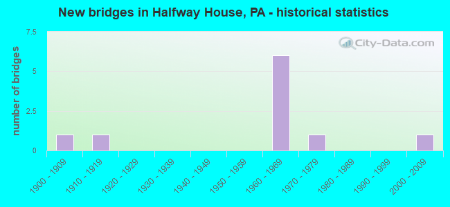
- New bridges - historical statistics
- 11900-1909
- 11910-1919
- 61960-1969
- 11970-1979
- 12000-2009

- Reconstructed bridges - Historical Statistics
- 11960-1969
- 01970-1979
- 11980-1989


- Bridge Condition - Deck
- 40.0%Good
- 60.0%Fair

- Bridge Condition - Superstructure
- 16.7%Good
- 16.7%Satisfactory
- 50.0%Fair
- 16.7%Poor

- Bridge Condition - Substructure
- 50.0%Good
- 33.3%Fair
- 16.7%Poor

- Bridge Condition - Channel
- 20.0%Good
- 20.0%Satisfactory
- 20.0%Fair
- 40.0%Poor
Find on map >> Show street view
Structure Number: 5108, Location: GRESHVILLE ROAD (Lat: 40.307853, Lng: -75.658158), Route carried "on" structure: State highway , Year Built: 1912, Status: Posted for load, Structure Length: 1.22m (4.00ft), Average Daily Traffic: 1,215 (year 2020), Truck Traffic: 6%, Average Future Daily Traffic: 1,815 (year 2032), Features Intersected: IRONSTONE CREEK, Facility Carried by Structure: SR 2042 (LR 06104)
Minimum Vertical Clearance: 30+ m (98+ ft), Kilometerpoint: 1.072, Lanes on structure: 2, Owner: State Highway Agency, Approaching Roadway Width: 6.7m (22.0ft), Material/Design: Concrete, Design/Construction: Arch - Deck, Number Of Spans In Main Unit: 1, Length of Maximum Span: 12.2m (40.0ft), Curb-To-Curb Width: 5.5m (18.0ft), Out-to-Out Width: 6.1m (20.0ft)
Condition: Superstructure: Fair, Substructure: Fair, Channel: Poor, Operating Rating: 33.6 metric tons, Method Used To Determine Operating Rating: Load Factor (LF), Inventory Rating: 20.0 metric tons, Method Used To Determine Inventory Rating: Load Factor (LF), Structural Evaluation: Somewhat better than minimum adequacy, Deck Geometry: High priority of replacement, Waterway Adequacy: Better than present minimum criteria, Approach Roadway Alignment: Equal to present desirable criteria, Bridge Posting: Required (Relationship of Operating Rating to Maximum Legal Load: 30.0 - 39.9% below), Length Of Structure Improvement: 1.90m (6.23ft), Designated Inspection Frequency: Every 24 months, Other Special Inspection Frequency: Every 12 months, Inspection Date: June 2020, Other Special Inspection Date: June 2021, Bridge Improvement Cost: $31,000, Roadway Improvement Cost: $92,000, Total Project Cost: $421,000
Find on map >> Show street view
Structure Number: 535, Location: 0.4 MI. WEST OF SR 2065 (Lat: 40.299253, Lng: -75.663247), Route carried "on" structure: City street , Year Built: 1973, Status: Open, Structure Length: 1.65m (5.41ft), Average Daily Traffic: 120 (year 2009), Average Future Daily Traffic: 150 (year 2019), Features Intersected: IRONSTONE CREEK, Facility Carried by Structure: CREAMERY RD
Minimum Vertical Clearance: 30+ m (98+ ft), Kilometerpoint: 0.000, Lanes on structure: 2, Owner: Town or Township Highway Agency, Approaching Roadway Width: 6.7m (22.0ft), Skew: 4 degrees, Material/Design: Prestressed concrete, Design/Construction: Box Beam or Girders - Single/Spread, Number Of Spans In Main Unit: 1, Length of Maximum Span: 15.8m (51.8ft), Curb or Sidewalk Widths: Left: 0.2m (0.7ft), Right: 0.2m (0.7ft), Curb-To-Curb Width: 10.4m (34.1ft), Out-to-Out Width: 11.6m (38.1ft)
Condition: Deck: Fair, Superstructure: Fair, Substructure: Good, Channel: Good, Operating Rating: 67.1 metric tons, Method Used To Determine Operating Rating: Load Factor (LF), Inventory Rating: 35.4 metric tons, Method Used To Determine Inventory Rating: Load Factor (LF), Structural Evaluation: Somewhat better than minimum adequacy, Deck Geometry: Better than present minimum criteria, Waterway Adequacy: Equal to present desirable criteria, Approach Roadway Alignment: Equal to present desirable criteria, Designated Inspection Frequency: Every 24 months, Inspection Date: June 2020, Deck Structure Type: Concrete Cast-file-Place, Wearing Surface/Protective System: Wearing Surface: Monolithic Concrete
Find on map >> Show street view
Structure Number: 5351, Location: 0.3 MI. SO.OF SR 2042 (Lat: 40.303256, Lng: -75.662147), Route carried "on" structure: City street , Year Built: 1963, Status: Open, Structure Length: 0.94m (3.08ft), Average Daily Traffic: 190 (year 2009), Truck Traffic: 1%, Average Future Daily Traffic: 280 (year 2019), Features Intersected: IRONSTONE CREEK, Facility Carried by Structure: WINDING ROAD
Minimum Vertical Clearance: 30+ m (98+ ft), Kilometerpoint: 0.000, Lanes on structure: 2, Owner: Town or Township Highway Agency, Approaching Roadway Width: 6.1m (20.0ft), Skew: 2 degrees, Material/Design: Concrete, Design/Construction: Slab, Number Of Spans In Main Unit: 1, Length of Maximum Span: 8.8m (28.9ft), Curb-To-Curb Width: 7.6m (24.9ft), Out-to-Out Width: 8.7m (28.5ft)
Condition: Deck: Fair, Superstructure: Fair, Substructure: Poor, Channel: Poor, Operating Rating: 63.5 metric tons, Method Used To Determine Operating Rating: Load Factor (LF), Inventory Rating: 38.1 metric tons, Method Used To Determine Inventory Rating: Load Factor (LF), Structural Evaluation: Meets minimum limits, Deck Geometry: Somewhat better than minimum adequacy, Waterway Adequacy: Better than present minimum criteria, Approach Roadway Alignment: Meets minimum limits, Designated Inspection Frequency: Every 24 months, Inspection Date: June 2020, Deck Structure Type: Concrete Cast-file-Place, Wearing Surface/Protective System: Wearing Surface: Monolithic Concrete
Find on map >> Show street view
Structure Number: 5352, Location: GLENDALE BRIDGE (Lat: 40.291111, Lng: -75.674000), Route carried "on" structure: Other road , Year Built: 1906, Year Reconstructed: 1966, Status: Posted for load, Structure Length: 1.68m (5.51ft), Average Daily Traffic: 114 (year 2018), Average Future Daily Traffic: 128 (year 2038), Design Load: HS 20, Features Intersected: IRONSTONE CREEK, Facility Carried by Structure: WINDING ROAD
Minimum Vertical Clearance: 30+ m (98+ ft), Kilometerpoint: 0.000, Lanes on structure: 2, Owner: County Highway Agency, Approaching Roadway Width: 4.9m (16.1ft), Material/Design: Steel, Design/Construction: Girder and Floorbeam System, Number Of Spans In Main Unit: 1, Length of Maximum Span: 16.2m (53.1ft), Curb-To-Curb Width: 5.0m (16.4ft), Out-to-Out Width: 5.8m (19.0ft)
Condition: Deck: Fair, Superstructure: Poor, Substructure: Fair, Channel: Fair, Operating Rating: 25.4 metric tons, Method Used To Determine Operating Rating: Load Factor (LF), Inventory Rating: 14.5 metric tons, Method Used To Determine Inventory Rating: Load Factor (LF), Structural Evaluation: Meets minimum limits, Deck Geometry: High priority of replacement, Waterway Adequacy: Equal to present minimum criteria, Approach Roadway Alignment: Meets minimum limits, Bridge Posting: Required (Relationship of Operating Rating to Maximum Legal Load: > 39.9% below), Length Of Structure Improvement: 2.10m (6.89ft), Designated Inspection Frequency: Every 24 months, Critical Feature Inspection Frequency: Every 12 months, Other Special Inspection Frequency: Every 12 months, Inspection Date: June 2021, Critical Feature Inspection Date: June 2021, Other Special Inspection Date: June 2021, Bridge Improvement Cost: $33,000, Roadway Improvement Cost: $96,000, Total Project Cost: $441,000, Wearing Surface/Protective System: Wearing Surface: Monolithic Concrete
Find on map >> Show street view
Structure Number: 27301, Location: HALFWAY HOUSE 11F3/3026G5 (Lat: 40.286228, Lng: -75.643922), Route carried "on" structure: State highway 100, Year Built: 1964, Year Reconstructed: 1988, Status: Open, Structure Length: 1.16m (3.81ft), Average Daily Traffic: 23,150 (year 2022), Truck Traffic: 13%, Average Future Daily Traffic: 35,336 (year 2032), Design Load: HS 20, Features Intersected: PINE FORD ROAD (LOCAL)
Minimum Vertical Clearance: 30+ m (98+ ft), Kilometerpoint: 5.386, Lanes on structure: 2, Lanes under structure: 2, Base Highway Network: Yes, Owner: State Highway Agency, Approaching Roadway Width: 18.9m (62.0ft), Skew: 33 degrees, Material/Design: Prestressed concrete, Design/Construction: Box Beam or Girders - Single/Spread, Number Of Spans In Main Unit: 1, Length of Maximum Span: 11.0m (36.1ft), Curb or Sidewalk Widths: Left: 0.2m (0.7ft), Right: 0.2m (0.7ft), Curb-To-Curb Width: 24.8m (81.4ft), Out-to-Out Width: 27.7m (90.9ft)
Condition: Deck: Good, Superstructure: Good, Substructure: Good, Operating Rating: 62.6 metric tons, Method Used To Determine Operating Rating: Load Factor (LF), Inventory Rating: 33.6 metric tons, Method Used To Determine Inventory Rating: Load Factor (LF), Structural Evaluation: Better than present minimum criteria, Deck Geometry: Superior to present desirable criteria, Underclear: Meets minimum limits, Approach Roadway Alignment: Equal to present desirable criteria, Length Of Structure Improvement: 1.70m (5.58ft), Designated Inspection Frequency: Every 24 months, Inspection Date: July 2021, Deck Structure Type: Concrete Cast-file-Place, Wearing Surface/Protective System: Wearing Surface: Latex Concrete
Find on map >> Show street view
Structure Number: 27862, Location: U. POTTSGROVE 11F3/3026H4 (Lat: 40.289375, Lng: -75.643058), Route carried "on" structure: State highway , Year Built: 1964, Status: Open, Structure Length: 3.44m (11.29ft), Average Daily Traffic: 4,222 (year 2022), Truck Traffic: 2%, Average Future Daily Traffic: 6,012 (year 2032), Design Load: HS 20, Features Intersected: PA 100, Facility Carried by Structure: FARMINGTON AVENUE
Minimum Vertical Clearance: 30+ m (98+ ft), Kilometerpoint: 2.372, Lanes on structure: 2, Lanes under structure: 4, Owner: State Highway Agency, Approaching Roadway Width: 13.1m (43.0ft), Skew: 3 degrees, Material/Design: Steel, Design/Construction: Stringer/Multi-beam, Number Of Spans In Main Unit: 1, Length of Maximum Span: 33.8m (110.9ft), Curb or Sidewalk Widths: Left: 0.5m (1.6ft), Right: 0.5m (1.6ft), Curb-To-Curb Width: 12.2m (40.0ft), Out-to-Out Width: 13.9m (45.6ft)
Condition: Deck: Good, Superstructure: Satisfactory, Substructure: Good, Operating Rating: 73.5 metric tons, Method Used To Determine Operating Rating: Load Factor (LF), Inventory Rating: 43.5 metric tons, Method Used To Determine Inventory Rating: Load Factor (LF), Structural Evaluation: Equal to present minimum criteria, Deck Geometry: Equal to present minimum criteria, Underclear: Meets minimum limits, Approach Roadway Alignment: Equal to present desirable criteria, Length Of Structure Improvement: 4.30m (14.11ft), Designated Inspection Frequency: Every 24 months, Inspection Date: October 2019, Bridge Improvement Cost: $83,000, Roadway Improvement Cost: $244,000, Total Project Cost: $1,118,000, Deck Structure Type: Concrete Cast-file-Place, Wearing Surface/Protective System: Wearing Surface: Latex Concrete
Find on map >> Show street view
Structure Number: 40894, Location: WEST OF 663 11J5/3026K6 (Lat: 40.276258, Lng: -75.625144), Route carried "on" structure: State highway , Year Built: 2000, Status: Open, Structure Length: 1.28m (4.20ft), Average Daily Traffic: 3,085 (year 2022), Truck Traffic: 5%, Average Future Daily Traffic: 3,341 (year 2032), Design Load: HS 25 or greater, Features Intersected: SPROGELS RUN, Facility Carried by Structure: MAUGERS MILL ROAD
Minimum Vertical Clearance: 30+ m (98+ ft), Kilometerpoint: 0.756, Lanes on structure: 2, Owner: State Highway Agency, Approaching Roadway Width: 9.1m (29.9ft), Skew: 6 degrees, Material/Design: Concrete, Design/Construction: Culvert, Number Of Spans In Main Unit: 1, Length of Maximum Span: 12.8m (42.0ft)
Condition: Channel: Satisfactory, Culverts: Good, Inventory Rating: 65.3 metric tons, Method Used To Determine Inventory Rating: Load Factor (LF), Structural Evaluation: Better than present minimum criteria, Waterway Adequacy: Equal to present desirable criteria, Approach Roadway Alignment: Equal to present desirable criteria, Length Of Structure Improvement: 1.90m (6.23ft), Designated Inspection Frequency: Every 24 months, Inspection Date: November 2019
Find on map >> Show street view
Structure Number: 27301, Location: HALFWAY HOUSE 11F3/3026G5 (Lat: 40.286228, Lng: -75.643922), Route carried "under" structure: County highway , Year Built: 1964, Structure Length: 0. m, Average Daily Traffic: 3,000 (year 1980), Truck Traffic: 7%, Features Intersected: PINE FORD ROAD (LOCAL), Facility Carried by Structure: TRAFFIC ROUTE 100
Minimum Vertical Clearance: 4.50m (14.76ft), Kilometerpoint: 0.000, Lanes on structure: 2, Lanes under structure: 2, Material/Design: Prestressed concrete, Design/Construction: Box Beam or Girders - Single/Spread, Length of Maximum Span: 11.0m (36.1ft)
Find on map >> Show street view
Structure Number: 27862, Location: U. POTTSGROVE 11F3/3026H4 (Lat: 40.289375, Lng: -75.643058), Route carried "under" structure: State highway 100, Year Built: 1964, Structure Length: 0. m, Average Daily Traffic: 10,754 (year 2022), Truck Traffic: 8%, Features Intersected: PA 100, Facility Carried by Structure: FARMINGTON AVENUE
Minimum Vertical Clearance: 4.88m (16.01ft), Kilometerpoint: 5.741, Lanes on structure: 2, Lanes under structure: 2, Material/Design: Steel, Design/Construction: Stringer/Multi-beam, Length of Maximum Span: 33.8m (110.9ft)
Find on map >> Show street view
Structure Number: 27862, Location: U. POTTSGROVE 11F3/3026H4 (Lat: 40.289375, Lng: -75.643058), Route carried "under" structure: State highway 100, Year Built: 1964, Structure Length: 0. m, Average Daily Traffic: 10,621 (year 2022), Truck Traffic: 8%, Features Intersected: PA 100, Facility Carried by Structure: FARMINGTON AVENUE
Minimum Vertical Clearance: 4.39m (14.40ft), Kilometerpoint: 5.750, Lanes on structure: 2, Lanes under structure: 2, Material/Design: Steel, Design/Construction: Stringer/Multi-beam, Length of Maximum Span: 33.8m (110.9ft)