Bridge Statistics for Groveland, Idaho (ID)
Condition, Traffic, Stress, Structural Evaluation, Project Costs
- National Bridge Inventory (NBI) Statistics
- 14Number of bridges
- 75ft / 22.7mTotal length
- $1,639,000Total costs
- 16,800Total average daily traffic
- 2,572Total average daily truck traffic
- 25,201Total future (year 2039) average daily traffic
- National Bridge Inventory (NBI) Registered Bridges for Groveland
- No street view available for this location
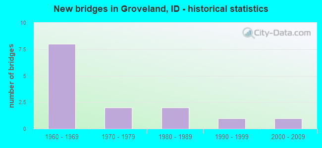
- New bridges - historical statistics
- 81960-1969
- 21970-1979
- 21980-1989
- 11990-1999
- 12000-2009


- Bridge Condition - Deck
- 50.0%Good
- 42.9%Satisfactory
- 7.1%Fair

- Bridge Condition - Superstructure
- 28.6%Good
- 64.3%Satisfactory
- 7.1%Fair

- Bridge Condition - Substructure
- 14.3%Good
- 71.4%Satisfactory
- 14.3%Fair

- Bridge Condition - Channel
- 30.8%Very good
- 69.2%Good
Find on map >> Show street view
Structure Number: 11885, Location: 4.6 N. HAMER (Lat: 43.990417, Lng: -112.230472), Route carried "on" structure: Interstate 15, Year Built: 1963, Status: Open, Structure Length: 0.98m (3.22ft), Average Daily Traffic: 1,700 (year 2019), Truck Traffic: 32%, Average Future Daily Traffic: 2,550 (year 2039), Design Load: HS 20, Features Intersected: CAMAS CREEK
Minimum Vertical Clearance: 30+ m (98+ ft), Kilometerpoint: 248.130, Lanes on structure: 2, Base Highway Network: Yes, Owner: State Highway Agency, Approaching Roadway Width: 13.4m (44.0ft), Material/Design: Concrete, Design/Construction: Tee Beam, Number Of Spans In Main Unit: 1, Length of Maximum Span: 9.1m (29.9ft), Curb-To-Curb Width: 13.4m (44.0ft), Out-to-Out Width: 14.0m (45.9ft)
Condition: Deck: Good, Superstructure: Good, Substructure: Satisfactory, Channel: Good, Operating Rating: 52.6 metric tons, Method Used To Determine Operating Rating: Load Factor (LF), Inventory Rating: 30.8 metric tons, Method Used To Determine Inventory Rating: Load Factor (LF), Structural Evaluation: Equal to present minimum criteria, Deck Geometry: Superior to present desirable criteria, Waterway Adequacy: Superior to present desirable criteria, Approach Roadway Alignment: Equal to present desirable criteria, Designated Inspection Frequency: Every 24 months, Inspection Date: November 2021, Deck Structure Type: Concrete Cast-file-Place, Wearing Surface/Protective System: Wearing Surface: Latex Concrete
Find on map >> Show street view
Structure Number: 1431, Location: 3 S. NAMPA (Lat: 43.504139, Lng: -116.573000), Route carried "on" structure: State highway 45, Year Built: 1961, Status: Open, Structure Length: 1.89m (6.20ft), Average Daily Traffic: 4,500 (year 2019), Truck Traffic: 6%, Average Future Daily Traffic: 6,750 (year 2039), Design Load: HS 20, Features Intersected: NEW YORK CANAL
Minimum Vertical Clearance: 30+ m (98+ ft), Kilometerpoint: 35.898, Lanes on structure: 2, Base Highway Network: Yes (Inventory Route: SH0, Subroute: 1), Owner: State Highway Agency, Approaching Roadway Width: 9.8m (32.2ft), Skew: 1 degrees, Material/Design: Concrete, Design/Construction: Tee Beam, Number Of Spans In Main Unit: 1, Length of Maximum Span: 18.3m (60.0ft), Curb or Sidewalk Widths: Left: 0.3m (1.0ft), Right: 0.3m (1.0ft), Curb-To-Curb Width: 10.4m (34.1ft), Out-to-Out Width: 11.2m (36.7ft)
Condition: Deck: Fair, Superstructure: Satisfactory, Substructure: Satisfactory, Channel: Very good, Operating Rating: 49.0 metric tons, Method Used To Determine Operating Rating: Load Factor (LF), Inventory Rating: 29.0 metric tons, Method Used To Determine Inventory Rating: Load Factor (LF), Structural Evaluation: Equal to present minimum criteria, Deck Geometry: Somewhat better than minimum adequacy, Waterway Adequacy: Equal to present desirable criteria, Approach Roadway Alignment: Equal to present desirable criteria, Length Of Structure Improvement: 2.13m (6.99ft), Designated Inspection Frequency: Every 24 months, Inspection Date: Febuary 2021, Bridge Improvement Cost: $554,000, Roadway Improvement Cost: $55,000, Total Project Cost: $832,000 ( Estimate for 2021), Deck Structure Type: Concrete Cast-file-Place, Wearing Surface/Protective System: Wearing Surface: Monolithic Concrete
Find on map >> Show street view
Structure Number: 1712, Location: KELLOGG;HILL STREET (Lat: 47.539833, Lng: -116.124250), Route carried "on" structure: Interstate 90, Year Built: 1964, Status: Open, Structure Length: 4.42m (14.50ft), Average Daily Traffic: 6,250 (year 2019), Truck Traffic: 21%, Average Future Daily Traffic: 9,375 (year 2039), Design Load: HS 20, Features Intersected: HILL STREET IC
Minimum Vertical Clearance: 30+ m (98+ ft), Kilometerpoint: 80.963, Lanes on structure: 2, Lanes under structure: 4, Base Highway Network: Yes (Inventory Route: I, Subroute: 1), Owner: State Highway Agency, Approaching Roadway Width: 11.9m (39.0ft), Skew: 1 degrees, Material/Design: Steel, Design/Construction: Stringer/Multi-beam, Number Of Spans In Main Unit: 3, Length of Maximum Span: 21.9m (71.9ft), Curb-To-Curb Width: 11.5m (37.7ft), Out-to-Out Width: 12.2m (40.0ft)
Condition: Deck: Satisfactory, Superstructure: Fair, Substructure: Fair, Operating Rating: 73.5 metric tons, Method Used To Determine Operating Rating: Load Factor (LF), Inventory Rating: 43.5 metric tons, Method Used To Determine Inventory Rating: Load Factor (LF), Structural Evaluation: Somewhat better than minimum adequacy, Deck Geometry: Somewhat better than minimum adequacy, Underclear: Equal to present minimum criteria, Approach Roadway Alignment: Equal to present desirable criteria, Designated Inspection Frequency: Every 24 months, Other Special Inspection Frequency: Every 48 months, Inspection Date: April 2021, Other Special Inspection Date: April 2021, Deck Structure Type: Concrete Cast-file-Place, Wearing Surface/Protective System: Wearing Surface: Latex Concrete
Find on map >> Show street view
Structure Number: 22325, Location: 2.2 N. 1.2 W. GROVELAND (Lat: 43.251861, Lng: -112.395417), Route carried "on" structure: County highway , Year Built: 1982, Status: Open, Structure Length: 1.77m (5.81ft), Average Daily Traffic: 315 (year 2019), Truck Traffic: 10%, Average Future Daily Traffic: 473 (year 2039), Design Load: HS 20, Features Intersected: ABERDEEN SPRINGFIELD CNL, Facility Carried by Structure: BOND ROAD
Minimum Vertical Clearance: 30+ m (98+ ft), Kilometerpoint: 165.473, Lanes on structure: 2, Owner: County Highway Agency, Approaching Roadway Width: 7.3m (24.0ft), Skew: 3 degrees, Material/Design: Steel, Design/Construction: Stringer/Multi-beam, Number Of Spans In Main Unit: 2, Length of Maximum Span: 8.5m (27.9ft), Curb or Sidewalk Widths: Left: 0.3m (1.0ft), Right: 0.3m (1.0ft), Curb-To-Curb Width: 9.1m (29.9ft), Out-to-Out Width: 9.8m (32.2ft)
Condition: Deck: Satisfactory, Superstructure: Satisfactory, Substructure: Good, Channel: Good, Operating Rating: 70.8 metric tons, Method Used To Determine Operating Rating: Load Factor (LF), Inventory Rating: 42.6 metric tons, Method Used To Determine Inventory Rating: Load Factor (LF), Structural Evaluation: Equal to present minimum criteria, Deck Geometry: Equal to present minimum criteria, Waterway Adequacy: Equal to present desirable criteria, Approach Roadway Alignment: Equal to present desirable criteria, Designated Inspection Frequency: Every 48 months, Inspection Date: March 2018, Deck Structure Type: Concrete Cast-file-Place, Wearing Surface/Protective System: Wearing Surface: Bituminous
Find on map >> Show street view
Structure Number: 2268, Location: 2.4 N. 0.5 E. GROVELAND (Lat: 43.254583, Lng: -112.362861), Route carried "on" structure: County highway , Year Built: 1976, Status: Posted for load, Structure Length: 1.07m (3.51ft), Average Daily Traffic: 100 (year 2019), Truck Traffic: 10%, Average Future Daily Traffic: 150 (year 2039), Design Load: HS 15, Features Intersected: PEOPLES CANAL, Facility Carried by Structure: W 400 N;WAREING RD
Minimum Vertical Clearance: 30+ m (98+ ft), Kilometerpoint: 161.962, Lanes on structure: 2, Owner: County Highway Agency, Approaching Roadway Width: 7.9m (25.9ft), Skew: 1 degrees, Material/Design: Prestressed concrete, Design/Construction: Tee Beam, Number Of Spans In Main Unit: 1, Length of Maximum Span: 10.4m (34.1ft), Curb or Sidewalk Widths: Left: 0.3m (1.0ft), Right: 0.3m (1.0ft), Curb-To-Curb Width: 8.5m (27.9ft), Out-to-Out Width: 9.1m (29.9ft)
Condition: Deck: Good, Superstructure: Satisfactory, Substructure: Satisfactory, Channel: Good, Operating Rating: 27.2 metric tons, Method Used To Determine Operating Rating: Field evaluation and documented engineering judgment, Inventory Rating: 16.3 metric tons, Method Used To Determine Inventory Rating: Field evaluation and documented engineering judgment, Structural Evaluation: Somewhat better than minimum adequacy, Deck Geometry: Better than present minimum criteria, Waterway Adequacy: Better than present minimum criteria, Approach Roadway Alignment: Equal to present desirable criteria, Bridge Posting: Required (Relationship of Operating Rating to Maximum Legal Load: 0.1 - 9.9% below), Length Of Structure Improvement: 1.52m (4.99ft), Designated Inspection Frequency: Every 24 months, Inspection Date: March 2020, Bridge Improvement Cost: $231,000, Roadway Improvement Cost: $23,000, Total Project Cost: $347,000 ( Estimate for 2020), Deck Structure Type: Concrete Cast-file-Place, Wearing Surface/Protective System: Wearing Surface: Bituminous
Find on map >> Show street view
Structure Number: 22715, Location: 1.2 W. GROVELAND (Lat: 43.218361, Lng: -112.395611), Route carried "on" structure: County highway , Year Built: 1968, Status: Open, Structure Length: 0.79m (2.59ft), Average Daily Traffic: 960 (year 2019), Truck Traffic: 6%, Average Future Daily Traffic: 1,440 (year 2039), Design Load: H 20, Features Intersected: DANSKIN CANAL, Facility Carried by Structure: BOND ROAD
Minimum Vertical Clearance: 30+ m (98+ ft), Kilometerpoint: 161.753, Lanes on structure: 2, Owner: County Highway Agency, Approaching Roadway Width: 7.3m (24.0ft), Skew: 1 degrees, Material/Design: Prestressed concrete, Design/Construction: Tee Beam, Number Of Spans In Main Unit: 1, Length of Maximum Span: 7.6m (24.9ft), Curb or Sidewalk Widths: Left: 0.3m (1.0ft), Right: 0.3m (1.0ft), Curb-To-Curb Width: 8.5m (27.9ft), Out-to-Out Width: 9.1m (29.9ft)
Condition: Deck: Good, Superstructure: Good, Substructure: Good, Channel: Good, Operating Rating: 47.2 metric tons, Method Used To Determine Operating Rating: Field evaluation and documented engineering judgment, Inventory Rating: 28.1 metric tons, Method Used To Determine Inventory Rating: Field evaluation and documented engineering judgment, Structural Evaluation: Better than present minimum criteria, Deck Geometry: Somewhat better than minimum adequacy, Waterway Adequacy: Better than present minimum criteria, Approach Roadway Alignment: Better than present minimum criteria, Designated Inspection Frequency: Every 24 months, Inspection Date: March 2020, Deck Structure Type: Concrete Cast-file-Place, Wearing Surface/Protective System: Wearing Surface: Bituminous
Find on map >> Show street view
Structure Number: 2272, Location: 2.9 N. 1.9 E. GROVELAND (Lat: 43.261231, Lng: -112.335989), Route carried "on" structure: County highway , Year Built: 1967, Status: Open, Structure Length: 1.28m (4.20ft), Average Daily Traffic: 140 (year 2019), Truck Traffic: 10%, Average Future Daily Traffic: 210 (year 2039), Design Load: H 20, Features Intersected: PEOPLES CANAL, Facility Carried by Structure: JOHNSON RD; 200 W
Minimum Vertical Clearance: 30+ m (98+ ft), Kilometerpoint: 165.290, Lanes on structure: 2, Owner: County Highway Agency, Approaching Roadway Width: 7.9m (25.9ft), Material/Design: Prestressed concrete, Design/Construction: Tee Beam, Number Of Spans In Main Unit: 1, Length of Maximum Span: 12.5m (41.0ft), Curb or Sidewalk Widths: Left: 0.3m (1.0ft), Right: 0.3m (1.0ft), Curb-To-Curb Width: 7.9m (25.9ft), Out-to-Out Width: 8.5m (27.9ft)
Condition: Deck: Good, Superstructure: Satisfactory, Substructure: Satisfactory, Channel: Good, Operating Rating: 34.5 metric tons, Method Used To Determine Operating Rating: Field evaluation and documented engineering judgment, Inventory Rating: 20.9 metric tons, Method Used To Determine Inventory Rating: Field evaluation and documented engineering judgment, Structural Evaluation: Equal to present minimum criteria, Deck Geometry: Somewhat better than minimum adequacy, Waterway Adequacy: Better than present minimum criteria, Approach Roadway Alignment: Somewhat better than minimum adequacy, Designated Inspection Frequency: Every 24 months, Inspection Date: November 2021, Deck Structure Type: Concrete Cast-file-Place, Wearing Surface/Protective System: Wearing Surface: Bituminous
Find on map >> Show street view
Structure Number: 22735, Location: 2.8 N. 1.9 E. GROVELAND (Lat: 43.260350, Lng: -112.336119), Route carried "on" structure: County highway , Year Built: 1975, Status: Open, Structure Length: 2.07m (6.79ft), Average Daily Traffic: 150 (year 2019), Truck Traffic: 10%, Average Future Daily Traffic: 225 (year 2039), Design Load: HS 20, Features Intersected: ABERDEEN SPRINGFIELD CNL, Facility Carried by Structure: JOHNSON ROAD
Minimum Vertical Clearance: 30+ m (98+ ft), Kilometerpoint: 165.187, Lanes on structure: 2, Owner: County Highway Agency, Approaching Roadway Width: 7.9m (25.9ft), Skew: 2 degrees, Material/Design: Prestressed concrete, Design/Construction: Tee Beam, Number Of Spans In Main Unit: 2, Length of Maximum Span: 10.1m (33.1ft), Curb or Sidewalk Widths: Left: 0.3m (1.0ft), Right: 0.3m (1.0ft), Curb-To-Curb Width: 8.5m (27.9ft), Out-to-Out Width: 9.1m (29.9ft)
Condition: Deck: Good, Superstructure: Satisfactory, Substructure: Satisfactory, Channel: Good, Operating Rating: 34.5 metric tons, Method Used To Determine Operating Rating: Field evaluation and documented engineering judgment, Inventory Rating: 20.9 metric tons, Method Used To Determine Inventory Rating: Field evaluation and documented engineering judgment, Structural Evaluation: Equal to present minimum criteria, Deck Geometry: Equal to present minimum criteria, Waterway Adequacy: Better than present minimum criteria, Approach Roadway Alignment: Better than present minimum criteria, Designated Inspection Frequency: Every 24 months, Inspection Date: November 2021, Deck Structure Type: Concrete Cast-file-Place, Wearing Surface/Protective System: Wearing Surface: Bituminous
Find on map >> Show street view
Structure Number: 2278, Location: 2.5 N. 0.9 E. GROVELAND (Lat: 43.256811, Lng: -112.355850), Route carried "on" structure: County highway , Year Built: 1968, Status: Open, Structure Length: 1.28m (4.20ft), Average Daily Traffic: 200 (year 2019), Truck Traffic: 10%, Average Future Daily Traffic: 300 (year 2039), Design Load: H 20, Features Intersected: PEOPLES CANAL, Facility Carried by Structure: WASHINGTON ROAD
Minimum Vertical Clearance: 30+ m (98+ ft), Kilometerpoint: 166.786, Lanes on structure: 2, Owner: County Highway Agency, Approaching Roadway Width: 7.9m (25.9ft), Skew: 1 degrees, Material/Design: Prestressed concrete, Design/Construction: Tee Beam, Number Of Spans In Main Unit: 1, Length of Maximum Span: 12.5m (41.0ft), Curb or Sidewalk Widths: Left: 0.3m (1.0ft), Right: 0.3m (1.0ft), Curb-To-Curb Width: 8.5m (27.9ft), Out-to-Out Width: 9.1m (29.9ft)
Condition: Deck: Good, Superstructure: Good, Substructure: Satisfactory, Channel: Good, Operating Rating: 34.5 metric tons, Method Used To Determine Operating Rating: Field evaluation and documented engineering judgment, Inventory Rating: 20.9 metric tons, Method Used To Determine Inventory Rating: Field evaluation and documented engineering judgment, Structural Evaluation: Equal to present minimum criteria, Deck Geometry: Equal to present minimum criteria, Waterway Adequacy: Better than present minimum criteria, Approach Roadway Alignment: Equal to present desirable criteria, Designated Inspection Frequency: Every 24 months, Inspection Date: November 2021, Deck Structure Type: Concrete Cast-file-Place, Wearing Surface/Protective System: Wearing Surface: Bituminous
Find on map >> Show street view
Structure Number: 228, Location: 5.0 N. 0.6 W. BLACKFOOT (Lat: 43.261761, Lng: -112.355600), Route carried "on" structure: County highway , Year Built: 1967, Status: Open, Structure Length: 1.68m (5.51ft), Average Daily Traffic: 200 (year 2019), Truck Traffic: 10%, Average Future Daily Traffic: 300 (year 2039), Design Load: H 15, Features Intersected: ABERDEEN SPRINGFIELD CNL, Facility Carried by Structure: WASHINGTON RD;300W
Minimum Vertical Clearance: 30+ m (98+ ft), Kilometerpoint: 167.323, Lanes on structure: 2, Owner: County Highway Agency, Approaching Roadway Width: 7.3m (24.0ft), Material/Design: Prestressed concrete, Design/Construction: Tee Beam, Number Of Spans In Main Unit: 1, Length of Maximum Span: 16.5m (54.1ft), Curb or Sidewalk Widths: Left: 0.3m (1.0ft), Right: 0.3m (1.0ft), Curb-To-Curb Width: 8.5m (27.9ft), Out-to-Out Width: 9.1m (29.9ft)
Condition: Deck: Good, Superstructure: Good, Substructure: Satisfactory, Channel: Very good, Operating Rating: 47.2 metric tons, Method Used To Determine Operating Rating: Field evaluation and documented engineering judgment, Inventory Rating: 28.1 metric tons, Method Used To Determine Inventory Rating: Field evaluation and documented engineering judgment, Structural Evaluation: Equal to present minimum criteria, Deck Geometry: Equal to present minimum criteria, Waterway Adequacy: Equal to present desirable criteria, Approach Roadway Alignment: Equal to present minimum criteria, Designated Inspection Frequency: Every 24 months, Inspection Date: November 2021, Deck Structure Type: Concrete Cast-file-Place, Wearing Surface/Protective System: Wearing Surface: Bituminous
Find on map >> Show street view
Structure Number: 22861, Location: 2.8 N. 0.2 W. GROVELAND (Lat: 43.261689, Lng: -112.375439), Route carried "on" structure: County highway , Year Built: 2004, Status: Open, Structure Length: 1.46m (4.79ft), Average Daily Traffic: 300 (year 2019), Truck Traffic: 10%, Average Future Daily Traffic: 450 (year 2039), Design Load: HS 20, Features Intersected: ABERDEEN SPRINGFILED CNL, Facility Carried by Structure: MCDONALD ROAD
Minimum Vertical Clearance: 30+ m (98+ ft), Kilometerpoint: 162.970, Lanes on structure: 2, Owner: County Highway Agency, Approaching Roadway Width: 6.7m (22.0ft), Skew: 2 degrees, Material/Design: Concrete, Design/Construction: Frame, Number Of Spans In Main Unit: 2, Length of Maximum Span: 7.3m (24.0ft), Curb or Sidewalk Widths: Left: 2.1m (6.9ft), Right: 0.0m, Curb-To-Curb Width: 13.2m (43.3ft), Out-to-Out Width: 16.4m (53.8ft)
Condition: Deck: Satisfactory, Superstructure: Satisfactory, Substructure: Satisfactory, Channel: Very good, Operating Rating: 46.3 metric tons, Method Used To Determine Operating Rating: Load Factor (LF), Inventory Rating: 27.2 metric tons, Method Used To Determine Inventory Rating: Load Factor (LF), Structural Evaluation: Equal to present minimum criteria, Deck Geometry: Superior to present desirable criteria, Waterway Adequacy: Better than present minimum criteria, Approach Roadway Alignment: Equal to present desirable criteria, Designated Inspection Frequency: Every 24 months, Inspection Date: November 2021, Deck Structure Type: Concrete Cast-file-Place, Wearing Surface/Protective System: Wearing Surface: Bituminous
Find on map >> Show street view
Structure Number: 22906, Location: 2.1 N. 0.2 W. GROVELAND (Lat: 43.250819, Lng: -112.375569), Route carried "on" structure: County highway , Year Built: 1999, Status: Open, Structure Length: 1.01m (3.31ft), Average Daily Traffic: 190 (year 2019), Truck Traffic: 10%, Average Future Daily Traffic: 285 (year 2039), Design Load: HS 25 or greater, Features Intersected: PEOPLES CANAL, Facility Carried by Structure: MCDONALDVILLE ROAD
Minimum Vertical Clearance: 30+ m (98+ ft), Kilometerpoint: 161.712, Lanes on structure: 2, Owner: County Highway Agency, Approaching Roadway Width: 7.3m (24.0ft), Material/Design: Concrete, Design/Construction: Frame, Number Of Spans In Main Unit: 1, Length of Maximum Span: 10.1m (33.1ft), Curb-To-Curb Width: 11.3m (37.1ft), Out-to-Out Width: 12.2m (40.0ft)
Condition: Deck: Satisfactory, Superstructure: Satisfactory, Substructure: Satisfactory, Channel: Good, Operating Rating: 90.6 metric tons, Method Used To Determine Operating Rating: Load Factor (LF), Inventory Rating: 75.3 metric tons, Method Used To Determine Inventory Rating: Load Factor (LF), Structural Evaluation: Equal to present minimum criteria, Deck Geometry: Superior to present desirable criteria, Waterway Adequacy: Equal to present desirable criteria, Approach Roadway Alignment: Equal to present desirable criteria, Designated Inspection Frequency: Every 48 months, Inspection Date: November 2021, Deck Structure Type: Concrete Cast-file-Place, Wearing Surface/Protective System: Wearing Surface: Bituminous, Deck Protection: Epoxy Coated Reinforcing
Find on map >> Show street view
Structure Number: 2315, Location: 0.5 N. 1.8 W. KIMBALL (Lat: 43.285167, Lng: -112.248944), Route carried "on" structure: County highway , Year Built: 1986, Status: Open, Structure Length: 1.52m (4.99ft), Average Daily Traffic: 95 (year 2019), Truck Traffic: 10%, Average Future Daily Traffic: 143 (year 2039), Design Load: HS 20, Features Intersected: PEOPLES CANAL, Facility Carried by Structure: S. LAVASIDE ROAD
Minimum Vertical Clearance: 30+ m (98+ ft), Kilometerpoint: 165.687, Lanes on structure: 2, Owner: County Highway Agency, Approaching Roadway Width: 7.3m (24.0ft), Skew: 3 degrees, Material/Design: Steel, Design/Construction: Stringer/Multi-beam, Number Of Spans In Main Unit: 1, Length of Maximum Span: 14.6m (47.9ft), Curb-To-Curb Width: 7.2m (23.6ft), Out-to-Out Width: 7.9m (25.9ft)
Condition: Deck: Satisfactory, Superstructure: Satisfactory, Substructure: Satisfactory, Channel: Very good, Operating Rating: 40.8 metric tons, Method Used To Determine Operating Rating: Load Factor (LF), Inventory Rating: 24.5 metric tons, Method Used To Determine Inventory Rating: Load Factor (LF), Structural Evaluation: Equal to present minimum criteria, Deck Geometry: Somewhat better than minimum adequacy, Waterway Adequacy: Better than present minimum criteria, Approach Roadway Alignment: Equal to present minimum criteria, Designated Inspection Frequency: Every 24 months, Inspection Date: March 2020, Deck Structure Type: Concrete Cast-file-Place, Wearing Surface/Protective System: Wearing Surface: Monolithic Concrete
Find on map >> Show street view
Structure Number: 3253, Location: 0.2 S. 1.5 E. RIGBY (Lat: 43.665917, Lng: -111.884139), Route carried "on" structure: County highway , Year Built: 1969, Status: Open, Structure Length: 1.46m (4.79ft), Average Daily Traffic: 1,700 (year 2019), Truck Traffic: 13%, Average Future Daily Traffic: 2,550 (year 2039), Design Load: H 15, Features Intersected: BURGESS CNL;SE.RIGBY BR, Facility Carried by Structure: N 4100 E RD (MILO)
Minimum Vertical Clearance: 30+ m (98+ ft), Kilometerpoint: 8.502, Lanes on structure: 2, Owner: County Highway Agency, Approaching Roadway Width: 7.9m (25.9ft), Skew: 4 degrees, Material/Design: Prestressed concrete, Design/Construction: Channel Beam, Number Of Spans In Main Unit: 1, Length of Maximum Span: 14.3m (46.9ft), Curb or Sidewalk Widths: Left: 0.3m (1.0ft), Right: 0.3m (1.0ft), Curb-To-Curb Width: 7.9m (25.9ft), Out-to-Out Width: 8.5m (27.9ft)
Condition: Deck: Satisfactory, Superstructure: Satisfactory, Substructure: Fair, Channel: Good, Operating Rating: 27.2 metric tons, Method Used To Determine Operating Rating: Field evaluation and documented engineering judgment, Inventory Rating: 16.3 metric tons, Method Used To Determine Inventory Rating: Field evaluation and documented engineering judgment, Structural Evaluation: Meets minimum limits, Deck Geometry: Meets minimum limits, Waterway Adequacy: Better than present minimum criteria, Approach Roadway Alignment: Equal to present desirable criteria, Length Of Structure Improvement: 1.89m (6.20ft), Designated Inspection Frequency: Every 24 months, Inspection Date: March 2021, Bridge Improvement Cost: $307,000, Roadway Improvement Cost: $31,000, Total Project Cost: $460,000 ( Estimate for 2019), Deck Structure Type: Concrete Precast Panels, Wearing Surface/Protective System: Wearing Surface: Bituminous