Bridge Statistics for Grosse Tete, Louisiana (LA)
Condition, Traffic, Stress, Structural Evaluation, Project Costs
- National Bridge Inventory (NBI) Statistics
- 17Number of bridges
- 833ft / 254mTotal length
- $220,000Total costs
- 140,956Total average daily traffic
- 34,166Total average daily truck traffic
- National Bridge Inventory (NBI) Registered Bridges for Grosse Tete
- No street view available for this location
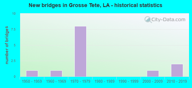
- New bridges - historical statistics
- 11950-1959
- 11960-1969
- 81970-1979
- 12000-2009
- 22010-2019


- Bridge Condition - Deck
- 46.2%Good
- 38.5%Satisfactory
- 7.7%Fair
- 7.7%Serious

- Bridge Condition - Superstructure
- 15.4%Very good
- 30.8%Good
- 30.8%Satisfactory
- 7.7%Fair
- 7.7%Poor
- 7.7%Serious

- Bridge Condition - Substructure
- 46.2%Good
- 38.5%Satisfactory
- 7.7%Fair
- 7.7%Poor

- Bridge Condition - Channel
- 36.4%Very good
- 36.4%Good
- 27.3%Satisfactory
Find on map >> Show street view
Structure Number: 612400000800813, Location: 0.1 OF A MILE WEST OF RAM (Lat: 30.401831, Lng: -91.510350), Route carried "on" structure: County highway , Year Built: 2014, Status: Posted for load, Structure Length: 6.10m (20.01ft), Average Daily Traffic: 550 (year 2019), Truck Traffic: 5%, Average Future Daily Traffic: 605 (year 2039), Design Load: HS 20, Features Intersected: LEVEE BORROW PIT, Facility Carried by Structure: MIMMS RD
Minimum Vertical Clearance: 30+ m (98+ ft), Kilometerpoint: 0.000, Lanes on structure: 2, Owner: County Highway Agency, Approaching Roadway Width: 9.4m (30.8ft), Skew: 36 degrees, Material/Design: Prestressed concrete, Design/Construction: Box Beam or Girders - Multiple, Number Of Spans In Main Unit: 5, Length of Maximum Span: 12.2m (40.0ft), Curb-To-Curb Width: 9.4m (30.8ft), Out-to-Out Width: 10.7m (35.1ft)
Condition: Deck: Good, Superstructure: Good, Substructure: Good, Channel: Good, Operating Rating: 62.2 metric tons, Method Used To Determine Operating Rating: Load and Resistance Factor Rating (LRFR) rating reported by rating factor(RF) method using HL-93 loadings, Inventory Rating: 45.0 metric tons, Method Used To Determine Inventory Rating: Load and Resistance Factor Rating (LRFR) rating reported by rating factor(RF) method using HL-93 loadings, Structural Evaluation: Better than present minimum criteria, Deck Geometry: Equal to present minimum criteria, Waterway Adequacy: Equal to present desirable criteria, Approach Roadway Alignment: Equal to present desirable criteria, Designated Inspection Frequency: Every 24 months, Underwater Inspection Frequency: Every 60 months, Inspection Date: December 2020, Underwater Inspection Date: March 2019, Deck Structure Type: Concrete Precast Panels, Wearing Surface/Protective System: Wearing Surface: Monolithic Concrete
Find on map >> Show street view
Structure Number: 612404050103781, Location: 2.4 Mi W of La 993 (Lat: 30.135800, Lng: -91.223919), Route carried "on" structure: State highway 404, Year Built: 1955, Status: Posted for load, Structure Length: 3.84m (12.60ft), Average Daily Traffic: 620 (year 2016), Truck Traffic: 10%, Average Future Daily Traffic: 471 (year 2036), Design Load: H 15, Features Intersected: BAYOU TIGRIS
Minimum Vertical Clearance: 30+ m (98+ ft), Kilometerpoint: 6.085, Lanes on structure: 2, Owner: State Highway Agency, Approaching Roadway Width: 10.4m (34.1ft), Material/Design: Steel, Design/Construction: Stringer/Multi-beam, Number Of Spans In Main Unit: 1, Number Of Approach Spans: 5, Length of Maximum Span: 9.1m (29.9ft), Curb-To-Curb Width: 7.9m (25.9ft), Out-to-Out Width: 8.6m (28.2ft)
Condition: Deck: Fair, Superstructure: Poor, Substructure: Satisfactory, Channel: Very good, Operating Rating: 9.1 metric tons, Method Used To Determine Operating Rating: Allowable Stress (AS), Inventory Rating: 5.6 metric tons, Method Used To Determine Inventory Rating: Allowable Stress (AS), Structural Evaluation: High priority of corrective action, Deck Geometry: Somewhat better than minimum adequacy, Waterway Adequacy: Equal to present desirable criteria, Approach Roadway Alignment: Equal to present desirable criteria, Bridge Posting: Required (Relationship of Operating Rating to Maximum Legal Load: > 39.9% below), Designated Inspection Frequency: Every 24 months, Other Special Inspection Frequency: Every 6 months, Inspection Date: April 2021, Other Special Inspection Date: October 2021, Deck Structure Type: Concrete Cast-file-Place, Wearing Surface/Protective System: Wearing Surface: Monolithic Concrete
Find on map >> Show street view
Structure Number: 612404500712131, Location: I0010 (Lat: 30.414831, Lng: -91.447831), Route carried "on" structure: Interstate 10, Year Built: 1972, Status: Open, Structure Length: 61.75m (202.59ft), Average Daily Traffic: 23,850 (year 2016), Truck Traffic: 28%, Average Future Daily Traffic: 21,386 (year 2036), Design Load: HS 20, Features Intersected: M.P. R.R.
Minimum Vertical Clearance: 30+ m (98+ ft), Kilometerpoint: 19.782, Lanes on structure: 2, Base Highway Network: Yes (Inventory Route: 450-07-1, Subroute: 10), Owner: State Highway Agency, Approaching Roadway Width: 18.9m (62.0ft), Skew: 10 degrees, Material/Design: Prestressed concrete, Design/Construction: Stringer/Multi-beam, Number Of Spans In Main Unit: 26, Length of Maximum Span: 23.8m (78.1ft), Curb-To-Curb Width: 12.0m (39.4ft), Out-to-Out Width: 13.0m (42.7ft)
Condition: Deck: Good, Superstructure: Very good, Substructure: Satisfactory, Operating Rating: 57.3 metric tons, Method Used To Determine Operating Rating: Load and Resistance Factor Rating (LRFR) rating reported by rating factor(RF) method using HL-93 loadings, Inventory Rating: 20.1 metric tons, Method Used To Determine Inventory Rating: Load and Resistance Factor Rating (LRFR) rating reported by rating factor(RF) method using HL-93 loadings, Structural Evaluation: Somewhat better than minimum adequacy, Deck Geometry: Equal to present minimum criteria, Underclear: Superior to present desirable criteria, Approach Roadway Alignment: Equal to present desirable criteria, Designated Inspection Frequency: Every 24 months, Inspection Date: October 2021, Deck Structure Type: Concrete Cast-file-Place, Wearing Surface/Protective System: Wearing Surface: Monolithic Concrete
Find on map >> Show street view
Structure Number: 612404500712132, Location: I0010 (Lat: 30.415019, Lng: -91.448061), Route carried "on" structure: Interstate 10, Year Built: 1972, Status: Open, Structure Length: 61.75m (202.59ft), Average Daily Traffic: 23,850 (year 2016), Truck Traffic: 28%, Average Future Daily Traffic: 21,386 (year 2036), Design Load: HS 20, Features Intersected: M.P. R.R.
Minimum Vertical Clearance: 30+ m (98+ ft), Kilometerpoint: 3.418, Lanes on structure: 2, Base Highway Network: Yes (Inventory Route: 450-07-2, Subroute: 10), Owner: State Highway Agency, Approaching Roadway Width: 18.9m (62.0ft), Skew: 10 degrees, Material/Design: Prestressed concrete, Design/Construction: Stringer/Multi-beam, Number Of Spans In Main Unit: 26, Length of Maximum Span: 23.8m (78.1ft), Curb-To-Curb Width: 12.0m (39.4ft), Out-to-Out Width: 13.0m (42.7ft)
Condition: Deck: Good, Superstructure: Good, Substructure: Satisfactory, Operating Rating: 57.3 metric tons, Method Used To Determine Operating Rating: Load and Resistance Factor Rating (LRFR) rating reported by rating factor(RF) method using HL-93 loadings, Inventory Rating: 20.1 metric tons, Method Used To Determine Inventory Rating: Load and Resistance Factor Rating (LRFR) rating reported by rating factor(RF) method using HL-93 loadings, Structural Evaluation: Somewhat better than minimum adequacy, Deck Geometry: Equal to present minimum criteria, Underclear: Superior to present desirable criteria, Approach Roadway Alignment: Equal to present desirable criteria, Designated Inspection Frequency: Every 24 months, Inspection Date: October 2021, Deck Structure Type: Concrete Cast-file-Place, Wearing Surface/Protective System: Wearing Surface: Monolithic Concrete
Find on map >> Show street view
Structure Number: 612404500712891, Location: I0010 (Lat: 30.418019, Lng: -91.435850), Route carried "on" structure: Interstate 10, Year Built: 1972, Status: Open, Structure Length: 43.59m (143.01ft), Average Daily Traffic: 31,450 (year 2016), Truck Traffic: 28%, Average Future Daily Traffic: 31,920 (year 2036), Design Load: HS 20, Features Intersected: LA 77, LA 411, BAYOU
Minimum Vertical Clearance: 30+ m (98+ ft), Kilometerpoint: 20.986, Lanes on structure: 2, Lanes under structure: 4, Base Highway Network: Yes (Inventory Route: 450-07-1, Subroute: 10), Owner: State Highway Agency, Approaching Roadway Width: 18.3m (60.0ft), Skew: 11 degrees, Material/Design: Prestressed concrete, Design/Construction: Stringer/Multi-beam, Number Of Spans In Main Unit: 26, Length of Maximum Span: 23.8m (78.1ft), Curb-To-Curb Width: 12.1m (39.7ft), Out-to-Out Width: 13.0m (42.7ft)
Condition: Deck: Satisfactory, Superstructure: Satisfactory, Substructure: Good, Channel: Good, Operating Rating: 84.4 metric tons, Method Used To Determine Operating Rating: Load Factor (LF), Inventory Rating: 33.6 metric tons, Method Used To Determine Inventory Rating: Load Factor (LF), Structural Evaluation: Equal to present minimum criteria, Deck Geometry: Equal to present minimum criteria, Underclear: Better than present minimum criteria, Waterway Adequacy: Equal to present desirable criteria, Approach Roadway Alignment: Equal to present desirable criteria, Designated Inspection Frequency: Every 24 months, Inspection Date: May 2021, Deck Structure Type: Concrete Cast-file-Place, Wearing Surface/Protective System: Wearing Surface: Monolithic Concrete
Find on map >> Show street view
Structure Number: 612404500712892, Location: I0010 (Lat: 30.418269, Lng: -91.435869), Route carried "on" structure: Interstate 10, Year Built: 1972, Status: Open, Structure Length: 43.59m (143.01ft), Average Daily Traffic: 31,450 (year 2016), Truck Traffic: 28%, Average Future Daily Traffic: 31,920 (year 2036), Design Load: HS 20, Features Intersected: LA 77, LA 411, BAYOU
Minimum Vertical Clearance: 30+ m (98+ ft), Kilometerpoint: 2.375, Lanes on structure: 2, Lanes under structure: 4, Base Highway Network: Yes (Inventory Route: 450-07-2, Subroute: 10), Owner: State Highway Agency, Approaching Roadway Width: 16.8m (55.1ft), Skew: 11 degrees, Material/Design: Prestressed concrete, Design/Construction: Stringer/Multi-beam, Number Of Spans In Main Unit: 26, Length of Maximum Span: 23.8m (78.1ft), Curb-To-Curb Width: 12.1m (39.7ft), Out-to-Out Width: 13.0m (42.7ft)
Condition: Deck: Good, Superstructure: Good, Substructure: Good, Channel: Very good, Operating Rating: 84.4 metric tons, Method Used To Determine Operating Rating: Load Factor (LF), Inventory Rating: 33.6 metric tons, Method Used To Determine Inventory Rating: Load Factor (LF), Structural Evaluation: Better than present minimum criteria, Deck Geometry: Equal to present minimum criteria, Waterway Adequacy: Equal to present desirable criteria, Approach Roadway Alignment: Equal to present desirable criteria, Designated Inspection Frequency: Every 24 months, Inspection Date: May 2021, Deck Structure Type: Concrete Cast-file-Place, Wearing Surface/Protective System: Wearing Surface: Monolithic Concrete
Find on map >> Show street view
Structure Number: 612404500712993, Location: I0010 (Lat: 30.418019, Lng: -91.433900), Route carried "on" structure: Ramp Interstate 10, Year Built: 1972, Status: Open, Structure Length: 6.10m (20.01ft), Average Daily Traffic: 5,430 (year 2018), Truck Traffic: 10%, Average Future Daily Traffic: 5,320 (year 2036), Design Load: HS 20, Features Intersected: BAYOU GROSSE TETE
Minimum Vertical Clearance: 30+ m (98+ ft), Kilometerpoint: 0.024, Lanes on structure: 1, Owner: State Highway Agency, Approaching Roadway Width: 16.5m (54.1ft), Material/Design: Steel, Design/Construction: Stringer/Multi-beam, Number Of Spans In Main Unit: 6, Length of Maximum Span: 15.2m (49.9ft), Curb-To-Curb Width: 7.6m (24.9ft), Out-to-Out Width: 8.6m (28.2ft)
Condition: Deck: Satisfactory, Superstructure: Satisfactory, Substructure: Satisfactory, Channel: Good, Operating Rating: 40.8 metric tons, Method Used To Determine Operating Rating: Load and Resistance Factor Rating (LRFR) rating reported by rating factor(RF) method using HL-93 loadings, Inventory Rating: 31.8 metric tons, Method Used To Determine Inventory Rating: Load and Resistance Factor Rating (LRFR) rating reported by rating factor(RF) method using HL-93 loadings, Structural Evaluation: Equal to present minimum criteria, Deck Geometry: Better than present minimum criteria, Waterway Adequacy: Equal to present desirable criteria, Approach Roadway Alignment: Equal to present desirable criteria, Designated Inspection Frequency: Every 24 months, Underwater Inspection Frequency: Every 60 months, Inspection Date: August 2021, Underwater Inspection Date: January 2019, Deck Structure Type: Open Grating
Find on map >> Show street view
Structure Number: 612404500712994, Location: I0010 (Lat: 30.419150, Lng: -91.434489), Route carried "on" structure: Ramp Interstate 10, Year Built: 1972, Status: Open, Structure Length: 6.10m (20.01ft), Average Daily Traffic: 5,430 (year 2018), Truck Traffic: 10%, Average Future Daily Traffic: 5,320 (year 2036), Design Load: HS 20, Features Intersected: BAYOU GROSSE TETE
Minimum Vertical Clearance: 30+ m (98+ ft), Kilometerpoint: 0.032, Lanes on structure: 1, Owner: State Highway Agency, Approaching Roadway Width: 16.5m (54.1ft), Material/Design: Steel, Design/Construction: Stringer/Multi-beam, Number Of Spans In Main Unit: 1, Number Of Approach Spans: 6, Length of Maximum Span: 15.2m (49.9ft), Curb-To-Curb Width: 7.6m (24.9ft), Out-to-Out Width: 8.6m (28.2ft)
Condition: Deck: Satisfactory, Superstructure: Satisfactory, Substructure: Satisfactory, Channel: Satisfactory, Operating Rating: 40.8 metric tons, Method Used To Determine Operating Rating: Load and Resistance Factor Rating (LRFR) rating reported by rating factor(RF) method using HL-93 loadings, Inventory Rating: 31.8 metric tons, Method Used To Determine Inventory Rating: Load and Resistance Factor Rating (LRFR) rating reported by rating factor(RF) method using HL-93 loadings, Structural Evaluation: Equal to present minimum criteria, Deck Geometry: Better than present minimum criteria, Waterway Adequacy: Equal to present desirable criteria, Approach Roadway Alignment: Equal to present desirable criteria, Designated Inspection Frequency: Every 24 months, Underwater Inspection Frequency: Every 60 months, Inspection Date: August 2021, Underwater Inspection Date: January 2019, Deck Structure Type: Open Grating
Find on map >> Show street view
Structure Number: 612430068910881, Location: 4 MI. S. OF WHITE CA (Lat: 30.113481, Lng: -91.148300), Route carried "on" structure: County highway , Year Built: 1975, Status: Posted for load, Structure Length: 1.77m (5.81ft), Average Daily Traffic: 90 (year 2019), Average Future Daily Traffic: 99 (year 2039), Design Load: HS 20, Features Intersected: DRAINAGE CANAL, Facility Carried by Structure: Grand Rd
Minimum Vertical Clearance: 30+ m (98+ ft), Kilometerpoint: 0.000, Lanes on structure: 2, Owner: County Highway Agency, Approaching Roadway Width: 7.6m (24.9ft), Material/Design: Concrete, Design/Construction: Slab, Number Of Spans In Main Unit: 3, Length of Maximum Span: 5.8m (19.0ft), Curb-To-Curb Width: 7.3m (24.0ft), Out-to-Out Width: 8.0m (26.2ft)
Condition: Deck: Serious, Superstructure: Serious, Substructure: Fair, Channel: Satisfactory, Operating Rating: 18.1 metric tons, Method Used To Determine Operating Rating: Load and Resistance Factor Rating (LRFR) rating reported by rating factor(RF) method using HL-93 loadings, Inventory Rating: 13.9 metric tons, Method Used To Determine Inventory Rating: Load and Resistance Factor Rating (LRFR) rating reported by rating factor(RF) method using HL-93 loadings, Structural Evaluation: High priority of corrective action, Deck Geometry: Equal to present minimum criteria, Waterway Adequacy: Better than present minimum criteria, Approach Roadway Alignment: Equal to present desirable criteria, Bridge Posting: Required (Relationship of Operating Rating to Maximum Legal Load: 30.0 - 39.9% below), Length Of Structure Improvement: 2.47m (8.10ft), Designated Inspection Frequency: Every 24 months, Other Special Inspection Frequency: Every 12 months, Inspection Date: December 2020, Other Special Inspection Date: December 2021, Bridge Improvement Cost: $147,000, Total Project Cost: $220,000 ( Estimate for 2016), Deck Structure Type: Concrete Precast Panels
Find on map >> Show street view
Structure Number: 612430223912371, Location: 0.3 MI.,NW.,JCT LA77 (Lat: 30.371619, Lng: -91.395069), Route carried "on" structure: County highway , Year Built: 1966, Status: Open, Structure Length: 3.84m (12.60ft), Average Daily Traffic: 400 (year 2019), Average Future Daily Traffic: 440 (year 2039), Design Load: HS 20, Features Intersected: BAYOU GROSS TETE, Facility Carried by Structure: Sidney Rd
Minimum Vertical Clearance: 30+ m (98+ ft), Kilometerpoint: 0.000, Lanes on structure: 2, Owner: County Highway Agency, Approaching Roadway Width: 10.4m (34.1ft), Material/Design: Steel, Design/Construction: Stringer/Multi-beam, Number Of Spans In Main Unit: 5, Length of Maximum Span: 13.7m (44.9ft), Curb-To-Curb Width: 7.3m (24.0ft), Out-to-Out Width: 9.0m (29.5ft)
Condition: Deck: Satisfactory, Superstructure: Fair, Substructure: Good, Channel: Very good, Operating Rating: 26.2 metric tons, Method Used To Determine Operating Rating: Load and Resistance Factor Rating (LRFR) rating reported by rating factor(RF) method using HL-93 loadings, Inventory Rating: 20.1 metric tons, Method Used To Determine Inventory Rating: Load and Resistance Factor Rating (LRFR) rating reported by rating factor(RF) method using HL-93 loadings, Structural Evaluation: Somewhat better than minimum adequacy, Deck Geometry: Somewhat better than minimum adequacy, Waterway Adequacy: Equal to present desirable criteria, Approach Roadway Alignment: Equal to present desirable criteria, Designated Inspection Frequency: Every 24 months, Inspection Date: August 2020, Deck Structure Type: Open Grating
Find on map >> Show street view
Structure Number: 612430244912581, Location: GROSSE TETE, LA. (Lat: 30.414681, Lng: -91.432269), Route carried "on" structure: County highway , Year Built: 2007, Status: Open, Structure Length: 4.57m (14.99ft), Design Load: HS 20, Features Intersected: BAYOU GROSS TETE, Facility Carried by Structure: BY GROSSE TETE XNG
Minimum Vertical Clearance: 30+ m (98+ ft), Kilometerpoint: 0.000, Lanes on structure: 2, Owner: County Highway Agency, Approaching Roadway Width: 7.6m (24.9ft), Material/Design: Prestressed concrete continuous, Design/Construction: Stringer/Multi-beam, Number Of Spans In Main Unit: 3, Length of Maximum Span: 15.2m (49.9ft), Curb-To-Curb Width: 7.6m (24.9ft), Out-to-Out Width: 9.8m (32.2ft)
Condition: Deck: Good, Superstructure: Good, Substructure: Good, Channel: Very good, Operating Rating: 54.8 metric tons, Method Used To Determine Operating Rating: Load and Resistance Factor Rating (LRFR) rating reported by rating factor(RF) method using HL-93 loadings, Inventory Rating: 42.1 metric tons, Method Used To Determine Inventory Rating: Load and Resistance Factor Rating (LRFR) rating reported by rating factor(RF) method using HL-93 loadings, Structural Evaluation: Better than present minimum criteria, Deck Geometry: Equal to present minimum criteria, Waterway Adequacy: Equal to present desirable criteria, Approach Roadway Alignment: Equal to present desirable criteria, Designated Inspection Frequency: Every 24 months, Inspection Date: August 2020, Deck Structure Type: Concrete Cast-file-Place, Wearing Surface/Protective System: Wearing Surface: Monolithic Concrete
Find on map >> Show street view
Structure Number: 613900000610267, Location: .4 MILES FROM LA 413 ON W (Lat: 30.625400, Lng: -91.435081), Route carried "on" structure: County highway , Year Built: 1970, Status: Posted for load, Structure Length: 1.74m (5.71ft), Average Daily Traffic: 136 (year 2019), Average Future Daily Traffic: 150 (year 2039), Design Load: H 20, Features Intersected: DRAINAGE DITCH, Facility Carried by Structure: Woodview Ln
Minimum Vertical Clearance: 30+ m (98+ ft), Kilometerpoint: 0.534, Lanes on structure: 1, Owner: County Highway Agency, Approaching Roadway Width: 5.8m (19.0ft), Skew: 30 degrees, Material/Design: Wood or Timber, Design/Construction: Stringer/Multi-beam, Number Of Spans In Main Unit: 3, Length of Maximum Span: 5.8m (19.0ft), Curb-To-Curb Width: 6.0m (19.7ft), Out-to-Out Width: 8.1m (26.6ft)
Condition: Deck: Satisfactory, Superstructure: Satisfactory, Substructure: Poor, Channel: Satisfactory, Operating Rating: 41.7 metric tons, Method Used To Determine Operating Rating: Allowable Stress (AS), Inventory Rating: 29.0 metric tons, Method Used To Determine Inventory Rating: Allowable Stress (AS), Structural Evaluation: Meets minimum limits, Deck Geometry: High priority of corrective action, Waterway Adequacy: Equal to present desirable criteria, Approach Roadway Alignment: Equal to present desirable criteria, Designated Inspection Frequency: Every 24 months, Other Special Inspection Frequency: Every 12 months, Inspection Date: November 2020, Other Special Inspection Date: November 2021, Deck Structure Type: Wood or Timber, Wearing Surface/Protective System: Wearing Surface: Bituminous
Find on map >> Show street view
Structure Number: 613900000610313, Location: US 190 JUST WEST OF LA 78 (Lat: 30.554731, Lng: -91.557589), Route carried "on" structure: US 190, Year Built: 2012, Status: Open, Structure Length: 8.78m (28.81ft), Average Daily Traffic: 11,900 (year 2016), Truck Traffic: 17%, Average Future Daily Traffic: 7,020 (year 2036), Design Load: HS 20, Features Intersected: BAYOU GROSSE TETE
Minimum Vertical Clearance: 30+ m (98+ ft), Kilometerpoint: 0.000, Lanes on structure: 4, Base Highway Network: Yes (Inventory Route: 8-03-1, Subroute: 10), Owner: State Highway Agency, Approaching Roadway Width: 18.9m (62.0ft), Skew: 30 degrees, Material/Design: Prestressed concrete continuous, Design/Construction: Stringer/Multi-beam, Number Of Spans In Main Unit: 3, Length of Maximum Span: 29.3m (96.1ft), Curb-To-Curb Width: 24.7m (81.0ft), Out-to-Out Width: 26.7m (87.6ft)
Condition: Deck: Good, Superstructure: Very good, Substructure: Good, Channel: Good, Operating Rating: 50.2 metric tons, Method Used To Determine Operating Rating: Load and Resistance Factor Rating (LRFR) rating reported by rating factor(RF) method using HL-93 loadings, Inventory Rating: 30.5 metric tons, Method Used To Determine Inventory Rating: Load and Resistance Factor Rating (LRFR) rating reported by rating factor(RF) method using HL-93 loadings, Structural Evaluation: Better than present minimum criteria, Deck Geometry: Superior to present desirable criteria, Waterway Adequacy: Equal to present desirable criteria, Approach Roadway Alignment: Equal to present desirable criteria, Designated Inspection Frequency: Every 24 months, Inspection Date: September 2020, Deck Structure Type: Concrete Cast-file-Place, Wearing Surface/Protective System: Wearing Surface: Wood or Timber
Find on map >> Show street view
Structure Number: 612404500712891, Location: 2.0 Mi. S. of LA 76 (Lat: 30.418439, Lng: -91.434411), Route carried "under" structure: State highway 77, Structure Length: 0. m, Average Daily Traffic: 1,450 (year 2015), Features Intersected: LA 77 S UNDER I-10 E
Minimum Vertical Clearance: 4.72m (15.49ft), Kilometerpoint: 23.545, Lanes on structure: 2, Length of Maximum Span: 0.0m
Find on map >> Show street view
Structure Number: 612404500712891, Location: LA 77 N UNDER I-10 E (Lat: 30.418339, Lng: -91.434281), Route carried "under" structure: State highway 77, Structure Length: 0. m, Average Daily Traffic: 1,450 (year 2015), Features Intersected: LA 77 N UNDER I-10 E
Minimum Vertical Clearance: 4.76m (15.62ft), Kilometerpoint: 23.530, Lanes on structure: 2, Length of Maximum Span: 0.0m
Find on map >> Show street view
Structure Number: 612404500712892, Location: LA 77 N UNDER I-10 W (Lat: 30.418581, Lng: -91.434431), Route carried "under" structure: State highway 77, Structure Length: 0. m, Average Daily Traffic: 1,450 (year 2015), Features Intersected: LA 77 UNDER I-10 W
Minimum Vertical Clearance: 4.54m (14.90ft), Kilometerpoint: 23.561, Lanes on structure: 2, Length of Maximum Span: 0.0m
Find on map >> Show street view
Structure Number: 612404500712892, Location: LA 77 S UNDER I-10 W (Lat: 30.418419, Lng: -91.434469), Route carried "under" structure: State highway 77, Structure Length: 0. m, Average Daily Traffic: 1,450 (year 2015), Features Intersected: LA 77 UNDER I-10 W
Minimum Vertical Clearance: 4.57m (14.99ft), Kilometerpoint: 3.201, Lanes on structure: 2, Length of Maximum Span: 0.0m