Bridge Statistics for Gretna, Florida (FL)
Condition, Traffic, Stress, Structural Evaluation, Project Costs
- National Bridge Inventory (NBI) Statistics
- 23Number of bridges
- 240ft / 73.1mTotal length
- $402,000Total costs
- 196,480Total average daily traffic
- 57,115Total average daily truck traffic
- National Bridge Inventory (NBI) Registered Bridges for Gretna
- No street view available for this location
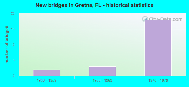
- New bridges - historical statistics
- 21950-1959
- 31960-1969
- 181970-1979


- Bridge Condition - Deck
- 36.4%Good
- 54.5%Satisfactory
- 9.1%Fair

- Bridge Condition - Superstructure
- 18.2%Very good
- 54.5%Good
- 18.2%Satisfactory
- 9.1%Fair

- Bridge Condition - Substructure
- 90.9%Good
- 9.1%Satisfactory

- Bridge Condition - Channel
- 33.3%Satisfactory
- 55.6%Fair
- 11.1%Poor

- Bridge Condition - Culverts
- 16.7%Satisfactory
- 50.0%Fair
- 16.7%Poor
- 16.7%Serious
Find on map >> Show street view
Structure Number: 500036, Location: 1.6 Mi South of US90/SR10 (Lat: 30.617347, Lng: -84.688861), Route carried "on" structure: County highway 268, Year Built: 1952, Status: Open, Structure Length: 0.95m (3.12ft), Average Daily Traffic: 1,900 (year 2020), Truck Traffic: 6%, Average Future Daily Traffic: 2,090 (year 2040), Design Load: H 15, Features Intersected: Telogia Creek
Minimum Vertical Clearance: 30+ m (98+ ft), Kilometerpoint: 15.839, Lanes on structure: 2, Owner: County Highway Agency, Approaching Roadway Width: 6.4m (21.0ft), Material/Design: Concrete, Design/Construction: Culvert, Number Of Spans In Main Unit: 3, Length of Maximum Span: 3.3m (10.8ft)
Condition: Channel: Fair, Culverts: Fair, Operating Rating: 37.2 metric tons, Method Used To Determine Operating Rating: Load Factor (LF), Inventory Rating: 21.8 metric tons, Method Used To Determine Inventory Rating: Load Factor (LF), Structural Evaluation: Somewhat better than minimum adequacy, Waterway Adequacy: Better than present minimum criteria, Approach Roadway Alignment: Equal to present desirable criteria, Designated Inspection Frequency: Every 24 months, Inspection Date: January 2022
Find on map >> Show street view
Structure Number: 500057, Location: 1.2 Miles West of CR 270 (Lat: 30.594072, Lng: -84.710508), Route carried "on" structure: County highway 270A, Year Built: 1958, Status: Open, Structure Length: 3.21m (10.53ft), Average Daily Traffic: 800 (year 2020), Truck Traffic: 6%, Average Future Daily Traffic: 880 (year 2040), Features Intersected: Telogia Creek
Minimum Vertical Clearance: 30+ m (98+ ft), Kilometerpoint: 14.270, Lanes on structure: 2, Owner: County Highway Agency, Approaching Roadway Width: 6.7m (22.0ft), Material/Design: Steel, Design/Construction: Culvert, Number Of Spans In Main Unit: 5, Length of Maximum Span: 6.5m (21.3ft)
Condition: Channel: Satisfactory, Culverts: Poor, Inventory Rating: 65.3 metric tons, Method Used To Determine Inventory Rating: Allowable Stress (AS), Structural Evaluation: Meets minimum limits, Waterway Adequacy: Better than present minimum criteria, Approach Roadway Alignment: Equal to present minimum criteria, Designated Inspection Frequency: Every 24 months, Underwater Inspection Frequency: Every 24 months, Other Special Inspection Frequency: Every 12 months, Inspection Date: January 2021, Underwater Inspection Date: January 2021, Other Special Inspection Date: January 2022
Find on map >> Show street view
Structure Number: 500058, Location: 0.2mi. West of CR274 (Lat: 30.557139, Lng: -84.637472), Route carried "on" structure: Interstate 10, Year Built: 1975, Status: Open, Structure Length: 0.86m (2.82ft), Average Daily Traffic: 22,500 (year 2020), Truck Traffic: 28%, Average Future Daily Traffic: 39,038 (year 2042), Design Load: HS 20+Mod, Features Intersected: Mill Dam
Minimum Vertical Clearance: 30+ m (98+ ft), Kilometerpoint: 29.279, Lanes on structure: 4, Base Highway Network: Yes, Owner: State Highway Agency, Approaching Roadway Width: 23.8m (78.1ft), Skew: 10 degrees, Material/Design: Concrete, Design/Construction: Culvert, Number Of Spans In Main Unit: 3, Length of Maximum Span: 2.7m (8.9ft)
Condition: Channel: Fair, Culverts: Fair, Structural Evaluation: Somewhat better than minimum adequacy, Waterway Adequacy: Equal to present desirable criteria, Approach Roadway Alignment: Equal to present desirable criteria, Designated Inspection Frequency: Every 24 months, Underwater Inspection Frequency: Every 24 months, Inspection Date: December 2021, Underwater Inspection Date: December 2021
Find on map >> Show street view
Structure Number: 500077, Location: 3.0mi. W of SR12 (Lat: 30.604136, Lng: -84.734675), Route carried "on" structure: Interstate 10, Year Built: 1976, Status: Open, Structure Length: 4.32m (14.17ft), Average Daily Traffic: 11,500 (year 2020), Truck Traffic: 33%, Average Future Daily Traffic: 19,952 (year 2042), Design Load: HL 93, Features Intersected: Apalachee North RR
Minimum Vertical Clearance: 30+ m (98+ ft), Kilometerpoint: 18.076, Lanes on structure: 2, Base Highway Network: Yes, Owner: State Highway Agency, Approaching Roadway Width: 11.6m (38.1ft), Material/Design: Prestressed concrete, Design/Construction: Stringer/Multi-beam, Number Of Spans In Main Unit: 3, Length of Maximum Span: 14.9m (48.9ft), Curb-To-Curb Width: 12.0m (39.4ft), Out-to-Out Width: 12.9m (42.3ft)
Condition: Deck: Good, Superstructure: Very good, Substructure: Good, Operating Rating: 51.3 metric tons, Method Used To Determine Operating Rating: Load and Resistance Factor (LRFR), Inventory Rating: 36.6 metric tons, Method Used To Determine Inventory Rating: Load and Resistance Factor (LRFR), Structural Evaluation: Better than present minimum criteria, Deck Geometry: Equal to present minimum criteria, Underclear: Superior to present desirable criteria, Approach Roadway Alignment: Equal to present desirable criteria, Designated Inspection Frequency: Every 24 months, Inspection Date: January 2022, Deck Structure Type: Concrete Cast-file-Place
Find on map >> Show street view
Structure Number: 500078, Location: 3.0mi. W of SR12 (Lat: 30.603894, Lng: -84.734708), Route carried "on" structure: Interstate 10, Year Built: 1976, Status: Open, Structure Length: 4.32m (14.17ft), Average Daily Traffic: 11,500 (year 2020), Truck Traffic: 33%, Average Future Daily Traffic: 19,952 (year 2042), Design Load: HL 93, Features Intersected: Apalachee North RR
Minimum Vertical Clearance: 30+ m (98+ ft), Kilometerpoint: 18.076, Lanes on structure: 2, Base Highway Network: Yes, Owner: State Highway Agency, Approaching Roadway Width: 11.6m (38.1ft), Material/Design: Prestressed concrete, Design/Construction: Stringer/Multi-beam, Number Of Spans In Main Unit: 3, Length of Maximum Span: 14.9m (48.9ft), Curb-To-Curb Width: 12.0m (39.4ft), Out-to-Out Width: 12.9m (42.3ft)
Condition: Deck: Good, Superstructure: Very good, Substructure: Good, Operating Rating: 51.3 metric tons, Method Used To Determine Operating Rating: Load and Resistance Factor (LRFR), Inventory Rating: 36.6 metric tons, Method Used To Determine Inventory Rating: Load and Resistance Factor (LRFR), Structural Evaluation: Better than present minimum criteria, Deck Geometry: Equal to present minimum criteria, Underclear: Equal to present minimum criteria, Approach Roadway Alignment: Equal to present desirable criteria, Designated Inspection Frequency: Every 24 months, Inspection Date: January 2022, Deck Structure Type: Concrete Cast-file-Place
Find on map >> Show street view
Structure Number: 50008, Location: 3.0 Mi West of SR12 (Lat: 30.604681, Lng: -84.736347), Route carried "on" structure: Interstate 10, Year Built: 1976, Status: Open, Structure Length: 4.40m (14.44ft), Average Daily Traffic: 11,500 (year 2020), Truck Traffic: 33%, Average Future Daily Traffic: 19,952 (year 2042), Design Load: HL 93, Features Intersected: CR268A
Minimum Vertical Clearance: 30+ m (98+ ft), Kilometerpoint: 17.910, Lanes on structure: 2, Lanes under structure: 2, Base Highway Network: Yes, Owner: State Highway Agency, Approaching Roadway Width: 11.6m (38.1ft), Skew: 2 degrees, Material/Design: Prestressed concrete, Design/Construction: Stringer/Multi-beam, Number Of Spans In Main Unit: 3, Length of Maximum Span: 17.0m (55.8ft), Curb-To-Curb Width: 12.0m (39.4ft), Out-to-Out Width: 12.9m (42.3ft)
Condition: Deck: Good, Superstructure: Good, Substructure: Good, Operating Rating: 41.2 metric tons, Method Used To Determine Operating Rating: Load and Resistance Factor (LRFR), Inventory Rating: 31.7 metric tons, Method Used To Determine Inventory Rating: Load and Resistance Factor (LRFR), Structural Evaluation: Better than present minimum criteria, Deck Geometry: Equal to present minimum criteria, Underclear: Equal to present minimum criteria, Approach Roadway Alignment: Equal to present desirable criteria, Length Of Structure Improvement: 4.34m (14.24ft), Designated Inspection Frequency: Every 24 months, Inspection Date: January 2022, Bridge Improvement Cost: $201,000, Total Project Cost: $201,000, Deck Structure Type: Concrete Cast-file-Place
Find on map >> Show street view
Structure Number: 500081, Location: 2.9 Mi West of SR12 (Lat: 30.604417, Lng: -84.736339), Route carried "on" structure: Interstate 10, Year Built: 1976, Status: Open, Structure Length: 4.40m (14.44ft), Average Daily Traffic: 11,500 (year 2020), Truck Traffic: 33%, Average Future Daily Traffic: 19,952 (year 2042), Design Load: HL 93, Features Intersected: CR268A
Minimum Vertical Clearance: 30+ m (98+ ft), Kilometerpoint: 17.910, Lanes on structure: 2, Lanes under structure: 2, Base Highway Network: Yes, Owner: State Highway Agency, Approaching Roadway Width: 11.6m (38.1ft), Skew: 2 degrees, Material/Design: Prestressed concrete, Design/Construction: Stringer/Multi-beam, Number Of Spans In Main Unit: 3, Length of Maximum Span: 17.0m (55.8ft), Curb-To-Curb Width: 12.0m (39.4ft), Out-to-Out Width: 12.9m (42.3ft)
Condition: Deck: Satisfactory, Superstructure: Good, Substructure: Good, Operating Rating: 41.2 metric tons, Method Used To Determine Operating Rating: Load and Resistance Factor (LRFR), Inventory Rating: 31.7 metric tons, Method Used To Determine Inventory Rating: Load and Resistance Factor (LRFR), Structural Evaluation: Better than present minimum criteria, Deck Geometry: Equal to present minimum criteria, Underclear: Equal to present minimum criteria, Approach Roadway Alignment: Equal to present desirable criteria, Length Of Structure Improvement: 4.34m (14.24ft), Designated Inspection Frequency: Every 24 months, Inspection Date: January 2022, Bridge Improvement Cost: $201,000, Total Project Cost: $201,000, Deck Structure Type: Concrete Cast-file-Place
Find on map >> Show street view
Structure Number: 500091, Location: 1.7mi. East of SR12 (Lat: 30.570408, Lng: -84.673328), Route carried "on" structure: State highway 65, Year Built: 1975, Status: Open, Structure Length: 7.64m (25.07ft), Average Daily Traffic: 2,400 (year 2020), Truck Traffic: 13%, Average Future Daily Traffic: 4,164 (year 2042), Design Load: HL 93, Features Intersected: I10 SR8
Minimum Vertical Clearance: 30+ m (98+ ft), Kilometerpoint: 14.394, Lanes on structure: 2, Lanes under structure: 4, Owner: State Highway Agency, Approaching Roadway Width: 9.8m (32.2ft), Skew: 1 degrees, Material/Design: Prestressed concrete, Design/Construction: Stringer/Multi-beam, Number Of Spans In Main Unit: 4, Length of Maximum Span: 27.6m (90.6ft), Curb-To-Curb Width: 13.4m (44.0ft), Out-to-Out Width: 14.1m (46.3ft)
Condition: Deck: Good, Superstructure: Good, Substructure: Good, Operating Rating: 52.6 metric tons, Method Used To Determine Operating Rating: Load and Resistance Factor (LRFR), Inventory Rating: 33.3 metric tons, Method Used To Determine Inventory Rating: Load and Resistance Factor (LRFR), Structural Evaluation: Better than present minimum criteria, Deck Geometry: Better than present minimum criteria, Underclear: Somewhat better than minimum adequacy, Approach Roadway Alignment: Equal to present desirable criteria, Designated Inspection Frequency: Every 24 months, Inspection Date: September 2021, Deck Structure Type: Concrete Cast-file-Place
Find on map >> Show street view
Structure Number: 500092, Location: 1.9 MI. West of SR12 (Lat: 30.595797, Lng: -84.724250), Route carried "on" structure: County highway C270A, Year Built: 1975, Status: Open, Structure Length: 10.15m (33.30ft), Average Daily Traffic: 800 (year 2020), Truck Traffic: 7%, Average Future Daily Traffic: 1,388 (year 2042), Design Load: HS 20+Mod, Features Intersected: I10 SR8, Facility Carried by Structure: CR270A
Minimum Vertical Clearance: 30+ m (98+ ft), Kilometerpoint: 12.867, Lanes on structure: 2, Lanes under structure: 4, Owner: State Highway Agency, Approaching Roadway Width: 7.3m (24.0ft), Skew: 4 degrees, Material/Design: Steel continuous, Design/Construction: Stringer/Multi-beam, Number Of Spans In Main Unit: 2, Number Of Approach Spans: 2, Length of Maximum Span: 37.2m (122.0ft), Curb-To-Curb Width: 13.4m (44.0ft), Out-to-Out Width: 14.1m (46.3ft)
Condition: Deck: Satisfactory, Superstructure: Satisfactory, Substructure: Good, Operating Rating: 38.7 metric tons, Method Used To Determine Operating Rating: Load Factor (LF), Inventory Rating: 23.2 metric tons, Method Used To Determine Inventory Rating: Load Factor (LF), Structural Evaluation: Equal to present minimum criteria, Deck Geometry: Superior to present desirable criteria, Underclear: Somewhat better than minimum adequacy, Approach Roadway Alignment: Equal to present desirable criteria, Designated Inspection Frequency: Every 24 months, Inspection Date: September 2021, Deck Structure Type: Concrete Cast-file-Place
Find on map >> Show street view
Structure Number: 500093, Location: 1.0MI W. of SR12 (Lat: 30.585150, Lng: -84.712919), Route carried "on" structure: Interstate 10, Year Built: 1975, Status: Open, Structure Length: 7.62m (25.00ft), Average Daily Traffic: 11,500 (year 2020), Truck Traffic: 33%, Average Future Daily Traffic: 19,952 (year 2042), Design Load: HS 20, Features Intersected: Telogia Creek
Minimum Vertical Clearance: 30+ m (98+ ft), Kilometerpoint: 21.023, Lanes on structure: 2, Base Highway Network: Yes, Owner: State Highway Agency, Approaching Roadway Width: 11.6m (38.1ft), Skew: 2 degrees, Material/Design: Prestressed concrete, Design/Construction: Stringer/Multi-beam, Number Of Spans In Main Unit: 5, Length of Maximum Span: 15.2m (49.9ft), Curb-To-Curb Width: 12.2m (40.0ft), Out-to-Out Width: 13.1m (43.0ft)
Condition: Deck: Satisfactory, Superstructure: Satisfactory, Substructure: Good, Channel: Satisfactory, Operating Rating: 74.4 metric tons, Method Used To Determine Operating Rating: Load Factor (LF), Inventory Rating: 44.5 metric tons, Method Used To Determine Inventory Rating: Load Factor (LF), Structural Evaluation: Equal to present minimum criteria, Deck Geometry: Better than present minimum criteria, Waterway Adequacy: Equal to present desirable criteria, Approach Roadway Alignment: Equal to present desirable criteria, Designated Inspection Frequency: Every 24 months, Inspection Date: September 2021, Deck Structure Type: Concrete Cast-file-Place
Find on map >> Show street view
Structure Number: 500094, Location: 1.0MI W. of SR12 (Lat: 30.584422, Lng: -84.713522), Route carried "on" structure: Interstate 10, Year Built: 1975, Status: Open, Structure Length: 7.62m (25.00ft), Average Daily Traffic: 11,500 (year 2020), Truck Traffic: 33%, Average Future Daily Traffic: 19,952 (year 2042), Design Load: HS 20, Features Intersected: Telogia Creek
Minimum Vertical Clearance: 30+ m (98+ ft), Kilometerpoint: 21.070, Lanes on structure: 2, Base Highway Network: Yes, Owner: State Highway Agency, Approaching Roadway Width: 11.6m (38.1ft), Skew: 2 degrees, Material/Design: Prestressed concrete, Design/Construction: Stringer/Multi-beam, Number Of Spans In Main Unit: 5, Length of Maximum Span: 15.2m (49.9ft), Curb-To-Curb Width: 12.2m (40.0ft), Out-to-Out Width: 13.1m (43.0ft)
Condition: Deck: Satisfactory, Superstructure: Good, Substructure: Good, Channel: Fair, Operating Rating: 74.4 metric tons, Method Used To Determine Operating Rating: Load Factor (LF), Inventory Rating: 44.5 metric tons, Method Used To Determine Inventory Rating: Load Factor (LF), Structural Evaluation: Better than present minimum criteria, Deck Geometry: Better than present minimum criteria, Waterway Adequacy: Equal to present desirable criteria, Approach Roadway Alignment: Equal to present desirable criteria, Designated Inspection Frequency: Every 24 months, Inspection Date: September 2021, Deck Structure Type: Concrete Cast-file-Place
Find on map >> Show street view
Structure Number: 500095, Location: 8.7 mi. East of CR270A (Lat: 30.578389, Lng: -84.699911), Route carried "on" structure: Interstate 10, Year Built: 1975, Status: Open, Structure Length: 6.40m (21.00ft), Average Daily Traffic: 11,250 (year 2020), Truck Traffic: 28%, Average Future Daily Traffic: 19,519 (year 2042), Design Load: HS 20, Features Intersected: SR12
Minimum Vertical Clearance: 30+ m (98+ ft), Kilometerpoint: 22.561, Lanes on structure: 2, Lanes under structure: 4, Base Highway Network: Yes, Owner: State Highway Agency, Approaching Roadway Width: 11.6m (38.1ft), Skew: 1 degrees, Material/Design: Prestressed concrete, Design/Construction: Stringer/Multi-beam, Number Of Spans In Main Unit: 2, Length of Maximum Span: 32.0m (105.0ft), Curb-To-Curb Width: 12.2m (40.0ft), Out-to-Out Width: 13.1m (43.0ft)
Condition: Deck: Satisfactory, Superstructure: Good, Substructure: Good, Inventory Rating: 82.6 metric tons, Method Used To Determine Inventory Rating: Load Factor (LF), Structural Evaluation: Better than present minimum criteria, Deck Geometry: Better than present minimum criteria, Underclear: Equal to present minimum criteria, Approach Roadway Alignment: Equal to present desirable criteria, Designated Inspection Frequency: Every 24 months, Inspection Date: December 2021, Deck Structure Type: Concrete Cast-file-Place
Find on map >> Show street view
Structure Number: 500096, Location: 6.9 mi. West of SR267 (Lat: 30.578169, Lng: -84.700050), Route carried "on" structure: Interstate 10, Year Built: 1975, Status: Open, Structure Length: 6.40m (21.00ft), Average Daily Traffic: 11,250 (year 2020), Truck Traffic: 28%, Average Future Daily Traffic: 19,519 (year 2042), Design Load: HS 20, Features Intersected: SR12
Minimum Vertical Clearance: 30+ m (98+ ft), Kilometerpoint: 22.561, Lanes on structure: 2, Lanes under structure: 4, Base Highway Network: Yes, Owner: State Highway Agency, Approaching Roadway Width: 11.6m (38.1ft), Skew: 1 degrees, Material/Design: Prestressed concrete, Design/Construction: Stringer/Multi-beam, Number Of Spans In Main Unit: 2, Length of Maximum Span: 32.0m (105.0ft), Curb-To-Curb Width: 12.2m (40.0ft), Out-to-Out Width: 13.1m (43.0ft)
Condition: Deck: Satisfactory, Superstructure: Good, Substructure: Good, Inventory Rating: 82.6 metric tons, Method Used To Determine Inventory Rating: Load Factor (LF), Structural Evaluation: Better than present minimum criteria, Deck Geometry: Better than present minimum criteria, Underclear: Equal to present minimum criteria, Approach Roadway Alignment: Equal to present desirable criteria, Designated Inspection Frequency: Every 24 months, Inspection Date: December 2021, Deck Structure Type: Concrete Cast-file-Place
Find on map >> Show street view
Structure Number: 500105, Location: 0.5Mi. E OF SR12 (Lat: 30.573833, Lng: -84.686444), Route carried "on" structure: Interstate 10, Year Built: 1972, Status: Open, Structure Length: 1.08m (3.54ft), Average Daily Traffic: 22,500 (year 2020), Truck Traffic: 28%, Average Future Daily Traffic: 39,038 (year 2042), Design Load: HS 20, Features Intersected: Little Telogia Ck
Minimum Vertical Clearance: 30+ m (98+ ft), Kilometerpoint: 23.913, Lanes on structure: 4, Base Highway Network: Yes, Owner: State Highway Agency, Approaching Roadway Width: 23.2m (76.1ft), Skew: 11 degrees, Material/Design: Concrete, Design/Construction: Culvert, Number Of Spans In Main Unit: 3, Length of Maximum Span: 3.4m (11.2ft)
Condition: Channel: Satisfactory, Culverts: Satisfactory, Inventory Rating: 67.1 metric tons, Method Used To Determine Inventory Rating: Load Factor (LF), Structural Evaluation: Equal to present minimum criteria, Waterway Adequacy: Better than present minimum criteria, Approach Roadway Alignment: Equal to present desirable criteria, Designated Inspection Frequency: Every 24 months, Inspection Date: Febuary 2020
Find on map >> Show street view
Structure Number: 504024, Location: 0.32 Miles West of CR 274 (Lat: 30.562028, Lng: -84.637417), Route carried "on" structure: Other road , Year Built: 1960, Status: Posted for load, Structure Length: 0.87m (2.85ft), Average Daily Traffic: 59 (year 2020), Average Future Daily Traffic: 65 (year 2040), Features Intersected: Mill Dam Creek, Facility Carried by Structure: Charles Brown Lane
Minimum Vertical Clearance: 30+ m (98+ ft), Kilometerpoint: 0.724, Lanes on structure: 2, Owner: County Highway Agency, Approaching Roadway Width: 5.6m (18.4ft), Material/Design: Steel, Design/Construction: Stringer/Multi-beam, Number Of Spans In Main Unit: 1, Length of Maximum Span: 8.7m (28.5ft), Curb or Sidewalk Widths: Left: 0.1m (0.3ft), Right: 0.1m (0.3ft), Curb-To-Curb Width: 6.1m (20.0ft), Out-to-Out Width: 6.9m (22.6ft)
Condition: Deck: Fair, Superstructure: Fair, Substructure: Satisfactory, Channel: Poor, Operating Rating: 22.7 metric tons, Method Used To Determine Operating Rating: Load and Resistance Factor (LRFR), Inventory Rating: 18.1 metric tons, Method Used To Determine Inventory Rating: Load and Resistance Factor (LRFR), Structural Evaluation: Somewhat better than minimum adequacy, Deck Geometry: Somewhat better than minimum adequacy, Waterway Adequacy: Equal to present desirable criteria, Approach Roadway Alignment: Equal to present desirable criteria, Bridge Posting: Required (Relationship of Operating Rating to Maximum Legal Load: 30.0 - 39.9% below), Designated Inspection Frequency: Every 24 months, Other Special Inspection Frequency: Every 12 months, Inspection Date: January 2022, Other Special Inspection Date: January 2022, Deck Structure Type: Concrete Cast-file-Place
Find on map >> Show street view
Structure Number: 504039, Location: 0.9 Miles South of CR 268 (Lat: 30.630333, Lng: -84.766556), Route carried "on" structure: Other road , Year Built: 1960, Status: Open, Structure Length: 0.97m (3.18ft), Average Daily Traffic: 39 (year 2020), Average Future Daily Traffic: 43 (year 2040), Features Intersected: Unnamed Branch, Facility Carried by Structure: Hardaway Road No 2
Minimum Vertical Clearance: 30+ m (98+ ft), Kilometerpoint: 1.444, Lanes on structure: 2, Owner: County Highway Agency, Approaching Roadway Width: 6.1m (20.0ft), Material/Design: Steel, Design/Construction: Culvert, Number Of Spans In Main Unit: 2, Length of Maximum Span: 4.8m (15.7ft)
Condition: Channel: Fair, Culverts: Fair, Inventory Rating: 78.0 metric tons, Method Used To Determine Inventory Rating: Allowable Stress (AS), Structural Evaluation: Somewhat better than minimum adequacy, Waterway Adequacy: Better than present minimum criteria, Approach Roadway Alignment: Equal to present desirable criteria, Designated Inspection Frequency: Every 24 months, Inspection Date: January 2022
Find on map >> Show street view
Structure Number: 504043, Location: 0.8 Miles West of CR 270 (Lat: 30.603694, Lng: -84.701656), Route carried "on" structure: County highway , Year Built: 1960, Status: Open, Structure Length: 1.92m (6.30ft), Average Daily Traffic: 99 (year 2020), Average Future Daily Traffic: 109 (year 2040), Features Intersected: Hannas Mill Pond, Facility Carried by Structure: Hanna Mill Pond Rd
Minimum Vertical Clearance: 30+ m (98+ ft), Kilometerpoint: 3.640, Lanes on structure: 2, Owner: County Highway Agency, Approaching Roadway Width: 6.2m (20.3ft), Material/Design: Steel, Design/Construction: Culvert, Number Of Spans In Main Unit: 3, Length of Maximum Span: 6.6m (21.7ft)
Condition: Channel: Fair, Culverts: Serious, Operating Rating: 66.2 metric tons, Method Used To Determine Operating Rating: Allowable Stress (AS), Inventory Rating: 39.0 metric tons, Method Used To Determine Inventory Rating: Allowable Stress (AS), Structural Evaluation: High priority of corrective action, Waterway Adequacy: Equal to present desirable criteria, Approach Roadway Alignment: Equal to present desirable criteria, Designated Inspection Frequency: Every 24 months, Other Special Inspection Frequency: Every 6 months, Inspection Date: December 2021, Other Special Inspection Date: December 2021
Find on map >> Show street view
Structure Number: 50008, Location: 3.0 Mi West of SR12 (Lat: 30.604681, Lng: -84.736347), Route carried "under" structure: County highway 268A, Year Built: 1976, Structure Length: 0. m, Average Daily Traffic: 463 (year 1999), Truck Traffic: 6%, Features Intersected: CR268A, Facility Carried by Structure: I10 SR8
Minimum Vertical Clearance: 4.57m (14.99ft), Kilometerpoint: 0.071, Lanes on structure: 2, Lanes under structure: 2, Material/Design: Prestressed concrete, Design/Construction: Stringer/Multi-beam, Length of Maximum Span: 17.0m (55.8ft)
Find on map >> Show street view
Structure Number: 500081, Location: 2.9 Mi West of SR12 (Lat: 30.604417, Lng: -84.736339), Route carried "under" structure: County highway 268A, Year Built: 1976, Structure Length: 0. m, Average Daily Traffic: 520 (year 1999), Truck Traffic: 7%, Features Intersected: CR268A, Facility Carried by Structure: I10 SR8
Minimum Vertical Clearance: 4.57m (14.99ft), Kilometerpoint: 0.042, Lanes on structure: 2, Lanes under structure: 2, Material/Design: Prestressed concrete, Design/Construction: Stringer/Multi-beam, Length of Maximum Span: 17.0m (55.8ft)
Find on map >> Show street view
Structure Number: 500091, Location: 1.7mi. East of SR12 (Lat: 30.570408, Lng: -84.673328), Route carried "under" structure: Interstate 10, Year Built: 1975, Structure Length: 0. m, Average Daily Traffic: 22,500 (year 2020), Truck Traffic: 28%, Features Intersected: I10 SR8, Facility Carried by Structure: SR65 Hosford Hwy
Minimum Vertical Clearance: 4.94m (16.21ft), Kilometerpoint: 25.292, Lanes on structure: 2, Lanes under structure: 4, Material/Design: Prestressed concrete, Design/Construction: Stringer/Multi-beam, Length of Maximum Span: 27.6m (90.6ft)
Find on map >> Show street view
Structure Number: 500092, Location: 1.9 MI. West of SR12 (Lat: 30.595797, Lng: -84.724250), Route carried "under" structure: Interstate 10, Year Built: 1975, Structure Length: 0. m, Average Daily Traffic: 23,000 (year 2020), Truck Traffic: 33%, Features Intersected: I10 SR8, Facility Carried by Structure: CR270A
Minimum Vertical Clearance: 4.91m (16.11ft), Kilometerpoint: 19.462, Lanes on structure: 2, Lanes under structure: 4, Material/Design: Steel continuous, Design/Construction: Stringer/Multi-beam, Length of Maximum Span: 37.2m (122.0ft)
Find on map >> Show street view
Structure Number: 500095, Location: 8.7 mi. East of CR270A (Lat: 30.578389, Lng: -84.699911), Route carried "under" structure: State highway 12, Year Built: 1975, Structure Length: 0. m, Average Daily Traffic: 3,700 (year 2020), Truck Traffic: 13%, Features Intersected: SR12, Facility Carried by Structure: I10 SR8
Minimum Vertical Clearance: 4.88m (16.01ft), Kilometerpoint: 14.338, Lanes on structure: 2, Lanes under structure: 4, Material/Design: Prestressed concrete, Design/Construction: Stringer/Multi-beam, Length of Maximum Span: 32.0m (105.0ft)
Find on map >> Show street view
Structure Number: 500096, Location: 6.9 mi. West of SR267 (Lat: 30.578169, Lng: -84.700050), Route carried "under" structure: State highway 12, Year Built: 1975, Structure Length: 0. m, Average Daily Traffic: 3,700 (year 2020), Truck Traffic: 13%, Features Intersected: SR12, Facility Carried by Structure: I10 SR8
Minimum Vertical Clearance: 4.88m (16.01ft), Kilometerpoint: 14.367, Lanes on structure: 2, Lanes under structure: 4, Material/Design: Prestressed concrete, Design/Construction: Stringer/Multi-beam, Length of Maximum Span: 32.0m (105.0ft)