Bridge Statistics for Gregory, Texas (TX)
Condition, Traffic, Stress, Structural Evaluation, Project Costs
- National Bridge Inventory (NBI) Statistics
- 30Number of bridges
- 732ft / 223mTotal length
- $147,000Total costs
- 218,225Total average daily traffic
- 24,659Total average daily truck traffic
- National Bridge Inventory (NBI) Registered Bridges for Gregory
- No street view available for this location
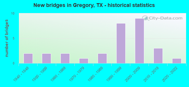
- New bridges - historical statistics
- 21940-1949
- 21950-1959
- 21960-1969
- 11970-1979
- 21980-1989
- 81990-1999
- 92000-2009
- 32010-2019
- 12020-2022

- Reconstructed bridges - Historical Statistics
- 21960-1969
- 01970-1979
- 01980-1989
- 01990-1999
- 12000-2009


- Bridge Condition - Deck
- 78.6%Good
- 21.4%Satisfactory

- Bridge Condition - Superstructure
- 21.4%Very good
- 71.4%Good
- 7.1%Satisfactory

- Bridge Condition - Substructure
- 71.4%Good
- 21.4%Satisfactory
- 7.1%Poor

- Bridge Condition - Channel
- 45.5%Good
- 54.5%Satisfactory
Find on map >> Show street view
Structure Number: 162050010104011, Location: 1.35 MI N OF FM 3239 (Lat: 27.914400, Lng: -97.298056), Route carried "on" structure: US 181, Year Built: 2008, Status: Open, Structure Length: 1.16m (3.81ft), Average Daily Traffic: 4,000 (year 2009), Truck Traffic: 11%, Average Future Daily Traffic: 5,100 (year 2029), Design Load: HS 20, Features Intersected: DRAINAGE DITCH
Minimum Vertical Clearance: 30+ m (98+ ft), Kilometerpoint: 38.640, Lanes on structure: 2, Owner: State Highway Agency, Approaching Roadway Width: 10.4m (34.1ft), Skew: 3 degrees, Material/Design: Concrete, Design/Construction: Culvert, Number Of Spans In Main Unit: 3, Length of Maximum Span: 3.0m (9.8ft), Curb-To-Curb Width: 10.5m (34.4ft), Out-to-Out Width: 21.1m (69.2ft)
Condition: Channel: Good, Culverts: Good, Operating Rating: 44.4 metric tons, Method Used To Determine Operating Rating: No rating analysis performed, Inventory Rating: 32.7 metric tons, Method Used To Determine Inventory Rating: No rating analysis performed, Structural Evaluation: Better than present minimum criteria, Deck Geometry: Somewhat better than minimum adequacy, Waterway Adequacy: Superior to present desirable criteria, Approach Roadway Alignment: Equal to present desirable criteria, Designated Inspection Frequency: Every 48 months, Inspection Date: April 2018, Deck Structure Type: Concrete Cast-file-Place, Wearing Surface/Protective System: Wearing Surface: Bituminous
Find on map >> Show street view
Structure Number: 162050010104031, Location: 1.9 MI NW OF FM 2986 (Lat: 27.943292, Lng: -97.330567), Route carried "on" structure: US 181, Year Built: 1942, Year Reconstructed: 1967, Status: Open, Structure Length: 2.44m (8.01ft), Average Daily Traffic: 4,342 (year 2020), Truck Traffic: 22%, Average Future Daily Traffic: 5,200 (year 2033), Design Load: H 15, Features Intersected: MUSTANG MOTT DITCH
Minimum Vertical Clearance: 30+ m (98+ ft), Kilometerpoint: 33.478, Lanes on structure: 2, Owner: State Highway Agency, Approaching Roadway Width: 11.6m (38.1ft), Material/Design: Concrete, Design/Construction: Slab, Number Of Spans In Main Unit: 4, Length of Maximum Span: 6.1m (20.0ft), Curb-To-Curb Width: 12.2m (40.0ft), Out-to-Out Width: 12.9m (42.3ft)
Condition: Deck: Good, Superstructure: Good, Substructure: Poor, Channel: Satisfactory, Operating Rating: 36.3 metric tons, Method Used To Determine Operating Rating: Load Factor (LF), Inventory Rating: 21.8 metric tons, Method Used To Determine Inventory Rating: Load Factor (LF), Structural Evaluation: Meets minimum limits, Deck Geometry: Better than present minimum criteria, Waterway Adequacy: Equal to present minimum criteria, Approach Roadway Alignment: Equal to present desirable criteria, Designated Inspection Frequency: Every 24 months, Inspection Date: April 2020, Deck Structure Type: Concrete Cast-file-Place, Wearing Surface/Protective System: Wearing Surface: Bituminous
Find on map >> Show street view
Structure Number: 162050010104032, Location: 1.2 MI NW OF FM 2986 (Lat: 27.938453, Lng: -97.321317), Route carried "on" structure: US 181, Year Built: 1941, Year Reconstructed: 1967, Status: Open, Structure Length: 1.01m (3.31ft), Average Daily Traffic: 4,342 (year 2020), Truck Traffic: 22%, Average Future Daily Traffic: 5,200 (year 2033), Design Load: H 15, Features Intersected: MCKAMEY SWALE
Minimum Vertical Clearance: 30+ m (98+ ft), Kilometerpoint: 34.524, Lanes on structure: 2, Base Highway Network: Yes, Owner: State Highway Agency, Approaching Roadway Width: 11.0m (36.1ft), Material/Design: Concrete, Design/Construction: Culvert, Number Of Spans In Main Unit: 6, Length of Maximum Span: 1.5m (4.9ft), Curb-To-Curb Width: 13.9m (45.6ft), Out-to-Out Width: 14.6m (47.9ft)
Condition: Channel: Good, Culverts: Good, Operating Rating: 39.9 metric tons, Method Used To Determine Operating Rating: Load Factor (LF), Inventory Rating: 23.6 metric tons, Method Used To Determine Inventory Rating: Load Factor (LF), Structural Evaluation: Equal to present minimum criteria, Deck Geometry: Superior to present desirable criteria, Waterway Adequacy: Equal to present minimum criteria, Approach Roadway Alignment: Equal to present desirable criteria, Designated Inspection Frequency: Every 24 months, Inspection Date: January 2022, Deck Structure Type: Concrete Cast-file-Place, Wearing Surface/Protective System: Wearing Surface: Bituminous
Find on map >> Show street view
Structure Number: 162050010104035, Location: 0.7 MI S OF FM 2986 (Lat: 27.921792, Lng: -97.298094), Route carried "on" structure: US 181, Year Built: 1952, Year Reconstructed: 2005, Status: Open, Structure Length: 1.07m (3.51ft), Average Daily Traffic: 8,622 (year 2020), Truck Traffic: 15%, Average Future Daily Traffic: 11,220 (year 2033), Design Load: HS 20, Features Intersected: DRAINAGE DITCH
Minimum Vertical Clearance: 30+ m (98+ ft), Kilometerpoint: 37.713, Lanes on structure: 5, Base Highway Network: Yes, Owner: State Highway Agency, Approaching Roadway Width: 33.2m (108.9ft), Skew: 24 degrees, Material/Design: Concrete, Design/Construction: Culvert, Number Of Spans In Main Unit: 4, Length of Maximum Span: 1.5m (4.9ft), Curb-To-Curb Width: 35.2m (115.5ft), Out-to-Out Width: 88.0m (288.7ft)
Condition: Channel: Satisfactory, Culverts: Good, Operating Rating: 39.9 metric tons, Method Used To Determine Operating Rating: Load Factor (LF), Inventory Rating: 23.6 metric tons, Method Used To Determine Inventory Rating: Load Factor (LF), Structural Evaluation: Somewhat better than minimum adequacy, Deck Geometry: Superior to present desirable criteria, Waterway Adequacy: Equal to present minimum criteria, Approach Roadway Alignment: Equal to present desirable criteria, Designated Inspection Frequency: Every 24 months, Inspection Date: April 2020, Deck Structure Type: Concrete Cast-file-Place, Wearing Surface/Protective System: Wearing Surface: Bituminous
Find on map >> Show street view
Structure Number: 162050010104037, Location: 1.23 MI NE OF FM 3239 (Lat: 27.912689, Lng: -97.296744), Route carried "on" structure: US 181, Year Built: 1952, Status: Open, Structure Length: 2.32m (7.61ft), Average Daily Traffic: 43,652 (year 2020), Truck Traffic: 6%, Average Future Daily Traffic: 27,350 (year 2033), Design Load: H 20, Features Intersected: DRAINAGE DITCH
Minimum Vertical Clearance: 30+ m (98+ ft), Kilometerpoint: 38.722, Lanes on structure: 2, Base Highway Network: Yes, Owner: State Highway Agency, Approaching Roadway Width: 11.6m (38.1ft), Skew: 3 degrees, Material/Design: Concrete, Design/Construction: Slab, Number Of Spans In Main Unit: 3, Length of Maximum Span: 7.6m (24.9ft), Curb-To-Curb Width: 11.9m (39.0ft), Out-to-Out Width: 12.8m (42.0ft)
Condition: Deck: Satisfactory, Superstructure: Satisfactory, Substructure: Satisfactory, Channel: Satisfactory, Operating Rating: 37.2 metric tons, Method Used To Determine Operating Rating: Load Factor (LF), Inventory Rating: 22.7 metric tons, Method Used To Determine Inventory Rating: Load Factor (LF), Structural Evaluation: Somewhat better than minimum adequacy, Deck Geometry: Equal to present minimum criteria, Waterway Adequacy: Equal to present minimum criteria, Approach Roadway Alignment: Equal to present desirable criteria, Designated Inspection Frequency: Every 24 months, Inspection Date: April 2020, Deck Structure Type: Concrete Cast-file-Place, Wearing Surface/Protective System: Wearing Surface: Bituminous
Find on map >> Show street view
Structure Number: 162050010104052, Location: 1.85 MI NW OF FM 2986 (Lat: 27.943447, Lng: -97.330458), Route carried "on" structure: US 181, Year Built: 1967, Status: Open, Structure Length: 2.77m (9.09ft), Average Daily Traffic: 4,068 (year 2020), Truck Traffic: 22%, Average Future Daily Traffic: 5,200 (year 2033), Design Load: H 20, Features Intersected: MUSTANG MOTT DITCH
Minimum Vertical Clearance: 30+ m (98+ ft), Kilometerpoint: 33.478, Lanes on structure: 2, Owner: State Highway Agency, Approaching Roadway Width: 11.6m (38.1ft), Material/Design: Concrete, Design/Construction: Stringer/Multi-beam, Number Of Spans In Main Unit: 3, Length of Maximum Span: 9.1m (29.9ft), Curb-To-Curb Width: 12.1m (39.7ft), Out-to-Out Width: 12.9m (42.3ft)
Condition: Deck: Good, Superstructure: Good, Substructure: Satisfactory, Channel: Satisfactory, Operating Rating: 58.0 metric tons, Method Used To Determine Operating Rating: Load Factor (LF), Inventory Rating: 34.5 metric tons, Method Used To Determine Inventory Rating: Load Factor (LF), Structural Evaluation: Equal to present minimum criteria, Deck Geometry: Better than present minimum criteria, Waterway Adequacy: Equal to present minimum criteria, Approach Roadway Alignment: Equal to present desirable criteria, Designated Inspection Frequency: Every 24 months, Inspection Date: April 2020, Deck Structure Type: Concrete Cast-file-Place, Wearing Surface/Protective System: Wearing Surface: Bituminous
Find on map >> Show street view
Structure Number: 162050010104053, Location: 1.2 MI NW OF FM 2986 (Lat: 27.938611, Lng: -97.321225), Route carried "on" structure: US 181, Year Built: 1967, Status: Open, Structure Length: 1.01m (3.31ft), Average Daily Traffic: 4,068 (year 2020), Truck Traffic: 22%, Average Future Daily Traffic: 5,200 (year 2033), Design Load: HS 20, Features Intersected: MCKAMEY SWALE
Minimum Vertical Clearance: 30+ m (98+ ft), Kilometerpoint: 34.524, Lanes on structure: 2, Base Highway Network: Yes, Owner: State Highway Agency, Approaching Roadway Width: 11.6m (38.1ft), Material/Design: Concrete, Design/Construction: Culvert, Number Of Spans In Main Unit: 6, Length of Maximum Span: 1.5m (4.9ft), Curb-To-Curb Width: 13.1m (43.0ft), Out-to-Out Width: 13.8m (45.3ft)
Condition: Channel: Good, Culverts: Good, Operating Rating: 39.9 metric tons, Method Used To Determine Operating Rating: Load Factor (LF), Inventory Rating: 23.6 metric tons, Method Used To Determine Inventory Rating: Load Factor (LF), Structural Evaluation: Equal to present minimum criteria, Deck Geometry: Superior to present desirable criteria, Waterway Adequacy: Equal to present minimum criteria, Approach Roadway Alignment: Equal to present desirable criteria, Designated Inspection Frequency: Every 24 months, Inspection Date: January 2022, Deck Structure Type: Concrete Cast-file-Place, Wearing Surface/Protective System: Wearing Surface: Bituminous
Find on map >> Show street view
Structure Number: 162050010104058, Location: 1.3 MI N OF FM 3239 (Lat: 27.914258, Lng: -97.296411), Route carried "on" structure: State highway 35, Year Built: 1981, Status: Posted for load, Structure Length: 42.64m (139.90ft), Average Daily Traffic: 17,069 (year 2014), Truck Traffic: 14%, Average Future Daily Traffic: 21,940 (year 2033), Design Load: HS 20, Features Intersected: US 181 NB & UP RR
Minimum Vertical Clearance: 30+ m (98+ ft), Kilometerpoint: 16.206, Lanes on structure: 2, Lanes under structure: 5, Base Highway Network: Yes, Owner: State Highway Agency, Approaching Roadway Width: 11.6m (38.1ft), Skew: 9 degrees, Material/Design: Prestressed concrete, Design/Construction: Stringer/Multi-beam, Number Of Spans In Main Unit: 13, Number Of Approach Spans: 1, Length of Maximum Span: 33.8m (110.9ft), Curb-To-Curb Width: 11.4m (37.4ft), Out-to-Out Width: 12.2m (40.0ft)
Condition: Deck: Satisfactory, Superstructure: Good, Substructure: Good, Channel: Satisfactory, Operating Rating: 54.4 metric tons, Method Used To Determine Operating Rating: Assigned rating based on Load Factor Design (LFD) reported in metric tons, Inventory Rating: 32.7 metric tons, Method Used To Determine Inventory Rating: Assigned rating based on Load Factor Design (LFD) reported in metric tons, Structural Evaluation: Better than present minimum criteria, Deck Geometry: Somewhat better than minimum adequacy, Underclear: Superior to present desirable criteria, Waterway Adequacy: Superior to present desirable criteria, Approach Roadway Alignment: Equal to present desirable criteria, Length Of Structure Improvement: 42.64m (139.90ft), Designated Inspection Frequency: Every 24 months, Inspection Date: April 2020, Deck Structure Type: Concrete Cast-file-Place
Find on map >> Show street view
Structure Number: 162050010104067, Location: 1.3 MI N OF FM 3239 (Lat: 27.913106, Lng: -97.297411), Route carried "on" structure: State highway 35, Year Built: 1994, Status: Open, Structure Length: 41.91m (137.50ft), Average Daily Traffic: 16,454 (year 2014), Truck Traffic: 14%, Average Future Daily Traffic: 21,940 (year 2033), Design Load: HS 20, Features Intersected: US 181 NB & UP RR
Minimum Vertical Clearance: 30+ m (98+ ft), Kilometerpoint: 18.025, Lanes on structure: 2, Lanes under structure: 5, Base Highway Network: Yes, Owner: State Highway Agency, Approaching Roadway Width: 11.6m (38.1ft), Skew: 9 degrees, Material/Design: Prestressed concrete, Design/Construction: Stringer/Multi-beam, Number Of Spans In Main Unit: 9, Number Of Approach Spans: 6, Length of Maximum Span: 33.5m (109.9ft), Curb-To-Curb Width: 11.3m (37.1ft), Out-to-Out Width: 54.9m (180.1ft)
Condition: Deck: Satisfactory, Superstructure: Good, Substructure: Good, Channel: Satisfactory, Operating Rating: 54.4 metric tons, Method Used To Determine Operating Rating: Assigned rating based on Load Factor Design (LFD) reported in metric tons, Inventory Rating: 32.7 metric tons, Method Used To Determine Inventory Rating: Assigned rating based on Load Factor Design (LFD) reported in metric tons, Structural Evaluation: Better than present minimum criteria, Deck Geometry: Somewhat better than minimum adequacy, Underclear: Equal to present minimum criteria, Waterway Adequacy: Superior to present desirable criteria, Approach Roadway Alignment: Equal to present desirable criteria, Designated Inspection Frequency: Every 24 months, Inspection Date: April 2020, Deck Structure Type: Concrete Precast Panels
Find on map >> Show street view
Structure Number: 162050010104075, Location: 2.35 MI N OF FM 3239 (Lat: 27.928264, Lng: -97.301431), Route carried "on" structure: US 181, Year Built: 2008, Status: Open, Structure Length: 10.97m (35.99ft), Average Daily Traffic: 4,174 (year 2020), Truck Traffic: 22%, Average Future Daily Traffic: 5,200 (year 2033), Design Load: HS 25 or greater, Features Intersected: SP 202 EB & UPRR
Minimum Vertical Clearance: 30+ m (98+ ft), Kilometerpoint: 36.909, Lanes on structure: 2, Lanes under structure: 3, Base Highway Network: Yes, Owner: State Highway Agency, Approaching Roadway Width: 11.6m (38.1ft), Skew: 4 degrees, Material/Design: Prestressed concrete, Design/Construction: Stringer/Multi-beam, Number Of Spans In Main Unit: 3, Length of Maximum Span: 36.6m (120.1ft), Curb-To-Curb Width: 12.0m (39.4ft), Out-to-Out Width: 12.9m (42.3ft)
Condition: Deck: Good, Superstructure: Very good, Substructure: Good, Operating Rating: 68.0 metric tons, Method Used To Determine Operating Rating: Assigned rating based on Load Factor Design (LFD) reported in metric tons, Inventory Rating: 40.8 metric tons, Method Used To Determine Inventory Rating: Assigned rating based on Load Factor Design (LFD) reported in metric tons, Structural Evaluation: Better than present minimum criteria, Deck Geometry: Better than present minimum criteria, Underclear: Superior to present desirable criteria, Approach Roadway Alignment: Equal to present desirable criteria, Designated Inspection Frequency: Every 24 months, Inspection Date: April 2020, Deck Structure Type: Concrete Precast Panels
Find on map >> Show street view
Structure Number: 162050010104076, Location: 2.35 MI N OF FM 3239 (Lat: 27.927197, Lng: -97.300597), Route carried "on" structure: US 181, Year Built: 2008, Status: Open, Structure Length: 10.97m (35.99ft), Average Daily Traffic: 4,449 (year 2020), Truck Traffic: 22%, Average Future Daily Traffic: 5,200 (year 2033), Design Load: HS 25 or greater, Features Intersected: SP 202 EB & UPRR
Minimum Vertical Clearance: 30+ m (98+ ft), Kilometerpoint: 36.909, Lanes on structure: 2, Lanes under structure: 3, Base Highway Network: Yes, Owner: State Highway Agency, Approaching Roadway Width: 11.6m (38.1ft), Skew: 4 degrees, Material/Design: Prestressed concrete, Design/Construction: Stringer/Multi-beam, Number Of Spans In Main Unit: 3, Length of Maximum Span: 36.6m (120.1ft), Curb-To-Curb Width: 11.5m (37.7ft), Out-to-Out Width: 12.2m (40.0ft)
Condition: Deck: Good, Superstructure: Good, Substructure: Good, Operating Rating: 68.0 metric tons, Method Used To Determine Operating Rating: Assigned rating based on Load Factor Design (LFD) reported in metric tons, Inventory Rating: 40.8 metric tons, Method Used To Determine Inventory Rating: Assigned rating based on Load Factor Design (LFD) reported in metric tons, Structural Evaluation: Better than present minimum criteria, Deck Geometry: Equal to present minimum criteria, Underclear: Superior to present desirable criteria, Approach Roadway Alignment: Equal to present desirable criteria, Designated Inspection Frequency: Every 24 months, Inspection Date: April 2020, Deck Structure Type: Concrete Precast Panels
Find on map >> Show street view
Structure Number: 162050010104077, Location: 2.55 MI N OF FM 3239 (Lat: 27.931475, Lng: -97.303519), Route carried "on" structure: US 181, Year Built: 2008, Status: Open, Structure Length: 7.32m (24.02ft), Average Daily Traffic: 3,161 (year 2020), Truck Traffic: 22%, Average Future Daily Traffic: 5,200 (year 2033), Design Load: HS 25 or greater, Features Intersected: FM 2986
Minimum Vertical Clearance: 30+ m (98+ ft), Kilometerpoint: 36.484, Lanes on structure: 2, Lanes under structure: 4, Base Highway Network: Yes, Owner: State Highway Agency, Approaching Roadway Width: 11.6m (38.1ft), Material/Design: Prestressed concrete, Design/Construction: Stringer/Multi-beam, Number Of Spans In Main Unit: 3, Length of Maximum Span: 24.4m (80.1ft), Curb-To-Curb Width: 11.4m (37.4ft), Out-to-Out Width: 12.2m (40.0ft)
Condition: Deck: Good, Superstructure: Good, Substructure: Good, Operating Rating: 68.0 metric tons, Method Used To Determine Operating Rating: Assigned rating based on Load Factor Design (LFD) reported in metric tons, Inventory Rating: 40.8 metric tons, Method Used To Determine Inventory Rating: Assigned rating based on Load Factor Design (LFD) reported in metric tons, Structural Evaluation: Better than present minimum criteria, Deck Geometry: Equal to present minimum criteria, Underclear: Superior to present desirable criteria, Approach Roadway Alignment: Equal to present desirable criteria, Designated Inspection Frequency: Every 24 months, Inspection Date: April 2020, Deck Structure Type: Concrete Precast Panels
Find on map >> Show street view
Structure Number: 162050010104078, Location: 2.55 MI N OF FM 3239 (Lat: 27.931247, Lng: -97.302767), Route carried "on" structure: US 181, Year Built: 2008, Status: Open, Structure Length: 7.32m (24.02ft), Average Daily Traffic: 2,906 (year 2020), Truck Traffic: 22%, Average Future Daily Traffic: 5,200 (year 2033), Design Load: HS 25 or greater, Features Intersected: FM 2986
Minimum Vertical Clearance: 30+ m (98+ ft), Kilometerpoint: 36.484, Lanes on structure: 2, Lanes under structure: 4, Base Highway Network: Yes, Owner: State Highway Agency, Approaching Roadway Width: 11.6m (38.1ft), Material/Design: Prestressed concrete, Design/Construction: Stringer/Multi-beam, Number Of Spans In Main Unit: 3, Length of Maximum Span: 24.4m (80.1ft), Curb-To-Curb Width: 11.4m (37.4ft), Out-to-Out Width: 12.2m (40.0ft)
Condition: Deck: Good, Superstructure: Good, Substructure: Good, Operating Rating: 68.0 metric tons, Method Used To Determine Operating Rating: Assigned rating based on Load Factor Design (LFD) reported in metric tons, Inventory Rating: 40.8 metric tons, Method Used To Determine Inventory Rating: Assigned rating based on Load Factor Design (LFD) reported in metric tons, Structural Evaluation: Better than present minimum criteria, Deck Geometry: Equal to present minimum criteria, Underclear: Superior to present desirable criteria, Approach Roadway Alignment: Equal to present desirable criteria, Designated Inspection Frequency: Every 24 months, Inspection Date: April 2020, Deck Structure Type: Concrete Precast Panels
Find on map >> Show street view
Structure Number: 162050018006051, Location: 0.9 MI S OF FM 136 (Lat: 27.916608, Lng: -97.281158), Route carried "on" structure: State highway 35, Year Built: 1994, Status: Open, Structure Length: 22.04m (72.31ft), Average Daily Traffic: 8,770 (year 2013), Truck Traffic: 12%, Average Future Daily Traffic: 12,280 (year 2033), Design Load: HS 20, Features Intersected: SH 361 WB; SP 202 ; SPRR
Minimum Vertical Clearance: 30+ m (98+ ft), Kilometerpoint: 36.984, Lanes on structure: 2, Lanes under structure: 5, Base Highway Network: Yes, Owner: State Highway Agency, Approaching Roadway Width: 11.6m (38.1ft), Skew: 3 degrees, Material/Design: Prestressed concrete, Design/Construction: Stringer/Multi-beam, Number Of Spans In Main Unit: 7, Length of Maximum Span: 34.1m (111.9ft), Curb-To-Curb Width: 11.3m (37.1ft), Out-to-Out Width: 12.2m (40.0ft)
Condition: Deck: Good, Superstructure: Good, Substructure: Good, Operating Rating: 54.4 metric tons, Method Used To Determine Operating Rating: Assigned rating based on Load Factor Design (LFD) reported in metric tons, Inventory Rating: 32.7 metric tons, Method Used To Determine Inventory Rating: Assigned rating based on Load Factor Design (LFD) reported in metric tons, Structural Evaluation: Better than present minimum criteria, Deck Geometry: Equal to present minimum criteria, Underclear: Superior to present desirable criteria, Approach Roadway Alignment: Equal to present desirable criteria, Designated Inspection Frequency: Every 24 months, Inspection Date: April 2020, Deck Structure Type: Concrete Precast Panels
Find on map >> Show street view
Structure Number: 162050018006052, Location: 0.9 MI S OF FM 136 (Lat: 27.917483, Lng: -97.279911), Route carried "on" structure: State highway 35, Year Built: 1994, Status: Open, Structure Length: 21.79m (71.49ft), Average Daily Traffic: 8,770 (year 2013), Truck Traffic: 12%, Average Future Daily Traffic: 12,280 (year 2033), Design Load: HS 20, Features Intersected: SH 361 WB; SP 202 ; SPRR
Minimum Vertical Clearance: 30+ m (98+ ft), Kilometerpoint: 18.472, Lanes on structure: 2, Lanes under structure: 5, Base Highway Network: Yes, Owner: State Highway Agency, Approaching Roadway Width: 11.6m (38.1ft), Skew: 3 degrees, Material/Design: Prestressed concrete, Design/Construction: Stringer/Multi-beam, Number Of Spans In Main Unit: 7, Length of Maximum Span: 33.5m (109.9ft), Curb-To-Curb Width: 11.3m (37.1ft), Out-to-Out Width: 12.2m (40.0ft)
Condition: Deck: Good, Superstructure: Good, Substructure: Good, Operating Rating: 54.4 metric tons, Method Used To Determine Operating Rating: Assigned rating based on Load Factor Design (LFD) reported in metric tons, Inventory Rating: 32.7 metric tons, Method Used To Determine Inventory Rating: Assigned rating based on Load Factor Design (LFD) reported in metric tons, Structural Evaluation: Better than present minimum criteria, Deck Geometry: Equal to present minimum criteria, Underclear: Superior to present desirable criteria, Approach Roadway Alignment: Equal to present desirable criteria, Designated Inspection Frequency: Every 24 months, Inspection Date: April 2020, Deck Structure Type: Concrete Precast Panels
Find on map >> Show street view
Structure Number: 162050018006053, Location: 1.2 MI S OF FM 136 (Lat: 27.916814, Lng: -97.283794), Route carried "on" structure: Ramp State highway 361, Year Built: 1994, Status: Open, Structure Length: 29.72m (97.51ft), Average Daily Traffic: 1,880 (year 2011), Truck Traffic: 10%, Average Future Daily Traffic: 9,400 (year 2031), Design Load: HS 20, Features Intersected: SH 35 SB EXIT RAMP
Minimum Vertical Clearance: 30+ m (98+ ft), Kilometerpoint: 0.161, Lanes on structure: 1, Lanes under structure: 1, Owner: State Highway Agency, Approaching Roadway Width: 7.9m (25.9ft), Skew: 9 degrees, Material/Design: Prestressed concrete, Design/Construction: Stringer/Multi-beam, Number Of Spans In Main Unit: 10, Number Of Approach Spans: 1, Length of Maximum Span: 32.0m (105.0ft), Curb-To-Curb Width: 7.7m (25.3ft), Out-to-Out Width: 8.5m (27.9ft)
Condition: Deck: Good, Superstructure: Good, Substructure: Satisfactory, Operating Rating: 54.4 metric tons, Method Used To Determine Operating Rating: Assigned rating based on Load Factor Design (LFD) reported in metric tons, Inventory Rating: 32.7 metric tons, Method Used To Determine Inventory Rating: Assigned rating based on Load Factor Design (LFD) reported in metric tons, Structural Evaluation: Equal to present minimum criteria, Deck Geometry: Better than present minimum criteria, Underclear: Somewhat better than minimum adequacy, Approach Roadway Alignment: Equal to present desirable criteria, Designated Inspection Frequency: Every 24 months, Inspection Date: April 2020, Deck Structure Type: Concrete Precast Panels
Find on map >> Show street view
Structure Number: 16205001800608, Location: 0.9 MI N OF HWY 361 (Lat: 27.926817, Lng: -97.268667), Route carried "on" structure: State highway 35, Year Built: 2012, Status: Open, Structure Length: 7.47m (24.51ft), Average Daily Traffic: 7,310 (year 2013), Truck Traffic: 10%, Average Future Daily Traffic: 10,240 (year 2033), Design Load: HL 93, Features Intersected: FM 136
Minimum Vertical Clearance: 30+ m (98+ ft), Kilometerpoint: 0.000, Lanes on structure: 2, Lanes under structure: 2, Owner: State Highway Agency, Approaching Roadway Width: 11.6m (38.1ft), Material/Design: Prestressed concrete, Design/Construction: Stringer/Multi-beam, Number Of Spans In Main Unit: 3, Length of Maximum Span: 26.5m (86.9ft), Curb-To-Curb Width: 11.4m (37.4ft), Out-to-Out Width: 12.2m (40.0ft)
Condition: Deck: Good, Superstructure: Very good, Substructure: Good, Operating Rating: 54.4 metric tons, Method Used To Determine Operating Rating: Assigned ratings based on Load and Resistance Factor Design (LRFD) reported in metric tons, Inventory Rating: 32.7 metric tons, Method Used To Determine Inventory Rating: Assigned ratings based on Load and Resistance Factor Design (LRFD) reported in metric tons, Structural Evaluation: Better than present minimum criteria, Deck Geometry: Equal to present minimum criteria, Underclear: Superior to present desirable criteria, Approach Roadway Alignment: Equal to present desirable criteria, Designated Inspection Frequency: Every 24 months, Inspection Date: April 2020, Deck Structure Type: Concrete Precast Panels
Find on map >> Show street view
Structure Number: 162050018006081, Location: 0.9 MI N OF HWY 361 (Lat: 27.926267, Lng: -97.269200), Route carried "on" structure: State highway 35, Year Built: 2012, Status: Open, Structure Length: 7.47m (24.51ft), Average Daily Traffic: 7,310 (year 2013), Truck Traffic: 10%, Average Future Daily Traffic: 10,240 (year 2033), Design Load: HL 93, Features Intersected: FM 136
Minimum Vertical Clearance: 30+ m (98+ ft), Kilometerpoint: 0.000, Lanes on structure: 2, Lanes under structure: 2, Base Highway Network: Yes, Owner: State Highway Agency, Approaching Roadway Width: 11.6m (38.1ft), Material/Design: Prestressed concrete, Design/Construction: Stringer/Multi-beam, Number Of Spans In Main Unit: 3, Length of Maximum Span: 26.5m (86.9ft), Curb-To-Curb Width: 11.4m (37.4ft), Out-to-Out Width: 12.2m (40.0ft)
Condition: Deck: Good, Superstructure: Very good, Substructure: Good, Operating Rating: 54.4 metric tons, Method Used To Determine Operating Rating: Assigned ratings based on Load and Resistance Factor Design (LRFD) reported in metric tons, Inventory Rating: 32.7 metric tons, Method Used To Determine Inventory Rating: Assigned ratings based on Load and Resistance Factor Design (LRFD) reported in metric tons, Structural Evaluation: Better than present minimum criteria, Deck Geometry: Equal to present minimum criteria, Underclear: Superior to present desirable criteria, Approach Roadway Alignment: Equal to present desirable criteria, Designated Inspection Frequency: Every 24 months, Inspection Date: April 2020, Deck Structure Type: Concrete Precast Panels
Find on map >> Show street view
Structure Number: 162050302601001, Location: 1.05 MI S OF US 181 (Lat: 27.916789, Lng: -97.313056), Route carried "on" structure: State highway 2986, Year Built: 2020, Status: Open, Structure Length: 0.70m (2.30ft), Average Daily Traffic: 3,333 (year 2016), Truck Traffic: 8%, Average Future Daily Traffic: 3,360 (year 2033), Design Load: HL 93, Features Intersected: DRAINAGE DITCH
Minimum Vertical Clearance: 30+ m (98+ ft), Kilometerpoint: 1.947, Lanes on structure: 2, Owner: State Highway Agency, Approaching Roadway Width: 19.2m (63.0ft), Skew: 2 degrees, Material/Design: Concrete, Design/Construction: Culvert, Number Of Spans In Main Unit: 3, Length of Maximum Span: 1.8m (5.9ft), Curb or Sidewalk Widths: Left: 3.0m (9.8ft), Right: 0.0m, Curb-To-Curb Width: 19.2m (63.0ft), Out-to-Out Width: 26.7m (87.6ft)
Condition: Channel: Good, Culverts: Good, Operating Rating: 54.4 metric tons, Method Used To Determine Operating Rating: Assigned ratings based on Load and Resistance Factor Design (LRFD) reported in metric tons, Inventory Rating: 32.7 metric tons, Method Used To Determine Inventory Rating: Assigned ratings based on Load and Resistance Factor Design (LRFD) reported in metric tons, Structural Evaluation: Better than present minimum criteria, Deck Geometry: Superior to present desirable criteria, Waterway Adequacy: Superior to present desirable criteria, Approach Roadway Alignment: Equal to present desirable criteria, Designated Inspection Frequency: Every 24 months, Inspection Date: April 2020, Deck Structure Type: Concrete Cast-file-Place, Wearing Surface/Protective System: Wearing Surface: Bituminous
Find on map >> Show street view
Structure Number: 162050347401001, Location: 0.50 MI N OF SH 35 (Lat: 27.932469, Lng: -97.267161), Route carried "on" structure: State highway 136, Year Built: 1976, Status: Open, Structure Length: 1.22m (4.00ft), Average Daily Traffic: 2,195 (year 2016), Truck Traffic: 10%, Average Future Daily Traffic: 5,320 (year 2033), Design Load: HS 20, Features Intersected: DRAINAGE DITCH
Minimum Vertical Clearance: 30+ m (98+ ft), Kilometerpoint: 8.996, Lanes on structure: 2, Owner: State Highway Agency, Approaching Roadway Width: 13.4m (44.0ft), Material/Design: Concrete, Design/Construction: Culvert, Number Of Spans In Main Unit: 6, Length of Maximum Span: 1.8m (5.9ft), Curb-To-Curb Width: 13.5m (44.3ft), Out-to-Out Width: 17.5m (57.4ft)
Condition: Channel: Good, Culverts: Good, Operating Rating: 39.9 metric tons, Method Used To Determine Operating Rating: Load Factor (LF), Inventory Rating: 23.6 metric tons, Method Used To Determine Inventory Rating: Load Factor (LF), Structural Evaluation: Equal to present minimum criteria, Deck Geometry: Superior to present desirable criteria, Waterway Adequacy: Equal to present minimum criteria, Approach Roadway Alignment: Equal to present desirable criteria, Length Of Structure Improvement: 1.19m (3.90ft), Designated Inspection Frequency: Every 48 months, Inspection Date: April 2018, Bridge Improvement Cost: $118,000, Roadway Improvement Cost: $29,000, Total Project Cost: $147,000, Deck Structure Type: Concrete Cast-file-Place, Wearing Surface/Protective System: Wearing Surface: Bituminous
Find on map >> Show street view
Structure Number: 162050010104058, Location: 1.3 MI N OF FM 3239 (Lat: 27.914258, Lng: -97.296411), Route carried "under" structure: US 181, Year Built: 1981, Structure Length: 0. m, Average Daily Traffic: 8,460 (year 2011), Truck Traffic: 7%, Features Intersected: US 181 NB & UP RR, Facility Carried by Structure: SH 35 SB
Minimum Vertical Clearance: 6.02m (19.75ft), Kilometerpoint: 38.446, Lanes on structure: 2, Lanes under structure: 5, Material/Design: Prestressed concrete, Design/Construction: Stringer/Multi-beam, Length of Maximum Span: 33.8m (110.9ft)
Find on map >> Show street view
Structure Number: 162050010104067, Location: 1.3 MI N OF FM 3239 (Lat: 27.913106, Lng: -97.297411), Route carried "under" structure: US 181, Year Built: 1994, Structure Length: 0. m, Average Daily Traffic: 24,500 (year 2011), Truck Traffic: 5%, Features Intersected: US 181 NB & UP RR, Facility Carried by Structure: SH 35 NB
Minimum Vertical Clearance: 6.73m (22.08ft), Kilometerpoint: 16.204, Lanes on structure: 2, Lanes under structure: 5, Material/Design: Prestressed concrete, Design/Construction: Stringer/Multi-beam, Length of Maximum Span: 33.5m (109.9ft)
Find on map >> Show street view
Structure Number: 162050010104075, Location: 2.35 MI N OF FM 3239 (Lat: 27.928264, Lng: -97.301431), Route carried "under" structure: Spur State highway 202, Year Built: 2008, Structure Length: 0. m, Average Daily Traffic: 1,000 (year 2009), Truck Traffic: 10%, Features Intersected: SP 202 EB & UPRR, Facility Carried by Structure: US 181 SB
Minimum Vertical Clearance: 6.83m (22.41ft), Kilometerpoint: 0.161, Lanes on structure: 2, Lanes under structure: 3, Material/Design: Prestressed concrete, Design/Construction: Stringer/Multi-beam, Length of Maximum Span: 36.6m (120.1ft)
Find on map >> Show street view
Structure Number: 162050010104076, Location: 2.35 MI N OF FM 3239 (Lat: 27.927197, Lng: -97.300597), Route carried "under" structure: Spur State highway 202, Year Built: 2008, Structure Length: 0. m, Average Daily Traffic: 1,000 (year 2009), Truck Traffic: 10%, Features Intersected: SP 202 EB & UPRR, Facility Carried by Structure: US 181 NB
Minimum Vertical Clearance: 7.39m (24.25ft), Kilometerpoint: 0.177, Lanes on structure: 2, Lanes under structure: 3, Material/Design: Prestressed concrete, Design/Construction: Stringer/Multi-beam, Length of Maximum Span: 36.6m (120.1ft)
Find on map >> Show street view
Structure Number: 162050010104077, Location: 2.55 MI N OF FM 3239 (Lat: 27.931475, Lng: -97.303519), Route carried "under" structure: State highway 2986, Year Built: 2008, Structure Length: 0. m, Average Daily Traffic: 1,640 (year 2013), Truck Traffic: 11%, Features Intersected: FM 2986, Facility Carried by Structure: US 181 SB
Minimum Vertical Clearance: 5.39m (17.68ft), Kilometerpoint: 0.082, Lanes on structure: 2, Lanes under structure: 4, Material/Design: Prestressed concrete, Design/Construction: Stringer/Multi-beam, Length of Maximum Span: 24.4m (80.1ft)
Find on map >> Show street view
Structure Number: 162050010104078, Location: 2.55 MI N OF FM 3239 (Lat: 27.931247, Lng: -97.302767), Route carried "under" structure: State highway 2986, Year Built: 2008, Structure Length: 0. m, Average Daily Traffic: 1,640 (year 2013), Truck Traffic: 11%, Features Intersected: FM 2986, Facility Carried by Structure: US 181 NB
Minimum Vertical Clearance: 6.12m (20.08ft), Kilometerpoint: 0.055, Lanes on structure: 2, Lanes under structure: 4, Material/Design: Prestressed concrete, Design/Construction: Stringer/Multi-beam, Length of Maximum Span: 24.4m (80.1ft)
Find on map >> Show street view
Structure Number: 162050018006051, Location: 0.9 MI S OF FM 136 (Lat: 27.916608, Lng: -97.281158), Route carried "under" structure: State highway 361, Year Built: 1994, Structure Length: 0. m, Average Daily Traffic: 4,000 (year 2011), Truck Traffic: 12%, Features Intersected: SH 361 WB, SP 202 & SPRR, Facility Carried by Structure: SH 35 NB
Minimum Vertical Clearance: 7.77m (25.49ft), Kilometerpoint: 0.161, Lanes on structure: 2, Lanes under structure: 5, Material/Design: Prestressed concrete, Design/Construction: Stringer/Multi-beam, Length of Maximum Span: 34.1m (111.9ft)
Find on map >> Show street view
Structure Number: 162050018006052, Location: 0.9 MI S OF FM 136 (Lat: 27.917483, Lng: -97.279911), Route carried "under" structure: State highway 361, Year Built: 1994, Structure Length: 0. m, Average Daily Traffic: 4,000 (year 2011), Truck Traffic: 12%, Features Intersected: SH 361 WB, SP 202 & SPRR, Facility Carried by Structure: SH 35 SB
Minimum Vertical Clearance: 7.60m (24.93ft), Kilometerpoint: 0.161, Lanes on structure: 2, Lanes under structure: 5, Material/Design: Prestressed concrete, Design/Construction: Stringer/Multi-beam, Length of Maximum Span: 33.5m (109.9ft)
Find on map >> Show street view
Structure Number: 162050018006053, Location: 1.2 MI S OF FM 136 (Lat: 27.916814, Lng: -97.283794), Route carried "under" structure: Ramp State highway 35, Year Built: 1994, Structure Length: 0. m, Average Daily Traffic: 7,310 (year 2013), Truck Traffic: 10%, Features Intersected: SH 35 SB EXIT RAMP, Facility Carried by Structure: SH 361 SB CONN
Minimum Vertical Clearance: 5.23m (17.16ft), Kilometerpoint: 15.179, Lanes on structure: 1, Lanes under structure: 1, Material/Design: Prestressed concrete, Design/Construction: Stringer/Multi-beam, Length of Maximum Span: 32.0m (105.0ft)
Find on map >> Show street view
Structure Number: 162050018006081, Location: 0.9 MI N OF HWY 361 (Lat: 27.926267, Lng: -97.269200), Route carried "under" structure: State highway 136, Year Built: 2012, Structure Length: 0. m, Average Daily Traffic: 3,800 (year 2013), Truck Traffic: 10%, Features Intersected: FM 136, Facility Carried by Structure: SH 35 NB
Minimum Vertical Clearance: 5.28m (17.32ft), Kilometerpoint: 0.000, Lanes on structure: 2, Lanes under structure: 2, Material/Design: Prestressed concrete, Design/Construction: Stringer/Multi-beam, Length of Maximum Span: 26.5m (86.9ft)