Bridge Statistics for Greenwood, Pennsylvania (PA)
Condition, Traffic, Stress, Structural Evaluation, Project Costs
- National Bridge Inventory (NBI) Statistics
- 14Number of bridges
- 30ft / 9.4mTotal length
- 87,395Total average daily traffic
- 7,392Total average daily truck traffic
- National Bridge Inventory (NBI) Registered Bridges for Greenwood
- No street view available for this location
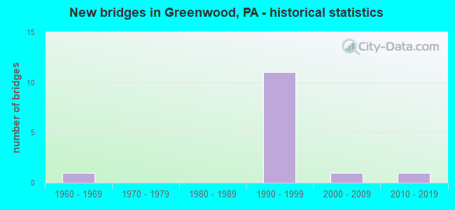
- New bridges - historical statistics
- 11960-1969
- 111990-1999
- 12000-2009
- 12010-2019


- Bridge Condition - Deck
- 40.0%Very good
- 60.0%Good

- Bridge Condition - Superstructure
- 80.0%Very good
- 20.0%Good

- Bridge Condition - Substructure
- 40.0%Very good
- 60.0%Good

- Bridge Condition - Channel
- 80.0%Satisfactory
- 20.0%Fair
Find on map >> Show street view
Structure Number: 5604, Location: 1 MI EAST OF PINECROFT (Lat: 40.561872, Lng: -78.328492), Route carried "on" structure: Interstate 99, Year Built: 1994, Status: Open, Structure Length: 3.32m (10.89ft), Average Daily Traffic: 11,461 (year 2021), Truck Traffic: 15%, Average Future Daily Traffic: 15,753 (year 2032), Design Load: HS 25 or greater, Features Intersected: PA 764/SR 1018 @ EXIT 39
Minimum Vertical Clearance: 30+ m (98+ ft), Kilometerpoint: 38.756, Lanes on structure: 2, Lanes under structure: 6, Base Highway Network: Yes, Owner: State Highway Agency, Approaching Roadway Width: 12.2m (40.0ft), Skew: 10 degrees, Material/Design: Prestressed concrete, Design/Construction: Stringer/Multi-beam, Number Of Spans In Main Unit: 1, Length of Maximum Span: 32.3m (106.0ft), Curb or Sidewalk Widths: Left: 0.2m (0.7ft), Right: 0.2m (0.7ft), Curb-To-Curb Width: 12.2m (40.0ft), Out-to-Out Width: 13.3m (43.6ft)
Condition: Deck: Good, Superstructure: Good, Substructure: Good, Operating Rating: 96.2 metric tons, Method Used To Determine Operating Rating: Load Factor (LF), Inventory Rating: 48.1 metric tons, Method Used To Determine Inventory Rating: Load Factor (LF), Structural Evaluation: Better than present minimum criteria, Deck Geometry: Better than present minimum criteria, Underclear: Equal to present desirable criteria, Approach Roadway Alignment: Equal to present desirable criteria, Length Of Structure Improvement: 4.10m (13.45ft), Designated Inspection Frequency: Every 48 months, Inspection Date: March 2021, Deck Structure Type: Concrete Cast-file-Place, Wearing Surface/Protective System: Wearing Surface: Epoxy Overlay, Deck Protection: Epoxy Coated Reinforcing
Find on map >> Show street view
Structure Number: 5653, Location: 2 MI.N.OF GREENWOOD (Lat: 40.564781, Lng: -78.338292), Route carried "on" structure: State highway 764, Year Built: 1993, Status: Open, Structure Length: 1.07m (3.51ft), Average Daily Traffic: 9,629 (year 2020), Truck Traffic: 2%, Average Future Daily Traffic: 10,507 (year 2032), Design Load: HS 20, Features Intersected: SMALL RUN
Minimum Vertical Clearance: 30+ m (98+ ft), Kilometerpoint: 16.356, Lanes on structure: 2, Base Highway Network: Yes, Owner: State Highway Agency, Approaching Roadway Width: 19.5m (64.0ft), Skew: 1 degrees, Material/Design: Prestressed concrete, Design/Construction: Box Beam or Girders - Single/Spread, Number Of Spans In Main Unit: 1, Length of Maximum Span: 10.1m (33.1ft), Curb or Sidewalk Widths: Left: 0.2m (0.7ft), Right: 0.2m (0.7ft), Curb-To-Curb Width: 19.0m (62.3ft), Out-to-Out Width: 20.1m (65.9ft)
Condition: Deck: Good, Superstructure: Very good, Substructure: Very good, Channel: Satisfactory, Operating Rating: 89.8 metric tons, Method Used To Determine Operating Rating: Load Factor (LF), Inventory Rating: 62.6 metric tons, Method Used To Determine Inventory Rating: Load Factor (LF), Structural Evaluation: Equal to present desirable criteria, Deck Geometry: Superior to present desirable criteria, Waterway Adequacy: Superior to present desirable criteria, Approach Roadway Alignment: Equal to present desirable criteria, Length Of Structure Improvement: 1.80m (5.91ft), Designated Inspection Frequency: Every 48 months, Inspection Date: April 2019, Deck Structure Type: Concrete Cast-file-Place, Wearing Surface/Protective System: Wearing Surface: Monolithic Concrete, Deck Protection: Epoxy Coated Reinforcing
Find on map >> Show street view
Structure Number: 5654, Location: 2MI N OF GREENWOOD (Lat: 40.565681, Lng: -78.336869), Route carried "on" structure: State highway 764, Year Built: 1993, Status: Open, Structure Length: 1.13m (3.71ft), Average Daily Traffic: 5,069 (year 2020), Truck Traffic: 6%, Average Future Daily Traffic: 7,342 (year 2032), Design Load: HS 25 or greater, Features Intersected: SMALL RUN
Minimum Vertical Clearance: 30+ m (98+ ft), Kilometerpoint: 17.476, Lanes on structure: 3, Base Highway Network: Yes, Owner: State Highway Agency, Approaching Roadway Width: 18.3m (60.0ft), Skew: 22 degrees, Material/Design: Prestressed concrete, Design/Construction: Box Beam or Girders - Single/Spread, Number Of Spans In Main Unit: 1, Length of Maximum Span: 10.7m (35.1ft), Curb or Sidewalk Widths: Left: 0.2m (0.7ft), Right: 0.2m (0.7ft), Curb-To-Curb Width: 18.3m (60.0ft), Out-to-Out Width: 19.4m (63.6ft)
Condition: Deck: Very good, Superstructure: Very good, Substructure: Good, Channel: Fair, Operating Rating: 68.0 metric tons, Method Used To Determine Operating Rating: Load Factor (LF), Inventory Rating: 40.8 metric tons, Method Used To Determine Inventory Rating: Load Factor (LF), Structural Evaluation: Better than present minimum criteria, Deck Geometry: Superior to present desirable criteria, Waterway Adequacy: Equal to present desirable criteria, Approach Roadway Alignment: Equal to present desirable criteria, Length Of Structure Improvement: 1.70m (5.58ft), Designated Inspection Frequency: Every 48 months, Inspection Date: April 2019, Deck Structure Type: Concrete Cast-file-Place, Wearing Surface/Protective System: Wearing Surface: Epoxy Overlay, Deck Protection: Epoxy Coated Reinforcing
Find on map >> Show street view
Structure Number: 5675, Location: .25 MI.S.OF GREENWOOD (Lat: 40.528172, Lng: -78.363744), Route carried "on" structure: US 220B, Year Built: 1961, Year Reconstructed: 2015, Status: Open, Structure Length: 0.73m (2.40ft), Average Daily Traffic: 10,495 (year 2020), Truck Traffic: 2%, Average Future Daily Traffic: 30,577 (year 2032), Design Load: HL 93, Features Intersected: KETTLE CREEK, Facility Carried by Structure: SR 1001/BUS US 220
Minimum Vertical Clearance: 30+ m (98+ ft), Kilometerpoint: 11.352, Lanes on structure: 2, Base Highway Network: Yes, Owner: State Highway Agency, Approaching Roadway Width: 22.3m (73.2ft), Skew: 3 degrees, Material/Design: Prestressed concrete, Design/Construction: Slab, Number Of Spans In Main Unit: 1, Length of Maximum Span: 6.7m (22.0ft), Curb-To-Curb Width: 22.3m (73.2ft), Out-to-Out Width: 23.4m (76.8ft)
Condition: Deck: Very good, Superstructure: Very good, Substructure: Good, Channel: Satisfactory, Operating Rating: 50.9 metric tons, Method Used To Determine Operating Rating: Assigned ratings based on Load and Resistance Factor Design (LRFD) reported by rating factor (RF) using HL93 loadings, Inventory Rating: 35.6 metric tons, Method Used To Determine Inventory Rating: Assigned ratings based on Load and Resistance Factor Design (LRFD) reported by rating factor (RF) using HL93 loadings, Structural Evaluation: Better than present minimum criteria, Deck Geometry: Superior to present desirable criteria, Waterway Adequacy: Equal to present minimum criteria, Approach Roadway Alignment: Equal to present desirable criteria, Length Of Structure Improvement: 1.30m (4.27ft), Designated Inspection Frequency: Every 48 months, Inspection Date: January 2019, Deck Structure Type: Concrete Cast-file-Place, Wearing Surface/Protective System: Wearing Surface: Monolithic Concrete, Deck Protection: Epoxy Coated Reinforcing
Find on map >> Show street view
Structure Number: 44225, Location: GREENWOOD (Lat: 40.529822, Lng: -78.365369), Route carried "on" structure: State highway 764, Year Built: 2007, Status: Open, Structure Length: 0.76m (2.49ft), Average Daily Traffic: 2,770 (year 2020), Truck Traffic: 2%, Average Future Daily Traffic: 6,274 (year 2032), Design Load: HL 93, Features Intersected: KETTLE CREEK
Minimum Vertical Clearance: 30+ m (98+ ft), Kilometerpoint: 12.080, Lanes on structure: 3, Owner: State Highway Agency, Approaching Roadway Width: 8.5m (27.9ft), Skew: 1 degrees, Material/Design: Concrete, Design/Construction: Culvert, Number Of Spans In Main Unit: 1, Length of Maximum Span: 6.7m (22.0ft), Curb-To-Curb Width: 15.5m (50.9ft), Out-to-Out Width: 16.3m (53.5ft)
Condition: Channel: Satisfactory, Culverts: Very good, Operating Rating: 62.6 metric tons, Method Used To Determine Operating Rating: Load and Resistance Factor (LRFR), Inventory Rating: 48.1 metric tons, Method Used To Determine Inventory Rating: Load and Resistance Factor (LRFR), Structural Evaluation: Equal to present desirable criteria, Deck Geometry: Equal to present minimum criteria, Waterway Adequacy: Equal to present desirable criteria, Approach Roadway Alignment: Equal to present desirable criteria, Designated Inspection Frequency: Every 48 months, Inspection Date: July 2018, Wearing Surface/Protective System: Wearing Surface: Bituminous, Membrane: Preformed Fabric, Deck Protection: Galvanized Reinforcing
Find on map >> Show street view
Structure Number: 53671, Location: 1 MI N OF GREENWOOD (Lat: 40.551467, Lng: -78.346681), Route carried "on" structure: State highway 764, Year Built: 2016, Status: Open, Structure Length: 2.44m (8.01ft), Average Daily Traffic: 9,629 (year 2020), Truck Traffic: 2%, Average Future Daily Traffic: 12,829 (year 2036), Design Load: HL 93, Features Intersected: SANDY RUN
Minimum Vertical Clearance: 30+ m (98+ ft), Kilometerpoint: 15.274, Lanes on structure: 3, Base Highway Network: Yes, Owner: State Highway Agency, Approaching Roadway Width: 17.4m (57.1ft), Skew: 4 degrees, Material/Design: Prestressed concrete, Design/Construction: Box Beam or Girders - Single/Spread, Number Of Spans In Main Unit: 1, Length of Maximum Span: 23.2m (76.1ft), Curb or Sidewalk Widths: Left: 0.2m (0.7ft), Right: 0.2m (0.7ft), Curb-To-Curb Width: 17.2m (56.4ft), Out-to-Out Width: 18.3m (60.0ft)
Condition: Deck: Good, Superstructure: Very good, Substructure: Very good, Channel: Satisfactory, Operating Rating: 49.2 metric tons, Method Used To Determine Operating Rating: Assigned ratings based on Load and Resistance Factor Design (LRFD) reported by rating factor (RF) using HL93 loadings, Inventory Rating: 38.2 metric tons, Method Used To Determine Inventory Rating: Assigned ratings based on Load and Resistance Factor Design (LRFD) reported by rating factor (RF) using HL93 loadings, Structural Evaluation: Equal to present desirable criteria, Deck Geometry: Superior to present desirable criteria, Waterway Adequacy: Superior to present desirable criteria, Approach Roadway Alignment: Equal to present desirable criteria, Designated Inspection Frequency: Every 24 months, Inspection Date: September 2020, Deck Structure Type: Concrete Cast-file-Place, Wearing Surface/Protective System: Wearing Surface: Monolithic Concrete, Deck Protection: Epoxy Coated Reinforcing
Find on map >> Show street view
Structure Number: 5603, Location: VILLAGE OF BELLMEADE (Lat: 40.539250, Lng: -78.346831), Route carried "under" structure: Interstate 99, Year Built: 1992, Structure Length: 0. m, Average Daily Traffic: 12,352 (year 2021), Truck Traffic: 16%, Features Intersected: I-99 / US 220, Facility Carried by Structure: T401 CARLISLE LANE
Minimum Vertical Clearance: 6.00m (19.69ft), Kilometerpoint: 35.558, Lanes on structure: 2, Lanes under structure: 2, Material/Design: Prestressed concrete, Design/Construction: Stringer/Multi-beam, Length of Maximum Span: 25.6m (84.0ft)
Find on map >> Show street view
Structure Number: 5603, Location: VILLAGE OF BELLMEADE (Lat: 40.539250, Lng: -78.346831), Route carried "under" structure: Interstate 99, Year Built: 1992, Structure Length: 0. m, Average Daily Traffic: 12,214 (year 2021), Truck Traffic: 15%, Features Intersected: I-99 / US 220, Facility Carried by Structure: T401 CARLISLE LANE
Minimum Vertical Clearance: 5.74m (18.83ft), Kilometerpoint: 35.563, Lanes on structure: 2, Lanes under structure: 2, Material/Design: Prestressed concrete, Design/Construction: Stringer/Multi-beam, Length of Maximum Span: 25.6m (84.0ft)
Find on map >> Show street view
Structure Number: 5604, Location: 1 MI EAST OF PINECROFT (Lat: 40.561872, Lng: -78.328492), Route carried "under" structure: State highway 764, Year Built: 1994, Structure Length: 0. m, Average Daily Traffic: 2,510 (year 2020), Truck Traffic: 6%, Features Intersected: PA 764/SR 1018 @ EXIT 39, Facility Carried by Structure: I-99 / US 220 NBL
Minimum Vertical Clearance: 5.31m (17.42ft), Kilometerpoint: 17.476, Lanes on structure: 2, Lanes under structure: 2, Material/Design: Prestressed concrete, Design/Construction: Stringer/Multi-beam, Length of Maximum Span: 32.3m (106.0ft)
Find on map >> Show street view
Structure Number: 5604, Location: 1 MI EAST OF PINECROFT (Lat: 40.561872, Lng: -78.328492), Route carried "under" structure: State highway , Year Built: 1994, Structure Length: 0. m, Average Daily Traffic: 1,648 (year 2021), Truck Traffic: 9%, Features Intersected: PA 764/SR 1018 @ EXIT 39, Facility Carried by Structure: I-99 / US 220 NBL
Minimum Vertical Clearance: 5.31m (17.42ft), Kilometerpoint: 0.000, Lanes on structure: 2, Lanes under structure: 2, Material/Design: Prestressed concrete, Design/Construction: Stringer/Multi-beam, Length of Maximum Span: 32.3m (106.0ft)
Find on map >> Show street view
Structure Number: 5604, Location: 1 MI EAST OF PINECROFT (Lat: 40.561872, Lng: -78.328492), Route carried "under" structure: State highway , Year Built: 1994, Structure Length: 0. m, Average Daily Traffic: 1,990 (year 2021), Truck Traffic: 8%, Features Intersected: PA 764/SR 1018 @ EXIT 39, Facility Carried by Structure: I-99 / US 220 NBL
Minimum Vertical Clearance: 5.28m (17.32ft), Kilometerpoint: 0.000, Lanes on structure: 2, Lanes under structure: 1, Material/Design: Prestressed concrete, Design/Construction: Stringer/Multi-beam, Length of Maximum Span: 32.3m (106.0ft)
Find on map >> Show street view
Structure Number: 5604, Location: 1 MI EAST OF PINECROFT (Lat: 40.561872, Lng: -78.328492), Route carried "under" structure: State highway 764, Year Built: 1994, Structure Length: 0. m, Average Daily Traffic: 2,559 (year 2020), Truck Traffic: 6%, Features Intersected: PA 764/SR 1018 @ EXIT 39, Facility Carried by Structure: I-99 / US 220 NBL
Minimum Vertical Clearance: 5.28m (17.32ft), Kilometerpoint: 17.476, Lanes on structure: 2, Lanes under structure: 1, Material/Design: Prestressed concrete, Design/Construction: Stringer/Multi-beam, Length of Maximum Span: 32.3m (106.0ft)
Find on map >> Show street view
Structure Number: 5606, Location: 1 MI EAST OF PINECROFT (Lat: 40.562417, Lng: -78.328403), Route carried "under" structure: State highway 764, Year Built: 1994, Structure Length: 0. m, Average Daily Traffic: 2,510 (year 2020), Truck Traffic: 6%, Features Intersected: PA 764 @ EXIT 39, Facility Carried by Structure: I-99 / US 220 SBL
Minimum Vertical Clearance: 6.00m (19.69ft), Kilometerpoint: 17.476, Lanes on structure: 2, Lanes under structure: 1, Material/Design: Prestressed concrete, Design/Construction: Stringer/Multi-beam, Length of Maximum Span: 32.3m (106.0ft)
Find on map >> Show street view
Structure Number: 5606, Location: 1 MI EAST OF PINECROFT (Lat: 40.562417, Lng: -78.328403), Route carried "under" structure: State highway 764, Year Built: 1994, Structure Length: 0. m, Average Daily Traffic: 2,559 (year 2020), Truck Traffic: 6%, Features Intersected: PA 764 @ EXIT 39, Facility Carried by Structure: I-99 / US 220 SBL
Minimum Vertical Clearance: 5.97m (19.59ft), Kilometerpoint: 17.476, Lanes on structure: 2, Lanes under structure: 2, Material/Design: Prestressed concrete, Design/Construction: Stringer/Multi-beam, Length of Maximum Span: 32.3m (106.0ft)