Bridge Statistics for Greenwood, Nebraska (NE)
Condition, Traffic, Stress, Structural Evaluation, Project Costs
- National Bridge Inventory (NBI) Statistics
- 33Number of bridges
- 289ft / 87.7mTotal length
- 388,620Total average daily traffic
- 62,074Total average daily truck traffic
- National Bridge Inventory (NBI) Registered Bridges for Greenwood
- No street view available for this location
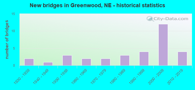
- New bridges - historical statistics
- 21930-1939
- 11940-1949
- 31950-1959
- 21960-1969
- 21970-1979
- 31980-1989
- 41990-1999
- 122000-2009
- 42010-2019

- Reconstructed bridges - Historical Statistics
- 11970-1979
- 01980-1989
- 21990-1999
- 12000-2009


- Bridge Condition - Deck
- 4.2%Excellent
- 20.8%Very good
- 50.0%Good
- 16.7%Satisfactory
- 8.3%Fair

- Bridge Condition - Superstructure
- 12.5%Excellent
- 33.3%Very good
- 41.7%Good
- 4.2%Satisfactory
- 8.3%Serious

- Bridge Condition - Substructure
- 12.5%Excellent
- 20.8%Very good
- 33.3%Good
- 16.7%Satisfactory
- 12.5%Fair
- 4.2%Poor

- Bridge Condition - Channel
- 3.7%Excellent
- 25.9%Very good
- 7.4%Good
- 29.6%Satisfactory
- 22.2%Fair
- 11.1%Poor

- Bridge Condition - Culverts
- 33.3%Very good
- 16.7%Good
- 16.7%Satisfactory
- 16.7%Fair
- 16.7%Poor
Find on map >> Show street view
Structure Number: C00130032, Location: 2.2S OF GREENWOOD (Lat: 40.926200, Lng: -96.446000), Route carried "on" structure: County highway 3, Year Built: 1953, Status: Open, Structure Length: 1.68m (5.51ft), Average Daily Traffic: 35 (year 2003), Average Future Daily Traffic: 59 (year 2033), Features Intersected: DEE CREEK, Facility Carried by Structure: 202ND ST
Minimum Vertical Clearance: 30+ m (98+ ft), Kilometerpoint: 0.000, Lanes on structure: 2, Owner: County Highway Agency, Approaching Roadway Width: 7.0m (23.0ft), Material/Design: Steel, Design/Construction: Stringer/Multi-beam, Number Of Spans In Main Unit: 1, Length of Maximum Span: 16.2m (53.1ft), Curb-To-Curb Width: 8.6m (28.2ft), Out-to-Out Width: 8.7m (28.5ft)
Condition: Deck: Satisfactory, Superstructure: Good, Substructure: Satisfactory, Channel: Satisfactory, Operating Rating: 62.0 metric tons, Method Used To Determine Operating Rating: Load Factor (LF), Inventory Rating: 36.0 metric tons, Method Used To Determine Inventory Rating: Load Factor (LF), Structural Evaluation: Equal to present minimum criteria, Deck Geometry: Better than present minimum criteria, Waterway Adequacy: Equal to present minimum criteria, Approach Roadway Alignment: Equal to present desirable criteria, Designated Inspection Frequency: Every 24 months, Inspection Date: November 2021, Deck Structure Type: Concrete Cast-file-Place, Wearing Surface/Protective System: Wearing Surface: Monolithic Concrete
Find on map >> Show street view
Structure Number: C00130051, Location: .5E 3.1S OF GREENWOOD (Lat: 40.913100, Lng: -96.427500), Route carried "on" structure: County highway 5, Year Built: 1992, Status: Open, Structure Length: 1.83m (6.00ft), Average Daily Traffic: 50 (year 2003), Average Future Daily Traffic: 85 (year 2033), Features Intersected: DEE CREEK, Facility Carried by Structure: BLUFF RD
Minimum Vertical Clearance: 30+ m (98+ ft), Kilometerpoint: 0.000, Lanes on structure: 2, Owner: County Highway Agency, Approaching Roadway Width: 7.9m (25.9ft), Skew: 3 degrees, Material/Design: Steel, Design/Construction: Stringer/Multi-beam, Number Of Spans In Main Unit: 1, Length of Maximum Span: 18.0m (59.1ft), Curb-To-Curb Width: 8.5m (27.9ft), Out-to-Out Width: 8.6m (28.2ft)
Condition: Deck: Good, Superstructure: Very good, Substructure: Good, Channel: Fair, Operating Rating: 36.0 metric tons, Method Used To Determine Operating Rating: Load Factor (LF), Inventory Rating: 22.0 metric tons, Method Used To Determine Inventory Rating: Load Factor (LF), Structural Evaluation: Equal to present minimum criteria, Deck Geometry: Better than present minimum criteria, Waterway Adequacy: Better than present minimum criteria, Approach Roadway Alignment: Equal to present desirable criteria, Designated Inspection Frequency: Every 24 months, Inspection Date: November 2021, Deck Structure Type: Concrete Cast-file-Place, Wearing Surface/Protective System: Wearing Surface: Monolithic Concrete
Find on map >> Show street view
Structure Number: C001301405, Location: .5N 1.4E OF GREENWOOD (Lat: 40.972000, Lng: -96.411000), Route carried "on" structure: County highway 14, Year Built: 2015, Status: Open, Structure Length: 2.50m (8.20ft), Average Daily Traffic: 150 (year 2015), Truck Traffic: 15%, Average Future Daily Traffic: 205 (year 2035), Features Intersected: GREENWOOD CREEK, Facility Carried by Structure: MYNARD RD
Minimum Vertical Clearance: 30+ m (98+ ft), Kilometerpoint: 0.000, Lanes on structure: 2, Owner: County Highway Agency, Approaching Roadway Width: 8.5m (27.9ft), Material/Design: Concrete, Design/Construction: Slab, Number Of Spans In Main Unit: 3, Length of Maximum Span: 9.8m (32.2ft), Curb-To-Curb Width: 8.5m (27.9ft), Out-to-Out Width: 9.3m (30.5ft)
Condition: Deck: Very good, Superstructure: Excellent, Substructure: Excellent, Channel: Very good, Operating Rating: 48.0 metric tons, Method Used To Determine Operating Rating: Load and Resistance Factor (LRFR), Inventory Rating: 37.0 metric tons, Method Used To Determine Inventory Rating: Load and Resistance Factor (LRFR), Structural Evaluation: Superior to present desirable criteria, Deck Geometry: Equal to present minimum criteria, Waterway Adequacy: Meets minimum limits, Approach Roadway Alignment: Equal to present desirable criteria, Length Of Structure Improvement: 1.28m (4.20ft), Designated Inspection Frequency: Every 24 months, Inspection Date: November 2021, Deck Structure Type: Concrete Cast-file-Place, Wearing Surface/Protective System: Wearing Surface: Monolithic Concrete
Find on map >> Show street view
Structure Number: C001301405P, Location: .2W OF GREENWOOD (Lat: 40.965300, Lng: -96.454900), Route carried "on" structure: County highway 7834, Year Built: 1948, Status: Posted for load, Structure Length: 7.80m (25.59ft), Average Daily Traffic: 240 (year 1998), Average Future Daily Traffic: 408 (year 2033), Features Intersected: SALT CREEK, Facility Carried by Structure: GREENWOOD DR
Minimum Vertical Clearance: 30+ m (98+ ft), Kilometerpoint: 1.186, Lanes on structure: 2, Owner: County Highway Agency, Approaching Roadway Width: 7.9m (25.9ft), Material/Design: Steel continuous, Design/Construction: Stringer/Multi-beam, Number Of Spans In Main Unit: 3, Length of Maximum Span: 29.9m (98.1ft), Curb or Sidewalk Widths: Left: 0.3m (1.0ft), Right: 0.3m (1.0ft), Curb-To-Curb Width: 6.7m (22.0ft), Out-to-Out Width: 7.4m (24.3ft)
Condition: Deck: Satisfactory, Superstructure: Satisfactory, Substructure: Fair, Channel: Satisfactory, Operating Rating: 34.0 metric tons, Method Used To Determine Operating Rating: Load Factor (LF), Inventory Rating: 20.0 metric tons, Method Used To Determine Inventory Rating: Load Factor (LF), Structural Evaluation: Somewhat better than minimum adequacy, Deck Geometry: Meets minimum limits, Waterway Adequacy: Equal to present desirable criteria, Approach Roadway Alignment: Equal to present desirable criteria, Bridge Posting: Required (Relationship of Operating Rating to Maximum Legal Load: 0.1 - 9.9% below), Designated Inspection Frequency: Every 24 months, Inspection Date: November 2021, Deck Structure Type: Concrete Cast-file-Place, Wearing Surface/Protective System: Wearing Surface: Monolithic Concrete
Find on map >> Show street view
Structure Number: C001301407, Location: .5N 1.6E GREENWOOD (Lat: 40.972000, Lng: -96.410300), Route carried "on" structure: County highway 14, Year Built: 2015, Status: Open, Structure Length: 0.63m (2.07ft), Average Daily Traffic: 150 (year 2015), Truck Traffic: 15%, Average Future Daily Traffic: 205 (year 2035), Design Load: HL 93, Features Intersected: GREENWOOD CREEK TRIB, Facility Carried by Structure: MYNARD RD
Minimum Vertical Clearance: 30+ m (98+ ft), Kilometerpoint: 0.000, Lanes on structure: 2, Owner: County Highway Agency, Approaching Roadway Width: 8.5m (27.9ft), Material/Design: Concrete, Design/Construction: Culvert, Number Of Spans In Main Unit: 2, Length of Maximum Span: 3.0m (9.8ft)
Condition: Channel: Very good, Culverts: Very good, Operating Rating: 42.0 metric tons, Method Used To Determine Operating Rating: Field evaluation and documented engineering judgment, Inventory Rating: 33.0 metric tons, Method Used To Determine Inventory Rating: Field evaluation and documented engineering judgment, Structural Evaluation: Equal to present desirable criteria, Waterway Adequacy: Superior to present desirable criteria, Approach Roadway Alignment: Superior to present desirable criteria, Designated Inspection Frequency: Every 24 months, Inspection Date: November 2021
Find on map >> Show street view
Structure Number: C001301605, Location: JCT I80/N63 1S 1.9W (Lat: 40.957700, Lng: -96.425400), Route carried "on" structure: County highway 3730, Year Built: 2001, Status: Open, Structure Length: 2.19m (7.19ft), Average Daily Traffic: 200 (year 2011), Average Future Daily Traffic: 200 (year 2033), Features Intersected: GREENWOOD CREEK, Facility Carried by Structure: CHURCH RD
Minimum Vertical Clearance: 30+ m (98+ ft), Kilometerpoint: 0.174, Lanes on structure: 2, Owner: County Highway Agency, Approaching Roadway Width: 7.3m (24.0ft), Skew: 2 degrees, Material/Design: Concrete continuous, Design/Construction: Slab, Number Of Spans In Main Unit: 3, Length of Maximum Span: 8.5m (27.9ft), Curb-To-Curb Width: 9.1m (29.9ft), Out-to-Out Width: 9.8m (32.2ft)
Condition: Deck: Good, Superstructure: Good, Substructure: Good, Channel: Good, Operating Rating: 55.0 metric tons, Method Used To Determine Operating Rating: Load Factor (LF), Inventory Rating: 33.0 metric tons, Method Used To Determine Inventory Rating: Load Factor (LF), Structural Evaluation: Better than present minimum criteria, Deck Geometry: Equal to present minimum criteria, Waterway Adequacy: Equal to present desirable criteria, Approach Roadway Alignment: Equal to present desirable criteria, Length Of Structure Improvement: 0.98m (3.22ft), Designated Inspection Frequency: Every 24 months, Inspection Date: November 2021, Deck Structure Type: Concrete Cast-file-Place, Wearing Surface/Protective System: Wearing Surface: Monolithic Concrete, Deck Protection: Epoxy Coated Reinforcing
Find on map >> Show street view
Structure Number: C001301805, Location: 1S .5W OF GREENWOOD (Lat: 40.943000, Lng: -96.455000), Route carried "on" structure: County highway 18, Year Built: 1983, Year Reconstructed: 2004, Status: Posted for load, Structure Length: 1.22m (4.00ft), Average Daily Traffic: 15 (year 2003), Average Future Daily Traffic: 25 (year 2033), Features Intersected: DEE CREEK, Facility Carried by Structure: MILL RD
Minimum Vertical Clearance: 30+ m (98+ ft), Kilometerpoint: 0.000, Lanes on structure: 2, Owner: County Highway Agency, Approaching Roadway Width: 6.7m (22.0ft), Material/Design: Steel, Design/Construction: Stringer/Multi-beam, Number Of Spans In Main Unit: 1, Length of Maximum Span: 11.6m (38.1ft), Curb-To-Curb Width: 7.9m (25.9ft), Out-to-Out Width: 8.1m (26.6ft)
Condition: Deck: Satisfactory, Superstructure: Good, Substructure: Satisfactory, Channel: Fair, Operating Rating: 33.0 metric tons, Method Used To Determine Operating Rating: Load Factor (LF), Inventory Rating: 20.0 metric tons, Method Used To Determine Inventory Rating: Load Factor (LF), Structural Evaluation: Somewhat better than minimum adequacy, Deck Geometry: Equal to present minimum criteria, Waterway Adequacy: Meets minimum limits, Approach Roadway Alignment: Equal to present desirable criteria, Bridge Posting: Required (Relationship of Operating Rating to Maximum Legal Load: 10.0 - 19.9% below), Length Of Structure Improvement: 1.22m (4.00ft), Designated Inspection Frequency: Every 24 months, Inspection Date: November 2021, Deck Structure Type: Concrete Cast-file-Place, Wearing Surface/Protective System: Wearing Surface: Monolithic Concrete
Find on map >> Show street view
Structure Number: C00130181, Location: 1S .7E OF GREENWOOD (Lat: 40.943300, Lng: -96.419700), Route carried "on" structure: County highway 18, Year Built: 2013, Status: Open, Structure Length: 1.55m (5.09ft), Average Daily Traffic: 60 (year 2003), Average Future Daily Traffic: 102 (year 2033), Features Intersected: GREENWOOD CREEK, Facility Carried by Structure: MILL RD
Minimum Vertical Clearance: 30+ m (98+ ft), Kilometerpoint: 0.000, Lanes on structure: 2, Owner: County Highway Agency, Approaching Roadway Width: 7.9m (25.9ft), Material/Design: Concrete, Design/Construction: Slab, Number Of Spans In Main Unit: 2, Length of Maximum Span: 9.1m (29.9ft), Curb-To-Curb Width: 8.5m (27.9ft), Out-to-Out Width: 8.7m (28.5ft)
Condition: Deck: Excellent, Superstructure: Excellent, Substructure: Excellent, Channel: Very good, Operating Rating: 44.0 metric tons, Method Used To Determine Operating Rating: Load and Resistance Factor (LRFR), Inventory Rating: 34.0 metric tons, Method Used To Determine Inventory Rating: Load and Resistance Factor (LRFR), Structural Evaluation: Superior to present desirable criteria, Deck Geometry: Better than present minimum criteria, Waterway Adequacy: Equal to present minimum criteria, Approach Roadway Alignment: Equal to present desirable criteria, Length Of Structure Improvement: 1.07m (3.51ft), Designated Inspection Frequency: Every 24 months, Inspection Date: November 2021, Deck Structure Type: Concrete Cast-file-Place, Wearing Surface/Protective System: Wearing Surface: Monolithic Concrete
Find on map >> Show street view
Structure Number: C001302205, Location: JCT I80/N63 4S 2.8W (Lat: 40.914500, Lng: -96.442400), Route carried "on" structure: County highway 3358, Year Built: 1952, Status: Open, Structure Length: 0.64m (2.10ft), Average Daily Traffic: 100 (year 2011), Average Future Daily Traffic: 100 (year 2033), Features Intersected: STREAM
Minimum Vertical Clearance: 30+ m (98+ ft), Kilometerpoint: 0.737, Lanes on structure: 2, Owner: County Highway Agency, Approaching Roadway Width: 7.3m (24.0ft), Material/Design: Concrete, Design/Construction: Culvert, Number Of Spans In Main Unit: 2, Length of Maximum Span: 3.0m (9.8ft)
Condition: Channel: Poor, Culverts: Satisfactory, Operating Rating: 33.0 metric tons, Method Used To Determine Operating Rating: Field evaluation and documented engineering judgment, Inventory Rating: 22.0 metric tons, Method Used To Determine Inventory Rating: Field evaluation and documented engineering judgment, Structural Evaluation: Equal to present minimum criteria, Waterway Adequacy: Meets minimum limits, Approach Roadway Alignment: Equal to present desirable criteria, Designated Inspection Frequency: Every 24 months, Inspection Date: November 2021
Find on map >> Show street view
Structure Number: C00130221, Location: JCT I80/N63 4S 2.1W (Lat: 40.914500, Lng: -96.428300), Route carried "on" structure: County highway 3358, Year Built: 2007, Status: Open, Structure Length: 3.35m (10.99ft), Average Daily Traffic: 100 (year 2011), Average Future Daily Traffic: 70 (year 2033), Features Intersected: DEE CREEK
Minimum Vertical Clearance: 30+ m (98+ ft), Kilometerpoint: 0.856, Lanes on structure: 2, Owner: County Highway Agency, Approaching Roadway Width: 8.5m (27.9ft), Skew: 3 degrees, Material/Design: Concrete continuous, Design/Construction: Slab, Number Of Spans In Main Unit: 3, Length of Maximum Span: 13.4m (44.0ft), Curb-To-Curb Width: 8.5m (27.9ft), Out-to-Out Width: 9.3m (30.5ft)
Condition: Deck: Good, Superstructure: Good, Substructure: Very good, Channel: Good, Operating Rating: 61.0 metric tons, Method Used To Determine Operating Rating: Load Factor (LF), Inventory Rating: 36.0 metric tons, Method Used To Determine Inventory Rating: Load Factor (LF), Structural Evaluation: Better than present minimum criteria, Deck Geometry: Better than present minimum criteria, Waterway Adequacy: Equal to present desirable criteria, Approach Roadway Alignment: Equal to present desirable criteria, Length Of Structure Improvement: 2.71m (8.89ft), Designated Inspection Frequency: Every 24 months, Inspection Date: September 2020, Deck Structure Type: Concrete Cast-file-Place, Wearing Surface/Protective System: Wearing Surface: Monolithic Concrete
Find on map >> Show street view
Structure Number: C00131032, Location: 2N OF GREENWOOD (Lat: 40.998300, Lng: -96.445000), Route carried "on" structure: County highway 103, Year Built: 1995, Status: Open, Structure Length: 0.61m (2.00ft), Average Daily Traffic: 55 (year 2003), Average Future Daily Traffic: 93 (year 2033), Features Intersected: STREAM, Facility Carried by Structure: COUNTY HIGHWAY
Minimum Vertical Clearance: 30+ m (98+ ft), Kilometerpoint: 0.000, Lanes on structure: 2, Owner: County Highway Agency, Approaching Roadway Width: 8.5m (27.9ft), Material/Design: Steel, Design/Construction: Culvert, Number Of Spans In Main Unit: 1, Length of Maximum Span: 6.1m (20.0ft)
Condition: Channel: Poor, Culverts: Poor, Operating Rating: 38.0 metric tons, Method Used To Determine Operating Rating: Field evaluation and documented engineering judgment, Inventory Rating: 33.0 metric tons, Method Used To Determine Inventory Rating: Field evaluation and documented engineering judgment, Structural Evaluation: Meets minimum limits, Waterway Adequacy: Meets minimum limits, Approach Roadway Alignment: Equal to present desirable criteria, Designated Inspection Frequency: Every 24 months, Inspection Date: November 2021
Find on map >> Show street view
Structure Number: C001310325, Location: 2.7N OF GREENWOOD (Lat: 41.001700, Lng: -96.445000), Route carried "on" structure: County highway 103, Year Built: 1983, Status: Posted for load, Structure Length: 1.83m (6.00ft), Average Daily Traffic: 55 (year 2003), Average Future Daily Traffic: 93 (year 2033), Features Intersected: ROBINSON BRANCH, Facility Carried by Structure: COUNTY HIGHWAY
Minimum Vertical Clearance: 30+ m (98+ ft), Kilometerpoint: 0.000, Lanes on structure: 2, Owner: County Highway Agency, Approaching Roadway Width: 8.5m (27.9ft), Material/Design: Steel, Design/Construction: Stringer/Multi-beam, Number Of Spans In Main Unit: 1, Length of Maximum Span: 17.7m (58.1ft), Curb-To-Curb Width: 8.9m (29.2ft), Out-to-Out Width: 9.1m (29.9ft)
Condition: Deck: Good, Superstructure: Very good, Substructure: Good, Channel: Satisfactory, Operating Rating: 34.0 metric tons, Method Used To Determine Operating Rating: Load Factor (LF), Inventory Rating: 20.0 metric tons, Method Used To Determine Inventory Rating: Load Factor (LF), Structural Evaluation: Somewhat better than minimum adequacy, Deck Geometry: Better than present minimum criteria, Waterway Adequacy: Equal to present minimum criteria, Approach Roadway Alignment: Equal to present desirable criteria, Bridge Posting: Required (Relationship of Operating Rating to Maximum Legal Load: 0.1 - 9.9% below), Designated Inspection Frequency: Every 24 months, Inspection Date: November 2021, Deck Structure Type: Concrete Cast-file-Place, Wearing Surface/Protective System: Wearing Surface: Monolithic Concrete
Find on map >> Show street view
Structure Number: C00131071, Location: 1.5S 2E GREENWOOD (Lat: 40.956100, Lng: -96.406700), Route carried "on" structure: County highway 107, Year Built: 1960, Year Reconstructed: 2002, Status: Open, Structure Length: 1.01m (3.31ft), Average Daily Traffic: 25 (year 1997), Average Future Daily Traffic: 42 (year 2033), Features Intersected: GREENWOOD CREEK, Facility Carried by Structure: COUNTY HIGHWAY
Minimum Vertical Clearance: 30+ m (98+ ft), Kilometerpoint: 0.000, Lanes on structure: 2, Owner: County Highway Agency, Approaching Roadway Width: 6.1m (20.0ft), Material/Design: Concrete, Design/Construction: Slab, Number Of Spans In Main Unit: 1, Length of Maximum Span: 9.4m (30.8ft), Curb-To-Curb Width: 6.0m (19.7ft), Out-to-Out Width: 6.0m (19.7ft)
Condition: Deck: Very good, Superstructure: Very good, Substructure: Fair, Channel: Poor, Operating Rating: 74.0 metric tons, Method Used To Determine Operating Rating: Load Factor (LF), Inventory Rating: 44.0 metric tons, Method Used To Determine Inventory Rating: Load Factor (LF), Structural Evaluation: Somewhat better than minimum adequacy, Deck Geometry: Meets minimum limits, Waterway Adequacy: Meets minimum limits, Approach Roadway Alignment: Equal to present desirable criteria, Designated Inspection Frequency: Every 24 months, Inspection Date: November 2021, Deck Structure Type: Concrete Cast-file-Place, Wearing Surface/Protective System: Wearing Surface: Monolithic Concrete
Find on map >> Show street view
Structure Number: C001310715, Location: 1.5E 1.4N OF GREENWOOD (Lat: 40.978200, Lng: -96.407100), Route carried "on" structure: County highway 107, Year Built: 1935, Status: Posted for load, Structure Length: 1.43m (4.69ft), Average Daily Traffic: 25 (year 2003), Average Future Daily Traffic: 42 (year 2033), Features Intersected: GREENWOOD CREEK, Facility Carried by Structure: 226TH ST
Minimum Vertical Clearance: 30+ m (98+ ft), Kilometerpoint: 0.000, Lanes on structure: 1, Owner: County Highway Agency, Approaching Roadway Width: 6.1m (20.0ft), Material/Design: Steel, Design/Construction: Stringer/Multi-beam, Number Of Spans In Main Unit: 2, Length of Maximum Span: 10.1m (33.1ft), Curb-To-Curb Width: 4.8m (15.7ft), Out-to-Out Width: 4.9m (16.1ft)
Condition: Deck: Fair, Superstructure: Serious, Substructure: Fair, Channel: Satisfactory, Operating Rating: 7.0 metric tons, Method Used To Determine Operating Rating: Load Factor (LF), Inventory Rating: 5.0 metric tons, Method Used To Determine Inventory Rating: Load Factor (LF), Structural Evaluation: High priority of replacement, Deck Geometry: Equal to present desirable criteria, Waterway Adequacy: Meets minimum limits, Approach Roadway Alignment: Equal to present minimum criteria, Bridge Posting: Required (Relationship of Operating Rating to Maximum Legal Load: > 39.9% below), Length Of Structure Improvement: 1.43m (4.69ft), Designated Inspection Frequency: Every 24 months, Other Special Inspection Frequency: Every 24 months, Inspection Date: November 2021, Other Special Inspection Date: September 2020, Deck Structure Type: Corrugated Steel, Wearing Surface/Protective System: Wearing Surface: Gravel
Find on map >> Show street view
Structure Number: C00131072, Location: 1.5E 1.5N OF GREENWOOD (Lat: 40.979400, Lng: -96.407000), Route carried "on" structure: County highway 107, Year Built: 1935, Status: Posted for load, Structure Length: 1.49m (4.89ft), Average Daily Traffic: 25 (year 2003), Average Future Daily Traffic: 42 (year 2033), Features Intersected: GREENWOOD CREEK, Facility Carried by Structure: COUNTY HIGHWAY
Minimum Vertical Clearance: 30+ m (98+ ft), Kilometerpoint: 0.000, Lanes on structure: 1, Owner: County Highway Agency, Approaching Roadway Width: 6.1m (20.0ft), Material/Design: Steel, Design/Construction: Stringer/Multi-beam, Number Of Spans In Main Unit: 2, Length of Maximum Span: 10.1m (33.1ft), Curb-To-Curb Width: 4.8m (15.7ft), Out-to-Out Width: 4.9m (16.1ft)
Condition: Deck: Fair, Superstructure: Serious, Substructure: Poor, Channel: Satisfactory, Operating Rating: 5.0 metric tons, Method Used To Determine Operating Rating: Load Factor (LF), Inventory Rating: 3.0 metric tons, Method Used To Determine Inventory Rating: Load Factor (LF), Structural Evaluation: High priority of replacement, Deck Geometry: Equal to present desirable criteria, Waterway Adequacy: Equal to present minimum criteria, Approach Roadway Alignment: Somewhat better than minimum adequacy, Bridge Posting: Required (Relationship of Operating Rating to Maximum Legal Load: > 39.9% below), Length Of Structure Improvement: 1.49m (4.89ft), Designated Inspection Frequency: Every 24 months, Other Special Inspection Frequency: Every 24 months, Inspection Date: November 2021, Other Special Inspection Date: September 2020, Deck Structure Type: Corrugated Steel, Wearing Surface/Protective System: Wearing Surface: Gravel
Find on map >> Show street view
Structure Number: C00550066, Location: 3E 6.5N OF WAVERLY (Lat: 41.016000, Lng: -96.467200), Route carried "on" structure: County highway 7836, Year Built: 1978, Status: Open, Structure Length: 2.19m (7.19ft), Average Daily Traffic: 11 (year 2012), Average Future Daily Traffic: 18 (year 2042), Design Load: H 20, Features Intersected: ROBINSON BRANCH (A 128), Facility Carried by Structure: AGNEW RD.
Minimum Vertical Clearance: 30+ m (98+ ft), Kilometerpoint: 0.293, Lanes on structure: 2, Owner: County Highway Agency, Approaching Roadway Width: 7.9m (25.9ft), Material/Design: Steel, Design/Construction: Stringer/Multi-beam, Number Of Spans In Main Unit: 1, Length of Maximum Span: 21.3m (69.9ft), Curb-To-Curb Width: 8.5m (27.9ft), Out-to-Out Width: 8.7m (28.5ft)
Condition: Deck: Good, Superstructure: Good, Substructure: Good, Channel: Fair, Operating Rating: 46.0 metric tons, Method Used To Determine Operating Rating: Load Factor (LF), Inventory Rating: 27.0 metric tons, Method Used To Determine Inventory Rating: Load Factor (LF), Structural Evaluation: Equal to present minimum criteria, Deck Geometry: Better than present minimum criteria, Waterway Adequacy: Equal to present desirable criteria, Approach Roadway Alignment: Equal to present desirable criteria, Designated Inspection Frequency: Every 24 months, Inspection Date: March 2022, Deck Structure Type: Concrete Cast-file-Place, Wearing Surface/Protective System: Wearing Surface: Monolithic Concrete
Find on map >> Show street view
Structure Number: C00551183, Location: 2.2E 1N OF WAVERLY (Lat: 40.928900, Lng: -96.477000), Route carried "on" structure: County highway 118, Year Built: 1993, Status: Open, Structure Length: 3.57m (11.71ft), Average Daily Traffic: 42 (year 2015), Average Future Daily Traffic: 71 (year 2037), Design Load: HS 20, Features Intersected: CAMP CREEK (H 98), Facility Carried by Structure: WAVERLY RD
Minimum Vertical Clearance: 30+ m (98+ ft), Kilometerpoint: 0.000, Lanes on structure: 2, Owner: County Highway Agency, Approaching Roadway Width: 8.5m (27.9ft), Material/Design: Concrete continuous, Design/Construction: Slab, Number Of Spans In Main Unit: 3, Length of Maximum Span: 14.0m (45.9ft), Curb-To-Curb Width: 8.5m (27.9ft), Out-to-Out Width: 9.2m (30.2ft)
Condition: Deck: Good, Superstructure: Good, Substructure: Good, Channel: Fair, Operating Rating: 62.0 metric tons, Method Used To Determine Operating Rating: Load Factor (LF), Inventory Rating: 36.0 metric tons, Method Used To Determine Inventory Rating: Load Factor (LF), Structural Evaluation: Better than present minimum criteria, Deck Geometry: Better than present minimum criteria, Waterway Adequacy: Better than present minimum criteria, Approach Roadway Alignment: Equal to present desirable criteria, Designated Inspection Frequency: Every 24 months, Inspection Date: Febuary 2021, Deck Structure Type: Concrete Cast-file-Place, Wearing Surface/Protective System: Wearing Surface: Monolithic Concrete
Find on map >> Show street view
Structure Number: C005544933, Location: 4N US6 CASS CL (Lat: 40.997000, Lng: -96.463900), Route carried "on" structure: County highway 649, Year Built: 1984, Status: Open, Structure Length: 0.70m (2.30ft), Average Daily Traffic: 100 (year 2003), Truck Traffic: 10%, Average Future Daily Traffic: 170 (year 2033), Features Intersected: STREAM (A 29), Facility Carried by Structure: COUNTY HIGHWAY
Minimum Vertical Clearance: 30+ m (98+ ft), Kilometerpoint: 0.000, Lanes on structure: 2, Owner: County Highway Agency, Approaching Roadway Width: 9.1m (29.9ft), Skew: 2 degrees, Material/Design: Concrete, Design/Construction: Culvert, Number Of Spans In Main Unit: 2, Length of Maximum Span: 3.0m (9.8ft)
Condition: Channel: Fair, Culverts: Fair, Operating Rating: 33.0 metric tons, Method Used To Determine Operating Rating: Field evaluation and documented engineering judgment, Inventory Rating: 22.0 metric tons, Method Used To Determine Inventory Rating: Field evaluation and documented engineering judgment, Structural Evaluation: Somewhat better than minimum adequacy, Waterway Adequacy: Equal to present minimum criteria, Approach Roadway Alignment: Better than present minimum criteria, Designated Inspection Frequency: Every 24 months, Inspection Date: Febuary 2021
Find on map >> Show street view
Structure Number: C005544935, Location: 5N US6 CASS CL (Lat: 41.014900, Lng: -96.463900), Route carried "on" structure: County highway 449, Year Built: 1977, Status: Open, Structure Length: 2.19m (7.19ft), Average Daily Traffic: 87 (year 1997), Average Future Daily Traffic: 147 (year 2033), Design Load: H 20, Features Intersected: ROBINSON BRANCH (A 31), Facility Carried by Structure: N 190TH ST
Minimum Vertical Clearance: 30+ m (98+ ft), Kilometerpoint: 0.000, Lanes on structure: 2, Owner: County Highway Agency, Approaching Roadway Width: 8.5m (27.9ft), Material/Design: Steel, Design/Construction: Stringer/Multi-beam, Number Of Spans In Main Unit: 1, Length of Maximum Span: 21.3m (69.9ft), Curb-To-Curb Width: 8.5m (27.9ft), Out-to-Out Width: 8.6m (28.2ft)
Condition: Deck: Satisfactory, Superstructure: Good, Substructure: Satisfactory, Channel: Fair, Operating Rating: 44.0 metric tons, Method Used To Determine Operating Rating: Load Factor (LF), Inventory Rating: 26.0 metric tons, Method Used To Determine Inventory Rating: Load Factor (LF), Structural Evaluation: Equal to present minimum criteria, Deck Geometry: Better than present minimum criteria, Waterway Adequacy: Better than present minimum criteria, Approach Roadway Alignment: Better than present minimum criteria, Designated Inspection Frequency: Every 24 months, Inspection Date: Febuary 2021, Deck Structure Type: Concrete Cast-file-Place, Wearing Surface/Protective System: Wearing Surface: Monolithic Concrete
Find on map >> Show street view
Structure Number: S006 33065, Location: 1SW GREENWOOD (Lat: 40.951500, Lng: -96.452400), Route carried "on" structure: US 6, Year Built: 1951, Year Reconstructed: 1984, Status: Open, Structure Length: 2.83m (9.28ft), Average Daily Traffic: 5,045 (year 2018), Truck Traffic: 8%, Average Future Daily Traffic: 9,081 (year 2038), Features Intersected: DEE CREEK
Minimum Vertical Clearance: 30+ m (98+ ft), Kilometerpoint: 53.213, Lanes on structure: 2, Base Highway Network: Yes, Owner: State Highway Agency, Approaching Roadway Width: 12.2m (40.0ft), Material/Design: Steel, Design/Construction: Stringer/Multi-beam, Number Of Spans In Main Unit: 3, Length of Maximum Span: 12.2m (40.0ft), Curb-To-Curb Width: 12.3m (40.4ft), Out-to-Out Width: 13.1m (43.0ft)
Condition: Deck: Good, Superstructure: Good, Substructure: Satisfactory, Channel: Satisfactory, Operating Rating: 55.0 metric tons, Method Used To Determine Operating Rating: Load Factor (LF), Inventory Rating: 33.0 metric tons, Method Used To Determine Inventory Rating: Load Factor (LF), Structural Evaluation: Equal to present minimum criteria, Deck Geometry: Somewhat better than minimum adequacy, Waterway Adequacy: Equal to present desirable criteria, Approach Roadway Alignment: Equal to present desirable criteria, Length Of Structure Improvement: 2.83m (9.28ft), Designated Inspection Frequency: Every 24 months, Inspection Date: April 2020, Deck Structure Type: Concrete Cast-file-Place, Wearing Surface/Protective System: Wearing Surface: Bituminous, Membrane: Preformed Fabric
Find on map >> Show street view
Structure Number: S006 33363, Location: 2NE GREENWOOD (Lat: 40.985700, Lng: -96.418200), Route carried "on" structure: US 6, Year Built: 1990, Status: Open, Structure Length: 2.80m (9.19ft), Average Daily Traffic: 4,815 (year 2018), Truck Traffic: 9%, Average Future Daily Traffic: 8,186 (year 2038), Features Intersected: GREENWOOD CREEK
Minimum Vertical Clearance: 30+ m (98+ ft), Kilometerpoint: 53.692, Lanes on structure: 2, Base Highway Network: Yes, Owner: State Highway Agency, Approaching Roadway Width: 12.2m (40.0ft), Material/Design: Concrete continuous, Design/Construction: Slab, Number Of Spans In Main Unit: 3, Length of Maximum Span: 11.0m (36.1ft), Curb-To-Curb Width: 13.4m (44.0ft), Out-to-Out Width: 14.1m (46.3ft)
Condition: Deck: Good, Superstructure: Good, Substructure: Very good, Channel: Very good, Operating Rating: 60.0 metric tons, Method Used To Determine Operating Rating: Load Factor (LF), Inventory Rating: 35.0 metric tons, Method Used To Determine Inventory Rating: Load Factor (LF), Structural Evaluation: Better than present minimum criteria, Deck Geometry: Better than present minimum criteria, Waterway Adequacy: Equal to present desirable criteria, Approach Roadway Alignment: Equal to present desirable criteria, Designated Inspection Frequency: Every 48 months, Inspection Date: April 2020, Deck Structure Type: Concrete Cast-file-Place, Wearing Surface/Protective System: Wearing Surface: Monolithic Concrete, Deck Protection: Epoxy Coated Reinforcing
Find on map >> Show street view
Structure Number: S063 00814, Location: 4N ALVO (Lat: 40.930900, Lng: -96.388900), Route carried "on" structure: State highway 63, Year Built: 2011, Status: Open, Structure Length: 0.76m (2.49ft), Average Daily Traffic: 1,365 (year 2018), Truck Traffic: 7%, Average Future Daily Traffic: 2,116 (year 2038), Features Intersected: GREENWOOD CREEK
Minimum Vertical Clearance: 30+ m (98+ ft), Kilometerpoint: 1.310, Lanes on structure: 2, Base Highway Network: Yes, Owner: State Highway Agency, Approaching Roadway Width: 8.5m (27.9ft), Material/Design: Concrete, Design/Construction: Culvert, Number Of Spans In Main Unit: 2, Length of Maximum Span: 3.7m (12.1ft)
Condition: Channel: Excellent, Culverts: Very good, Operating Rating: 42.0 metric tons, Method Used To Determine Operating Rating: Field evaluation and documented engineering judgment, Inventory Rating: 33.0 metric tons, Method Used To Determine Inventory Rating: Field evaluation and documented engineering judgment, Structural Evaluation: Equal to present desirable criteria, Waterway Adequacy: Superior to present desirable criteria, Approach Roadway Alignment: Superior to present desirable criteria, Length Of Structure Improvement: 0.82m (2.69ft), Designated Inspection Frequency: Every 24 months, Inspection Date: April 2020
Find on map >> Show street view
Structure Number: S080 41527, Location: 5S GREENWOOD INTRCHG (Lat: 40.918700, Lng: -96.469600), Route carried "on" structure: Interstate 80, Year Built: 1961, Year Reconstructed: 2009, Status: Open, Structure Length: 0.64m (2.10ft), Average Daily Traffic: 49,240 (year 2018), Truck Traffic: 16%, Average Future Daily Traffic: 68,936 (year 2038), Design Load: HS 20, Features Intersected: STREAM
Minimum Vertical Clearance: 30+ m (98+ ft), Kilometerpoint: 66.831, Lanes on structure: 6, Base Highway Network: Yes, Owner: State Highway Agency, Approaching Roadway Width: 22.6m (74.1ft), Skew: 1 degrees, Material/Design: Concrete, Design/Construction: Culvert, Number Of Spans In Main Unit: 2, Length of Maximum Span: 3.0m (9.8ft)
Condition: Channel: Very good, Culverts: Good, Operating Rating: 33.0 metric tons, Method Used To Determine Operating Rating: Field evaluation and documented engineering judgment, Inventory Rating: 22.0 metric tons, Method Used To Determine Inventory Rating: Field evaluation and documented engineering judgment, Structural Evaluation: Somewhat better than minimum adequacy, Waterway Adequacy: Equal to present desirable criteria, Approach Roadway Alignment: Equal to present desirable criteria, Designated Inspection Frequency: Every 24 months, Inspection Date: Febuary 2021
Find on map >> Show street view
Structure Number: S080 41653L, Location: 4S GREENWOOD INTRCHG (Lat: 40.928200, Lng: -96.449300), Route carried "on" structure: Interstate 80, Year Built: 2009, Status: Open, Structure Length: 4.02m (13.19ft), Average Daily Traffic: 49,240 (year 2018), Truck Traffic: 16%, Average Future Daily Traffic: 68,936 (year 2038), Features Intersected: DEE CREEK
Minimum Vertical Clearance: 30+ m (98+ ft), Kilometerpoint: 67.034, Lanes on structure: 3, Base Highway Network: Yes, Owner: State Highway Agency, Approaching Roadway Width: 18.3m (60.0ft), Skew: 1 degrees, Material/Design: Prestressed concrete, Design/Construction: Stringer/Multi-beam, Number Of Spans In Main Unit: 1, Length of Maximum Span: 39.6m (129.9ft), Curb-To-Curb Width: 18.3m (60.0ft), Out-to-Out Width: 19.1m (62.7ft)
Condition: Deck: Very good, Superstructure: Very good, Substructure: Good, Channel: Very good, Operating Rating: 63.0 metric tons, Method Used To Determine Operating Rating: Load and Resistance Factor (LRFR), Inventory Rating: 40.0 metric tons, Method Used To Determine Inventory Rating: Load and Resistance Factor (LRFR), Structural Evaluation: Better than present minimum criteria, Deck Geometry: Better than present minimum criteria, Waterway Adequacy: Better than present minimum criteria, Approach Roadway Alignment: Equal to present desirable criteria, Designated Inspection Frequency: Every 24 months, Inspection Date: April 2020, Deck Structure Type: Concrete Cast-file-Place, Wearing Surface/Protective System: Wearing Surface: Monolithic Concrete, Deck Protection: Epoxy Coated Reinforcing
Find on map >> Show street view
Structure Number: S080 41653R, Location: 4S GREENWOOD INTRCHG (Lat: 40.928000, Lng: -96.449100), Route carried "on" structure: Interstate 80, Year Built: 2009, Status: Open, Structure Length: 4.02m (13.19ft), Average Daily Traffic: 49,240 (year 2018), Truck Traffic: 16%, Average Future Daily Traffic: 68,936 (year 2038), Features Intersected: DEE CREEK
Minimum Vertical Clearance: 30+ m (98+ ft), Kilometerpoint: 67.034, Lanes on structure: 3, Base Highway Network: Yes, Owner: State Highway Agency, Approaching Roadway Width: 21.9m (71.9ft), Skew: 1 degrees, Material/Design: Prestressed concrete, Design/Construction: Stringer/Multi-beam, Number Of Spans In Main Unit: 1, Length of Maximum Span: 39.6m (129.9ft), Curb or Sidewalk Widths: Left: 0.1m (0.3ft), Right: 0.1m (0.3ft), Curb-To-Curb Width: 21.9m (71.9ft), Out-to-Out Width: 22.8m (74.8ft)
Condition: Deck: Good, Superstructure: Good, Substructure: Very good, Channel: Very good, Operating Rating: 63.0 metric tons, Method Used To Determine Operating Rating: Load and Resistance Factor (LRFR), Inventory Rating: 40.0 metric tons, Method Used To Determine Inventory Rating: Load and Resistance Factor (LRFR), Structural Evaluation: Better than present minimum criteria, Deck Geometry: Superior to present desirable criteria, Waterway Adequacy: Better than present minimum criteria, Approach Roadway Alignment: Equal to present desirable criteria, Designated Inspection Frequency: Every 24 months, Inspection Date: April 2020, Deck Structure Type: Concrete Cast-file-Place, Wearing Surface/Protective System: Wearing Surface: Monolithic Concrete, Deck Protection: Epoxy Coated Reinforcing
Find on map >> Show street view
Structure Number: S080 41673, Location: 4S GREENWOOD INTERCHG (Lat: 40.929539, Lng: -96.445928), Route carried "on" structure: County highway 3, Year Built: 2008, Status: Open, Structure Length: 8.87m (29.10ft), Average Daily Traffic: 50 (year 2003), Average Future Daily Traffic: 72 (year 2033), Features Intersected: I80, Facility Carried by Structure: 202ND STREET
Minimum Vertical Clearance: 30+ m (98+ ft), Kilometerpoint: 0.000, Lanes on structure: 2, Lanes under structure: 4, Owner: State Highway Agency, Approaching Roadway Width: 9.1m (29.9ft), Skew: 3 degrees, Material/Design: Prestressed concrete continuous, Design/Construction: Stringer/Multi-beam, Number Of Spans In Main Unit: 2, Length of Maximum Span: 44.5m (146.0ft), Curb or Sidewalk Widths: Left: 0.5m (1.6ft), Right: 0.5m (1.6ft), Curb-To-Curb Width: 9.1m (29.9ft), Out-to-Out Width: 9.9m (32.5ft)
Condition: Deck: Very good, Superstructure: Excellent, Substructure: Very good, Operating Rating: 46.0 metric tons, Method Used To Determine Operating Rating: Load and Resistance Factor (LRFR), Inventory Rating: 35.0 metric tons, Method Used To Determine Inventory Rating: Load and Resistance Factor (LRFR), Structural Evaluation: Equal to present desirable criteria, Deck Geometry: Better than present minimum criteria, Underclear: Equal to present minimum criteria, Approach Roadway Alignment: Equal to present desirable criteria, Designated Inspection Frequency: Every 24 months, Inspection Date: April 2020, Deck Structure Type: Concrete Cast-file-Place, Wearing Surface/Protective System: Wearing Surface: Monolithic Concrete, Deck Protection: Epoxy Coated Reinforcing
Find on map >> Show street view
Structure Number: S080 41856L, Location: 2S GREENWOOD INTRCHG (Lat: 40.948000, Lng: -96.421200), Route carried "on" structure: Interstate 80, Year Built: 2009, Status: Open, Structure Length: 2.99m (9.81ft), Average Daily Traffic: 49,240 (year 2018), Truck Traffic: 16%, Average Future Daily Traffic: 68,936 (year 2038), Features Intersected: GREENWOOD CREEK
Minimum Vertical Clearance: 30+ m (98+ ft), Kilometerpoint: 67.361, Lanes on structure: 3, Base Highway Network: Yes, Owner: State Highway Agency, Approaching Roadway Width: 18.3m (60.0ft), Skew: 1 degrees, Material/Design: Prestressed concrete, Design/Construction: Stringer/Multi-beam, Number Of Spans In Main Unit: 1, Length of Maximum Span: 29.3m (96.1ft), Curb-To-Curb Width: 18.3m (60.0ft), Out-to-Out Width: 19.1m (62.7ft)
Condition: Deck: Good, Superstructure: Very good, Substructure: Good, Channel: Satisfactory, Operating Rating: 55.0 metric tons, Method Used To Determine Operating Rating: Load and Resistance Factor (LRFR), Inventory Rating: 34.0 metric tons, Method Used To Determine Inventory Rating: Load and Resistance Factor (LRFR), Structural Evaluation: Better than present minimum criteria, Deck Geometry: Better than present minimum criteria, Waterway Adequacy: Better than present minimum criteria, Approach Roadway Alignment: Equal to present desirable criteria, Designated Inspection Frequency: Every 24 months, Inspection Date: April 2020, Deck Structure Type: Concrete Cast-file-Place, Wearing Surface/Protective System: Wearing Surface: Monolithic Concrete, Deck Protection: Epoxy Coated Reinforcing
Find on map >> Show street view
Structure Number: S080 41856R, Location: 2S GREENWOOD INTRCHG (Lat: 40.947800, Lng: -96.420900), Route carried "on" structure: Interstate 80, Year Built: 2009, Status: Open, Structure Length: 2.99m (9.81ft), Average Daily Traffic: 49,240 (year 2018), Truck Traffic: 16%, Average Future Daily Traffic: 68,936 (year 2038), Features Intersected: GREENWOOD CREEK
Minimum Vertical Clearance: 30+ m (98+ ft), Kilometerpoint: 67.361, Lanes on structure: 3, Base Highway Network: Yes, Owner: State Highway Agency, Approaching Roadway Width: 18.3m (60.0ft), Skew: 1 degrees, Material/Design: Prestressed concrete, Design/Construction: Stringer/Multi-beam, Number Of Spans In Main Unit: 1, Length of Maximum Span: 29.3m (96.1ft), Curb or Sidewalk Widths: Left: 0.1m (0.3ft), Right: 0.1m (0.3ft), Curb-To-Curb Width: 18.3m (60.0ft), Out-to-Out Width: 19.1m (62.7ft)
Condition: Deck: Good, Superstructure: Very good, Substructure: Good, Channel: Satisfactory, Operating Rating: 55.0 metric tons, Method Used To Determine Operating Rating: Load and Resistance Factor (LRFR), Inventory Rating: 34.0 metric tons, Method Used To Determine Inventory Rating: Load and Resistance Factor (LRFR), Structural Evaluation: Better than present minimum criteria, Deck Geometry: Better than present minimum criteria, Waterway Adequacy: Better than present minimum criteria, Approach Roadway Alignment: Equal to present desirable criteria, Designated Inspection Frequency: Every 24 months, Inspection Date: April 2020, Deck Structure Type: Concrete Cast-file-Place, Wearing Surface/Protective System: Wearing Surface: Monolithic Concrete, Deck Protection: Epoxy Coated Reinforcing
Find on map >> Show street view
Structure Number: S080 41944, Location: 1S GREENWOOD INTERCHG (Lat: 40.957553, Lng: -96.409908), Route carried "on" structure: County highway 3730, Year Built: 2006, Status: Open, Structure Length: 9.94m (32.61ft), Average Daily Traffic: 200 (year 2011), Average Future Daily Traffic: 200 (year 2033), Features Intersected: I80, Facility Carried by Structure: CHURCH ROAD
Minimum Vertical Clearance: 5.33m (17.49ft), Kilometerpoint: 0.323, Lanes on structure: 2, Lanes under structure: 4, Owner: State Highway Agency, Approaching Roadway Width: 11.0m (36.1ft), Skew: 4 degrees, Material/Design: Prestressed concrete continuous, Design/Construction: Stringer/Multi-beam, Number Of Spans In Main Unit: 2, Length of Maximum Span: 49.7m (163.1ft), Curb-To-Curb Width: 11.0m (36.1ft), Out-to-Out Width: 11.7m (38.4ft)
Condition: Deck: Very good, Superstructure: Very good, Substructure: Very good, Operating Rating: 61.0 metric tons, Method Used To Determine Operating Rating: Load and Resistance Factor (LRFR), Inventory Rating: 47.0 metric tons, Method Used To Determine Inventory Rating: Load and Resistance Factor (LRFR), Structural Evaluation: Equal to present desirable criteria, Deck Geometry: Equal to present desirable criteria, Underclear: Better than present minimum criteria, Approach Roadway Alignment: Equal to present desirable criteria, Designated Inspection Frequency: Every 24 months, Inspection Date: April 2020, Deck Structure Type: Concrete Cast-file-Place, Wearing Surface/Protective System: Wearing Surface: Monolithic Concrete, Deck Protection: Epoxy Coated Reinforcing
Find on map >> Show street view
Structure Number: S080 42094, Location: GREENWOOD INTRCHG (Lat: 40.971400, Lng: -96.388400), Route carried "on" structure: State highway 63, Year Built: 2007, Status: Open, Structure Length: 9.45m (31.00ft), Average Daily Traffic: 2,495 (year 2018), Truck Traffic: 5%, Average Future Daily Traffic: 3,867 (year 2038), Features Intersected: I80
Minimum Vertical Clearance: 5.12m (16.80ft), Kilometerpoint: 1.765, Lanes on structure: 4, Lanes under structure: 4, Base Highway Network: Yes, Owner: State Highway Agency, Approaching Roadway Width: 18.9m (62.0ft), Skew: 4 degrees, Material/Design: Prestressed concrete continuous, Design/Construction: Stringer/Multi-beam, Number Of Spans In Main Unit: 2, Length of Maximum Span: 47.2m (154.9ft), Curb-To-Curb Width: 18.9m (62.0ft), Out-to-Out Width: 19.6m (64.3ft)
Condition: Deck: Good, Superstructure: Very good, Substructure: Excellent, Operating Rating: 60.0 metric tons, Method Used To Determine Operating Rating: Load and Resistance Factor (LRFR), Inventory Rating: 27.0 metric tons, Method Used To Determine Inventory Rating: Load and Resistance Factor (LRFR), Structural Evaluation: Equal to present minimum criteria, Deck Geometry: Equal to present minimum criteria, Underclear: Somewhat better than minimum adequacy, Approach Roadway Alignment: Equal to present desirable criteria, Length Of Structure Improvement: 10.03m (32.91ft), Designated Inspection Frequency: Every 24 months, Inspection Date: April 2020, Deck Structure Type: Concrete Cast-file-Place, Wearing Surface/Protective System: Wearing Surface: Monolithic Concrete, Deck Protection: Epoxy Coated Reinforcing
Find on map >> Show street view
Structure Number: S080 41673, Location: 4S GREENWOOD INTERCHG (Lat: 40.929539, Lng: -96.445928), Route carried "under" structure: Interstate 80, Year Built: 2008, Structure Length: 0. m, Average Daily Traffic: 42,835 (year 2013), Truck Traffic: 17%, Features Intersected: I80, Facility Carried by Structure: 202ND STREET
Minimum Vertical Clearance: 5.00m (16.40ft), Kilometerpoint: 67.066, Lanes on structure: 4, Lanes under structure: 4, Material/Design: Prestressed concrete continuous, Design/Construction: Stringer/Multi-beam, Length of Maximum Span: 44.5m (146.0ft)
Find on map >> Show street view
Structure Number: S080 41944, Location: 1S GREENWOOD INTERCHG (Lat: 40.957553, Lng: -96.409908), Route carried "under" structure: Interstate 80, Year Built: 2006, Structure Length: 0. m, Average Daily Traffic: 42,835 (year 2013), Truck Traffic: 17%, Features Intersected: I80, Facility Carried by Structure: CHURCH ROAD
Minimum Vertical Clearance: 5.15m (16.90ft), Kilometerpoint: 67.502, Lanes on structure: 4, Lanes under structure: 4, Material/Design: Prestressed concrete continuous, Design/Construction: Stringer/Multi-beam, Length of Maximum Span: 49.7m (163.1ft)
Find on map >> Show street view
Structure Number: S080 42094, Location: GREENWOOD INTRCHG (Lat: 40.971400, Lng: -96.388400), Route carried "under" structure: Interstate 80, Year Built: 2007, Structure Length: 0. m, Average Daily Traffic: 41,255 (year 2013), Truck Traffic: 17%, Features Intersected: I80, Facility Carried by Structure: N63
Minimum Vertical Clearance: 4.82m (15.81ft), Kilometerpoint: 67.744, Lanes on structure: 4, Lanes under structure: 4, Material/Design: Prestressed concrete continuous, Design/Construction: Stringer/Multi-beam, Length of Maximum Span: 47.2m (154.9ft)