Bridge Statistics for Greenville, Florida (FL)
Condition, Traffic, Stress, Structural Evaluation, Project Costs
- National Bridge Inventory (NBI) Statistics
- 13Number of bridges
- 89ft / 26.5mTotal length
- 72,201Total average daily traffic
- 19,296Total average daily truck traffic
- National Bridge Inventory (NBI) Registered Bridges for Greenville
- No street view available for this location
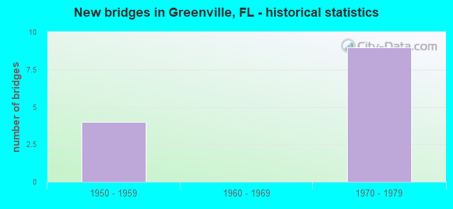
- New bridges - historical statistics
- 41950-1959
- 91970-1979


- Bridge Condition - Deck
- 66.7%Good
- 33.3%Satisfactory

- Bridge Condition - Superstructure
- 33.3%Good
- 66.7%Satisfactory

- Bridge Condition - Channel
- 16.7%Excellent
- 83.3%Good

- Bridge Condition - Culverts
- 16.7%Good
- 66.7%Satisfactory
- 16.7%Fair
Find on map >> Show street view
Structure Number: 350003, Location: 1 MI N OF US 90 (SR 10) (Lat: 30.485000, Lng: -83.593333), Route carried "on" structure: County highway 150, Year Built: 1950, Status: Open, Structure Length: 0.77m (2.53ft), Average Daily Traffic: 550 (year 2021), Truck Traffic: 6%, Average Future Daily Traffic: 954 (year 2042), Design Load: HS 20, Features Intersected: REDDING CREEK
Minimum Vertical Clearance: 30+ m (98+ ft), Kilometerpoint: 1.642, Lanes on structure: 2, Owner: County Highway Agency, Approaching Roadway Width: 6.7m (22.0ft), Material/Design: Concrete, Design/Construction: Culvert, Number Of Spans In Main Unit: 3, Length of Maximum Span: 2.7m (8.9ft)
Condition: Channel: Good, Culverts: Good, Operating Rating: 67.0 metric tons, Method Used To Determine Operating Rating: Load Factor (LF), Inventory Rating: 40.2 metric tons, Method Used To Determine Inventory Rating: Load Factor (LF), Structural Evaluation: Better than present minimum criteria, Waterway Adequacy: Better than present minimum criteria, Approach Roadway Alignment: Equal to present desirable criteria, Designated Inspection Frequency: Every 24 months, Inspection Date: December 2021
Find on map >> Show street view
Structure Number: 350018, Location: 4.1 MI.S.OF JEFFERSON CO. (Lat: 30.505747, Lng: -83.632831), Route carried "on" structure: US 221, Year Built: 1955, Status: Open, Structure Length: 0.94m (3.08ft), Average Daily Traffic: 1,100 (year 2020), Truck Traffic: 17%, Average Future Daily Traffic: 1,908 (year 2042), Design Load: HS 20, Features Intersected: LITTLE AUCILLA RIVER
Minimum Vertical Clearance: 30+ m (98+ ft), Kilometerpoint: 24.499, Lanes on structure: 2, Base Highway Network: Yes, Owner: State Highway Agency, Approaching Roadway Width: 10.5m (34.4ft), Material/Design: Concrete, Design/Construction: Culvert, Number Of Spans In Main Unit: 3, Length of Maximum Span: 3.0m (9.8ft)
Condition: Channel: Good, Culverts: Fair, Operating Rating: 60.1 metric tons, Method Used To Determine Operating Rating: Load Factor (LF), Inventory Rating: 35.9 metric tons, Method Used To Determine Inventory Rating: Load Factor (LF), Structural Evaluation: Somewhat better than minimum adequacy, Waterway Adequacy: Equal to present desirable criteria, Approach Roadway Alignment: Equal to present desirable criteria, Designated Inspection Frequency: Every 24 months, Inspection Date: April 2021
Find on map >> Show street view
Structure Number: 350019, Location: 3.8 MI.S.OF JEFFERSON CO. (Lat: 30.512142, Lng: -83.632939), Route carried "on" structure: US 221, Year Built: 1955, Status: Open, Structure Length: 0.96m (3.15ft), Average Daily Traffic: 1,100 (year 2020), Truck Traffic: 17%, Average Future Daily Traffic: 1,908 (year 2042), Design Load: HS 20, Features Intersected: LITTLE AUCILLA RIVER
Minimum Vertical Clearance: 30+ m (98+ ft), Kilometerpoint: 24.954, Lanes on structure: 2, Base Highway Network: Yes, Owner: State Highway Agency, Approaching Roadway Width: 10.5m (34.4ft), Material/Design: Concrete, Design/Construction: Culvert, Number Of Spans In Main Unit: 3, Length of Maximum Span: 3.1m (10.2ft)
Condition: Channel: Good, Culverts: Satisfactory, Operating Rating: 65.5 metric tons, Method Used To Determine Operating Rating: Load Factor (LF), Inventory Rating: 38.2 metric tons, Method Used To Determine Inventory Rating: Load Factor (LF), Structural Evaluation: Equal to present minimum criteria, Waterway Adequacy: Equal to present desirable criteria, Approach Roadway Alignment: Equal to present desirable criteria, Designated Inspection Frequency: Every 24 months, Inspection Date: April 2021
Find on map >> Show street view
Structure Number: 350031, Location: 2.4 MI WEST OF CR 150 (Lat: 30.503472, Lng: -83.627111), Route carried "on" structure: County highway 140, Year Built: 1955, Status: Open, Structure Length: 0.95m (3.12ft), Average Daily Traffic: 151 (year 2021), Truck Traffic: 10%, Average Future Daily Traffic: 262 (year 2042), Features Intersected: TRIB LITTLE AUCILLA RVR
Minimum Vertical Clearance: 30+ m (98+ ft), Kilometerpoint: 3.880, Lanes on structure: 2, Owner: County Highway Agency, Approaching Roadway Width: 6.1m (20.0ft), Material/Design: Concrete, Design/Construction: Culvert, Number Of Spans In Main Unit: 3, Length of Maximum Span: 3.3m (10.8ft)
Condition: Channel: Good, Culverts: Satisfactory, Operating Rating: 65.3 metric tons, Method Used To Determine Operating Rating: Load and Resistance Factor (LRFR), Inventory Rating: 42.1 metric tons, Method Used To Determine Inventory Rating: Load and Resistance Factor (LRFR), Structural Evaluation: Equal to present minimum criteria, Waterway Adequacy: Equal to present minimum criteria, Approach Roadway Alignment: Equal to present desirable criteria, Designated Inspection Frequency: Every 24 months, Inspection Date: December 2021
Find on map >> Show street view
Structure Number: 350039, Location: I-10 WB / CR-150 & SGRR (Lat: 30.438056, Lng: -83.652222), Route carried "on" structure: Interstate 10, Year Built: 1972, Status: Open, Structure Length: 7.65m (25.10ft), Average Daily Traffic: 10,500 (year 2020), Truck Traffic: 28%, Average Future Daily Traffic: 18,218 (year 2042), Design Load: H 15, Features Intersected: CR-150 & SG RR
Minimum Vertical Clearance: 30+ m (98+ ft), Kilometerpoint: 7.046, Lanes on structure: 2, Lanes under structure: 2, Base Highway Network: Yes, Owner: State Highway Agency, Approaching Roadway Width: 11.9m (39.0ft), Material/Design: Prestressed concrete, Design/Construction: Stringer/Multi-beam, Number Of Spans In Main Unit: 5, Length of Maximum Span: 15.8m (51.8ft), Curb-To-Curb Width: 12.0m (39.4ft), Out-to-Out Width: 12.8m (42.0ft)
Condition: Deck: Satisfactory, Superstructure: Good, Substructure: Good, Operating Rating: 43.4 metric tons, Method Used To Determine Operating Rating: Load and Resistance Factor (LRFR), Inventory Rating: 30.1 metric tons, Method Used To Determine Inventory Rating: Load and Resistance Factor (LRFR), Structural Evaluation: Better than present minimum criteria, Deck Geometry: Equal to present minimum criteria, Underclear: Superior to present desirable criteria, Approach Roadway Alignment: Equal to present desirable criteria, Designated Inspection Frequency: Every 24 months, Inspection Date: January 2021, Deck Structure Type: Concrete Cast-file-Place
Find on map >> Show street view
Structure Number: 350042, Location: 2.2 MI. E. OF SR-55 (Lat: 30.430833, Lng: -83.590556), Route carried "on" structure: Interstate 10, Year Built: 1973, Status: Open, Structure Length: 2.12m (6.96ft), Average Daily Traffic: 17,000 (year 2020), Truck Traffic: 28%, Average Future Daily Traffic: 29,495 (year 2042), Design Load: HS 20+Mod, Features Intersected: CEDAR CREEK
Minimum Vertical Clearance: 30+ m (98+ ft), Kilometerpoint: 13.079, Lanes on structure: 4, Base Highway Network: Yes, Owner: State Highway Agency, Approaching Roadway Width: 23.5m (77.1ft), Skew: 10 degrees, Material/Design: Concrete, Design/Construction: Culvert, Number Of Spans In Main Unit: 6, Length of Maximum Span: 3.4m (11.2ft)
Condition: Channel: Good, Culverts: Satisfactory, Structural Evaluation: Equal to present minimum criteria, Waterway Adequacy: Better than present minimum criteria, Approach Roadway Alignment: Equal to present desirable criteria, Designated Inspection Frequency: Every 24 months, Underwater Inspection Frequency: Every 23 months, Inspection Date: July 2020, Underwater Inspection Date: August 2020
Find on map >> Show street view
Structure Number: 350057, Location: I-10 EB OVER US-221 (Lat: 30.433456, Lng: -83.626711), Route carried "on" structure: Interstate 10, Year Built: 1972, Status: Open, Structure Length: 6.22m (20.41ft), Average Daily Traffic: 10,500 (year 2020), Truck Traffic: 28%, Average Future Daily Traffic: 18,218 (year 2042), Design Load: HS 20+Mod, Features Intersected: US-221 (SR-55)
Minimum Vertical Clearance: 30+ m (98+ ft), Kilometerpoint: 9.584, Lanes on structure: 2, Lanes under structure: 2, Base Highway Network: Yes, Owner: State Highway Agency, Approaching Roadway Width: 12.0m (39.4ft), Skew: 1 degrees, Material/Design: Prestressed concrete, Design/Construction: Stringer/Multi-beam, Number Of Spans In Main Unit: 4, Length of Maximum Span: 19.5m (64.0ft), Curb-To-Curb Width: 12.0m (39.4ft), Out-to-Out Width: 13.0m (42.7ft)
Condition: Deck: Good, Superstructure: Satisfactory, Substructure: Good, Operating Rating: 50.1 metric tons, Method Used To Determine Operating Rating: Load Factor (LF), Inventory Rating: 29.9 metric tons, Method Used To Determine Inventory Rating: Load Factor (LF), Structural Evaluation: Equal to present minimum criteria, Deck Geometry: Equal to present minimum criteria, Underclear: Equal to present minimum criteria, Approach Roadway Alignment: Equal to present desirable criteria, Designated Inspection Frequency: Every 24 months, Inspection Date: July 2020, Deck Structure Type: Concrete Cast-file-Place
Find on map >> Show street view
Structure Number: 35094, Location: I-10 WB OVER US-221 (Lat: 30.433717, Lng: -83.626731), Route carried "on" structure: Interstate 10, Year Built: 1972, Status: Open, Structure Length: 6.22m (20.41ft), Average Daily Traffic: 10,500 (year 2020), Truck Traffic: 28%, Average Future Daily Traffic: 18,218 (year 2042), Design Load: HS 20+Mod, Features Intersected: US-221 (SR-55)
Minimum Vertical Clearance: 30+ m (98+ ft), Kilometerpoint: 9.584, Lanes on structure: 2, Lanes under structure: 2, Base Highway Network: Yes, Owner: State Highway Agency, Approaching Roadway Width: 12.0m (39.4ft), Skew: 1 degrees, Material/Design: Prestressed concrete, Design/Construction: Stringer/Multi-beam, Number Of Spans In Main Unit: 4, Length of Maximum Span: 19.5m (64.0ft), Curb-To-Curb Width: 12.0m (39.4ft), Out-to-Out Width: 13.0m (42.7ft)
Condition: Deck: Good, Superstructure: Satisfactory, Substructure: Good, Operating Rating: 49.0 metric tons, Method Used To Determine Operating Rating: Load Factor (LF), Inventory Rating: 29.0 metric tons, Method Used To Determine Inventory Rating: Load Factor (LF), Structural Evaluation: Equal to present minimum criteria, Deck Geometry: Equal to present minimum criteria, Underclear: Equal to present minimum criteria, Approach Roadway Alignment: Equal to present desirable criteria, Designated Inspection Frequency: Every 24 months, Inspection Date: July 2020, Deck Structure Type: Concrete Cast-file-Place
Find on map >> Show street view
Structure Number: 350941, Location: 2 MI. E. OF US-221 (Lat: 30.431089, Lng: -83.594733), Route carried "on" structure: Interstate 10, Year Built: 1973, Status: Open, Structure Length: 0.70m (2.30ft), Average Daily Traffic: 17,000 (year 2020), Truck Traffic: 28%, Average Future Daily Traffic: 29,495 (year 2042), Design Load: HS 20+Mod, Features Intersected: HIXTOWN SWAMP EQUALIZER
Minimum Vertical Clearance: 30+ m (98+ ft), Kilometerpoint: 12.690, Lanes on structure: 4, Base Highway Network: Yes, Owner: State Highway Agency, Approaching Roadway Width: 12.2m (40.0ft), Skew: 10 degrees, Material/Design: Concrete, Design/Construction: Culvert, Number Of Spans In Main Unit: 2, Length of Maximum Span: 3.4m (11.2ft)
Condition: Channel: Excellent, Culverts: Satisfactory, Structural Evaluation: Equal to present minimum criteria, Waterway Adequacy: Better than present minimum criteria, Approach Roadway Alignment: Equal to present desirable criteria, Designated Inspection Frequency: Every 24 months, Inspection Date: March 2021
Find on map >> Show street view
Structure Number: 350039, Location: I-10 WB / CR-150 & SGRR (Lat: 30.438056, Lng: -83.652222), Route carried "under" structure: County highway 150, Year Built: 1972, Structure Length: 0. m, Average Daily Traffic: 700 (year 2020), Truck Traffic: 9%, Features Intersected: CR-150 & SG RR, Facility Carried by Structure: I-10 WB SR-8
Minimum Vertical Clearance: 6.58m (21.59ft), Kilometerpoint: 20.265, Lanes on structure: 2, Lanes under structure: 2, Material/Design: Prestressed concrete, Design/Construction: Stringer/Multi-beam, Length of Maximum Span: 15.8m (51.8ft)
Find on map >> Show street view
Structure Number: 350056, Location: I-10 EB / CR-150 & SGRR (Lat: 30.437692, Lng: -83.652686), Route carried "under" structure: County highway 150, Year Built: 1972, Structure Length: 0. m, Average Daily Traffic: 700 (year 2020), Truck Traffic: 9%, Features Intersected: CR-150 & SG RR, Facility Carried by Structure: I-10 EB SR-8
Minimum Vertical Clearance: 6.89m (22.60ft), Kilometerpoint: 20.205, Lanes on structure: 2, Lanes under structure: 2, Material/Design: Prestressed concrete, Design/Construction: Stringer/Multi-beam, Length of Maximum Span: 17.1m (56.1ft)
Find on map >> Show street view
Structure Number: 350057, Location: I-10 EB OVER US-221 (Lat: 30.433456, Lng: -83.626711), Route carried "under" structure: US 221, Year Built: 1972, Structure Length: 0. m, Average Daily Traffic: 1,200 (year 2020), Truck Traffic: 17%, Features Intersected: US-221 (SR-55), Facility Carried by Structure: I-10 EB (SR-8)
Minimum Vertical Clearance: 4.82m (15.81ft), Kilometerpoint: 15.659, Lanes on structure: 2, Lanes under structure: 2, Material/Design: Prestressed concrete, Design/Construction: Stringer/Multi-beam, Length of Maximum Span: 19.5m (64.0ft)
Find on map >> Show street view
Structure Number: 35094, Location: I-10 WB OVER US-221 (Lat: 30.433717, Lng: -83.626731), Route carried "under" structure: US 221, Year Built: 1972, Structure Length: 0. m, Average Daily Traffic: 1,200 (year 2020), Truck Traffic: 17%, Features Intersected: US-221 (SR-55), Facility Carried by Structure: I-10 WB (SR-8)
Minimum Vertical Clearance: 4.72m (15.49ft), Kilometerpoint: 15.696, Lanes on structure: 2, Lanes under structure: 2, Material/Design: Prestressed concrete, Design/Construction: Stringer/Multi-beam, Length of Maximum Span: 19.5m (64.0ft)