Bridge Statistics for Greenup, Illinois (IL)
Condition, Traffic, Stress, Structural Evaluation, Project Costs
- National Bridge Inventory (NBI) Statistics
- 32Number of bridges
- 463ft / 141mTotal length
- $5,518,000Total costs
- 141,600Total average daily traffic
- 64,489Total average daily truck traffic
- National Bridge Inventory (NBI) Registered Bridges for Greenup
- No street view available for this location
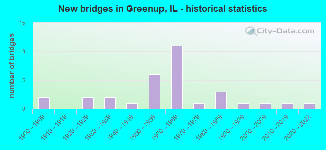
- New bridges - historical statistics
- 21900-1909
- 21920-1929
- 21930-1939
- 11940-1949
- 61950-1959
- 111960-1969
- 11970-1979
- 31980-1989
- 11990-1999
- 12000-2009
- 12010-2019
- 12020-2022

- Reconstructed bridges - Historical Statistics
- 11980-1989
- 31990-1999


- Bridge Condition - Deck
- 5.0%Excellent
- 5.0%Very good
- 20.0%Good
- 35.0%Satisfactory
- 30.0%Fair
- 5.0%Poor

- Bridge Condition - Superstructure
- 5.0%Excellent
- 10.0%Very good
- 15.0%Good
- 30.0%Satisfactory
- 30.0%Fair
- 10.0%Poor

- Bridge Condition - Substructure
- 5.0%Excellent
- 10.0%Very good
- 30.0%Good
- 35.0%Satisfactory
- 15.0%Fair
- 5.0%Poor

- Bridge Condition - Channel
- 17.6%Very good
- 52.9%Good
- 23.5%Satisfactory
- 5.9%Fair

- Bridge Condition - Culverts
- 50.0%Very good
- 25.0%Good
- 25.0%Fair
Find on map >> Show street view
Structure Number: 180008, Location: .7 MI W OF GREENUP (Lat: 39.237292, Lng: -88.187233), Route carried "on" structure: US 40, Year Built: 1950, Status: Open, Structure Length: 13.92m (45.67ft), Average Daily Traffic: 1,400 (year 2021), Truck Traffic: 11%, Average Future Daily Traffic: 1,310 (year 2032), Design Load: HS 20, Features Intersected: EMBARRAS RIVER
Minimum Vertical Clearance: 30+ m (98+ ft), Kilometerpoint: 195.337, Lanes on structure: 2, Owner: State Highway Agency, Approaching Roadway Width: 7.3m (24.0ft), Skew: 1 degrees, Material/Design: Steel continuous, Design/Construction: Stringer/Multi-beam, Number Of Spans In Main Unit: 6, Length of Maximum Span: 26.9m (88.3ft), Curb-To-Curb Width: 7.9m (25.9ft), Out-to-Out Width: 9.8m (32.2ft)
Condition: Deck: Fair, Superstructure: Poor, Substructure: Fair, Channel: Good, Operating Rating: 53.5 metric tons, Method Used To Determine Operating Rating: Load Factor (LF) rating reported by rating factor (RF) method using MS18 loading, Inventory Rating: 32.1 metric tons, Method Used To Determine Inventory Rating: Load Factor (LF) rating reported by rating factor (RF) method using MS18 loading, Structural Evaluation: Meets minimum limits, Deck Geometry: Meets minimum limits, Waterway Adequacy: Equal to present desirable criteria, Approach Roadway Alignment: Equal to present desirable criteria, Length Of Structure Improvement: 13.93m (45.70ft), Designated Inspection Frequency: Every 12 months, Underwater Inspection Frequency: Every 12 months, Inspection Date: March 2021, Underwater Inspection Date: May 2021, Bridge Improvement Cost: $1,759,000, Roadway Improvement Cost: $293,000, Total Project Cost: $2,052,000, Deck Structure Type: Concrete Cast-file-Place, Wearing Surface/Protective System: Wearing Surface: Bituminous, Membrane: Built-up
Find on map >> Show street view
Structure Number: 180009, Location: GREENUP (Lat: 39.240064, Lng: -88.171281), Route carried "on" structure: US 40, Year Built: 1950, Year Reconstructed: 1990, Status: Open, Structure Length: 5.29m (17.36ft), Average Daily Traffic: 1,400 (year 2021), Truck Traffic: 11%, Average Future Daily Traffic: 1,310 (year 2032), Design Load: HS 20+Mod, Features Intersected: MILL ROAD(MS 5990)
Minimum Vertical Clearance: 30+ m (98+ ft), Kilometerpoint: 196.753, Lanes on structure: 2, Lanes under structure: 2, Owner: State Highway Agency, Approaching Roadway Width: 7.3m (24.0ft), Skew: 2 degrees, Material/Design: Steel continuous, Design/Construction: Stringer/Multi-beam, Number Of Spans In Main Unit: 3, Length of Maximum Span: 22.6m (74.1ft), Curb-To-Curb Width: 9.1m (29.9ft), Out-to-Out Width: 10.1m (33.1ft)
Condition: Deck: Fair, Superstructure: Fair, Substructure: Fair, Operating Rating: 85.2 metric tons, Method Used To Determine Operating Rating: Load Factor (LF) rating reported by rating factor (RF) method using MS18 loading, Inventory Rating: 43.4 metric tons, Method Used To Determine Inventory Rating: Load Factor (LF) rating reported by rating factor (RF) method using MS18 loading, Structural Evaluation: Somewhat better than minimum adequacy, Deck Geometry: Somewhat better than minimum adequacy, Underclear: Better than present minimum criteria, Approach Roadway Alignment: Equal to present desirable criteria, Designated Inspection Frequency: Every 24 months, Inspection Date: May 2020, Deck Structure Type: Concrete Cast-file-Place, Wearing Surface/Protective System: Deck Protection: Epoxy Coated Reinforcing
Find on map >> Show street view
Structure Number: 18001, Location: GREENUP (Lat: 39.240861, Lng: -88.168881), Route carried "on" structure: US 40, Year Built: 1950, Year Reconstructed: 1990, Status: Open, Structure Length: 5.35m (17.55ft), Average Daily Traffic: 1,400 (year 2021), Truck Traffic: 11%, Average Future Daily Traffic: 1,310 (year 2032), Design Load: HS 20, Features Intersected: LINCOLN ST(MS 1230)
Minimum Vertical Clearance: 30+ m (98+ ft), Kilometerpoint: 196.978, Lanes on structure: 2, Lanes under structure: 2, Owner: State Highway Agency, Approaching Roadway Width: 7.3m (24.0ft), Skew: 2 degrees, Material/Design: Steel continuous, Design/Construction: Stringer/Multi-beam, Number Of Spans In Main Unit: 3, Length of Maximum Span: 20.4m (66.9ft), Curb-To-Curb Width: 9.1m (29.9ft), Out-to-Out Width: 10.1m (33.1ft)
Condition: Deck: Fair, Superstructure: Fair, Substructure: Satisfactory, Operating Rating: 74.2 metric tons, Method Used To Determine Operating Rating: Load Factor (LF) rating reported by rating factor (RF) method using MS18 loading, Inventory Rating: 38.2 metric tons, Method Used To Determine Inventory Rating: Load Factor (LF) rating reported by rating factor (RF) method using MS18 loading, Structural Evaluation: Somewhat better than minimum adequacy, Deck Geometry: Somewhat better than minimum adequacy, Underclear: Superior to present desirable criteria, Approach Roadway Alignment: Equal to present desirable criteria, Designated Inspection Frequency: Every 24 months, Inspection Date: April 2021, Deck Structure Type: Concrete Cast-file-Place, Wearing Surface/Protective System: Deck Protection: Epoxy Coated Reinforcing
Find on map >> Show street view
Structure Number: 180019, Location: NW CL GREENUP (Lat: 39.251389, Lng: -88.173750), Route carried "on" structure: State highway 121, Year Built: 1960, Year Reconstructed: 1995, Status: Open, Structure Length: 9.10m (29.86ft), Average Daily Traffic: 3,450 (year 2021), Truck Traffic: 6%, Average Future Daily Traffic: 3,825 (year 2032), Design Load: HS 20, Features Intersected: EMBARRAS RIVER
Minimum Vertical Clearance: 30+ m (98+ ft), Kilometerpoint: 2.156, Lanes on structure: 2, Base Highway Network: Yes, Owner: State Highway Agency, Approaching Roadway Width: 9.8m (32.2ft), Material/Design: Steel continuous, Design/Construction: Stringer/Multi-beam, Number Of Spans In Main Unit: 4, Length of Maximum Span: 25.2m (82.7ft), Curb-To-Curb Width: 9.8m (32.2ft), Out-to-Out Width: 10.7m (35.1ft)
Condition: Deck: Satisfactory, Superstructure: Fair, Substructure: Satisfactory, Channel: Good, Operating Rating: 82.6 metric tons, Method Used To Determine Operating Rating: Load Factor (LF) rating reported by rating factor (RF) method using MS18 loading, Inventory Rating: 49.6 metric tons, Method Used To Determine Inventory Rating: Load Factor (LF) rating reported by rating factor (RF) method using MS18 loading, Structural Evaluation: Somewhat better than minimum adequacy, Deck Geometry: Meets minimum limits, Waterway Adequacy: Equal to present desirable criteria, Approach Roadway Alignment: Equal to present desirable criteria, Designated Inspection Frequency: Every 24 months, Inspection Date: August 2020, Deck Structure Type: Concrete Cast-file-Place, Wearing Surface/Protective System: Deck Protection: Epoxy Coated Reinforcing
Find on map >> Show street view
Structure Number: 180021, Location: .5 MI W OF GREENUP (Lat: 39.240611, Lng: -88.181533), Route carried "on" structure: County highway , Year Built: 1920, Status: Posted for load, Structure Length: 2.62m (8.60ft), Average Daily Traffic: 200 (year 2021), Truck Traffic: 1%, Average Future Daily Traffic: 524 (year 2032), Design Load: H 15, Features Intersected: EMBARRAS R OVERFLOW, Facility Carried by Structure: SBI 11 A
Minimum Vertical Clearance: 30+ m (98+ ft), Kilometerpoint: 1.481, Lanes on structure: 2, Owner: County Highway Agency, Approaching Roadway Width: 5.5m (18.0ft), Material/Design: Concrete, Number Of Spans In Main Unit: 2, Length of Maximum Span: 12.5m (41.0ft), Curb-To-Curb Width: 5.9m (19.4ft), Out-to-Out Width: 7.3m (24.0ft)
Condition: Deck: Poor, Superstructure: Poor, Substructure: Poor, Channel: Satisfactory, Operating Rating: 27.2 metric tons, Method Used To Determine Operating Rating: Load Factor (LF) rating reported by rating factor (RF) method using MS18 loading, Inventory Rating: 12.0 metric tons, Method Used To Determine Inventory Rating: Load Factor (LF) rating reported by rating factor (RF) method using MS18 loading, Structural Evaluation: Meets minimum limits, Deck Geometry: High priority of corrective action, Waterway Adequacy: Equal to present desirable criteria, Approach Roadway Alignment: Better than present minimum criteria, Bridge Posting: Required (Relationship of Operating Rating to Maximum Legal Load: > 39.9% below), Length Of Structure Improvement: 2.62m (8.60ft), Designated Inspection Frequency: Every 24 months, Other Special Inspection Frequency: Every 12 months, Inspection Date: January 2022, Other Special Inspection Date: January 2022, Bridge Improvement Cost: $722,000, Roadway Improvement Cost: $83,000, Total Project Cost: $805,000, Deck Structure Type: Concrete Cast-file-Place, Wearing Surface/Protective System: Wearing Surface: Bituminous, Membrane: Built-up
Find on map >> Show street view
Structure Number: 180024, Location: N EDGE OF GREENUP (Lat: 39.263839, Lng: -88.150503), Route carried "on" structure: State highway 130, Year Built: 1931, Status: Open, Structure Length: 0.79m (2.59ft), Average Daily Traffic: 2,950 (year 2021), Truck Traffic: 18%, Average Future Daily Traffic: 3,249 (year 2032), Design Load: H 15, Features Intersected: BELL BRANCH
Minimum Vertical Clearance: 30+ m (98+ ft), Kilometerpoint: 116.867, Lanes on structure: 2, Base Highway Network: Yes, Owner: State Highway Agency, Approaching Roadway Width: 7.9m (25.9ft), Material/Design: Concrete, Design/Construction: Slab, Number Of Spans In Main Unit: 1, Length of Maximum Span: 7.6m (24.9ft), Curb-To-Curb Width: 10.4m (34.1ft), Out-to-Out Width: 17.4m (57.1ft)
Condition: Deck: Satisfactory, Superstructure: Satisfactory, Substructure: Satisfactory, Channel: Good, Operating Rating: 89.1 metric tons, Method Used To Determine Operating Rating: Allowable Stress (AS) rating reported by rating factor (RF) method using MS18 loading, Inventory Rating: 41.5 metric tons, Method Used To Determine Inventory Rating: Allowable Stress (AS) rating reported by rating factor (RF) method using MS18 loading, Structural Evaluation: Equal to present minimum criteria, Deck Geometry: Somewhat better than minimum adequacy, Waterway Adequacy: Equal to present desirable criteria, Approach Roadway Alignment: Equal to present desirable criteria, Designated Inspection Frequency: Every 24 months, Other Special Inspection Frequency: Every 12 months, Inspection Date: Febuary 2022, Other Special Inspection Date: November 2021, Deck Structure Type: Concrete Cast-file-Place
Find on map >> Show street view
Structure Number: 180025, Location: GREENUP INT (Lat: 39.255311, Lng: -88.153650), Route carried "on" structure: State highway 130, Year Built: 1969, Status: Open, Structure Length: 7.25m (23.79ft), Average Daily Traffic: 4,800 (year 2021), Truck Traffic: 29%, Average Future Daily Traffic: 4,506 (year 2032), Design Load: HS 20, Features Intersected: I-70
Minimum Vertical Clearance: 30+ m (98+ ft), Kilometerpoint: 115.934, Lanes on structure: 2, Lanes under structure: 4, Base Highway Network: Yes, Owner: State Highway Agency, Approaching Roadway Width: 11.0m (36.1ft), Skew: 31 degrees, Material/Design: Steel continuous, Design/Construction: Stringer/Multi-beam, Number Of Spans In Main Unit: 4, Length of Maximum Span: 22.1m (72.5ft), Curb-To-Curb Width: 11.0m (36.1ft), Out-to-Out Width: 17.7m (58.1ft)
Condition: Deck: Fair, Superstructure: Fair, Substructure: Satisfactory, Operating Rating: 71.6 metric tons, Method Used To Determine Operating Rating: Load Factor (LF) rating reported by rating factor (RF) method using MS18 loading, Inventory Rating: 42.4 metric tons, Method Used To Determine Inventory Rating: Load Factor (LF) rating reported by rating factor (RF) method using MS18 loading, Structural Evaluation: Somewhat better than minimum adequacy, Deck Geometry: Somewhat better than minimum adequacy, Underclear: Meets minimum limits, Approach Roadway Alignment: Equal to present desirable criteria, Designated Inspection Frequency: Every 24 months, Inspection Date: May 2021, Deck Structure Type: Concrete Cast-file-Place, Wearing Surface/Protective System: Wearing Surface: Other
Find on map >> Show street view
Structure Number: 180026, Location: .5 MI S US 40 (Lat: 39.242661, Lng: -88.154994), Route carried "on" structure: State highway 130, Year Built: 1931, Year Reconstructed: 1980, Status: Open, Structure Length: 3.90m (12.80ft), Average Daily Traffic: 3,200 (year 2021), Truck Traffic: 18%, Average Future Daily Traffic: 3,144 (year 2032), Design Load: HS 20, Features Intersected: CSXT RR
Minimum Vertical Clearance: 30+ m (98+ ft), Kilometerpoint: 114.453, Lanes on structure: 2, Base Highway Network: Yes, Owner: State Highway Agency, Approaching Roadway Width: 7.9m (25.9ft), Skew: 1 degrees, Material/Design: Steel, Design/Construction: Stringer/Multi-beam, Number Of Spans In Main Unit: 3, Length of Maximum Span: 13.7m (44.9ft), Curb-To-Curb Width: 9.8m (32.2ft), Out-to-Out Width: 10.7m (35.1ft)
Condition: Deck: Satisfactory, Superstructure: Satisfactory, Substructure: Fair, Operating Rating: 54.1 metric tons, Method Used To Determine Operating Rating: Allowable Stress (AS) rating reported by rating factor (RF) method using MS18 loading, Inventory Rating: 33.4 metric tons, Method Used To Determine Inventory Rating: Allowable Stress (AS) rating reported by rating factor (RF) method using MS18 loading, Structural Evaluation: Somewhat better than minimum adequacy, Deck Geometry: Meets minimum limits, Underclear: Somewhat better than minimum adequacy, Approach Roadway Alignment: Equal to present desirable criteria, Designated Inspection Frequency: Every 24 months, Inspection Date: June 2021, Deck Structure Type: Concrete Cast-file-Place, Wearing Surface/Protective System: Deck Protection: Epoxy Coated Reinforcing
Find on map >> Show street view
Structure Number: 180038, Location: 2 MI NE OF GREENUP (Lat: 39.273078, Lng: -88.109675), Route carried "on" structure: County highway , Year Built: 1969, Status: Open, Structure Length: 7.24m (23.75ft), Average Daily Traffic: 125 (year 2021), Truck Traffic: 3%, Average Future Daily Traffic: 210 (year 2032), Design Load: HS 15, Features Intersected: I-70, Facility Carried by Structure: TR 240 A
Minimum Vertical Clearance: 30+ m (98+ ft), Kilometerpoint: 2.591, Lanes on structure: 2, Lanes under structure: 4, Owner: State Highway Agency, Approaching Roadway Width: 5.5m (18.0ft), Skew: 1 degrees, Material/Design: Steel continuous, Design/Construction: Stringer/Multi-beam, Number Of Spans In Main Unit: 4, Length of Maximum Span: 22.2m (72.8ft), Curb-To-Curb Width: 8.1m (26.6ft), Out-to-Out Width: 9.1m (29.9ft)
Condition: Deck: Good, Superstructure: Good, Substructure: Good, Operating Rating: 44.4 metric tons, Method Used To Determine Operating Rating: Load Factor (LF) rating reported by rating factor (RF) method using MS18 loading, Inventory Rating: 26.6 metric tons, Method Used To Determine Inventory Rating: Load Factor (LF) rating reported by rating factor (RF) method using MS18 loading, Structural Evaluation: Equal to present minimum criteria, Deck Geometry: Somewhat better than minimum adequacy, Underclear: Meets minimum limits, Approach Roadway Alignment: Equal to present desirable criteria, Designated Inspection Frequency: Every 24 months, Inspection Date: June 2020, Deck Structure Type: Concrete Cast-file-Place
Find on map >> Show street view
Structure Number: 180047, Location: I-70 OVER IL 121 (Lat: 39.253067, Lng: -88.175000), Route carried "on" structure: Interstate 70, Year Built: 1969, Status: Open, Structure Length: 4.22m (13.85ft), Average Daily Traffic: 13,000 (year 2021), Truck Traffic: 58%, Average Future Daily Traffic: 9,851 (year 2032), Design Load: HS 20+Mod, Features Intersected: IL 121 (FAP 773)
Minimum Vertical Clearance: 30+ m (98+ ft), Kilometerpoint: 196.415, Lanes on structure: 2, Lanes under structure: 2, Base Highway Network: Yes, Owner: State Highway Agency, Approaching Roadway Width: 12.2m (40.0ft), Skew: 2 degrees, Material/Design: Steel continuous, Design/Construction: Stringer/Multi-beam, Number Of Spans In Main Unit: 3, Length of Maximum Span: 15.5m (50.9ft), Curb-To-Curb Width: 11.7m (38.4ft), Out-to-Out Width: 12.8m (42.0ft)
Condition: Deck: Satisfactory, Superstructure: Satisfactory, Substructure: Good, Operating Rating: 96.9 metric tons, Method Used To Determine Operating Rating: Load Factor (LF) rating reported by rating factor (RF) method using MS18 loading, Inventory Rating: 58.0 metric tons, Method Used To Determine Inventory Rating: Load Factor (LF) rating reported by rating factor (RF) method using MS18 loading, Structural Evaluation: Equal to present minimum criteria, Deck Geometry: Equal to present minimum criteria, Underclear: Somewhat better than minimum adequacy, Approach Roadway Alignment: Equal to present desirable criteria, Designated Inspection Frequency: Every 24 months, Inspection Date: July 2020, Deck Structure Type: Concrete Cast-file-Place, Wearing Surface/Protective System: Deck Protection: Epoxy Coated Reinforcing
Find on map >> Show street view
Structure Number: 180048, Location: I-70 OVER IL 121 (Lat: 39.253031, Lng: -88.175169), Route carried "on" structure: Interstate 70, Year Built: 1969, Status: Open, Structure Length: 4.22m (13.85ft), Average Daily Traffic: 13,000 (year 2021), Truck Traffic: 58%, Average Future Daily Traffic: 9,851 (year 2032), Design Load: HS 20+Mod, Features Intersected: IL 121 (FAP 773)
Minimum Vertical Clearance: 30+ m (98+ ft), Kilometerpoint: 196.399, Lanes on structure: 2, Lanes under structure: 2, Base Highway Network: Yes, Owner: State Highway Agency, Approaching Roadway Width: 12.2m (40.0ft), Skew: 2 degrees, Material/Design: Steel continuous, Design/Construction: Stringer/Multi-beam, Number Of Spans In Main Unit: 3, Length of Maximum Span: 15.5m (50.9ft), Curb-To-Curb Width: 11.7m (38.4ft), Out-to-Out Width: 12.8m (42.0ft)
Condition: Deck: Satisfactory, Superstructure: Satisfactory, Substructure: Good, Operating Rating: 94.9 metric tons, Method Used To Determine Operating Rating: Load Factor (LF) rating reported by rating factor (RF) method using MS18 loading, Inventory Rating: 56.7 metric tons, Method Used To Determine Inventory Rating: Load Factor (LF) rating reported by rating factor (RF) method using MS18 loading, Structural Evaluation: Equal to present minimum criteria, Deck Geometry: Equal to present minimum criteria, Underclear: Meets minimum limits, Approach Roadway Alignment: Equal to present desirable criteria, Designated Inspection Frequency: Every 24 months, Inspection Date: July 2020, Deck Structure Type: Concrete Cast-file-Place, Wearing Surface/Protective System: Deck Protection: Epoxy Coated Reinforcing
Find on map >> Show street view
Structure Number: 180049, Location: 12 MI E EFF CO LINE (Lat: 39.253686, Lng: -88.170881), Route carried "on" structure: Interstate 70, Year Built: 1969, Status: Open, Structure Length: 20.42m (66.99ft), Average Daily Traffic: 13,000 (year 2021), Truck Traffic: 58%, Average Future Daily Traffic: 9,851 (year 2032), Design Load: HS 20+Mod, Features Intersected: EMBARRAS RIVER
Minimum Vertical Clearance: 30+ m (98+ ft), Kilometerpoint: 196.801, Lanes on structure: 2, Base Highway Network: Yes, Owner: State Highway Agency, Approaching Roadway Width: 12.2m (40.0ft), Material/Design: Steel continuous, Design/Construction: Stringer/Multi-beam, Number Of Spans In Main Unit: 8, Length of Maximum Span: 28.3m (92.8ft), Curb-To-Curb Width: 9.9m (32.5ft), Out-to-Out Width: 11.0m (36.1ft)
Condition: Deck: Fair, Superstructure: Fair, Substructure: Good, Channel: Good, Operating Rating: 71.6 metric tons, Method Used To Determine Operating Rating: Load Factor (LF) rating reported by rating factor (RF) method using MS18 loading, Inventory Rating: 42.8 metric tons, Method Used To Determine Inventory Rating: Load Factor (LF) rating reported by rating factor (RF) method using MS18 loading, Structural Evaluation: Somewhat better than minimum adequacy, Deck Geometry: Meets minimum limits, Waterway Adequacy: Equal to present desirable criteria, Approach Roadway Alignment: Equal to present desirable criteria, Designated Inspection Frequency: Every 24 months, Inspection Date: August 2020, Deck Structure Type: Concrete Cast-file-Place, Wearing Surface/Protective System: Deck Protection: Epoxy Coated Reinforcing
Find on map >> Show street view
Structure Number: 18005, Location: 12 MI E EFF CO LINE (Lat: 39.253669, Lng: -88.171050), Route carried "on" structure: Interstate 70, Year Built: 1969, Status: Open, Structure Length: 20.42m (66.99ft), Average Daily Traffic: 13,000 (year 2021), Truck Traffic: 58%, Average Future Daily Traffic: 9,851 (year 2032), Design Load: HS 20+Mod, Features Intersected: EMBARRAS RIVER
Minimum Vertical Clearance: 30+ m (98+ ft), Kilometerpoint: 196.785, Lanes on structure: 2, Base Highway Network: Yes, Owner: State Highway Agency, Approaching Roadway Width: 12.2m (40.0ft), Material/Design: Steel continuous, Design/Construction: Stringer/Multi-beam, Number Of Spans In Main Unit: 8, Length of Maximum Span: 28.3m (92.8ft), Curb-To-Curb Width: 9.9m (32.5ft), Out-to-Out Width: 11.0m (36.1ft)
Condition: Deck: Fair, Superstructure: Fair, Substructure: Good, Channel: Good, Operating Rating: 71.6 metric tons, Method Used To Determine Operating Rating: Load Factor (LF) rating reported by rating factor (RF) method using MS18 loading, Inventory Rating: 42.8 metric tons, Method Used To Determine Inventory Rating: Load Factor (LF) rating reported by rating factor (RF) method using MS18 loading, Structural Evaluation: Somewhat better than minimum adequacy, Deck Geometry: Meets minimum limits, Waterway Adequacy: Equal to present desirable criteria, Approach Roadway Alignment: Equal to present desirable criteria, Designated Inspection Frequency: Every 24 months, Inspection Date: August 2020, Deck Structure Type: Concrete Cast-file-Place, Wearing Surface/Protective System: Deck Protection: Epoxy Coated Reinforcing
Find on map >> Show street view
Structure Number: 180058, Location: 4.8 MI S OF COLES CO (Lat: 39.307881, Lng: -88.139197), Route carried "on" structure: State highway 130, Year Built: 1982, Status: Open, Structure Length: 10.36m (33.99ft), Average Daily Traffic: 2,500 (year 2021), Truck Traffic: 18%, Average Future Daily Traffic: 3,249 (year 2032), Design Load: HS 20, Features Intersected: HURRICANE CREEK
Minimum Vertical Clearance: 30+ m (98+ ft), Kilometerpoint: 121.904, Lanes on structure: 2, Base Highway Network: Yes, Owner: State Highway Agency, Approaching Roadway Width: 7.9m (25.9ft), Skew: 5 degrees, Material/Design: Steel continuous, Design/Construction: Stringer/Multi-beam, Number Of Spans In Main Unit: 4, Length of Maximum Span: 26.2m (86.0ft), Curb-To-Curb Width: 9.8m (32.2ft), Out-to-Out Width: 10.7m (35.1ft)
Condition: Deck: Satisfactory, Superstructure: Satisfactory, Substructure: Satisfactory, Channel: Good, Operating Rating: 45.7 metric tons, Method Used To Determine Operating Rating: Load Factor (LF) rating reported by rating factor (RF) method using MS18 loading, Inventory Rating: 27.2 metric tons, Method Used To Determine Inventory Rating: Load Factor (LF) rating reported by rating factor (RF) method using MS18 loading, Structural Evaluation: Equal to present minimum criteria, Deck Geometry: Meets minimum limits, Waterway Adequacy: Better than present minimum criteria, Approach Roadway Alignment: Equal to present desirable criteria, Designated Inspection Frequency: Every 24 months, Other Special Inspection Frequency: Every 12 months, Inspection Date: June 2021, Other Special Inspection Date: June 2021, Deck Structure Type: Concrete Cast-file-Place
Find on map >> Show street view
Structure Number: 180064, Location: 7 MI S COLES CO LINE (Lat: 39.275122, Lng: -88.145544), Route carried "on" structure: State highway 130, Year Built: 2010, Status: Open, Structure Length: 5.70m (18.70ft), Average Daily Traffic: 2,950 (year 2021), Truck Traffic: 18%, Average Future Daily Traffic: 3,249 (year 2032), Design Load: HS 25 or greater, Features Intersected: LOST CREEK
Minimum Vertical Clearance: 30+ m (98+ ft), Kilometerpoint: 118.187, Lanes on structure: 2, Base Highway Network: Yes, Owner: State Highway Agency, Approaching Roadway Width: 7.9m (25.9ft), Skew: 4 degrees, Material/Design: Prestressed concrete continuous, Design/Construction: Stringer/Multi-beam, Number Of Spans In Main Unit: 3, Length of Maximum Span: 19.8m (65.0ft), Curb-To-Curb Width: 11.0m (36.1ft), Out-to-Out Width: 11.9m (39.0ft)
Condition: Deck: Good, Superstructure: Very good, Substructure: Very good, Channel: Very good, Operating Rating: 58.6 metric tons, Method Used To Determine Operating Rating: Load and Resistance Factor Rating (LRFR) rating reported by rating factor(RF) method using HL-93 loadings, Inventory Rating: 45.4 metric tons, Method Used To Determine Inventory Rating: Load and Resistance Factor Rating (LRFR) rating reported by rating factor(RF) method using HL-93 loadings, Structural Evaluation: Equal to present desirable criteria, Deck Geometry: Somewhat better than minimum adequacy, Waterway Adequacy: Equal to present desirable criteria, Approach Roadway Alignment: Equal to present desirable criteria, Designated Inspection Frequency: Every 48 months, Inspection Date: March 2021, Deck Structure Type: Concrete Cast-file-Place, Wearing Surface/Protective System: Deck Protection: Epoxy Coated Reinforcing
Find on map >> Show street view
Structure Number: 182002, Location: 3.39 MI E OF GREENUP (Lat: 39.266847, Lng: -88.096308), Route carried "on" structure: US 40, Year Built: 1950, Status: Open, Structure Length: 0.77m (2.53ft), Average Daily Traffic: 2,200 (year 2021), Truck Traffic: 16%, Average Future Daily Traffic: 2,253 (year 2032), Design Load: H 20, Features Intersected: STREAM
Minimum Vertical Clearance: 30+ m (98+ ft), Kilometerpoint: 203.979, Lanes on structure: 2, Base Highway Network: Yes, Owner: State Highway Agency, Approaching Roadway Width: 7.3m (24.0ft), Skew: 3 degrees, Material/Design: Concrete, Design/Construction: Culvert, Number Of Spans In Main Unit: 3, Length of Maximum Span: 2.2m (7.2ft)
Condition: Channel: Fair, Culverts: Fair, Operating Rating: 97.2 metric tons, Method Used To Determine Operating Rating: Load Factor (LF) rating reported by rating factor (RF) method using MS18 loading, Inventory Rating: 61.2 metric tons, Method Used To Determine Inventory Rating: Load Factor (LF) rating reported by rating factor (RF) method using MS18 loading, Structural Evaluation: Somewhat better than minimum adequacy, Waterway Adequacy: Better than present minimum criteria, Approach Roadway Alignment: Equal to present desirable criteria, Designated Inspection Frequency: Every 24 months, Inspection Date: April 2020
Find on map >> Show street view
Structure Number: 182005, Location: 3.5 MI N OF I-70 (Lat: 39.303717, Lng: -88.139092), Route carried "on" structure: State highway 130, Year Built: 1993, Status: Open, Structure Length: 1.38m (4.53ft), Average Daily Traffic: 2,500 (year 2021), Truck Traffic: 18%, Average Future Daily Traffic: 3,249 (year 2032), Design Load: HS 20+Mod, Features Intersected: HURRICANE CREEK
Minimum Vertical Clearance: 30+ m (98+ ft), Kilometerpoint: 121.454, Lanes on structure: 2, Base Highway Network: Yes, Owner: State Highway Agency, Approaching Roadway Width: 10.1m (33.1ft), Skew: 4 degrees, Material/Design: Concrete, Design/Construction: Culvert, Number Of Spans In Main Unit: 3, Length of Maximum Span: 4.3m (14.1ft)
Condition: Channel: Good, Culverts: Good, Operating Rating: 54.8 metric tons, Method Used To Determine Operating Rating: Load Factor (LF) rating reported by rating factor (RF) method using MS18 loading, Inventory Rating: 32.7 metric tons, Method Used To Determine Inventory Rating: Load Factor (LF) rating reported by rating factor (RF) method using MS18 loading, Structural Evaluation: Better than present minimum criteria, Waterway Adequacy: Equal to present desirable criteria, Approach Roadway Alignment: Equal to present desirable criteria, Designated Inspection Frequency: Every 48 months, Inspection Date: September 2018
Find on map >> Show street view
Structure Number: 183008, Location: 3.0 MI SE GREENUP (Lat: 39.208350, Lng: -88.133947), Route carried "on" structure: County highway , Year Built: 1941, Status: Open, Structure Length: 3.95m (12.96ft), Average Daily Traffic: 475 (year 2021), Truck Traffic: 5%, Average Future Daily Traffic: 576 (year 2032), Design Load: H 15, Features Intersected: RANGE CREEK, Facility Carried by Structure: CH 4(FAS 702)
Minimum Vertical Clearance: 30+ m (98+ ft), Kilometerpoint: 1.851, Lanes on structure: 2, Owner: County Highway Agency, Approaching Roadway Width: 6.4m (21.0ft), Material/Design: Steel, Design/Construction: Stringer/Multi-beam, Number Of Spans In Main Unit: 3, Length of Maximum Span: 15.0m (49.2ft), Curb-To-Curb Width: 7.3m (24.0ft), Out-to-Out Width: 7.6m (24.9ft)
Condition: Deck: Good, Superstructure: Satisfactory, Substructure: Good, Channel: Satisfactory, Operating Rating: 36.0 metric tons, Method Used To Determine Operating Rating: Allowable Stress (AS) rating reported by rating factor (RF) method using MS18 loading, Inventory Rating: 24.6 metric tons, Method Used To Determine Inventory Rating: Allowable Stress (AS) rating reported by rating factor (RF) method using MS18 loading, Structural Evaluation: Equal to present minimum criteria, Deck Geometry: Meets minimum limits, Waterway Adequacy: Superior to present desirable criteria, Approach Roadway Alignment: Equal to present desirable criteria, Designated Inspection Frequency: Every 24 months, Inspection Date: Febuary 2021, Deck Structure Type: Concrete Cast-file-Place, Wearing Surface/Protective System: Wearing Surface: Gravel
Find on map >> Show street view
Structure Number: 183073, Location: NE GREENUP W IL 130 (Lat: 39.265536, Lng: -88.152106), Route carried "on" structure: County highway , Year Built: 1922, Status: Open, Structure Length: 1.01m (3.31ft), Average Daily Traffic: 25 (year 2021), Truck Traffic: 8%, Average Future Daily Traffic: 52 (year 2032), Features Intersected: BELL BRANCH, Facility Carried by Structure: TR 212
Minimum Vertical Clearance: 30+ m (98+ ft), Kilometerpoint: 0.435, Lanes on structure: 1, Owner: Town or Township Highway Agency, Approaching Roadway Width: 3.4m (11.2ft), Material/Design: Concrete, Number Of Spans In Main Unit: 1, Length of Maximum Span: 9.6m (31.5ft), Curb-To-Curb Width: 5.2m (17.1ft), Out-to-Out Width: 6.5m (21.3ft)
Condition: Deck: Satisfactory, Superstructure: Good, Substructure: Satisfactory, Channel: Satisfactory, Operating Rating: 32.4 metric tons, Method Used To Determine Operating Rating: Field evaluation and documented engineering judgment, Inventory Rating: 19.4 metric tons, Method Used To Determine Inventory Rating: Field evaluation and documented engineering judgment, Structural Evaluation: Somewhat better than minimum adequacy, Deck Geometry: High priority of corrective action, Waterway Adequacy: Meets minimum limits, Approach Roadway Alignment: Meets minimum limits, Length Of Structure Improvement: 0.79m (2.59ft), Designated Inspection Frequency: Every 24 months, Inspection Date: Febuary 2021, Bridge Improvement Cost: $246,000, Roadway Improvement Cost: $28,000, Total Project Cost: $274,000, Deck Structure Type: Concrete Cast-file-Place
Find on map >> Show street view
Structure Number: 183101, Location: 2.5 MI E GREENUP (Lat: 39.245658, Lng: -88.095817), Route carried "on" structure: County highway , Year Built: 1977, Status: Open, Structure Length: 1.64m (5.38ft), Average Daily Traffic: 150 (year 2021), Truck Traffic: 6%, Average Future Daily Traffic: 262 (year 2032), Design Load: HS 20, Features Intersected: RANGE CREEK, Facility Carried by Structure: FAS 654(CH 11)
Minimum Vertical Clearance: 30+ m (98+ ft), Kilometerpoint: 5.101, Lanes on structure: 2, Owner: County Highway Agency, Approaching Roadway Width: 8.5m (27.9ft), Skew: 3 degrees, Material/Design: Concrete, Design/Construction: Culvert, Number Of Spans In Main Unit: 3, Length of Maximum Span: 5.6m (18.4ft), Curb-To-Curb Width: 8.5m (27.9ft), Out-to-Out Width: 9.1m (29.9ft)
Condition: Channel: Good, Culverts: Very good, Operating Rating: 44.4 metric tons, Method Used To Determine Operating Rating: Assigned rating based on Load Factor Design (LFD) reported by rating factor (RF) using MS18 loading, Inventory Rating: 32.4 metric tons, Method Used To Determine Inventory Rating: Assigned rating based on Load Factor Design (LFD) reported by rating factor (RF) using MS18 loading, Structural Evaluation: Equal to present desirable criteria, Deck Geometry: Equal to present minimum criteria, Waterway Adequacy: Equal to present minimum criteria, Approach Roadway Alignment: Equal to present minimum criteria, Designated Inspection Frequency: Every 48 months, Inspection Date: December 2019
Find on map >> Show street view
Structure Number: 183139, Location: 3.0 MI SE GREENUP (Lat: 39.223053, Lng: -88.121131), Route carried "on" structure: County highway , Year Built: 1980, Status: Open, Structure Length: 2.19m (7.19ft), Average Daily Traffic: 50 (year 2021), Truck Traffic: 4%, Average Future Daily Traffic: 105 (year 2032), Design Load: HS 20+Mod, Features Intersected: RANGE CREEK, Facility Carried by Structure: TR 187
Minimum Vertical Clearance: 30+ m (98+ ft), Kilometerpoint: 4.039, Lanes on structure: 2, Owner: Town or Township Highway Agency, Approaching Roadway Width: 5.5m (18.0ft), Skew: 2 degrees, Material/Design: Prestressed concrete, Design/Construction: Box Beam or Girders - Multiple, Number Of Spans In Main Unit: 1, Length of Maximum Span: 21.2m (69.6ft), Curb-To-Curb Width: 8.2m (26.9ft), Out-to-Out Width: 8.3m (27.2ft)
Condition: Deck: Good, Superstructure: Good, Substructure: Satisfactory, Channel: Good, Operating Rating: 44.4 metric tons, Method Used To Determine Operating Rating: Assigned rating based on Load Factor Design (LFD) reported by rating factor (RF) using MS18 loading, Inventory Rating: 32.4 metric tons, Method Used To Determine Inventory Rating: Assigned rating based on Load Factor Design (LFD) reported by rating factor (RF) using MS18 loading, Structural Evaluation: Equal to present minimum criteria, Deck Geometry: Equal to present minimum criteria, Waterway Adequacy: Equal to present minimum criteria, Approach Roadway Alignment: Equal to present minimum criteria, Designated Inspection Frequency: Every 24 months, Inspection Date: Febuary 2021, Deck Structure Type: Concrete Precast Panels
Find on map >> Show street view
Structure Number: 183183, Location: .8 MI W OF GREENUP (Lat: 39.238728, Lng: -88.187636), Route carried "on" structure: County highway , Year Built: 2000, Status: Open, Structure Length: 6.28m (20.60ft), Average Daily Traffic: 200 (year 2021), Truck Traffic: 1%, Average Future Daily Traffic: 524 (year 2032), Design Load: HS 20, Features Intersected: EMBARRAS RIVER, Facility Carried by Structure: FAS 657
Minimum Vertical Clearance: 4.88m (16.01ft), Kilometerpoint: 0.917, Lanes on structure: 1, Owner: County Highway Agency, Approaching Roadway Width: 6.1m (20.0ft), Material/Design: Wood or Timber, Design/Construction: Truss - Thru, Number Of Spans In Main Unit: 1, Length of Maximum Span: 59.1m (193.9ft), Curb or Sidewalk Widths: Left: 1.5m (4.9ft), Right: 1.5m (4.9ft), Curb-To-Curb Width: 4.3m (14.1ft), Out-to-Out Width: 7.1m (23.3ft)
Condition: Deck: Very good, Superstructure: Very good, Substructure: Very good, Channel: Very good, Operating Rating: 44.1 metric tons, Method Used To Determine Operating Rating: Assigned rating based on Load Factor Design (LFD) reported by rating factor (RF) using MS18 loading, Inventory Rating: 32.4 metric tons, Method Used To Determine Inventory Rating: Assigned rating based on Load Factor Design (LFD) reported by rating factor (RF) using MS18 loading, Structural Evaluation: Equal to present desirable criteria, Deck Geometry: High priority of replacement, Waterway Adequacy: Superior to present desirable criteria, Approach Roadway Alignment: Equal to present minimum criteria, Length Of Structure Improvement: 6.10m (20.01ft), Designated Inspection Frequency: Every 24 months, Inspection Date: April 2021, Bridge Improvement Cost: $2,142,000, Roadway Improvement Cost: $245,000, Total Project Cost: $2,387,000, Deck Structure Type: Wood or Timber, Wearing Surface/Protective System: Wearing Surface: Wood or Timber
Find on map >> Show street view
Structure Number: 183206, Location: 3 Mi SE Greenup (Lat: 39.236081, Lng: -88.104369), Route carried "on" structure: County highway , Year Built: 2021, Status: Open, Structure Length: 2.61m (8.56ft), Average Daily Traffic: 50 (year 2021), Truck Traffic: 4%, Average Future Daily Traffic: 50 (year 2043), Design Load: HS 25 or greater, Features Intersected: Range Creek, Facility Carried by Structure: TR 175
Minimum Vertical Clearance: 30+ m (98+ ft), Kilometerpoint: 1.336, Lanes on structure: 2, Owner: Town or Township Highway Agency, Approaching Roadway Width: 6.7m (22.0ft), Material/Design: Prestressed concrete, Design/Construction: Box Beam or Girders - Multiple, Number Of Spans In Main Unit: 1, Length of Maximum Span: 0.0m, Curb-To-Curb Width: 7.3m (24.0ft), Out-to-Out Width: 7.3m (24.0ft)
Condition: Deck: Excellent, Superstructure: Excellent, Substructure: Excellent, Channel: Very good, Operating Rating: 49.9 metric tons, Method Used To Determine Operating Rating: Load and Resistance Factor Rating (LRFR) rating reported by rating factor(RF) method using HL-93 loadings, Inventory Rating: 38.9 metric tons, Method Used To Determine Inventory Rating: Load and Resistance Factor Rating (LRFR) rating reported by rating factor(RF) method using HL-93 loadings, Structural Evaluation: Superior to present desirable criteria, Deck Geometry: Equal to present minimum criteria, Waterway Adequacy: Equal to present desirable criteria, Approach Roadway Alignment: Equal to present desirable criteria, Designated Inspection Frequency: Every 24 months, Inspection Date: August 2021, Deck Structure Type: Concrete Precast Panels
Find on map >> Show street view
Structure Number: 185011, Location: 2 MI NE OF GREENUP (Lat: 39.269092, Lng: -88.128914), Route carried "on" structure: County highway , Year Built: 1989, Status: Open, Structure Length: 0.80m (2.62ft), Average Daily Traffic: 25 (year 2021), Truck Traffic: 8%, Average Future Daily Traffic: 26 (year 2032), Design Load: HS 20, Features Intersected: STREAM, Facility Carried by Structure: TR 226 A
Minimum Vertical Clearance: 30+ m (98+ ft), Kilometerpoint: 0.418, Lanes on structure: 2, Owner: Town or Township Highway Agency, Approaching Roadway Width: 4.4m (14.4ft), Material/Design: Concrete, Design/Construction: Culvert, Number Of Spans In Main Unit: 2, Length of Maximum Span: 3.7m (12.1ft)
Condition: Channel: Satisfactory, Culverts: Very good, Operating Rating: 44.4 metric tons, Method Used To Determine Operating Rating: Assigned rating based on Load Factor Design (LFD) reported by rating factor (RF) using MS18 loading, Inventory Rating: 32.4 metric tons, Method Used To Determine Inventory Rating: Assigned rating based on Load Factor Design (LFD) reported by rating factor (RF) using MS18 loading, Structural Evaluation: Equal to present desirable criteria, Waterway Adequacy: Equal to present desirable criteria, Approach Roadway Alignment: Equal to present desirable criteria, Designated Inspection Frequency: Every 48 months, Inspection Date: Febuary 2019, Wearing Surface/Protective System: Wearing Surface: Gravel
Find on map >> Show street view
Structure Number: 180009, Location: GREENUP (Lat: 39.240250, Lng: -88.170700), Route carried "under" structure: City street , Year Built: 1950, Structure Length: 0. m, Average Daily Traffic: 200 (year 2021), Truck Traffic: 3%, Features Intersected: MILL ROAD(MS 5990), Facility Carried by Structure: US 40(FAS 1707)
Minimum Vertical Clearance: 7.37m (24.18ft), Kilometerpoint: 0.402, Lanes on structure: 2, Lanes under structure: 2, Material/Design: Steel continuous, Design/Construction: Stringer/Multi-beam, Length of Maximum Span: 22.6m (74.1ft)
Find on map >> Show street view
Structure Number: 18001, Location: GREENUP (Lat: 39.240861, Lng: -88.168881), Route carried "under" structure: City street , Year Built: 1950, Structure Length: 0. m, Average Daily Traffic: 400 (year 2021), Truck Traffic: 2%, Features Intersected: LINCOLN ST(MS 1230), Facility Carried by Structure: US 40(FAS 1707)
Minimum Vertical Clearance: 5.54m (18.18ft), Kilometerpoint: 0.772, Lanes on structure: 2, Lanes under structure: 2, Material/Design: Steel continuous, Design/Construction: Stringer/Multi-beam, Length of Maximum Span: 20.4m (66.9ft)
Find on map >> Show street view
Structure Number: 180025, Location: GREENUP INT (Lat: 39.255311, Lng: -88.153650), Route carried "under" structure: Interstate 70, Year Built: 1969, Structure Length: 0. m, Average Daily Traffic: 25,800 (year 2021), Truck Traffic: 56%, Features Intersected: I-70, Facility Carried by Structure: IL 130 (FAP 116)
Minimum Vertical Clearance: 5.08m (16.67ft), Kilometerpoint: 198.298, Lanes on structure: 2, Lanes under structure: 4, Material/Design: Steel continuous, Design/Construction: Stringer/Multi-beam, Length of Maximum Span: 22.1m (72.5ft)
Find on map >> Show street view
Structure Number: 180038, Location: 2 MI NE OF GREENUP (Lat: 39.272961, Lng: -88.109650), Route carried "under" structure: Interstate 70, Year Built: 1969, Structure Length: 0. m, Average Daily Traffic: 25,800 (year 2021), Truck Traffic: 56%, Features Intersected: I-70, Facility Carried by Structure: TR 240 A
Minimum Vertical Clearance: 5.05m (16.57ft), Kilometerpoint: 202.659, Lanes on structure: 2, Lanes under structure: 4, Material/Design: Steel continuous, Design/Construction: Stringer/Multi-beam, Length of Maximum Span: 22.2m (72.8ft)
Find on map >> Show street view
Structure Number: 180047, Location: I-70 OVER IL 121 (Lat: 39.253031, Lng: -88.175169), Route carried "under" structure: State highway 121, Year Built: 1969, Structure Length: 0. m, Average Daily Traffic: 3,450 (year 2021), Truck Traffic: 6%, Features Intersected: IL 121 (FAP 773), Facility Carried by Structure: I-70 (WB)
Minimum Vertical Clearance: 4.62m (15.16ft), Kilometerpoint: 2.382, Lanes on structure: 2, Lanes under structure: 2, Material/Design: Steel continuous, Design/Construction: Stringer/Multi-beam, Length of Maximum Span: 15.5m (50.9ft)
Find on map >> Show street view
Structure Number: 180048, Location: I-70 OVER IL 121 (Lat: 39.252822, Lng: -88.174958), Route carried "under" structure: State highway 121, Year Built: 1969, Structure Length: 0. m, Average Daily Traffic: 3,450 (year 2021), Truck Traffic: 6%, Features Intersected: IL 121 (FAP 773), Facility Carried by Structure: I-70 (EB)
Minimum Vertical Clearance: 4.62m (15.16ft), Kilometerpoint: 2.350, Lanes on structure: 2, Lanes under structure: 2, Material/Design: Steel continuous, Design/Construction: Stringer/Multi-beam, Length of Maximum Span: 15.5m (50.9ft)
Find on map >> Show street view
Structure Number: 189901, Location: SW GREENUP (Lat: 39.239406, Lng: -88.168869), Route carried "under" structure: City street , Year Built: 1900, Structure Length: 0. m, Average Daily Traffic: 350 (year 2021), Truck Traffic: 1%, Features Intersected: LINCOLN DR(MS 1230), Facility Carried by Structure: CNRL RR
Minimum Vertical Clearance: 4.17m (13.68ft), Kilometerpoint: 0.612, Lanes under structure: 2, Material/Design: Concrete, Design/Construction: Slab, Length of Maximum Span: 8.2m (26.9ft)
Find on map >> Show street view
Structure Number: 189903, Location: SW GREENUP (Lat: 39.239933, Lng: -88.165717), Route carried "under" structure: City street , Year Built: 1900, Structure Length: 0. m, Average Daily Traffic: 100 (year 2021), Truck Traffic: 4%, Features Intersected: JEFFERSON ST(MS6020B, Facility Carried by Structure: CNRL RR
Minimum Vertical Clearance: 3.56m (11.68ft), Kilometerpoint: 0.209, Lanes under structure: 2, Material/Design: Concrete, Design/Construction: Slab, Length of Maximum Span: 6.7m (22.0ft)