Bridge Statistics for Greencastle, Pennsylvania (PA)
Condition, Traffic, Stress, Structural Evaluation, Project Costs
- National Bridge Inventory (NBI) Statistics
- 18Number of bridges
- 151ft / 45.9mTotal length
- $3,360,000Total costs
- 184,058Total average daily traffic
- 52,587Total average daily truck traffic
- National Bridge Inventory (NBI) Registered Bridges for Greencastle
- No street view available for this location
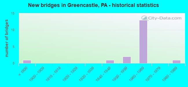
- New bridges - historical statistics
- 1Before 1900
- 11940-1949
- 21950-1959
- 131960-1969
- 11980-1989
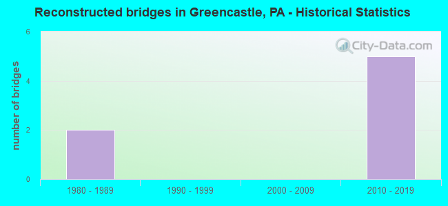
- Reconstructed bridges - Historical Statistics
- 21980-1989
- 01990-1999
- 02000-2009
- 52010-2019
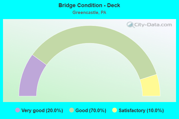
- Bridge Condition - Deck
- 20.0%Very good
- 70.0%Good
- 10.0%Satisfactory
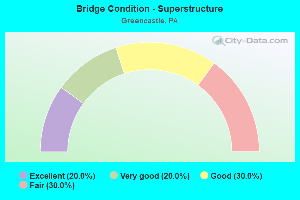
- Bridge Condition - Superstructure
- 20.0%Excellent
- 20.0%Very good
- 30.0%Good
- 30.0%Fair
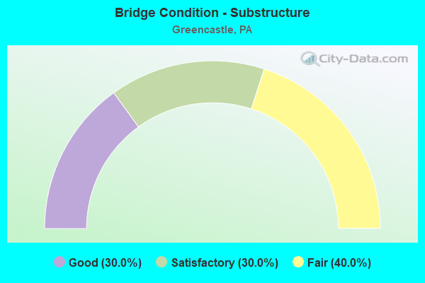
- Bridge Condition - Substructure
- 30.0%Good
- 30.0%Satisfactory
- 40.0%Fair
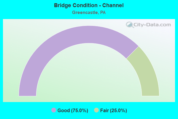
- Bridge Condition - Channel
- 75.0%Good
- 25.0%Fair
Find on map >> Show street view
Structure Number: 17299, Location: 1 mi. W. of Greencastle (Lat: 39.791758, Lng: -77.753986), Route carried "on" structure: State highway 16, Year Built: 1941, Year Reconstructed: 2018, Status: Open, Structure Length: 5.91m (19.39ft), Average Daily Traffic: 12,332 (year 2022), Truck Traffic: 13%, Average Future Daily Traffic: 16,565 (year 2032), Design Load: HL 93, Features Intersected: Conococheague Creek
Minimum Vertical Clearance: 30+ m (98+ ft), Kilometerpoint: 24.406, Lanes on structure: 2, Base Highway Network: Yes, Owner: State Highway Agency, Approaching Roadway Width: 11.6m (38.1ft), Skew: 4 degrees, Material/Design: Steel continuous, Design/Construction: Stringer/Multi-beam, Number Of Spans In Main Unit: 3, Length of Maximum Span: 19.5m (64.0ft), Curb-To-Curb Width: 12.2m (40.0ft), Out-to-Out Width: 12.8m (42.0ft)
Condition: Deck: Very good, Superstructure: Excellent, Substructure: Good, Channel: Good, Operating Rating: 50.2 metric tons, Method Used To Determine Operating Rating: Assigned ratings based on Load and Resistance Factor Design (LRFD) reported by rating factor (RF) using HL93 loadings, Inventory Rating: 38.2 metric tons, Method Used To Determine Inventory Rating: Assigned ratings based on Load and Resistance Factor Design (LRFD) reported by rating factor (RF) using HL93 loadings, Structural Evaluation: Better than present minimum criteria, Deck Geometry: Somewhat better than minimum adequacy, Waterway Adequacy: Superior to present desirable criteria, Approach Roadway Alignment: Equal to present desirable criteria, Length Of Structure Improvement: 6.90m (22.64ft), Designated Inspection Frequency: Every 24 months, Inspection Date: Febuary 2020, Bridge Improvement Cost: $79,000, Roadway Improvement Cost: $234,000, Total Project Cost: $1,071,000, Deck Structure Type: Concrete Cast-file-Place, Wearing Surface/Protective System: Wearing Surface: Monolithic Concrete, Deck Protection: Epoxy Coated Reinforcing
Find on map >> Show street view
Structure Number: 17362, Location: 0.5 ML. S.OF GREENCASTLE (Lat: 39.776472, Lng: -77.717142), Route carried "on" structure: Interstate 81, Year Built: 1963, Year Reconstructed: 2015, Status: Open, Structure Length: 3.23m (10.60ft), Average Daily Traffic: 22,617 (year 2021), Truck Traffic: 37%, Average Future Daily Traffic: 29,576 (year 2035), Design Load: HS 20, Features Intersected: SR 2002 LEITERSBURG RD
Minimum Vertical Clearance: 30+ m (98+ ft), Kilometerpoint: 6.441, Lanes on structure: 2, Lanes under structure: 2, Base Highway Network: Yes, Owner: State Highway Agency, Approaching Roadway Width: 12.2m (40.0ft), Skew: 12 degrees, Material/Design: Steel continuous, Design/Construction: Stringer/Multi-beam, Number Of Spans In Main Unit: 3, Length of Maximum Span: 12.2m (40.0ft), Curb or Sidewalk Widths: Left: 0.2m (0.7ft), Right: 0.2m (0.7ft), Curb-To-Curb Width: 12.9m (42.3ft), Out-to-Out Width: 13.9m (45.6ft)
Condition: Deck: Good, Superstructure: Very good, Substructure: Good, Operating Rating: 75.3 metric tons, Method Used To Determine Operating Rating: Load Factor (LF), Inventory Rating: 44.5 metric tons, Method Used To Determine Inventory Rating: Load Factor (LF), Structural Evaluation: Better than present minimum criteria, Deck Geometry: Superior to present desirable criteria, Underclear: Meets minimum limits, Approach Roadway Alignment: Equal to present desirable criteria, Length Of Structure Improvement: 4.20m (13.78ft), Designated Inspection Frequency: Every 24 months, Inspection Date: December 2019, Bridge Improvement Cost: $37,000, Roadway Improvement Cost: $110,000, Total Project Cost: $504,000, Deck Structure Type: Closed Grating, Wearing Surface/Protective System: Wearing Surface: Monolithic Concrete, Deck Protection: Galvanized Reinforcing
Find on map >> Show street view
Structure Number: 17363, Location: 0.5 ML. S. OF GREENCASTLE (Lat: 39.776642, Lng: -77.717392), Route carried "on" structure: Interstate 81, Year Built: 1963, Year Reconstructed: 2015, Status: Open, Structure Length: 3.29m (10.79ft), Average Daily Traffic: 22,927 (year 2021), Truck Traffic: 35%, Average Future Daily Traffic: 32,096 (year 2035), Design Load: HS 20, Features Intersected: SR 2002 LEITERSBURG ROAD
Minimum Vertical Clearance: 30+ m (98+ ft), Kilometerpoint: 6.434, Lanes on structure: 2, Lanes under structure: 2, Base Highway Network: Yes, Owner: State Highway Agency, Approaching Roadway Width: 12.2m (40.0ft), Skew: 12 degrees, Material/Design: Steel continuous, Design/Construction: Stringer/Multi-beam, Number Of Spans In Main Unit: 3, Length of Maximum Span: 12.2m (40.0ft), Curb or Sidewalk Widths: Left: 0.2m (0.7ft), Right: 0.2m (0.7ft), Curb-To-Curb Width: 12.9m (42.3ft), Out-to-Out Width: 13.9m (45.6ft)
Condition: Deck: Good, Superstructure: Very good, Substructure: Satisfactory, Operating Rating: 75.3 metric tons, Method Used To Determine Operating Rating: Load Factor (LF), Inventory Rating: 44.5 metric tons, Method Used To Determine Inventory Rating: Load Factor (LF), Structural Evaluation: Equal to present minimum criteria, Deck Geometry: Superior to present desirable criteria, Underclear: Equal to present minimum criteria, Approach Roadway Alignment: Equal to present desirable criteria, Length Of Structure Improvement: 4.20m (13.78ft), Designated Inspection Frequency: Every 24 months, Inspection Date: December 2019, Bridge Improvement Cost: $28,000, Roadway Improvement Cost: $82,000, Total Project Cost: $376,000, Deck Structure Type: Closed Grating, Wearing Surface/Protective System: Wearing Surface: Monolithic Concrete, Deck Protection: Galvanized Reinforcing
Find on map >> Show street view
Structure Number: 17364, Location: E.OF GREENCASTLE (Lat: 39.786542, Lng: -77.712983), Route carried "on" structure: Interstate 81, Year Built: 1963, Year Reconstructed: 1994, Status: Open, Structure Length: 4.24m (13.91ft), Average Daily Traffic: 23,181 (year 2021), Truck Traffic: 36%, Average Future Daily Traffic: 31,725 (year 2032), Design Load: HS 20, Features Intersected: PA 16; SR 0016
Minimum Vertical Clearance: 30+ m (98+ ft), Kilometerpoint: 7.253, Lanes on structure: 2, Lanes under structure: 8, Base Highway Network: Yes, Owner: State Highway Agency, Approaching Roadway Width: 11.6m (38.1ft), Skew: 10 degrees, Material/Design: Prestressed concrete, Design/Construction: Stringer/Multi-beam, Number Of Spans In Main Unit: 3, Length of Maximum Span: 21.3m (69.9ft), Curb or Sidewalk Widths: Left: 0.2m (0.7ft), Right: 0.2m (0.7ft), Curb-To-Curb Width: 12.2m (40.0ft), Out-to-Out Width: 13.3m (43.6ft)
Condition: Deck: Good, Superstructure: Good, Substructure: Fair, Operating Rating: 89.8 metric tons, Method Used To Determine Operating Rating: Load Factor (LF), Inventory Rating: 27.2 metric tons, Method Used To Determine Inventory Rating: Load Factor (LF), Structural Evaluation: Somewhat better than minimum adequacy, Deck Geometry: Better than present minimum criteria, Underclear: Meets minimum limits, Approach Roadway Alignment: Equal to present desirable criteria, Length Of Structure Improvement: 5.10m (16.73ft), Designated Inspection Frequency: Every 24 months, Inspection Date: Febuary 2020, Deck Structure Type: Concrete Cast-file-Place, Wearing Surface/Protective System: Wearing Surface: Monolithic Concrete, Deck Protection: Epoxy Coated Reinforcing
Find on map >> Show street view
Structure Number: 17365, Location: E. OF GREENCASTLE (Lat: 39.786600, Lng: -77.713275), Route carried "on" structure: Interstate 81, Year Built: 1963, Year Reconstructed: 1994, Status: Open, Structure Length: 4.24m (13.91ft), Average Daily Traffic: 23,500 (year 2021), Truck Traffic: 34%, Average Future Daily Traffic: 32,683 (year 2032), Design Load: HS 20, Features Intersected: PA 16; SR 0016
Minimum Vertical Clearance: 30+ m (98+ ft), Kilometerpoint: 7.265, Lanes on structure: 2, Lanes under structure: 8, Base Highway Network: Yes, Owner: State Highway Agency, Approaching Roadway Width: 11.6m (38.1ft), Skew: 10 degrees, Material/Design: Prestressed concrete, Design/Construction: Stringer/Multi-beam, Number Of Spans In Main Unit: 3, Length of Maximum Span: 21.3m (69.9ft), Curb or Sidewalk Widths: Left: 0.2m (0.7ft), Right: 0.2m (0.7ft), Curb-To-Curb Width: 12.2m (40.0ft), Out-to-Out Width: 13.3m (43.6ft)
Condition: Deck: Good, Superstructure: Fair, Substructure: Fair, Operating Rating: 65.3 metric tons, Method Used To Determine Operating Rating: Load Factor (LF), Inventory Rating: 27.2 metric tons, Method Used To Determine Inventory Rating: Load Factor (LF), Structural Evaluation: Somewhat better than minimum adequacy, Deck Geometry: Better than present minimum criteria, Underclear: Meets minimum limits, Approach Roadway Alignment: Equal to present desirable criteria, Length Of Structure Improvement: 5.10m (16.73ft), Designated Inspection Frequency: Every 24 months, Inspection Date: Febuary 2020, Deck Structure Type: Concrete Cast-file-Place, Wearing Surface/Protective System: Wearing Surface: Monolithic Concrete, Deck Protection: Epoxy Coated Reinforcing
Find on map >> Show street view
Structure Number: 17369, Location: 2.5 MI.N.OF GREENCASTLE (Lat: 39.816667, Lng: -77.703331), Route carried "on" structure: State highway , Year Built: 1963, Status: Open, Structure Length: 6.74m (22.11ft), Average Daily Traffic: 534 (year 2020), Truck Traffic: 8%, Average Future Daily Traffic: 619 (year 2032), Design Load: HS 20, Features Intersected: I-81; SR 0081, Facility Carried by Structure: T-437; ZARGER RD
Minimum Vertical Clearance: 30+ m (98+ ft), Kilometerpoint: 0.000, Lanes on structure: 2, Lanes under structure: 8, Owner: State Highway Agency, Approaching Roadway Width: 8.5m (27.9ft), Skew: 2 degrees, Material/Design: Prestressed concrete, Design/Construction: Box Beam or Girders - Multiple, Number Of Spans In Main Unit: 4, Length of Maximum Span: 21.9m (71.9ft), Curb or Sidewalk Widths: Left: 0.5m (1.6ft), Right: 0.5m (1.6ft), Curb-To-Curb Width: 8.6m (28.2ft), Out-to-Out Width: 10.2m (33.5ft)
Condition: Deck: Good, Superstructure: Good, Substructure: Fair, Operating Rating: 62.6 metric tons, Method Used To Determine Operating Rating: Load Factor (LF), Inventory Rating: 27.2 metric tons, Method Used To Determine Inventory Rating: Load Factor (LF), Structural Evaluation: Somewhat better than minimum adequacy, Deck Geometry: Somewhat better than minimum adequacy, Underclear: Superior to present desirable criteria, Approach Roadway Alignment: Better than present minimum criteria, Length Of Structure Improvement: 7.70m (25.26ft), Designated Inspection Frequency: Every 24 months, Inspection Date: Febuary 2020, Bridge Improvement Cost: $41,000, Roadway Improvement Cost: $120,000, Total Project Cost: $550,000, Deck Structure Type: Concrete Cast-file-Place, Wearing Surface/Protective System: Wearing Surface: Latex Concrete
Find on map >> Show street view
Structure Number: 17538, Location: 1.5MI.NW OF GREENCASTLE (Lat: 39.809444, Lng: -77.736867), Route carried "on" structure: State highway , Year Built: 1957, Year Reconstructed: 2017, Status: Open, Structure Length: 3.84m (12.60ft), Average Daily Traffic: 3,151 (year 2022), Truck Traffic: 3%, Average Future Daily Traffic: 4,711 (year 2035), Design Load: HL 93, Features Intersected: MUDDY RUN, Facility Carried by Structure: SR 3002 willamson
Minimum Vertical Clearance: 30+ m (98+ ft), Kilometerpoint: 13.330, Lanes on structure: 2, Owner: State Highway Agency, Approaching Roadway Width: 7.3m (24.0ft), Material/Design: Steel continuous, Design/Construction: Stringer/Multi-beam, Number Of Spans In Main Unit: 3, Length of Maximum Span: 17.4m (57.1ft), Curb-To-Curb Width: 8.5m (27.9ft), Out-to-Out Width: 9.4m (30.8ft)
Condition: Deck: Very good, Superstructure: Excellent, Substructure: Satisfactory, Channel: Good, Operating Rating: 80.7 metric tons, Method Used To Determine Operating Rating: Load and Resistance Factor (LRFR), Inventory Rating: 63.5 metric tons, Method Used To Determine Inventory Rating: Load and Resistance Factor (LRFR), Structural Evaluation: Equal to present minimum criteria, Deck Geometry: Meets minimum limits, Waterway Adequacy: Superior to present desirable criteria, Approach Roadway Alignment: Equal to present desirable criteria, Length Of Structure Improvement: 3.80m (12.47ft), Designated Inspection Frequency: Every 24 months, Inspection Date: December 2019, Bridge Improvement Cost: $24,000, Roadway Improvement Cost: $70,000, Total Project Cost: $321,000, Deck Structure Type: Concrete Cast-file-Place, Wearing Surface/Protective System: Wearing Surface: Monolithic Concrete, Deck Protection: Epoxy Coated Reinforcing
Find on map >> Show street view
Structure Number: 17631, Location: 1.5NE UPTON/CONOCOCHEAGUE (Lat: 39.817894, Lng: -77.788278), Route carried "on" structure: City street , Year Built: 1959, Status: Open, Structure Length: 4.27m (14.01ft), Average Daily Traffic: 400 (year 2009), Average Future Daily Traffic: 560 (year 2029), Design Load: HS 20, Features Intersected: CONCOCHEAGUE CREEK, Facility Carried by Structure: KUHN RD
Minimum Vertical Clearance: 30+ m (98+ ft), Kilometerpoint: 0.000, Lanes on structure: 1, Owner: County Highway Agency, Approaching Roadway Width: 6.1m (20.0ft), Material/Design: Prestressed concrete, Design/Construction: Stringer/Multi-beam, Number Of Spans In Main Unit: 3, Length of Maximum Span: 14.0m (45.9ft), Curb-To-Curb Width: 4.8m (15.7ft), Out-to-Out Width: 5.5m (18.0ft)
Condition: Deck: Satisfactory, Superstructure: Fair, Substructure: Fair, Channel: Fair, Operating Rating: 58.1 metric tons, Method Used To Determine Operating Rating: Load Factor (LF), Inventory Rating: 34.5 metric tons, Method Used To Determine Inventory Rating: Load Factor (LF), Structural Evaluation: Somewhat better than minimum adequacy, Deck Geometry: High priority of corrective action, Waterway Adequacy: Superior to present desirable criteria, Approach Roadway Alignment: Somewhat better than minimum adequacy, Length Of Structure Improvement: 5.20m (17.06ft), Designated Inspection Frequency: Every 24 months, Inspection Date: December 2019, Bridge Improvement Cost: $15,000, Roadway Improvement Cost: $43,000, Total Project Cost: $198,000, Deck Structure Type: Concrete Precast Panels, Wearing Surface/Protective System: Wearing Surface: Bituminous, Membrane: Preformed Fabric
Find on map >> Show street view
Structure Number: 1776, Location: GREENCASTLE/NSRC (Lat: 39.797083, Lng: -77.726119), Route carried "on" structure: City street , Year Built: 1988, Status: Open, Structure Length: 3.81m (12.50ft), Average Daily Traffic: 2,800 (year 1990), Average Future Daily Traffic: 3,920 (year 2010), Design Load: HS 25 or greater, Features Intersected: NORFOLK SOUTHERN RAILWAY, Facility Carried by Structure: WALTER AVENUE
Minimum Vertical Clearance: 30+ m (98+ ft), Kilometerpoint: 0.000, Lanes on structure: 2, Owner: City or Municipal Highway Agency, Maintenance Responsibility: County Highway Agency, Approaching Roadway Width: 9.1m (29.9ft), Material/Design: Prestressed concrete, Design/Construction: Box Beam or Girders - Multiple, Number Of Spans In Main Unit: 3, Length of Maximum Span: 12.8m (42.0ft), Curb or Sidewalk Widths: Left: 0.2m (0.7ft), Right: 1.2m (3.9ft), Curb-To-Curb Width: 8.9m (29.2ft), Out-to-Out Width: 11.1m (36.4ft)
Condition: Deck: Good, Superstructure: Fair, Substructure: Satisfactory, Operating Rating: 94.3 metric tons, Method Used To Determine Operating Rating: Load Factor (LF), Inventory Rating: 48.1 metric tons, Method Used To Determine Inventory Rating: Load Factor (LF), Structural Evaluation: Somewhat better than minimum adequacy, Deck Geometry: Meets minimum limits, Underclear: High priority of replacement, Approach Roadway Alignment: Somewhat better than minimum adequacy, Length Of Structure Improvement: 4.80m (15.75ft), Designated Inspection Frequency: Every 24 months, Inspection Date: June 2020, Bridge Improvement Cost: $29,000, Roadway Improvement Cost: $86,000, Total Project Cost: $340,000, Deck Structure Type: Concrete Cast-file-Place, Wearing Surface/Protective System: Wearing Surface: Monolithic Concrete, Deck Protection: Epoxy Coated Reinforcing
Find on map >> Show street view
Structure Number: 5329, Location: 4.5 MI SW of Greencastle (Lat: 39.764897, Lng: -77.775697), Route carried "on" structure: City street , Year Built: 1849, Year Reconstructed: 2015, Status: Posted for load, Structure Length: 6.34m (20.80ft), Average Daily Traffic: 5 (year 2016), Average Future Daily Traffic: 5 (year 2025), Design Load: HS 15, Features Intersected: Conococheague Creek, Facility Carried by Structure: Weaver Road, T-341
Minimum Vertical Clearance: 2.84m (9.32ft), Kilometerpoint: 0.000, Lanes on structure: 1, Owner: Town or Township Highway Agency, Approaching Roadway Width: 4.6m (15.1ft), Material/Design: Steel continuous, Design/Construction: Stringer/Multi-beam, Number Of Spans In Main Unit: 2, Length of Maximum Span: 30.8m (101.0ft), Curb-To-Curb Width: 4.5m (14.8ft), Out-to-Out Width: 5.2m (17.1ft)
Condition: Deck: Good, Superstructure: Good, Substructure: Good, Channel: Good, Operating Rating: 10.9 metric tons, Method Used To Determine Operating Rating: Load and Resistance Factor (LRFR), Inventory Rating: 8.2 metric tons, Method Used To Determine Inventory Rating: Load and Resistance Factor (LRFR), Structural Evaluation: High priority of corrective action, Deck Geometry: High priority of corrective action, Waterway Adequacy: Equal to present desirable criteria, Approach Roadway Alignment: Meets minimum limits, Bridge Posting: Required (Relationship of Operating Rating to Maximum Legal Load: > 39.9% below), Designated Inspection Frequency: Every 24 months, Other Special Inspection Frequency: Every 12 months, Inspection Date: June 2020, Other Special Inspection Date: June 2021, Deck Structure Type: Wood or Timber, Wearing Surface/Protective System: Wearing Surface: Wood or Timber
Find on map >> Show street view
Structure Number: 17362, Location: 0.5 ML. S.OF GREENCASTLE (Lat: 39.776472, Lng: -77.717142), Route carried "under" structure: State highway , Year Built: 1963, Structure Length: 0. m, Average Daily Traffic: 1,299 (year 2020), Truck Traffic: 6%, Features Intersected: SR 2002 LEITERSBURG RD, Facility Carried by Structure: I-81 NB; SR 0081
Minimum Vertical Clearance: 4.44m (14.57ft), Kilometerpoint: 0.858, Lanes on structure: 2, Lanes under structure: 2, Material/Design: Steel continuous, Design/Construction: Stringer/Multi-beam, Length of Maximum Span: 12.2m (40.0ft)
Find on map >> Show street view
Structure Number: 17363, Location: 0.5 ML. S. OF GREENCASTLE (Lat: 39.776642, Lng: -77.717392), Route carried "under" structure: State highway , Year Built: 1963, Structure Length: 0. m, Average Daily Traffic: 1,299 (year 2020), Truck Traffic: 6%, Features Intersected: SR 2002 LEITERSBURG ROAD, Facility Carried by Structure: I-81 SB; SR 0081
Minimum Vertical Clearance: 4.65m (15.26ft), Kilometerpoint: 0.858, Lanes on structure: 2, Lanes under structure: 2, Material/Design: Steel continuous, Design/Construction: Stringer/Multi-beam, Length of Maximum Span: 12.2m (40.0ft)
Find on map >> Show street view
Structure Number: 17364, Location: E.OF GREENCASTLE (Lat: 39.786542, Lng: -77.712983), Route carried "under" structure: State highway 16, Year Built: 1963, Structure Length: 0. m, Average Daily Traffic: 5,833 (year 2020), Truck Traffic: 7%, Features Intersected: PA 16; SR 0016, Facility Carried by Structure: I-81 NB; SR 0081
Minimum Vertical Clearance: 4.65m (15.26ft), Kilometerpoint: 28.629, Lanes on structure: 2, Lanes under structure: 4, Material/Design: Prestressed concrete, Design/Construction: Stringer/Multi-beam, Length of Maximum Span: 21.3m (69.9ft)
Find on map >> Show street view
Structure Number: 17364, Location: E.OF GREENCASTLE (Lat: 39.786542, Lng: -77.712983), Route carried "under" structure: State highway 16, Year Built: 1963, Structure Length: 0. m, Average Daily Traffic: 5,833 (year 2020), Truck Traffic: 7%, Features Intersected: PA 16; SR 0016, Facility Carried by Structure: I-81 NB; SR 0081
Minimum Vertical Clearance: 4.85m (15.91ft), Kilometerpoint: 28.629, Lanes on structure: 2, Lanes under structure: 4, Material/Design: Prestressed concrete, Design/Construction: Stringer/Multi-beam, Length of Maximum Span: 21.3m (69.9ft)
Find on map >> Show street view
Structure Number: 17365, Location: E. OF GREENCASTLE (Lat: 39.786600, Lng: -77.713275), Route carried "under" structure: State highway 16, Year Built: 1963, Structure Length: 0. m, Average Daily Traffic: 5,833 (year 2020), Truck Traffic: 7%, Features Intersected: PA 16; SR 0016, Facility Carried by Structure: I-81 SB; SR 0081
Minimum Vertical Clearance: 4.48m (14.70ft), Kilometerpoint: 28.629, Lanes on structure: 2, Lanes under structure: 4, Material/Design: Prestressed concrete, Design/Construction: Stringer/Multi-beam, Length of Maximum Span: 21.3m (69.9ft)
Find on map >> Show street view
Structure Number: 17365, Location: E. OF GREENCASTLE (Lat: 39.786600, Lng: -77.713275), Route carried "under" structure: State highway 16, Year Built: 1963, Structure Length: 0. m, Average Daily Traffic: 5,833 (year 2020), Truck Traffic: 7%, Features Intersected: PA 16; SR 0016, Facility Carried by Structure: I-81 SB; SR 0081
Minimum Vertical Clearance: 4.67m (15.32ft), Kilometerpoint: 28.629, Lanes on structure: 2, Lanes under structure: 4, Material/Design: Prestressed concrete, Design/Construction: Stringer/Multi-beam, Length of Maximum Span: 21.3m (69.9ft)
Find on map >> Show street view
Structure Number: 17369, Location: 2.5 MI.N.OF GREENCASTLE (Lat: 39.816667, Lng: -77.703331), Route carried "under" structure: Interstate 81, Year Built: 1963, Structure Length: 0. m, Average Daily Traffic: 23,181 (year 2021), Truck Traffic: 36%, Features Intersected: I-81; SR 0081, Facility Carried by Structure: T-437; ZARGER RD
Minimum Vertical Clearance: 5.26m (17.26ft), Kilometerpoint: 10.470, Lanes on structure: 2, Lanes under structure: 4, Material/Design: Prestressed concrete, Design/Construction: Box Beam or Girders - Multiple, Length of Maximum Span: 21.9m (71.9ft)
Find on map >> Show street view
Structure Number: 17369, Location: 2.5 MI.N.OF GREENCASTLE (Lat: 39.816667, Lng: -77.703331), Route carried "under" structure: Interstate 81, Year Built: 1963, Structure Length: 0. m, Average Daily Traffic: 23,500 (year 2021), Truck Traffic: 34%, Features Intersected: I-81; SR 0081, Facility Carried by Structure: T-437; ZARGER RD
Minimum Vertical Clearance: 5.26m (17.26ft), Kilometerpoint: 10.454, Lanes on structure: 2, Lanes under structure: 4, Material/Design: Prestressed concrete, Design/Construction: Box Beam or Girders - Multiple, Length of Maximum Span: 21.9m (71.9ft)