Bridge Statistics for Green River, Wyoming (WY)
Condition, Traffic, Stress, Structural Evaluation, Project Costs
- National Bridge Inventory (NBI) Statistics
- 26Number of bridges
- 499ft / 152mTotal length
- $3,000Total costs
- 149,496Total average daily traffic
- 47,940Total average daily truck traffic
- National Bridge Inventory (NBI) Registered Bridges for Green River
- No street view available for this location
- New bridges - historical statistics
- 11930-1939
- 11950-1959
- 41960-1969
- 21970-1979
- 11980-1989
- 81990-1999
- 72000-2009
- 22010-2019
- Bridge Condition - Deck
- 6.7%Very good
- 46.7%Good
- 33.3%Satisfactory
- 6.7%Fair
- 6.7%Poor
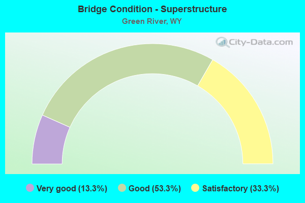
- Bridge Condition - Superstructure
- 13.3%Very good
- 53.3%Good
- 33.3%Satisfactory
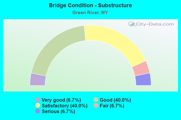
- Bridge Condition - Substructure
- 6.7%Very good
- 40.0%Good
- 40.0%Satisfactory
- 6.7%Fair
- 6.7%Serious
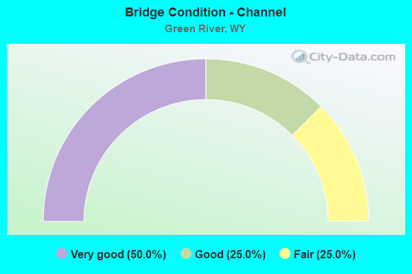
- Bridge Condition - Channel
- 50.0%Very good
- 25.0%Good
- 25.0%Fair
Find on map >> Show street view
Structure Number: APG, Location: Green River (Lat: 41.538989, Lng: -109.474778), Route carried "on" structure: Interstate 80, Year Built: 1966, Status: Open, Structure Length: 3.14m (10.30ft), Average Daily Traffic: 8,462 (year 2021), Truck Traffic: 93%, Average Future Daily Traffic: 11,847 (year 2041), Design Load: HS 20+Mod, Features Intersected: Sw CR 53 / White Mtn Rd
Minimum Vertical Clearance: 30+ m (98+ ft), Kilometerpoint: 144.363, Lanes on structure: 2, Lanes under structure: 2, Base Highway Network: Yes (Inventory Route: ML8, Subroute: 1), Owner: State Highway Agency, Approaching Roadway Width: 11.6m (38.1ft), Skew: 12 degrees, Material/Design: Steel continuous, Design/Construction: Stringer/Multi-beam, Number Of Spans In Main Unit: 3, Length of Maximum Span: 11.7m (38.4ft), Curb-To-Curb Width: 11.6m (38.1ft), Out-to-Out Width: 12.3m (40.4ft)
Condition: Deck: Fair, Superstructure: Satisfactory, Substructure: Satisfactory, Operating Rating: 51.3 metric tons, Method Used To Determine Operating Rating: Load Factor (LF), Inventory Rating: 30.6 metric tons, Method Used To Determine Inventory Rating: Load Factor (LF), Structural Evaluation: Equal to present minimum criteria, Deck Geometry: Equal to present minimum criteria, Underclear: Meets minimum limits, Approach Roadway Alignment: Equal to present desirable criteria, Designated Inspection Frequency: Every 24 months, Inspection Date: June 2021, Deck Structure Type: Concrete Cast-file-Place, Wearing Surface/Protective System: Wearing Surface: Latex Concrete
Find on map >> Show street view
Structure Number: APH, Location: Green River (Lat: 41.539117, Lng: -109.474589), Route carried "on" structure: Interstate 80, Year Built: 1966, Status: Open, Structure Length: 3.14m (10.30ft), Average Daily Traffic: 9,555 (year 2021), Truck Traffic: 44%, Average Future Daily Traffic: 13,377 (year 2041), Design Load: HS 20+Mod, Features Intersected: Sw CR 53 / White Mtn Rd
Minimum Vertical Clearance: 30+ m (98+ ft), Kilometerpoint: 144.175, Lanes on structure: 2, Lanes under structure: 2, Base Highway Network: Yes (Inventory Route: ML8, Subroute: 1), Owner: State Highway Agency, Approaching Roadway Width: 11.6m (38.1ft), Skew: 12 degrees, Material/Design: Steel continuous, Design/Construction: Stringer/Multi-beam, Number Of Spans In Main Unit: 3, Length of Maximum Span: 11.7m (38.4ft), Curb-To-Curb Width: 11.6m (38.1ft), Out-to-Out Width: 12.3m (40.4ft)
Condition: Deck: Satisfactory, Superstructure: Satisfactory, Substructure: Satisfactory, Operating Rating: 51.3 metric tons, Method Used To Determine Operating Rating: Load Factor (LF), Inventory Rating: 30.6 metric tons, Method Used To Determine Inventory Rating: Load Factor (LF), Structural Evaluation: Equal to present minimum criteria, Deck Geometry: Equal to present minimum criteria, Underclear: Meets minimum limits, Approach Roadway Alignment: Equal to present desirable criteria, Designated Inspection Frequency: Every 24 months, Inspection Date: June 2021, Deck Structure Type: Concrete Cast-file-Place, Wearing Surface/Protective System: Wearing Surface: Latex Concrete
Find on map >> Show street view
Structure Number: APK, Location: Green River (Lat: 41.531347, Lng: -109.459414), Route carried "on" structure: Interstate 80, Year Built: 1966, Status: Open, Structure Length: 3.09m (10.14ft), Average Daily Traffic: 8,462 (year 2021), Truck Traffic: 93%, Average Future Daily Traffic: 11,847 (year 2041), Design Load: HS 20+Mod, Features Intersected: Riverview Cemetery Road
Minimum Vertical Clearance: 30+ m (98+ ft), Kilometerpoint: 145.908, Lanes on structure: 2, Lanes under structure: 2, Base Highway Network: Yes (Inventory Route: ML8, Subroute: 1), Owner: State Highway Agency, Approaching Roadway Width: 11.6m (38.1ft), Skew: 10 degrees, Material/Design: Steel continuous, Design/Construction: Stringer/Multi-beam, Number Of Spans In Main Unit: 3, Length of Maximum Span: 11.6m (38.1ft), Curb-To-Curb Width: 11.6m (38.1ft), Out-to-Out Width: 12.3m (40.4ft)
Condition: Deck: Satisfactory, Superstructure: Good, Substructure: Good, Operating Rating: 53.1 metric tons, Method Used To Determine Operating Rating: Load Factor (LF), Inventory Rating: 31.5 metric tons, Method Used To Determine Inventory Rating: Load Factor (LF), Structural Evaluation: Better than present minimum criteria, Deck Geometry: Equal to present minimum criteria, Underclear: Meets minimum limits, Approach Roadway Alignment: Equal to present desirable criteria, Designated Inspection Frequency: Every 24 months, Inspection Date: June 2021, Deck Structure Type: Concrete Cast-file-Place, Wearing Surface/Protective System: Wearing Surface: Epoxy Overlay
Find on map >> Show street view
Structure Number: APL, Location: Green River (Lat: 41.531536, Lng: -109.459242), Route carried "on" structure: Interstate 80, Year Built: 1966, Status: Open, Structure Length: 3.09m (10.14ft), Average Daily Traffic: 9,555 (year 2021), Truck Traffic: 44%, Average Future Daily Traffic: 13,377 (year 2041), Design Load: HS 20+Mod, Features Intersected: Riverview Cemetery Road
Minimum Vertical Clearance: 30+ m (98+ ft), Kilometerpoint: 145.715, Lanes on structure: 2, Lanes under structure: 2, Base Highway Network: Yes (Inventory Route: ML8, Subroute: 1), Owner: State Highway Agency, Approaching Roadway Width: 11.6m (38.1ft), Skew: 10 degrees, Material/Design: Steel continuous, Design/Construction: Stringer/Multi-beam, Number Of Spans In Main Unit: 3, Length of Maximum Span: 11.6m (38.1ft), Curb-To-Curb Width: 11.6m (38.1ft), Out-to-Out Width: 12.3m (40.4ft)
Condition: Deck: Good, Superstructure: Good, Substructure: Good, Operating Rating: 53.1 metric tons, Method Used To Determine Operating Rating: Load Factor (LF), Inventory Rating: 31.5 metric tons, Method Used To Determine Inventory Rating: Load Factor (LF), Structural Evaluation: Better than present minimum criteria, Deck Geometry: Equal to present minimum criteria, Underclear: Meets minimum limits, Approach Roadway Alignment: Equal to present desirable criteria, Designated Inspection Frequency: Every 24 months, Inspection Date: June 2021, Deck Structure Type: Concrete Cast-file-Place, Wearing Surface/Protective System: Wearing Surface: Epoxy Overlay
Find on map >> Show street view
Structure Number: CVL, Location: Green River (Lat: 41.519542, Lng: -109.465686), Route carried "on" structure: State highway 530, Year Built: 1953, Status: Open, Structure Length: 13.93m (45.70ft), Average Daily Traffic: 10,258 (year 2021), Truck Traffic: 4%, Average Future Daily Traffic: 14,361 (year 2041), Design Load: H 20, Features Intersected: Green River
Minimum Vertical Clearance: 30+ m (98+ ft), Kilometerpoint: 1.226, Lanes on structure: 2, Base Highway Network: Yes (Inventory Route: ML190, Subroute: 1), Owner: State Highway Agency, Approaching Roadway Width: 9.8m (32.2ft), Material/Design: Steel continuous, Design/Construction: Stringer/Multi-beam, Number Of Spans In Main Unit: 4, Length of Maximum Span: 37.8m (124.0ft), Curb or Sidewalk Widths: Left: 1.2m (3.9ft), Right: 1.2m (3.9ft), Curb-To-Curb Width: 9.1m (29.9ft), Out-to-Out Width: 13.0m (42.7ft)
Condition: Deck: Satisfactory, Superstructure: Satisfactory, Substructure: Fair, Channel: Good, Operating Rating: 70.8 metric tons, Method Used To Determine Operating Rating: Load Factor (LF), Inventory Rating: 41.7 metric tons, Method Used To Determine Inventory Rating: Load Factor (LF), Structural Evaluation: Somewhat better than minimum adequacy, Deck Geometry: Meets minimum limits, Waterway Adequacy: Equal to present desirable criteria, Approach Roadway Alignment: Equal to present desirable criteria, Designated Inspection Frequency: Every 24 months, Underwater Inspection Frequency: Every 60 months, Inspection Date: June 2021, Underwater Inspection Date: August 2019, Deck Structure Type: Concrete Cast-file-Place, Wearing Surface/Protective System: Wearing Surface: Latex Concrete
Find on map >> Show street view
Structure Number: DDH, Location: Green River (Lat: 41.525214, Lng: -109.459964), Route carried "on" structure: State highway 530, Year Built: 1978, Status: Open, Structure Length: 35.74m (117.26ft), Average Daily Traffic: 10,258 (year 2021), Truck Traffic: 4%, Average Future Daily Traffic: 14,361 (year 2041), Design Load: HS 20, Features Intersected: UPRR / I-80 Bus
Minimum Vertical Clearance: 30+ m (98+ ft), Kilometerpoint: 0.425, Lanes on structure: 2, Lanes under structure: 3, Base Highway Network: Yes, Owner: State Highway Agency, Approaching Roadway Width: 9.8m (32.2ft), Skew: 20 degrees, Material/Design: Steel continuous, Design/Construction: Stringer/Multi-beam, Number Of Spans In Main Unit: 7, Length of Maximum Span: 67.4m (221.1ft), Curb or Sidewalk Widths: Left: 0.6m (2.0ft), Right: 1.8m (5.9ft), Curb-To-Curb Width: 9.8m (32.2ft), Out-to-Out Width: 12.5m (41.0ft)
Condition: Deck: Satisfactory, Superstructure: Good, Substructure: Serious, Operating Rating: 80.3 metric tons, Method Used To Determine Operating Rating: Load Factor (LF), Inventory Rating: 48.1 metric tons, Method Used To Determine Inventory Rating: Load Factor (LF), Structural Evaluation: High priority of corrective action, Deck Geometry: Meets minimum limits, Underclear: High priority of corrective action, Approach Roadway Alignment: Equal to present desirable criteria, Designated Inspection Frequency: Every 24 months, Inspection Date: June 2021, Deck Structure Type: Concrete Cast-file-Place, Wearing Surface/Protective System: Deck Protection: Epoxy Coated Reinforcing
Find on map >> Show street view
Structure Number: DNJ, Location: Green River (Lat: 41.519650, Lng: -109.465792), Route carried "on" structure: State highway 530, Year Built: 1982, Status: Open, Structure Length: 13.98m (45.87ft), Average Daily Traffic: 10,258 (year 2021), Truck Traffic: 4%, Average Future Daily Traffic: 14,361 (year 2041), Design Load: HS 20, Features Intersected: Green River
Minimum Vertical Clearance: 30+ m (98+ ft), Kilometerpoint: 1.221, Lanes on structure: 2, Base Highway Network: Yes (Inventory Route: ML190, Subroute: 1), Owner: State Highway Agency, Approaching Roadway Width: 9.8m (32.2ft), Material/Design: Steel continuous, Design/Construction: Stringer/Multi-beam, Number Of Spans In Main Unit: 4, Length of Maximum Span: 37.8m (124.0ft), Curb or Sidewalk Widths: Left: 0.0m, Right: 1.7m (5.6ft), Curb-To-Curb Width: 9.8m (32.2ft), Out-to-Out Width: 12.3m (40.4ft)
Condition: Deck: Poor, Superstructure: Satisfactory, Substructure: Good, Channel: Very good, Operating Rating: 65.3 metric tons, Method Used To Determine Operating Rating: Load Factor (LF), Inventory Rating: 39.0 metric tons, Method Used To Determine Inventory Rating: Load Factor (LF), Structural Evaluation: Equal to present minimum criteria, Deck Geometry: Meets minimum limits, Waterway Adequacy: Equal to present desirable criteria, Approach Roadway Alignment: Equal to present desirable criteria, Designated Inspection Frequency: Every 24 months, Underwater Inspection Frequency: Every 60 months, Inspection Date: June 2021, Underwater Inspection Date: August 2019, Deck Structure Type: Concrete Cast-file-Place, Wearing Surface/Protective System: Wearing Surface: Latex Concrete
Find on map >> Show street view
Structure Number: JQL, Location: Green River (Lat: 41.525172, Lng: -109.459867), Route carried "on" structure: State highway 530, Year Built: 1994, Status: Open, Structure Length: 35.74m (117.26ft), Average Daily Traffic: 10,258 (year 2021), Truck Traffic: 4%, Average Future Daily Traffic: 14,361 (year 2041), Design Load: HS 20, Features Intersected: UPRR / US 30
Minimum Vertical Clearance: 30+ m (98+ ft), Kilometerpoint: 0.423, Lanes on structure: 2, Lanes under structure: 3, Base Highway Network: Yes, Owner: State Highway Agency, Approaching Roadway Width: 9.8m (32.2ft), Material/Design: Steel continuous, Design/Construction: Stringer/Multi-beam, Number Of Spans In Main Unit: 7, Length of Maximum Span: 67.4m (221.1ft), Curb or Sidewalk Widths: Left: 0.0m, Right: 1.0m (3.3ft), Curb-To-Curb Width: 9.8m (32.2ft), Out-to-Out Width: 11.0m (36.1ft)
Condition: Deck: Satisfactory, Superstructure: Satisfactory, Substructure: Satisfactory, Operating Rating: 72.6 metric tons, Method Used To Determine Operating Rating: Load Factor (LF), Inventory Rating: 43.5 metric tons, Method Used To Determine Inventory Rating: Load Factor (LF), Structural Evaluation: Equal to present minimum criteria, Deck Geometry: Meets minimum limits, Underclear: Somewhat better than minimum adequacy, Approach Roadway Alignment: Equal to present desirable criteria, Designated Inspection Frequency: Every 24 months, Inspection Date: June 2021, Deck Structure Type: Concrete Cast-file-Place
Find on map >> Show street view
Structure Number: KED, Location: Green River Marginal (Lat: 41.541256, Lng: -109.478714), Route carried "on" structure: Interstate 80, Year Built: 1995, Status: Open, Structure Length: 6.10m (20.01ft), Average Daily Traffic: 8,350 (year 2021), Truck Traffic: 45%, Average Future Daily Traffic: 11,690 (year 2041), Design Load: HS 25 or greater, Features Intersected: West Green River Intg
Minimum Vertical Clearance: 6.72m (22.05ft), Kilometerpoint: 143.945, Lanes on structure: 2, Lanes under structure: 2, Base Highway Network: Yes (Inventory Route: ML8, Subroute: 1), Owner: State Highway Agency, Approaching Roadway Width: 12.2m (40.0ft), Skew: 1 degrees, Material/Design: Steel, Design/Construction: Stringer/Multi-beam, Number Of Spans In Main Unit: 3, Length of Maximum Span: 24.4m (80.1ft), Curb-To-Curb Width: 12.2m (40.0ft), Out-to-Out Width: 13.0m (42.7ft)
Condition: Deck: Good, Superstructure: Good, Substructure: Satisfactory, Operating Rating: 89.1 metric tons, Method Used To Determine Operating Rating: Load Factor (LF), Inventory Rating: 42.3 metric tons, Method Used To Determine Inventory Rating: Load Factor (LF), Structural Evaluation: Equal to present minimum criteria, Deck Geometry: Somewhat better than minimum adequacy, Underclear: Meets minimum limits, Approach Roadway Alignment: Equal to present desirable criteria, Designated Inspection Frequency: Every 24 months, Inspection Date: June 2021, Deck Structure Type: Concrete Cast-file-Place, Wearing Surface/Protective System: Wearing Surface: Epoxy Overlay
Find on map >> Show street view
Structure Number: KEE, Location: Green River Marginal (Lat: 41.541442, Lng: -109.478564), Route carried "on" structure: Interstate 80, Year Built: 1995, Status: Open, Structure Length: 6.10m (20.01ft), Average Daily Traffic: 8,662 (year 2021), Truck Traffic: 44%, Average Future Daily Traffic: 12,127 (year 2041), Design Load: HS 25 or greater, Features Intersected: West Green River Intg
Minimum Vertical Clearance: 5.04m (16.54ft), Kilometerpoint: 143.750, Lanes on structure: 3, Lanes under structure: 2, Base Highway Network: Yes (Inventory Route: ML8, Subroute: 1), Owner: State Highway Agency, Approaching Roadway Width: 14.6m (47.9ft), Skew: 1 degrees, Material/Design: Steel, Design/Construction: Stringer/Multi-beam, Number Of Spans In Main Unit: 3, Length of Maximum Span: 24.4m (80.1ft), Curb-To-Curb Width: 14.6m (47.9ft), Out-to-Out Width: 15.5m (50.9ft)
Condition: Deck: Good, Superstructure: Good, Substructure: Satisfactory, Operating Rating: 89.1 metric tons, Method Used To Determine Operating Rating: Load Factor (LF), Inventory Rating: 43.2 metric tons, Method Used To Determine Inventory Rating: Load Factor (LF), Structural Evaluation: Equal to present minimum criteria, Deck Geometry: Meets minimum limits, Underclear: High priority of corrective action, Approach Roadway Alignment: Equal to present desirable criteria, Designated Inspection Frequency: Every 24 months, Inspection Date: June 2021, Deck Structure Type: Concrete Cast-file-Place, Wearing Surface/Protective System: Wearing Surface: Epoxy Overlay
Find on map >> Show street view
Structure Number: LEU, Location: Green River (Lat: 41.523786, Lng: -109.446147), Route carried "on" structure: Interstate 80, Year Built: 2002, Status: Open, Structure Length: 6.10m (20.01ft), Average Daily Traffic: 8,462 (year 2021), Truck Traffic: 93%, Average Future Daily Traffic: 11,847 (year 2041), Design Load: HS 25 or greater, Features Intersected: East Green River Intg
Minimum Vertical Clearance: 30+ m (98+ ft), Kilometerpoint: 147.306, Lanes on structure: 2, Lanes under structure: 4, Base Highway Network: Yes (Inventory Route: ML8, Subroute: 1), Owner: State Highway Agency, Approaching Roadway Width: 12.2m (40.0ft), Skew: 13 degrees, Material/Design: Steel continuous, Design/Construction: Stringer/Multi-beam, Number Of Spans In Main Unit: 3, Length of Maximum Span: 24.4m (80.1ft), Curb-To-Curb Width: 12.2m (40.0ft), Out-to-Out Width: 13.3m (43.6ft)
Condition: Deck: Good, Superstructure: Good, Substructure: Good, Operating Rating: 89.8 metric tons, Method Used To Determine Operating Rating: Load Factor (LF), Inventory Rating: 48.1 metric tons, Method Used To Determine Inventory Rating: Load Factor (LF), Structural Evaluation: Better than present minimum criteria, Deck Geometry: Better than present minimum criteria, Underclear: High priority of corrective action, Approach Roadway Alignment: Equal to present desirable criteria, Designated Inspection Frequency: Every 24 months, Inspection Date: June 2021, Deck Structure Type: Concrete Cast-file-Place, Wearing Surface/Protective System: Deck Protection: Epoxy Coated Reinforcing
Find on map >> Show street view
Structure Number: LEV, Location: Green River (Lat: 41.523947, Lng: -109.445931), Route carried "on" structure: Interstate 80, Year Built: 2002, Status: Open, Structure Length: 6.10m (20.01ft), Average Daily Traffic: 9,555 (year 2021), Truck Traffic: 44%, Average Future Daily Traffic: 13,377 (year 2041), Design Load: HS 25 or greater, Features Intersected: East Green River Intg
Minimum Vertical Clearance: 30+ m (98+ ft), Kilometerpoint: 147.118, Lanes on structure: 3, Lanes under structure: 4, Base Highway Network: Yes (Inventory Route: ML8, Subroute: 1), Owner: State Highway Agency, Approaching Roadway Width: 14.6m (47.9ft), Skew: 4 degrees, Material/Design: Steel continuous, Design/Construction: Stringer/Multi-beam, Number Of Spans In Main Unit: 3, Length of Maximum Span: 24.4m (80.1ft), Curb-To-Curb Width: 14.6m (47.9ft), Out-to-Out Width: 15.7m (51.5ft)
Condition: Deck: Good, Superstructure: Good, Substructure: Good, Operating Rating: 89.8 metric tons, Method Used To Determine Operating Rating: Load Factor (LF), Inventory Rating: 47.2 metric tons, Method Used To Determine Inventory Rating: Load Factor (LF), Structural Evaluation: Better than present minimum criteria, Deck Geometry: Meets minimum limits, Underclear: High priority of corrective action, Approach Roadway Alignment: Equal to present desirable criteria, Designated Inspection Frequency: Every 24 months, Inspection Date: June 2021, Deck Structure Type: Concrete Cast-file-Place, Wearing Surface/Protective System: Deck Protection: Epoxy Coated Reinforcing
Find on map >> Show street view
Structure Number: MBS, Location: Green River Streets (Lat: 41.523283, Lng: -109.469908), Route carried "on" structure: City street 180-4, Year Built: 2007, Status: Posted for load, Structure Length: 3.44m (11.29ft), Average Daily Traffic: 434 (year 2021), Truck Traffic: 9%, Average Future Daily Traffic: 608 (year 2041), Design Load: HS 20, Features Intersected: Green River, Facility Carried by Structure: S. 2nd E. Street
Minimum Vertical Clearance: 30+ m (98+ ft), Kilometerpoint: 160.405, Lanes on structure: 1, Owner: Town or Township Highway Agency, Approaching Roadway Width: 12.8m (42.0ft), Material/Design: Steel, Design/Construction: Truss - Thru, Number Of Spans In Main Unit: 1, Length of Maximum Span: 33.5m (109.9ft), Curb or Sidewalk Widths: Left: 0.0m, Right: 1.8m (5.9ft), Curb-To-Curb Width: 4.3m (14.1ft), Out-to-Out Width: 6.8m (22.3ft)
Condition: Deck: Good, Superstructure: Good, Substructure: Good, Channel: Very good, Operating Rating: 51.7 metric tons, Method Used To Determine Operating Rating: Allowable Stress (AS), Inventory Rating: 27.2 metric tons, Method Used To Determine Inventory Rating: Allowable Stress (AS), Structural Evaluation: Equal to present minimum criteria, Deck Geometry: High priority of replacement, Waterway Adequacy: Equal to present desirable criteria, Approach Roadway Alignment: Equal to present desirable criteria, Length Of Structure Improvement: 0.03m (0.10ft), Designated Inspection Frequency: Every 24 months, Critical Feature Inspection Frequency: Every 24 months, Inspection Date: June 2021, Critical Feature Inspection Date: June 2021, Bridge Improvement Cost: $1,000, Roadway Improvement Cost: $1,000, Total Project Cost: $3,000, Deck Structure Type: Concrete Cast-file-Place, Wearing Surface/Protective System: Deck Protection: Epoxy Coated Reinforcing
Find on map >> Show street view
Structure Number: MFL, Location: Green River (Lat: 41.496031, Lng: -109.439658), Route carried "on" structure: City street 180-3, Year Built: 2010, Status: Open, Structure Length: 7.47m (24.51ft), Average Daily Traffic: 636 (year 2021), Truck Traffic: 10%, Average Future Daily Traffic: 890 (year 2041), Design Load: HL 93, Features Intersected: Green River, Facility Carried by Structure: Scotts Bottom Road
Minimum Vertical Clearance: 30+ m (98+ ft), Kilometerpoint: 165.138, Lanes on structure: 2, Owner: Town or Township Highway Agency, Approaching Roadway Width: 7.9m (25.9ft), Skew: 1 degrees, Material/Design: Steel continuous, Design/Construction: Stringer/Multi-beam, Number Of Spans In Main Unit: 3, Length of Maximum Span: 29.0m (95.1ft), Curb or Sidewalk Widths: Left: 0.0m, Right: 3.0m (9.8ft), Curb-To-Curb Width: 7.9m (25.9ft), Out-to-Out Width: 12.1m (39.7ft)
Condition: Deck: Good, Superstructure: Very good, Substructure: Satisfactory, Channel: Fair, Operating Rating: 82.6 metric tons, Method Used To Determine Operating Rating: Load Factor (LF), Inventory Rating: 49.9 metric tons, Method Used To Determine Inventory Rating: Load Factor (LF), Structural Evaluation: Equal to present minimum criteria, Deck Geometry: Somewhat better than minimum adequacy, Waterway Adequacy: Equal to present desirable criteria, Approach Roadway Alignment: Equal to present desirable criteria, Designated Inspection Frequency: Every 24 months, Underwater Inspection Frequency: Every 60 months, Inspection Date: May 2021, Underwater Inspection Date: August 2019, Deck Structure Type: Concrete Cast-file-Place, Wearing Surface/Protective System: Deck Protection: Galvanized Reinforcing
Find on map >> Show street view
Structure Number: MVY, Location: .5 Mi. S. of Labarge Int (Lat: 41.549653, Lng: -109.592247), Route carried "on" structure: County highway 37, Year Built: 2017, Status: Open, Structure Length: 4.57m (14.99ft), Average Daily Traffic: 6 (year 2021), Truck Traffic: 5%, Average Future Daily Traffic: 8 (year 2041), Design Load: HL 93, Features Intersected: UPRR
Minimum Vertical Clearance: 30+ m (98+ ft), Kilometerpoint: 0.499, Lanes on structure: 2, Owner: County Highway Agency, Approaching Roadway Width: 7.9m (25.9ft), Material/Design: Steel, Design/Construction: Stringer/Multi-beam, Number Of Spans In Main Unit: 1, Length of Maximum Span: 45.0m (147.6ft), Curb-To-Curb Width: 7.9m (25.9ft), Out-to-Out Width: 9.2m (30.2ft)
Condition: Deck: Very good, Superstructure: Very good, Substructure: Very good, Operating Rating: 53.8 metric tons, Method Used To Determine Operating Rating: Load and Resistance Factor Rating (LRFR) rating reported by rating factor(RF) method using HL-93 loadings, Inventory Rating: 35.3 metric tons, Method Used To Determine Inventory Rating: Load and Resistance Factor Rating (LRFR) rating reported by rating factor(RF) method using HL-93 loadings, Structural Evaluation: Equal to present desirable criteria, Deck Geometry: Equal to present minimum criteria, Underclear: Superior to present desirable criteria, Approach Roadway Alignment: Equal to present desirable criteria, Designated Inspection Frequency: Every 24 months, Inspection Date: Febuary 2022, Deck Structure Type: Concrete Cast-file-Place, Wearing Surface/Protective System: Deck Protection: Epoxy Coated Reinforcing
Find on map >> Show street view
Structure Number: DDH, Location: Green River (Lat: 41.525214, Lng: -109.459964), Route carried "under" structure: US 30, Year Built: 1978, Structure Length: 0. m, Average Daily Traffic: 9,020 (year 2021), Truck Traffic: 6%, Features Intersected: UPRR / I-80 Bus
Minimum Vertical Clearance: 5.24m (17.19ft), Kilometerpoint: 146.565, Lanes on structure: 2, Lanes under structure: 3, Material/Design: Steel continuous, Design/Construction: Stringer/Multi-beam, Length of Maximum Span: 67.4m (221.1ft)
Find on map >> Show street view
Structure Number: EOK, Location: T18N R107W S22 (Lat: 41.529547, Lng: -109.474361), Route carried "under" structure: City street 14351, Year Built: 1930, Structure Length: 0. m, Average Daily Traffic: 5,731 (year 2021), Truck Traffic: 4%, Features Intersected: West 2nd South Street, Facility Carried by Structure: UPRR
Minimum Vertical Clearance: 3.98m (13.06ft), Kilometerpoint: 160.444, Lanes under structure: 2, Material/Design: Steel, Design/Construction: Stringer/Multi-beam, Length of Maximum Span: 9.4m (30.8ft)
Find on map >> Show street view
Structure Number: JQL, Location: Green River (Lat: 41.525172, Lng: -109.459867), Route carried "under" structure: US 30, Year Built: 1994, Structure Length: 0. m, Average Daily Traffic: 9,020 (year 2021), Truck Traffic: 6%, Features Intersected: UPRR / US 30
Minimum Vertical Clearance: 5.46m (17.91ft), Kilometerpoint: 146.574, Lanes on structure: 2, Lanes under structure: 3, Material/Design: Steel continuous, Design/Construction: Stringer/Multi-beam, Length of Maximum Span: 67.4m (221.1ft)
Find on map >> Show street view
Structure Number: KED, Location: Green River Marginal (Lat: 41.541256, Lng: -109.478714), Route carried "under" structure: Business US 52, Year Built: 1995, Structure Length: 0. m, Average Daily Traffic: 418 (year 2021), Truck Traffic: 7%, Features Intersected: West Green River Intg, Facility Carried by Structure: I-80 EBL
Minimum Vertical Clearance: 6.72m (22.05ft), Kilometerpoint: 0.089, Lanes on structure: 2, Lanes under structure: 1, Material/Design: Steel, Design/Construction: Stringer/Multi-beam, Length of Maximum Span: 24.4m (80.1ft)
Find on map >> Show street view
Structure Number: KED, Location: Green River Marginal (Lat: 41.541256, Lng: -109.478714), Route carried "under" structure: Interstate 52, Year Built: 1995, Structure Length: 0. m, Average Daily Traffic: 1,237 (year 2021), Truck Traffic: 5%, Features Intersected: West Green River Intg, Facility Carried by Structure: I-80 EBL
Minimum Vertical Clearance: 6.72m (22.05ft), Kilometerpoint: 0.286, Lanes on structure: 2, Lanes under structure: 1, Material/Design: Steel, Design/Construction: Stringer/Multi-beam, Length of Maximum Span: 24.4m (80.1ft)
Find on map >> Show street view
Structure Number: KEE, Location: Green River Marginal (Lat: 41.541442, Lng: -109.478564), Route carried "under" structure: Business US 52, Year Built: 1995, Structure Length: 0. m, Average Daily Traffic: 418 (year 2021), Truck Traffic: 7%, Features Intersected: West Green River Intg, Facility Carried by Structure: I-80 WBL
Minimum Vertical Clearance: 4.98m (16.34ft), Kilometerpoint: 0.098, Lanes on structure: 3, Lanes under structure: 1, Material/Design: Steel, Design/Construction: Stringer/Multi-beam, Length of Maximum Span: 24.4m (80.1ft)
Find on map >> Show street view
Structure Number: KEE, Location: Green River Marginal (Lat: 41.541442, Lng: -109.478564), Route carried "under" structure: Business US 52, Year Built: 1995, Structure Length: 0. m, Average Daily Traffic: 1,237 (year 2021), Truck Traffic: 5%, Features Intersected: West Green River Intg, Facility Carried by Structure: I-80 WBL
Minimum Vertical Clearance: 4.98m (16.34ft), Kilometerpoint: 0.312, Lanes on structure: 3, Lanes under structure: 1, Material/Design: Steel, Design/Construction: Stringer/Multi-beam, Length of Maximum Span: 24.4m (80.1ft)
Find on map >> Show street view
Structure Number: LEU, Location: Green River (Lat: 41.523786, Lng: -109.446147), Route carried "under" structure: US 30, Year Built: 2002, Structure Length: 0. m, Average Daily Traffic: 4,501 (year 2021), Truck Traffic: 10%, Features Intersected: East Green River Intg, Facility Carried by Structure: I-80 EBL
Minimum Vertical Clearance: 6.37m (20.90ft), Kilometerpoint: 0.925, Lanes on structure: 2, Lanes under structure: 2, Material/Design: Steel continuous, Design/Construction: Stringer/Multi-beam, Length of Maximum Span: 24.4m (80.1ft)
Find on map >> Show street view
Structure Number: LEU, Location: Green River (Lat: 41.523786, Lng: -109.446147), Route carried "under" structure: US 30, Year Built: 2002, Structure Length: 0. m, Average Daily Traffic: 121 (year 2021), Truck Traffic: 9%, Features Intersected: East Green River Intg, Facility Carried by Structure: I-80 EBL
Minimum Vertical Clearance: 6.37m (20.90ft), Kilometerpoint: 0.122, Lanes on structure: 2, Lanes under structure: 2, Material/Design: Steel continuous, Design/Construction: Stringer/Multi-beam, Length of Maximum Span: 24.4m (80.1ft)
Find on map >> Show street view
Structure Number: LEV, Location: Green River (Lat: 41.523947, Lng: -109.445931), Route carried "under" structure: Alternate US 600, Year Built: 2002, Structure Length: 0. m, Average Daily Traffic: 121 (year 2021), Truck Traffic: 9%, Features Intersected: East Green River Intg, Facility Carried by Structure: I-80 WBL
Minimum Vertical Clearance: 5.05m (16.57ft), Kilometerpoint: 0.134, Lanes on structure: 3, Lanes under structure: 2, Material/Design: Steel continuous, Design/Construction: Stringer/Multi-beam, Length of Maximum Span: 24.4m (80.1ft)
Find on map >> Show street view
Structure Number: LEV, Location: Green River (Lat: 41.523947, Lng: -109.445931), Route carried "under" structure: Alternate US 600, Year Built: 2002, Structure Length: 0. m, Average Daily Traffic: 4,501 (year 2021), Truck Traffic: 10%, Features Intersected: East Green River Intg, Facility Carried by Structure: I-80 WBL
Minimum Vertical Clearance: 5.05m (16.57ft), Kilometerpoint: 0.898, Lanes on structure: 3, Lanes under structure: 2, Material/Design: Steel continuous, Design/Construction: Stringer/Multi-beam, Length of Maximum Span: 24.4m (80.1ft)