Bridge Statistics for Green Lake, Wisconsin (WI)
Condition, Traffic, Stress, Structural Evaluation, Project Costs
- National Bridge Inventory (NBI) Statistics
- 10Number of bridges
- 72ft / 22.1mTotal length
- $467,000Total costs
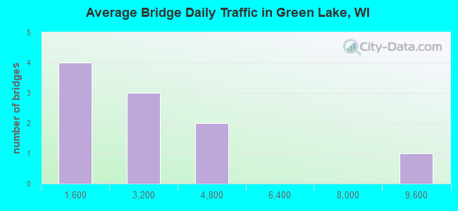
- 26,385Total average daily traffic
- 1,058Total average daily truck traffic
- 34,929Total future (year 2039) average daily traffic
- National Bridge Inventory (NBI) Registered Bridges for Green Lake
- No street view available for this location
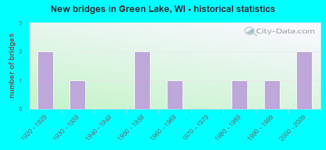
- New bridges - historical statistics
- 21920-1929
- 11930-1939
- 21950-1959
- 11960-1969
- 11980-1989
- 11990-1999
- 22000-2009
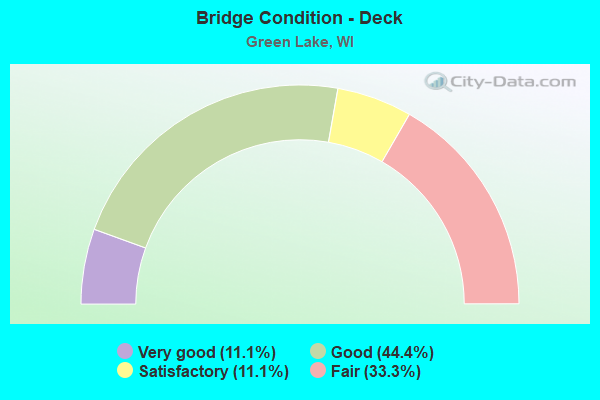
- Bridge Condition - Deck
- 11.1%Very good
- 44.4%Good
- 11.1%Satisfactory
- 33.3%Fair

- Bridge Condition - Superstructure
- 11.1%Very good
- 44.4%Good
- 11.1%Satisfactory
- 33.3%Fair
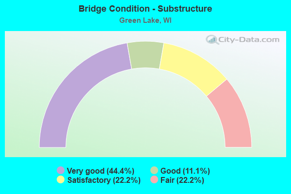
- Bridge Condition - Substructure
- 44.4%Very good
- 11.1%Good
- 22.2%Satisfactory
- 22.2%Fair
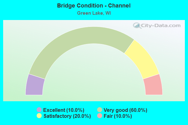
- Bridge Condition - Channel
- 10.0%Excellent
- 60.0%Very good
- 20.0%Satisfactory
- 10.0%Fair
Find on map >> Show street view
Structure Number: B240004, Location: 0.9M N JCT CTH J (Lat: 43.886111, Lng: -88.946094), Route carried "on" structure: State highway 49, Year Built: 1957, Status: Open, Structure Length: 0.94m (3.08ft), Average Daily Traffic: 3,100 (year 2019), Truck Traffic: 6%, Average Future Daily Traffic: 5,660 (year 2040), Design Load: H 20, Features Intersected: BR FOX RIVER
Minimum Vertical Clearance: 30+ m (98+ ft), Kilometerpoint: 0.000, Lanes on structure: 2, Owner: State Highway Agency, Approaching Roadway Width: 13.4m (44.0ft), Skew: 4 degrees, Material/Design: Concrete continuous, Design/Construction: Culvert, Number Of Spans In Main Unit: 2, Length of Maximum Span: 3.0m (9.8ft)
Condition: Channel: Satisfactory, Culverts: Satisfactory, Operating Rating: 53.9 metric tons, Method Used To Determine Operating Rating: Field evaluation and documented engineering judgment, Inventory Rating: 24.3 metric tons, Method Used To Determine Inventory Rating: Field evaluation and documented engineering judgment, Structural Evaluation: Equal to present minimum criteria, Waterway Adequacy: Equal to present desirable criteria, Approach Roadway Alignment: Equal to present desirable criteria, Designated Inspection Frequency: Every 24 months, Inspection Date: July 2021, Deck Structure Type: Concrete Cast-file-Place, Wearing Surface/Protective System: Wearing Surface: Bituminous
Find on map >> Show street view
Structure Number: B240005, Location: 1.2M N JCT CTH K (Lat: 43.824378, Lng: -88.926517), Route carried "on" structure: County highway , Year Built: 1958, Status: Open, Structure Length: 0.92m (3.02ft), Average Daily Traffic: 4,441 (year 2019), Average Future Daily Traffic: 4,885 (year 2040), Design Load: H 15, Features Intersected: SILVER CREEK, Facility Carried by Structure: CTH A
Minimum Vertical Clearance: 30+ m (98+ ft), Kilometerpoint: 0.000, Lanes on structure: 2, Owner: County Highway Agency, Approaching Roadway Width: 10.4m (34.1ft), Material/Design: Concrete, Design/Construction: Frame, Number Of Spans In Main Unit: 1, Length of Maximum Span: 8.9m (29.2ft), Curb or Sidewalk Widths: Left: 0.0m, Right: 2.0m (6.6ft), Curb-To-Curb Width: 9.5m (31.2ft), Out-to-Out Width: 11.9m (39.0ft)
Condition: Deck: Fair, Superstructure: Fair, Substructure: Satisfactory, Channel: Very good, Operating Rating: 44.1 metric tons, Method Used To Determine Operating Rating: Load Factor (LF), Inventory Rating: 32.4 metric tons, Method Used To Determine Inventory Rating: Load Factor (LF), Structural Evaluation: Somewhat better than minimum adequacy, Deck Geometry: Meets minimum limits, Waterway Adequacy: Equal to present desirable criteria, Approach Roadway Alignment: Equal to present desirable criteria, Designated Inspection Frequency: Every 24 months, Inspection Date: September 2021, Deck Structure Type: Concrete Cast-file-Place, Wearing Surface/Protective System: Wearing Surface: Bituminous
Find on map >> Show street view
Structure Number: B240009, Location: 1.1M E JCT CTH A (Lat: 43.854625, Lng: -88.949978), Route carried "on" structure: State highway 23, Year Built: 1966, Status: Open, Structure Length: 10.23m (33.56ft), Average Daily Traffic: 8,700 (year 2019), Truck Traffic: 8%, Average Future Daily Traffic: 12,160 (year 2040), Design Load: H 20, Features Intersected: PUCHYAN RIVER
Minimum Vertical Clearance: 30+ m (98+ ft), Kilometerpoint: 0.000, Lanes on structure: 3, Base Highway Network: Yes, Owner: State Highway Agency, Approaching Roadway Width: 17.1m (56.1ft), Skew: 4 degrees, Material/Design: Prestressed concrete continuous, Design/Construction: Stringer/Multi-beam, Number Of Spans In Main Unit: 4, Length of Maximum Span: 25.0m (82.0ft), Curb-To-Curb Width: 17.1m (56.1ft), Out-to-Out Width: 18.0m (59.1ft)
Condition: Deck: Good, Superstructure: Good, Substructure: Good, Channel: Very good, Operating Rating: 44.1 metric tons, Method Used To Determine Operating Rating: Load Factor (LF), Inventory Rating: 25.9 metric tons, Method Used To Determine Inventory Rating: Load Factor (LF), Structural Evaluation: Equal to present minimum criteria, Deck Geometry: Superior to present desirable criteria, Waterway Adequacy: Equal to present desirable criteria, Approach Roadway Alignment: Equal to present desirable criteria, Designated Inspection Frequency: Every 24 months, Inspection Date: June 2021, Deck Structure Type: Concrete Cast-file-Place, Wearing Surface/Protective System: Wearing Surface: Epoxy Overlay
Find on map >> Show street view
Structure Number: B240016, Location: 1.6M E JCT CTH A (Lat: 43.839472, Lng: -88.908169), Route carried "on" structure: City street , Year Built: 1986, Status: Open, Structure Length: 1.46m (4.79ft), Average Daily Traffic: 138 (year 2019), Average Future Daily Traffic: 151 (year 2039), Design Load: H 20, Features Intersected: SILVER CREEK, Facility Carried by Structure: LRD SPAULDING HILL
Minimum Vertical Clearance: 30+ m (98+ ft), Kilometerpoint: 0.000, Lanes on structure: 2, Owner: Town or Township Highway Agency, Approaching Roadway Width: 8.2m (26.9ft), Material/Design: Concrete, Design/Construction: Slab, Number Of Spans In Main Unit: 1, Length of Maximum Span: 14.0m (45.9ft), Curb-To-Curb Width: 7.3m (24.0ft), Out-to-Out Width: 7.9m (25.9ft)
Condition: Deck: Good, Superstructure: Good, Substructure: Very good, Channel: Very good, Operating Rating: 39.2 metric tons, Method Used To Determine Operating Rating: Load Factor (LF), Inventory Rating: 22.7 metric tons, Method Used To Determine Inventory Rating: Load Factor (LF), Structural Evaluation: Equal to present minimum criteria, Deck Geometry: Somewhat better than minimum adequacy, Waterway Adequacy: Equal to present desirable criteria, Approach Roadway Alignment: Equal to present desirable criteria, Designated Inspection Frequency: Every 24 months, Inspection Date: May 2020, Deck Structure Type: Concrete Cast-file-Place, Wearing Surface/Protective System: Wearing Surface: Monolithic Concrete, Deck Protection: Epoxy Coated Reinforcing
Find on map >> Show street view
Structure Number: B240025, Location: 0.3M W JCT CTH A (Lat: 43.873061, Lng: -88.992683), Route carried "on" structure: County highway , Year Built: 1998, Status: Open, Structure Length: 2.31m (7.58ft), Average Daily Traffic: 397 (year 2019), Average Future Daily Traffic: 436 (year 2040), Design Load: HS 20, Features Intersected: PUCHYAN RIVER, Facility Carried by Structure: CTH J
Minimum Vertical Clearance: 30+ m (98+ ft), Kilometerpoint: 0.000, Lanes on structure: 2, Owner: County Highway Agency, Approaching Roadway Width: 8.5m (27.9ft), Skew: 2 degrees, Material/Design: Concrete continuous, Design/Construction: Slab, Number Of Spans In Main Unit: 2, Length of Maximum Span: 11.0m (36.1ft), Curb-To-Curb Width: 8.4m (27.6ft), Out-to-Out Width: 9.0m (29.5ft)
Condition: Deck: Satisfactory, Superstructure: Satisfactory, Substructure: Very good, Channel: Satisfactory, Operating Rating: 70.2 metric tons, Method Used To Determine Operating Rating: Load Factor (LF), Inventory Rating: 40.5 metric tons, Method Used To Determine Inventory Rating: Load Factor (LF), Structural Evaluation: Equal to present minimum criteria, Deck Geometry: Somewhat better than minimum adequacy, Waterway Adequacy: Equal to present desirable criteria, Approach Roadway Alignment: Equal to present minimum criteria, Designated Inspection Frequency: Every 24 months, Inspection Date: September 2021, Deck Structure Type: Concrete Cast-file-Place, Wearing Surface/Protective System: Wearing Surface: Monolithic Concrete, Deck Protection: Epoxy Coated Reinforcing
Find on map >> Show street view
Structure Number: B240029, Location: 0.4M W JCT STH 49 (Lat: 43.861875, Lng: -88.946736), Route carried "on" structure: City street , Year Built: 2001, Status: Open, Structure Length: 1.48m (4.86ft), Average Daily Traffic: 268 (year 2019), Truck Traffic: 3%, Average Future Daily Traffic: 294 (year 2039), Design Load: HS 20, Features Intersected: PUCHYAN RIVER, Facility Carried by Structure: LRD BERLIN RD
Minimum Vertical Clearance: 30+ m (98+ ft), Kilometerpoint: 0.000, Lanes on structure: 2, Owner: Town or Township Highway Agency, Approaching Roadway Width: 8.5m (27.9ft), Material/Design: Concrete, Design/Construction: Slab, Number Of Spans In Main Unit: 1, Length of Maximum Span: 14.0m (45.9ft), Curb-To-Curb Width: 7.3m (24.0ft), Out-to-Out Width: 7.9m (25.9ft)
Condition: Deck: Good, Superstructure: Good, Substructure: Very good, Channel: Very good, Operating Rating: 58.8 metric tons, Method Used To Determine Operating Rating: Load Factor (LF), Inventory Rating: 34.0 metric tons, Method Used To Determine Inventory Rating: Load Factor (LF), Structural Evaluation: Better than present minimum criteria, Deck Geometry: Somewhat better than minimum adequacy, Waterway Adequacy: Equal to present desirable criteria, Approach Roadway Alignment: Equal to present desirable criteria, Designated Inspection Frequency: Every 24 months, Inspection Date: June 2020, Deck Structure Type: Concrete Cast-file-Place, Wearing Surface/Protective System: Wearing Surface: Monolithic Concrete, Deck Protection: Epoxy Coated Reinforcing
Find on map >> Show street view
Structure Number: B240032, Location: 0.9 MI S JCT CTH J (Lat: 43.860861, Lng: -88.976361), Route carried "on" structure: County highway , Year Built: 2004, Status: Open, Structure Length: 1.55m (5.09ft), Average Daily Traffic: 466 (year 2019), Average Future Daily Traffic: 512 (year 2040), Design Load: HS 20, Features Intersected: PUCHYAN RIVER, Facility Carried by Structure: CTH A
Minimum Vertical Clearance: 30+ m (98+ ft), Kilometerpoint: 0.000, Lanes on structure: 2, Owner: County Highway Agency, Approaching Roadway Width: 10.4m (34.1ft), Skew: 2 degrees, Material/Design: Prestressed concrete, Design/Construction: Box Beam or Girders - Multiple, Number Of Spans In Main Unit: 1, Length of Maximum Span: 14.6m (47.9ft), Curb-To-Curb Width: 9.4m (30.8ft), Out-to-Out Width: 9.6m (31.5ft)
Condition: Deck: Very good, Superstructure: Very good, Substructure: Very good, Channel: Fair, Operating Rating: 68.6 metric tons, Method Used To Determine Operating Rating: Load Factor (LF), Inventory Rating: 40.5 metric tons, Method Used To Determine Inventory Rating: Load Factor (LF), Structural Evaluation: Equal to present desirable criteria, Deck Geometry: Equal to present minimum criteria, Waterway Adequacy: Equal to present desirable criteria, Approach Roadway Alignment: Equal to present desirable criteria, Designated Inspection Frequency: Every 24 months, Inspection Date: September 2021, Wearing Surface/Protective System: Wearing Surface: Low Slump Concrete, Deck Protection: Epoxy Coated Reinforcing
Find on map >> Show street view
Structure Number: B240431, Location: 1.6M N JCT CTH X (Lat: 43.687631, Lng: -89.031119), Route carried "on" structure: State highway 73, Year Built: 1934, Year Reconstructed: 2001, Status: Open, Structure Length: 1.42m (4.66ft), Average Daily Traffic: 2,100 (year 2019), Truck Traffic: 8%, Average Future Daily Traffic: 3,380 (year 2040), Design Load: H 20, Features Intersected: GRAND RIVER
Minimum Vertical Clearance: 30+ m (98+ ft), Kilometerpoint: 0.000, Lanes on structure: 2, Owner: State Highway Agency, Approaching Roadway Width: 11.0m (36.1ft), Material/Design: Concrete, Design/Construction: Slab, Number Of Spans In Main Unit: 1, Length of Maximum Span: 14.2m (46.6ft), Curb-To-Curb Width: 11.0m (36.1ft), Out-to-Out Width: 11.7m (38.4ft)
Condition: Deck: Good, Superstructure: Good, Substructure: Satisfactory, Channel: Very good, Operating Rating: 58.8 metric tons, Method Used To Determine Operating Rating: Load Factor (LF), Inventory Rating: 35.6 metric tons, Method Used To Determine Inventory Rating: Load Factor (LF), Structural Evaluation: Equal to present minimum criteria, Deck Geometry: Somewhat better than minimum adequacy, Waterway Adequacy: Equal to present desirable criteria, Approach Roadway Alignment: Equal to present desirable criteria, Designated Inspection Frequency: Every 24 months, Inspection Date: July 2021, Deck Structure Type: Concrete Cast-file-Place, Wearing Surface/Protective System: Wearing Surface: Monolithic Concrete
Find on map >> Show street view
Structure Number: B240437, Location: 0.9M S JCT STH 23 (Lat: 43.846619, Lng: -88.960053), Route carried "on" structure: County highway , Year Built: 1929, Status: Open, Structure Length: 1.01m (3.31ft), Average Daily Traffic: 4,006 (year 2019), Average Future Daily Traffic: 4,406 (year 2039), Design Load: H 15, Features Intersected: PUCKYAN RIVER, Facility Carried by Structure: CTH A MILLS ST
Minimum Vertical Clearance: 30+ m (98+ ft), Kilometerpoint: 0.000, Lanes on structure: 2, Owner: City or Municipal Highway Agency, Approaching Roadway Width: 9.1m (29.9ft), Material/Design: Concrete, Design/Construction: Stringer/Multi-beam, Number Of Spans In Main Unit: 1, Length of Maximum Span: 9.6m (31.5ft), Curb or Sidewalk Widths: Left: 2.1m (6.9ft), Right: 2.0m (6.6ft), Curb-To-Curb Width: 8.2m (26.9ft), Out-to-Out Width: 12.3m (40.4ft)
Condition: Deck: Fair, Superstructure: Fair, Substructure: Fair, Channel: Very good, Operating Rating: 41.0 metric tons, Method Used To Determine Operating Rating: Load Factor (LF), Inventory Rating: 21.1 metric tons, Method Used To Determine Inventory Rating: Load Factor (LF), Structural Evaluation: Somewhat better than minimum adequacy, Deck Geometry: High priority of corrective action, Waterway Adequacy: Equal to present minimum criteria, Approach Roadway Alignment: Equal to present desirable criteria, Length Of Structure Improvement: 1.46m (4.79ft), Designated Inspection Frequency: Every 24 months, Inspection Date: June 2020, Bridge Improvement Cost: $181,000, Roadway Improvement Cost: $18,000, Total Project Cost: $272,000 ( Estimate for 2021), Deck Structure Type: Concrete Cast-file-Place, Wearing Surface/Protective System: Wearing Surface: Bituminous
Find on map >> Show street view
Structure Number: P2407, Location: 0.2M S JCT CTH A (Lat: 43.842992, Lng: -88.963183), Route carried "on" structure: City street , Year Built: 1929, Status: Open, Structure Length: 0.77m (2.53ft), Average Daily Traffic: 2,769 (year 2019), Average Future Daily Traffic: 3,045 (year 2039), Design Load: HS 20, Features Intersected: PUCHYAN RIVER, Facility Carried by Structure: LRD SOUTH LAWSON D
Minimum Vertical Clearance: 30+ m (98+ ft), Kilometerpoint: 0.000, Lanes on structure: 2, Owner: City or Municipal Highway Agency, Approaching Roadway Width: 9.4m (30.8ft), Material/Design: Concrete, Design/Construction: Stringer/Multi-beam, Number Of Spans In Main Unit: 1, Length of Maximum Span: 7.6m (24.9ft), Curb or Sidewalk Widths: Left: 2.1m (6.9ft), Right: 0.0m, Curb-To-Curb Width: 8.3m (27.2ft), Out-to-Out Width: 11.4m (37.4ft)
Condition: Deck: Fair, Superstructure: Fair, Substructure: Fair, Channel: Excellent, Operating Rating: 42.5 metric tons, Method Used To Determine Operating Rating: Load Factor (LF), Inventory Rating: 22.7 metric tons, Method Used To Determine Inventory Rating: Load Factor (LF), Structural Evaluation: Somewhat better than minimum adequacy, Deck Geometry: High priority of corrective action, Waterway Adequacy: Superior to present desirable criteria, Approach Roadway Alignment: Equal to present desirable criteria, Length Of Structure Improvement: 1.22m (4.00ft), Designated Inspection Frequency: Every 24 months, Inspection Date: June 2020, Bridge Improvement Cost: $130,000, Roadway Improvement Cost: $13,000, Total Project Cost: $195,000 ( Estimate for 2021), Deck Structure Type: Concrete Cast-file-Place, Wearing Surface/Protective System: Wearing Surface: Bituminous