Bridge Statistics for Greater Landover, Maryland (MD)
Condition, Traffic, Stress, Structural Evaluation, Project Costs
- National Bridge Inventory (NBI) Statistics
- 12Number of bridges
- 161ft / 49.3mTotal length
- $514,000Total costs
- 298,795Total average daily traffic
- 15,825Total average daily truck traffic
- National Bridge Inventory (NBI) Registered Bridges for Greater Landover
- No street view available for this location
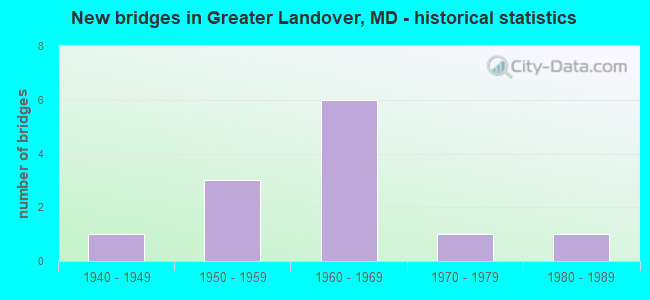
- New bridges - historical statistics
- 11940-1949
- 31950-1959
- 61960-1969
- 11970-1979
- 11980-1989

- Reconstructed bridges - Historical Statistics
- 11960-1969
- 01970-1979
- 11980-1989
- 11990-1999


- Bridge Condition - Deck
- 33.3%Good
- 16.7%Satisfactory
- 33.3%Fair
- 16.7%Poor

- Bridge Condition - Superstructure
- 16.7%Good
- 50.0%Satisfactory
- 16.7%Fair
- 16.7%Poor

- Bridge Condition - Substructure
- 66.7%Satisfactory
- 33.3%Fair

- Bridge Condition - Channel
- 12.5%Very good
- 12.5%Good
- 37.5%Satisfactory
- 37.5%Fair

- Bridge Condition - Culverts
- 25.0%Good
- 75.0%Satisfactory
Find on map >> Show street view
Structure Number: 100000160029011, Location: 0.08 MILE SOUTH OF US 50 (Lat: 38.929753, Lng: -76.895878), Route carried "on" structure: State highway 202, Year Built: 1959, Year Reconstructed: 1993, Status: Open, Structure Length: 6.61m (21.69ft), Average Daily Traffic: 47,470 (year 2016), Truck Traffic: 8%, Average Future Daily Traffic: 52,406 (year 2038), Design Load: HS 20, Features Intersected: AMTRAK, WMATA
Minimum Vertical Clearance: 30+ m (98+ ft), Kilometerpoint: 19.636, Lanes on structure: 3, Base Highway Network: Yes, Owner: State Highway Agency, Approaching Roadway Width: 10.4m (34.1ft), Material/Design: Steel, Design/Construction: Girder and Floorbeam System, Number Of Spans In Main Unit: 1, Number Of Approach Spans: 2, Length of Maximum Span: 38.1m (125.0ft), Curb-To-Curb Width: 11.5m (37.7ft), Out-to-Out Width: 13.4m (44.0ft)
Condition: Deck: Satisfactory, Superstructure: Satisfactory, Substructure: Fair, Inventory Rating: 59.9 metric tons, Method Used To Determine Inventory Rating: Load Factor (LF), Structural Evaluation: Somewhat better than minimum adequacy, Deck Geometry: High priority of replacement, Underclear: Equal to present desirable criteria, Approach Roadway Alignment: Equal to present desirable criteria, Designated Inspection Frequency: Every 24 months, Critical Feature Inspection Frequency: Every 24 months, Inspection Date: Febuary 2020, Critical Feature Inspection Date: Febuary 2020, Deck Structure Type: Concrete Cast-file-Place, Wearing Surface/Protective System: Wearing Surface: Bituminous
Find on map >> Show street view
Structure Number: 10000016003001, Location: 0.28 MILE S OF MD 977H (Lat: 38.926136, Lng: -76.874019), Route carried "on" structure: State highway 202, Year Built: 1969, Status: Open, Structure Length: 6.25m (20.51ft), Average Daily Traffic: 37,612 (year 2009), Truck Traffic: 8%, Average Future Daily Traffic: 48,348 (year 2026), Design Load: HS 20, Features Intersected: MD 704
Minimum Vertical Clearance: 30+ m (98+ ft), Kilometerpoint: 17.651, Lanes on structure: 8, Lanes under structure: 6, Base Highway Network: Yes, Owner: State Highway Agency, Approaching Roadway Width: 36.0m (118.1ft), Skew: 20 degrees, Material/Design: Steel continuous, Design/Construction: Stringer/Multi-beam, Number Of Spans In Main Unit: 2, Number Of Approach Spans: 2, Length of Maximum Span: 20.1m (65.9ft), Curb or Sidewalk Widths: Left: 1.6m (5.2ft), Right: 1.6m (5.2ft), Curb-To-Curb Width: 36.0m (118.1ft), Out-to-Out Width: 39.7m (130.2ft)
Condition: Deck: Fair, Superstructure: Satisfactory, Substructure: Satisfactory, Operating Rating: 72.6 metric tons, Method Used To Determine Operating Rating: Load Factor (LF), Inventory Rating: 43.5 metric tons, Method Used To Determine Inventory Rating: Load Factor (LF), Structural Evaluation: Equal to present minimum criteria, Deck Geometry: Superior to present desirable criteria, Underclear: Equal to present minimum criteria, Approach Roadway Alignment: Equal to present minimum criteria, Designated Inspection Frequency: Every 24 months, Inspection Date: July 2021, Deck Structure Type: Concrete Cast-file-Place, Wearing Surface/Protective System: Wearing Surface: Monolithic Concrete
Find on map >> Show street view
Structure Number: 10000016011902, Location: 0.24 MILE SOUTH OF US 50 (Lat: 38.928786, Lng: -76.893639), Route carried "on" structure: State highway 202, Year Built: 1942, Year Reconstructed: 1968, Status: Open, Structure Length: 6.89m (22.60ft), Average Daily Traffic: 45,682 (year 2009), Truck Traffic: 8%, Average Future Daily Traffic: 48,463 (year 2026), Design Load: HS 20, Features Intersected: BEAVERDAM CREEK
Minimum Vertical Clearance: 30+ m (98+ ft), Kilometerpoint: 19.421, Lanes on structure: 6, Base Highway Network: Yes, Owner: State Highway Agency, Approaching Roadway Width: 26.8m (87.9ft), Skew: 2 degrees, Material/Design: Concrete, Design/Construction: Culvert, Length of Maximum Span: 3.0m (9.8ft)
Condition: Channel: Satisfactory, Culverts: Satisfactory, Operating Rating: 32.7 metric tons, Method Used To Determine Operating Rating: Field evaluation and documented engineering judgment, Inventory Rating: 32.7 metric tons, Method Used To Determine Inventory Rating: Field evaluation and documented engineering judgment, Structural Evaluation: Equal to present minimum criteria, Waterway Adequacy: Equal to present desirable criteria, Approach Roadway Alignment: Equal to present desirable criteria, Designated Inspection Frequency: Every 24 months, Inspection Date: June 2021
Find on map >> Show street view
Structure Number: 10000016019802, Location: 0.61 MILE EAST OF MD 704 (Lat: 38.920817, Lng: -76.864731), Route carried "on" structure: State highway 202, Year Built: 1970, Status: Open, Structure Length: 3.54m (11.61ft), Average Daily Traffic: 42,242 (year 2009), Truck Traffic: 8%, Average Future Daily Traffic: 45,949 (year 2026), Design Load: HS 20, Features Intersected: CATTAIL BRANCH
Minimum Vertical Clearance: 30+ m (98+ ft), Kilometerpoint: 16.623, Lanes on structure: 6, Base Highway Network: Yes, Owner: State Highway Agency, Approaching Roadway Width: 21.9m (71.9ft), Skew: 1 degrees, Material/Design: Concrete, Design/Construction: Culvert, Length of Maximum Span: 3.4m (11.2ft)
Condition: Channel: Fair, Culverts: Good, Operating Rating: 32.7 metric tons, Method Used To Determine Operating Rating: Field evaluation and documented engineering judgment, Inventory Rating: 32.7 metric tons, Method Used To Determine Inventory Rating: Field evaluation and documented engineering judgment, Structural Evaluation: Better than present minimum criteria, Waterway Adequacy: Equal to present minimum criteria, Approach Roadway Alignment: Equal to present desirable criteria, Designated Inspection Frequency: Every 24 months, Inspection Date: March 2021
Find on map >> Show street view
Structure Number: 10000016024601, Location: 0.17 MILE EAST OF US 50 (Lat: 38.942086, Lng: -76.880458), Route carried "on" structure: State highway 410, Year Built: 1988, Status: Open, Structure Length: 17.83m (58.50ft), Average Daily Traffic: 20,822 (year 2009), Truck Traffic: 8%, Average Future Daily Traffic: 24,711 (year 2026), Design Load: HS 20+Mod, Features Intersected: AMTRAK, WMATA, BEAVER CR
Minimum Vertical Clearance: 30+ m (98+ ft), Kilometerpoint: 11.778, Lanes on structure: 5, Owner: State Highway Agency, Approaching Roadway Width: 33.2m (108.9ft), Skew: 20 degrees, Material/Design: Steel continuous, Design/Construction: Stringer/Multi-beam, Number Of Spans In Main Unit: 4, Length of Maximum Span: 44.2m (145.0ft), Curb-To-Curb Width: 28.6m (93.8ft), Out-to-Out Width: 32.0m (105.0ft)
Condition: Deck: Good, Superstructure: Good, Substructure: Fair, Channel: Very good, Operating Rating: 62.1 metric tons, Method Used To Determine Operating Rating: Load Factor (LF), Inventory Rating: 35.8 metric tons, Method Used To Determine Inventory Rating: Load Factor (LF), Structural Evaluation: Somewhat better than minimum adequacy, Deck Geometry: Superior to present desirable criteria, Underclear: High priority of corrective action, Waterway Adequacy: Superior to present desirable criteria, Approach Roadway Alignment: Equal to present desirable criteria, Designated Inspection Frequency: Every 24 months, Inspection Date: October 2020, Deck Structure Type: Concrete Cast-file-Place, Wearing Surface/Protective System: Wearing Surface: Monolithic Concrete
Find on map >> Show street view
Structure Number: 200000P-028001, Location: 0.04 MI S GREEN LEAF RD (Lat: 38.919536, Lng: -76.871750), Route carried "on" structure: County highway 1227, Year Built: 1956, Status: Posted for load, Structure Length: 2.01m (6.59ft), Average Daily Traffic: 2,030 (year 2017), Truck Traffic: 5%, Average Future Daily Traffic: 3,040 (year 2037), Design Load: HS 20, Features Intersected: CATTAIL BRANCH, Facility Carried by Structure: MATTHEW HENSON AVE
Minimum Vertical Clearance: 30+ m (98+ ft), Kilometerpoint: 0.080, Lanes on structure: 2, Owner: County Highway Agency, Approaching Roadway Width: 11.0m (36.1ft), Material/Design: Concrete continuous, Design/Construction: Tee Beam, Number Of Spans In Main Unit: 3, Length of Maximum Span: 6.7m (22.0ft), Curb or Sidewalk Widths: Left: 1.8m (5.9ft), Right: 1.8m (5.9ft), Curb-To-Curb Width: 11.0m (36.1ft), Out-to-Out Width: 14.6m (47.9ft)
Condition: Deck: Fair, Superstructure: Fair, Substructure: Satisfactory, Channel: Satisfactory, Operating Rating: 24.5 metric tons, Method Used To Determine Operating Rating: Load Factor (LF), Inventory Rating: 14.5 metric tons, Method Used To Determine Inventory Rating: Load Factor (LF), Structural Evaluation: Meets minimum limits, Deck Geometry: Somewhat better than minimum adequacy, Waterway Adequacy: Better than present minimum criteria, Approach Roadway Alignment: Equal to present desirable criteria, Bridge Posting: Required (Relationship of Operating Rating to Maximum Legal Load: 10.0 - 19.9% below), Length Of Structure Improvement: 2.01m (6.59ft), Designated Inspection Frequency: Every 12 months, Inspection Date: March 2021, Roadway Improvement Cost: $14,000, Total Project Cost: $14,000, Deck Structure Type: Concrete Cast-file-Place, Wearing Surface/Protective System: Wearing Surface: Bituminous
Find on map >> Show street view
Structure Number: 200000P-028201, Location: .14 M N OF COLUMBIA PK RD (Lat: 38.919103, Lng: -76.905642), Route carried "on" structure: County highway 1947, Year Built: 1967, Year Reconstructed: 2003, Status: Open, Structure Length: 2.04m (6.69ft), Average Daily Traffic: 1,212 (year 2015), Truck Traffic: 5%, Average Future Daily Traffic: 1,801 (year 2035), Design Load: H 20, Features Intersected: BEAVERDAM CREEK, Facility Carried by Structure: BEAVER ROAD
Minimum Vertical Clearance: 30+ m (98+ ft), Kilometerpoint: 0.225, Lanes on structure: 2, Owner: County Highway Agency, Approaching Roadway Width: 14.0m (45.9ft), Skew: 1 degrees, Material/Design: Prestressed concrete, Design/Construction: Stringer/Multi-beam, Number Of Spans In Main Unit: 1, Length of Maximum Span: 19.8m (65.0ft), Curb or Sidewalk Widths: Left: 1.5m (4.9ft), Right: 1.5m (4.9ft), Curb-To-Curb Width: 14.0m (45.9ft), Out-to-Out Width: 17.1m (56.1ft)
Condition: Deck: Good, Superstructure: Satisfactory, Substructure: Satisfactory, Channel: Fair, Operating Rating: 73.0 metric tons, Method Used To Determine Operating Rating: Load Factor (LF), Inventory Rating: 43.5 metric tons, Method Used To Determine Inventory Rating: Load Factor (LF), Structural Evaluation: Equal to present minimum criteria, Deck Geometry: Superior to present desirable criteria, Waterway Adequacy: Somewhat better than minimum adequacy, Approach Roadway Alignment: High priority of corrective action, Designated Inspection Frequency: Every 24 months, Inspection Date: August 2021, Deck Structure Type: Concrete Cast-file-Place, Wearing Surface/Protective System: Wearing Surface: Monolithic Concrete
Find on map >> Show street view
Structure Number: 200000P-028602, Location: 0.01 MI N OF W FOREST RD (Lat: 38.923469, Lng: -76.887708), Route carried "on" structure: County highway 3686, Year Built: 1969, Status: Posted for load, Structure Length: 1.46m (4.79ft), Average Daily Traffic: 790 (year 2019), Truck Traffic: 10%, Average Future Daily Traffic: 1,175 (year 2039), Features Intersected: CATTAIL BRANCH, Facility Carried by Structure: VIRGINIA AVENUE
Minimum Vertical Clearance: 30+ m (98+ ft), Kilometerpoint: 0.145, Lanes on structure: 2, Owner: County Highway Agency, Approaching Roadway Width: 11.0m (36.1ft), Material/Design: Concrete, Design/Construction: Culvert, Number Of Spans In Main Unit: 4, Length of Maximum Span: 3.4m (11.2ft), Curb or Sidewalk Widths: Left: 1.2m (3.9ft), Right: 1.5m (4.9ft)
Condition: Channel: Fair, Culverts: Satisfactory, Operating Rating: 49.0 metric tons, Method Used To Determine Operating Rating: Load Factor (LF), Inventory Rating: 29.0 metric tons, Method Used To Determine Inventory Rating: Load Factor (LF), Structural Evaluation: Equal to present minimum criteria, Waterway Adequacy: Better than present minimum criteria, Approach Roadway Alignment: Equal to present minimum criteria, Designated Inspection Frequency: Every 24 months, Inspection Date: Febuary 2021
Find on map >> Show street view
Structure Number: 200000P-028802, Location: 500 FT S OF MD RTE 202 (Lat: 38.926464, Lng: -76.890539), Route carried "on" structure: County highway 44, Year Built: 1969, Status: Posted for load, Structure Length: 1.16m (3.81ft), Average Daily Traffic: 633 (year 2019), Truck Traffic: 10%, Average Future Daily Traffic: 940 (year 2039), Features Intersected: CATTAIL BRANCH, Facility Carried by Structure: PINEBROOK AVENUE
Minimum Vertical Clearance: 30+ m (98+ ft), Kilometerpoint: 0.515, Lanes on structure: 2, Owner: County Highway Agency, Approaching Roadway Width: 17.1m (56.1ft), Skew: 20 degrees, Material/Design: Concrete, Design/Construction: Culvert, Number Of Spans In Main Unit: 3, Length of Maximum Span: 3.7m (12.1ft), Curb or Sidewalk Widths: Left: 1.2m (3.9ft), Right: 1.2m (3.9ft)
Condition: Channel: Good, Culverts: Satisfactory, Operating Rating: 46.7 metric tons, Method Used To Determine Operating Rating: Load Factor (LF), Inventory Rating: 28.1 metric tons, Method Used To Determine Inventory Rating: Load Factor (LF), Structural Evaluation: Equal to present minimum criteria, Waterway Adequacy: Better than present minimum criteria, Approach Roadway Alignment: Equal to present desirable criteria, Designated Inspection Frequency: Every 24 months, Inspection Date: Febuary 2021
Find on map >> Show street view
Structure Number: 200000P-028901, Location: 0.14 MI N OF MD 202 (Lat: 38.929472, Lng: -76.893186), Route carried "on" structure: County highway 1210, Year Built: 1966, Status: Posted for load, Structure Length: 1.55m (5.09ft), Average Daily Traffic: 150 (year 2019), Truck Traffic: 13%, Average Future Daily Traffic: 230 (year 2039), Design Load: HS 20, Features Intersected: BEAVERDAM CREEK, Facility Carried by Structure: OLD LANDOVER ROAD
Minimum Vertical Clearance: 30+ m (98+ ft), Kilometerpoint: 0.225, Lanes on structure: 2, Owner: County Highway Agency, Approaching Roadway Width: 11.0m (36.1ft), Skew: 1 degrees, Material/Design: Prestressed concrete, Design/Construction: Stringer/Multi-beam, Number Of Spans In Main Unit: 1, Length of Maximum Span: 14.9m (48.9ft), Curb or Sidewalk Widths: Left: 0.3m (1.0ft), Right: 1.2m (3.9ft), Curb-To-Curb Width: 11.0m (36.1ft), Out-to-Out Width: 12.8m (42.0ft)
Condition: Deck: Poor, Superstructure: Poor, Substructure: Satisfactory, Channel: Satisfactory, Operating Rating: 34.0 metric tons, Method Used To Determine Operating Rating: Load Factor (LF), Inventory Rating: 19.0 metric tons, Method Used To Determine Inventory Rating: Load Factor (LF), Structural Evaluation: Meets minimum limits, Deck Geometry: Equal to present desirable criteria, Waterway Adequacy: Equal to present minimum criteria, Approach Roadway Alignment: Equal to present desirable criteria, Length Of Structure Improvement: 1.98m (6.50ft), Designated Inspection Frequency: Every 12 months, Inspection Date: March 2021, Bridge Improvement Cost: $100,000, Roadway Improvement Cost: $400,000, Total Project Cost: $500,000, Deck Structure Type: Concrete Precast Panels, Wearing Surface/Protective System: Wearing Surface: Bituminous
Find on map >> Show street view
Structure Number: 10000016003001, Location: 1.35 MILES WEST OF IS 95 (Lat: 38.926136, Lng: -76.874019), Route carried "under" structure: State highway 704, Year Built: 1969, Structure Length: 0. m, Average Daily Traffic: 27,730 (year 2009), Features Intersected: MD 704, Facility Carried by Structure: MD 202
Minimum Vertical Clearance: 5.18m (16.99ft), Kilometerpoint: 4.859, Lanes on structure: 8, Lanes under structure: 6, Material/Design: Steel continuous, Design/Construction: Stringer/Multi-beam, Length of Maximum Span: 20.1m (65.9ft)
Find on map >> Show street view
Structure Number: 10000016010501, Location: 1.3 MILES WEST OF MD 410 (Lat: 38.930300, Lng: -76.897136), Route carried "under" structure: US 50, Year Built: 1959, Structure Length: 0. m, Average Daily Traffic: 72,422 (year 2009), Features Intersected: US 50, Facility Carried by Structure: MD 202
Minimum Vertical Clearance: 4.88m (16.01ft), Kilometerpoint: 4.505, Lanes on structure: 6, Lanes under structure: 6, Material/Design: Steel, Design/Construction: Stringer/Multi-beam, Length of Maximum Span: 22.6m (74.1ft)