Bridge Statistics for Grayling, Michigan (MI)
Condition, Traffic, Stress, Structural Evaluation, Project Costs
- National Bridge Inventory (NBI) Statistics
- 31Number of bridges
- 187ft / 56.7mTotal length
- 175,470Total average daily traffic
- 16,647Total average daily truck traffic
- National Bridge Inventory (NBI) Registered Bridges for Grayling
- No street view available for this location
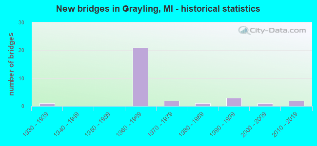
- New bridges - historical statistics
- 11930-1939
- 211960-1969
- 21970-1979
- 11980-1989
- 31990-1999
- 12000-2009
- 22010-2019

- Reconstructed bridges - Historical Statistics
- 11980-1989
- 01990-1999
- 12000-2009


- Bridge Condition - Deck
- 20.0%Very good
- 10.0%Good
- 30.0%Satisfactory
- 40.0%Fair

- Bridge Condition - Superstructure
- 5.0%Excellent
- 15.0%Very good
- 15.0%Good
- 20.0%Satisfactory
- 35.0%Fair
- 10.0%Serious

- Bridge Condition - Substructure
- 5.0%Excellent
- 5.0%Very good
- 15.0%Good
- 35.0%Satisfactory
- 15.0%Fair
- 20.0%Poor
- 5.0%Serious

- Bridge Condition - Channel
- 50.0%Very good
- 41.7%Good
- 8.3%Satisfactory
Find on map >> Show street view
Structure Number: 2031, Location: IN GRAYLING (Lat: 44.659678, Lng: -84.712303), Route carried "on" structure: Business Interstate 75, Year Built: 1935, Status: Open, Structure Length: 1.22m (4.00ft), Average Daily Traffic: 13,375 (year 2015), Truck Traffic: 4%, Average Future Daily Traffic: 14,775 (year 2035), Design Load: H 15, Features Intersected: AU SABLE RIVER
Minimum Vertical Clearance: 30.48m (100.00ft), Kilometerpoint: 1.587, Lanes on structure: 4, Base Highway Network: Yes (Inventory Route: 53, Subroute: 4), Owner: State Highway Agency, Approaching Roadway Width: 12.6m (41.3ft), Skew: 3 degrees, Material/Design: Steel, Design/Construction: Stringer/Multi-beam, Number Of Spans In Main Unit: 1, Length of Maximum Span: 12.2m (40.0ft), Curb or Sidewalk Widths: Left: 1.5m (4.9ft), Right: 1.5m (4.9ft), Curb-To-Curb Width: 12.8m (42.0ft), Out-to-Out Width: 16.8m (55.1ft)
Condition: Deck: Satisfactory, Superstructure: Good, Substructure: Fair, Channel: Good, Operating Rating: 68.4 metric tons, Method Used To Determine Operating Rating: Load Factor (LF) rating reported by rating factor (RF) method using MS18 loading, Inventory Rating: 41.1 metric tons, Method Used To Determine Inventory Rating: Load Factor (LF) rating reported by rating factor (RF) method using MS18 loading, Structural Evaluation: Somewhat better than minimum adequacy, Deck Geometry: High priority of replacement, Waterway Adequacy: Equal to present desirable criteria, Approach Roadway Alignment: Better than present minimum criteria, Designated Inspection Frequency: Every 24 months, Inspection Date: May 2021, Deck Structure Type: Concrete Cast-file-Place, Wearing Surface/Protective System: Wearing Surface: Bituminous, Membrane: Preformed Fabric
Find on map >> Show street view
Structure Number: 2033, Location: 0.5 MI S OF M-72 (Lat: 44.651811, Lng: -84.703036), Route carried "on" structure: Interstate 75, Year Built: 1961, Year Reconstructed: 1991, Status: Open, Structure Length: 4.36m (14.30ft), Average Daily Traffic: 5,877 (year 2007), Truck Traffic: 12%, Average Future Daily Traffic: 10,388 (year 2018), Design Load: HS 20+Mod, Features Intersected: LAKE STATE RR
Minimum Vertical Clearance: 30.48m (100.00ft), Kilometerpoint: 16.899, Lanes on structure: 2, Base Highway Network: Yes (Inventory Route: 53, Subroute: 2), Owner: State Highway Agency, Approaching Roadway Width: 14.6m (47.9ft), Skew: 1 degrees, Material/Design: Steel, Design/Construction: Stringer/Multi-beam, Number Of Spans In Main Unit: 3, Length of Maximum Span: 14.6m (47.9ft), Curb-To-Curb Width: 13.4m (44.0ft), Out-to-Out Width: 14.3m (46.9ft)
Condition: Deck: Fair, Superstructure: Fair, Substructure: Serious, Operating Rating: 62.2 metric tons, Method Used To Determine Operating Rating: Load Factor (LF) rating reported by rating factor (RF) method using MS18 loading, Inventory Rating: 37.3 metric tons, Method Used To Determine Inventory Rating: Load Factor (LF) rating reported by rating factor (RF) method using MS18 loading, Structural Evaluation: High priority of corrective action, Deck Geometry: Superior to present desirable criteria, Approach Roadway Alignment: Equal to present minimum criteria, Designated Inspection Frequency: Every 12 months, Inspection Date: September 2021, Deck Structure Type: Concrete Cast-file-Place, Wearing Surface/Protective System: Wearing Surface: Monolithic Concrete
Find on map >> Show street view
Structure Number: 2035, Location: @ S JCT I-75 BL (Lat: 44.644700, Lng: -84.707856), Route carried "on" structure: Ramp Interstate 75, Year Built: 1961, Year Reconstructed: 2008, Status: Open, Structure Length: 6.24m (20.47ft), Average Daily Traffic: 4,810 (year 2007), Truck Traffic: 10%, Average Future Daily Traffic: 4,887 (year 2018), Design Load: HS 20, Features Intersected: I-75 SB
Minimum Vertical Clearance: 30.48m (100.00ft), Kilometerpoint: 0.325, Lanes on structure: 1, Lanes under structure: 2, Owner: State Highway Agency, Approaching Roadway Width: 6.6m (21.7ft), Skew: 5 degrees, Material/Design: Steel, Design/Construction: Stringer/Multi-beam, Number Of Spans In Main Unit: 3, Length of Maximum Span: 27.1m (88.9ft), Curb-To-Curb Width: 6.6m (21.7ft), Out-to-Out Width: 7.9m (25.9ft)
Condition: Deck: Satisfactory, Superstructure: Fair, Substructure: Fair, Operating Rating: 75.2 metric tons, Method Used To Determine Operating Rating: Load Factor (LF) rating reported by rating factor (RF) method using MS18 loading, Inventory Rating: 44.7 metric tons, Method Used To Determine Inventory Rating: Load Factor (LF) rating reported by rating factor (RF) method using MS18 loading, Structural Evaluation: Somewhat better than minimum adequacy, Deck Geometry: Somewhat better than minimum adequacy, Underclear: Somewhat better than minimum adequacy, Approach Roadway Alignment: Equal to present minimum criteria, Designated Inspection Frequency: Every 24 months, Inspection Date: September 2021, Deck Structure Type: Concrete Cast-file-Place, Wearing Surface/Protective System: Wearing Surface: Epoxy Overlay
Find on map >> Show street view
Structure Number: 2036, Location: @ I-75, M-72 JCT (Lat: 44.656525, Lng: -84.700325), Route carried "on" structure: Interstate 75, Year Built: 1961, Status: Open, Structure Length: 4.11m (13.48ft), Average Daily Traffic: 5,877 (year 2007), Truck Traffic: 12%, Average Future Daily Traffic: 9,595 (year 2018), Design Load: HS 20+Mod, Features Intersected: M-72
Minimum Vertical Clearance: 30.48m (100.00ft), Kilometerpoint: 17.522, Lanes on structure: 2, Lanes under structure: 2, Base Highway Network: Yes (Inventory Route: 53, Subroute: 1), Owner: State Highway Agency, Approaching Roadway Width: 14.6m (47.9ft), Skew: 2 degrees, Material/Design: Steel, Design/Construction: Stringer/Multi-beam, Number Of Spans In Main Unit: 3, Length of Maximum Span: 15.9m (52.2ft), Curb-To-Curb Width: 12.8m (42.0ft), Out-to-Out Width: 14.2m (46.6ft)
Condition: Deck: Fair, Superstructure: Fair, Substructure: Poor, Operating Rating: 71.3 metric tons, Method Used To Determine Operating Rating: Load Factor (LF) rating reported by rating factor (RF) method using MS18 loading, Inventory Rating: 42.8 metric tons, Method Used To Determine Inventory Rating: Load Factor (LF) rating reported by rating factor (RF) method using MS18 loading, Structural Evaluation: Meets minimum limits, Deck Geometry: Equal to present desirable criteria, Underclear: Meets minimum limits, Approach Roadway Alignment: Better than present minimum criteria, Designated Inspection Frequency: Every 12 months, Inspection Date: September 2021, Deck Structure Type: Concrete Cast-file-Place, Wearing Surface/Protective System: Wearing Surface: Epoxy Overlay
Find on map >> Show street view
Structure Number: 2037, Location: @ I-75, M-72 JCT (Lat: 44.656511, Lng: -84.699664), Route carried "on" structure: Interstate 75, Year Built: 1961, Status: Open, Structure Length: 4.11m (13.48ft), Average Daily Traffic: 5,877 (year 2007), Truck Traffic: 12%, Average Future Daily Traffic: 9,595 (year 2018), Design Load: HS 20+Mod, Features Intersected: M-72
Minimum Vertical Clearance: 30.48m (100.00ft), Kilometerpoint: 17.486, Lanes on structure: 2, Lanes under structure: 2, Base Highway Network: Yes (Inventory Route: 53, Subroute: 2), Owner: State Highway Agency, Approaching Roadway Width: 14.6m (47.9ft), Skew: 2 degrees, Material/Design: Steel, Design/Construction: Stringer/Multi-beam, Number Of Spans In Main Unit: 3, Length of Maximum Span: 15.9m (52.2ft), Curb-To-Curb Width: 12.8m (42.0ft), Out-to-Out Width: 14.2m (46.6ft)
Condition: Deck: Fair, Superstructure: Fair, Substructure: Poor, Operating Rating: 73.5 metric tons, Method Used To Determine Operating Rating: Load Factor (LF) rating reported by rating factor (RF) method using MS18 loading, Inventory Rating: 44.1 metric tons, Method Used To Determine Inventory Rating: Load Factor (LF) rating reported by rating factor (RF) method using MS18 loading, Structural Evaluation: Meets minimum limits, Deck Geometry: Equal to present desirable criteria, Underclear: Meets minimum limits, Approach Roadway Alignment: Equal to present minimum criteria, Designated Inspection Frequency: Every 12 months, Inspection Date: September 2021, Deck Structure Type: Concrete Cast-file-Place, Wearing Surface/Protective System: Wearing Surface: Latex Concrete
Find on map >> Show street view
Structure Number: 2038, Location: 0.7 MI N OF M-72 (Lat: 44.666297, Lng: -84.697058), Route carried "on" structure: Interstate 75, Year Built: 1960, Status: Open, Structure Length: 2.13m (6.99ft), Average Daily Traffic: 5,877 (year 2007), Truck Traffic: 12%, Average Future Daily Traffic: 9,595 (year 2018), Design Load: HS 20+Mod, Features Intersected: AU SABLE RIVER
Minimum Vertical Clearance: 30.48m (100.00ft), Kilometerpoint: 18.650, Lanes on structure: 2, Base Highway Network: Yes (Inventory Route: 53, Subroute: 1), Owner: State Highway Agency, Approaching Roadway Width: 13.7m (44.9ft), Skew: 2 degrees, Material/Design: Steel, Design/Construction: Stringer/Multi-beam, Number Of Spans In Main Unit: 1, Length of Maximum Span: 21.3m (69.9ft), Curb-To-Curb Width: 12.8m (42.0ft), Out-to-Out Width: 14.3m (46.9ft)
Condition: Deck: Satisfactory, Superstructure: Satisfactory, Substructure: Satisfactory, Channel: Good, Operating Rating: 79.1 metric tons, Method Used To Determine Operating Rating: Load Factor (LF) rating reported by rating factor (RF) method using MS18 loading, Inventory Rating: 47.3 metric tons, Method Used To Determine Inventory Rating: Load Factor (LF) rating reported by rating factor (RF) method using MS18 loading, Structural Evaluation: Equal to present minimum criteria, Deck Geometry: Equal to present desirable criteria, Waterway Adequacy: Equal to present desirable criteria, Approach Roadway Alignment: Better than present minimum criteria, Designated Inspection Frequency: Every 24 months, Inspection Date: May 2020, Deck Structure Type: Concrete Cast-file-Place, Wearing Surface/Protective System: Wearing Surface: Epoxy Overlay
Find on map >> Show street view
Structure Number: 204, Location: 2.4 MI N OF M-72 (Lat: 44.688364, Lng: -84.699303), Route carried "on" structure: Interstate 75, Year Built: 1961, Status: Open, Structure Length: 1.22m (4.00ft), Average Daily Traffic: 7,158 (year 2007), Truck Traffic: 11%, Average Future Daily Traffic: 8,178 (year 2018), Design Load: HS 20+Mod, Features Intersected: E BR AU SABLE RIVER
Minimum Vertical Clearance: 30.48m (100.00ft), Kilometerpoint: 21.144, Lanes on structure: 2, Base Highway Network: Yes (Inventory Route: 53, Subroute: 1), Owner: State Highway Agency, Approaching Roadway Width: 13.7m (44.9ft), Material/Design: Steel, Design/Construction: Stringer/Multi-beam, Number Of Spans In Main Unit: 1, Length of Maximum Span: 12.2m (40.0ft), Curb-To-Curb Width: 12.8m (42.0ft), Out-to-Out Width: 14.3m (46.9ft)
Condition: Deck: Satisfactory, Superstructure: Satisfactory, Substructure: Satisfactory, Channel: Satisfactory, Operating Rating: 61.6 metric tons, Method Used To Determine Operating Rating: Load Factor (LF) rating reported by rating factor (RF) method using MS18 loading, Inventory Rating: 36.9 metric tons, Method Used To Determine Inventory Rating: Load Factor (LF) rating reported by rating factor (RF) method using MS18 loading, Structural Evaluation: Equal to present minimum criteria, Deck Geometry: Equal to present desirable criteria, Waterway Adequacy: Equal to present desirable criteria, Approach Roadway Alignment: Better than present minimum criteria, Designated Inspection Frequency: Every 24 months, Inspection Date: May 2020, Deck Structure Type: Concrete Cast-file-Place, Wearing Surface/Protective System: Wearing Surface: Epoxy Overlay
Find on map >> Show street view
Structure Number: 2041, Location: 2.4 MI N OF M-72 (Lat: 44.691508, Lng: -84.697464), Route carried "on" structure: Interstate 75, Year Built: 1961, Status: Open, Structure Length: 1.22m (4.00ft), Average Daily Traffic: 7,158 (year 2007), Truck Traffic: 11%, Average Future Daily Traffic: 8,178 (year 2018), Design Load: HS 20+Mod, Features Intersected: E BR AU SABLE RIVER
Minimum Vertical Clearance: 30.48m (100.00ft), Kilometerpoint: 21.432, Lanes on structure: 2, Base Highway Network: Yes (Inventory Route: 53, Subroute: 2), Owner: State Highway Agency, Approaching Roadway Width: 13.7m (44.9ft), Skew: 1 degrees, Material/Design: Steel, Design/Construction: Stringer/Multi-beam, Number Of Spans In Main Unit: 1, Length of Maximum Span: 12.2m (40.0ft), Curb-To-Curb Width: 12.8m (42.0ft), Out-to-Out Width: 14.3m (46.9ft)
Condition: Deck: Fair, Superstructure: Satisfactory, Substructure: Satisfactory, Channel: Very good, Operating Rating: 65.4 metric tons, Method Used To Determine Operating Rating: Load Factor (LF) rating reported by rating factor (RF) method using MS18 loading, Inventory Rating: 39.2 metric tons, Method Used To Determine Inventory Rating: Load Factor (LF) rating reported by rating factor (RF) method using MS18 loading, Structural Evaluation: Equal to present minimum criteria, Deck Geometry: Equal to present desirable criteria, Waterway Adequacy: Equal to present desirable criteria, Approach Roadway Alignment: Better than present minimum criteria, Designated Inspection Frequency: Every 24 months, Inspection Date: May 2020, Deck Structure Type: Concrete Cast-file-Place, Wearing Surface/Protective System: Wearing Surface: Epoxy Overlay
Find on map >> Show street view
Structure Number: 2042, Location: 1.0 MI N OF M-72 (Lat: 44.670936, Lng: -84.695867), Route carried "on" structure: County highway 2054, Year Built: 1961, Status: Open, Structure Length: 8.11m (26.61ft), Average Daily Traffic: 780 (year 1974), Average Future Daily Traffic: 780 (year 1977), Design Load: HS 20, Features Intersected: I-75, Facility Carried by Structure: N DOWN RIVER RD
Minimum Vertical Clearance: 30.48m (100.00ft), Kilometerpoint: 1.976, Lanes on structure: 2, Lanes under structure: 4, Owner: State Highway Agency, Approaching Roadway Width: 12.8m (42.0ft), Material/Design: Steel, Design/Construction: Stringer/Multi-beam, Number Of Spans In Main Unit: 6, Length of Maximum Span: 17.3m (56.8ft), Curb-To-Curb Width: 8.7m (28.5ft), Out-to-Out Width: 10.0m (32.8ft)
Condition: Deck: Fair, Superstructure: Fair, Substructure: Fair, Operating Rating: 58.0 metric tons, Method Used To Determine Operating Rating: Load Factor (LF) rating reported by rating factor (RF) method using MS18 loading, Inventory Rating: 34.7 metric tons, Method Used To Determine Inventory Rating: Load Factor (LF) rating reported by rating factor (RF) method using MS18 loading, Structural Evaluation: Somewhat better than minimum adequacy, Deck Geometry: Somewhat better than minimum adequacy, Underclear: Somewhat better than minimum adequacy, Approach Roadway Alignment: Somewhat better than minimum adequacy, Designated Inspection Frequency: Every 16 months, Other Special Inspection Frequency: Every 12 months, Inspection Date: May 2021, Other Special Inspection Date: September 2021, Deck Structure Type: Concrete Cast-file-Place, Wearing Surface/Protective System: Wearing Surface: Latex Concrete
Find on map >> Show street view
Structure Number: 2044, Location: 3.3 MI N OF M-72 (Lat: 44.704433, Lng: -84.699986), Route carried "on" structure: Interstate 75, Year Built: 1961, Status: Open, Structure Length: 3.01m (9.88ft), Average Daily Traffic: 7,158 (year 2007), Truck Traffic: 11%, Average Future Daily Traffic: 8,178 (year 2018), Design Load: HS 20, Features Intersected: LEWISTON GRADE ROAD
Minimum Vertical Clearance: 30.48m (100.00ft), Kilometerpoint: 22.936, Lanes on structure: 2, Lanes under structure: 2, Base Highway Network: Yes (Inventory Route: 53, Subroute: 1), Owner: State Highway Agency, Approaching Roadway Width: 13.7m (44.9ft), Material/Design: Prestressed concrete, Design/Construction: Stringer/Multi-beam, Number Of Spans In Main Unit: 3, Length of Maximum Span: 10.0m (32.8ft), Curb-To-Curb Width: 12.8m (42.0ft), Out-to-Out Width: 14.3m (46.9ft)
Condition: Deck: Satisfactory, Superstructure: Satisfactory, Substructure: Satisfactory, Operating Rating: 69.3 metric tons, Method Used To Determine Operating Rating: Load Factor (LF) rating reported by rating factor (RF) method using MS18 loading, Inventory Rating: 41.5 metric tons, Method Used To Determine Inventory Rating: Load Factor (LF) rating reported by rating factor (RF) method using MS18 loading, Structural Evaluation: Equal to present minimum criteria, Deck Geometry: Equal to present desirable criteria, Underclear: Better than present minimum criteria, Approach Roadway Alignment: Equal to present desirable criteria, Designated Inspection Frequency: Every 24 months, Inspection Date: September 2021, Deck Structure Type: Concrete Cast-file-Place, Wearing Surface/Protective System: Wearing Surface: Epoxy Overlay
Find on map >> Show street view
Structure Number: 2045, Location: @ I-75, M-93 JCT (Lat: 44.714664, Lng: -84.699797), Route carried "on" structure: State highway 93, Year Built: 1961, Status: Open, Structure Length: 5.27m (17.29ft), Average Daily Traffic: 1,921 (year 2007), Truck Traffic: 10%, Average Future Daily Traffic: 2,779 (year 2018), Design Load: HS 20, Features Intersected: I-75 SB
Minimum Vertical Clearance: 30.48m (100.00ft), Kilometerpoint: 9.145, Lanes on structure: 2, Lanes under structure: 2, Base Highway Network: Yes (Inventory Route: 53, Subroute: 4), Owner: State Highway Agency, Approaching Roadway Width: 12.8m (42.0ft), Skew: 4 degrees, Material/Design: Steel, Design/Construction: Stringer/Multi-beam, Number Of Spans In Main Unit: 3, Length of Maximum Span: 22.5m (73.8ft), Curb-To-Curb Width: 10.4m (34.1ft), Out-to-Out Width: 11.2m (36.7ft)
Condition: Deck: Fair, Superstructure: Serious, Substructure: Poor, Operating Rating: 62.2 metric tons, Method Used To Determine Operating Rating: Load Factor (LF) rating reported by rating factor (RF) method using MS18 loading, Inventory Rating: 37.3 metric tons, Method Used To Determine Inventory Rating: Load Factor (LF) rating reported by rating factor (RF) method using MS18 loading, Structural Evaluation: High priority of corrective action, Deck Geometry: Equal to present minimum criteria, Underclear: Better than present minimum criteria, Approach Roadway Alignment: Equal to present minimum criteria, Designated Inspection Frequency: Every 12 months, Inspection Date: September 2021, Deck Structure Type: Concrete Cast-file-Place, Wearing Surface/Protective System: Wearing Surface: Epoxy Overlay
Find on map >> Show street view
Structure Number: 2046, Location: @ I-75, M-93 JCT (Lat: 44.715058, Lng: -84.699086), Route carried "on" structure: State highway 93, Year Built: 1961, Status: Open, Structure Length: 5.12m (16.80ft), Average Daily Traffic: 1,921 (year 2007), Truck Traffic: 10%, Average Future Daily Traffic: 2,779 (year 2018), Design Load: HS 20, Features Intersected: I-75 NB
Minimum Vertical Clearance: 30.48m (100.00ft), Kilometerpoint: 9.215, Lanes on structure: 2, Lanes under structure: 2, Base Highway Network: Yes (Inventory Route: 53, Subroute: 4), Owner: State Highway Agency, Approaching Roadway Width: 12.8m (42.0ft), Skew: 4 degrees, Material/Design: Steel, Design/Construction: Stringer/Multi-beam, Number Of Spans In Main Unit: 3, Length of Maximum Span: 22.5m (73.8ft), Curb-To-Curb Width: 10.4m (34.1ft), Out-to-Out Width: 11.2m (36.7ft)
Condition: Deck: Fair, Superstructure: Serious, Substructure: Poor, Operating Rating: 58.3 metric tons, Method Used To Determine Operating Rating: Load Factor (LF) rating reported by rating factor (RF) method using MS18 loading, Inventory Rating: 35.0 metric tons, Method Used To Determine Inventory Rating: Load Factor (LF) rating reported by rating factor (RF) method using MS18 loading, Structural Evaluation: High priority of corrective action, Deck Geometry: Equal to present minimum criteria, Underclear: High priority of corrective action, Approach Roadway Alignment: Equal to present minimum criteria, Designated Inspection Frequency: Every 12 months, Inspection Date: September 2021, Deck Structure Type: Concrete Cast-file-Place, Wearing Surface/Protective System: Wearing Surface: Epoxy Overlay
Find on map >> Show street view
Structure Number: 2053, Location: IN GRAYLING (Lat: 44.658019, Lng: -84.726081), Route carried "on" structure: State highway 72, Year Built: 1993, Status: Open, Structure Length: 1.67m (5.48ft), Average Daily Traffic: 11,731 (year 2007), Truck Traffic: 12%, Average Future Daily Traffic: 11,449 (year 2018), Design Load: HS 25 or greater, Features Intersected: AU SABLE RIVER
Minimum Vertical Clearance: 30.48m (100.00ft), Kilometerpoint: 11.008, Lanes on structure: 4, Base Highway Network: Yes (Inventory Route: 53, Subroute: 3), Owner: State Highway Agency, Approaching Roadway Width: 15.9m (52.2ft), Skew: 4 degrees, Material/Design: Prestressed concrete, Design/Construction: Box Beam or Girders - Multiple, Number Of Spans In Main Unit: 1, Length of Maximum Span: 16.7m (54.8ft), Curb-To-Curb Width: 16.5m (54.1ft), Out-to-Out Width: 16.8m (55.1ft)
Condition: Deck: Fair, Superstructure: Fair, Substructure: Satisfactory, Channel: Very good, Operating Rating: 97.2 metric tons, Method Used To Determine Operating Rating: Load Factor (LF) rating reported by rating factor (RF) method using MS18 loading, Inventory Rating: 59.3 metric tons, Method Used To Determine Inventory Rating: Load Factor (LF) rating reported by rating factor (RF) method using MS18 loading, Structural Evaluation: Somewhat better than minimum adequacy, Deck Geometry: Meets minimum limits, Waterway Adequacy: Equal to present desirable criteria, Approach Roadway Alignment: Better than present minimum criteria, Designated Inspection Frequency: Every 24 months, Inspection Date: June 2021, Bridge Improvement Cost: $358,000, Deck Structure Type: Concrete Cast-file-Place, Wearing Surface/Protective System: Wearing Surface: Epoxy Overlay, Deck Protection: Epoxy Coated Reinforcing
Find on map >> Show street view
Structure Number: 206, Location: SEC 5 & 8 GRAYLING TWP (Lat: 44.670928, Lng: -84.705339), Route carried "on" structure: County highway 2054, Year Built: 2016, Status: Open, Structure Length: 2.44m (8.01ft), Average Daily Traffic: 5,067 (year 2015), Truck Traffic: 7%, Average Future Daily Traffic: 9,152 (year 2035), Design Load: Greater than HL93, Features Intersected: E BR AU SABLE RIVER, Facility Carried by Structure: N DOWN RIVER RD
Minimum Vertical Clearance: 30.48m (100.00ft), Kilometerpoint: 1.226, Lanes on structure: 3, Owner: County Highway Agency, Approaching Roadway Width: 16.2m (53.1ft), Material/Design: Prestressed concrete, Design/Construction: Box Beam or Girders - Multiple, Number Of Spans In Main Unit: 1, Length of Maximum Span: 23.8m (78.1ft), Curb or Sidewalk Widths: Left: 0.0m, Right: 2.4m (7.9ft), Curb-To-Curb Width: 15.8m (51.8ft), Out-to-Out Width: 18.9m (62.0ft)
Condition: Deck: Very good, Superstructure: Excellent, Substructure: Excellent, Channel: Very good, Operating Rating: 81.6 metric tons, Method Used To Determine Operating Rating: Load and Resistance Factor Rating (LRFR) rating reported by rating factor(RF) method using HL-93 loadings, Inventory Rating: 55.4 metric tons, Method Used To Determine Inventory Rating: Load and Resistance Factor Rating (LRFR) rating reported by rating factor(RF) method using HL-93 loadings, Structural Evaluation: Superior to present desirable criteria, Deck Geometry: Better than present minimum criteria, Waterway Adequacy: Equal to present desirable criteria, Approach Roadway Alignment: Equal to present minimum criteria, Designated Inspection Frequency: Every 24 months, Inspection Date: October 2020, Deck Structure Type: Concrete Cast-file-Place, Wearing Surface/Protective System: Wearing Surface: Monolithic Concrete, Deck Protection: Epoxy Coated Reinforcing
Find on map >> Show street view
Structure Number: 2072, Location: 1 MI NW GRAYLING (Lat: 44.684950, Lng: -84.745669), Route carried "on" structure: County highway , Year Built: 1987, Status: Open, Structure Length: 0.97m (3.18ft), Average Daily Traffic: 50 (year 1987), Average Future Daily Traffic: 60 (year 2010), Design Load: HS 20+Mod, Features Intersected: AU SABLE, Facility Carried by Structure: POLLAK BRIDGE ROAD
Minimum Vertical Clearance: 30.48m (100.00ft), Kilometerpoint: 7.546, Lanes on structure: 2, Owner: County Highway Agency, Approaching Roadway Width: 10.3m (33.8ft), Material/Design: Steel, Design/Construction: Stringer/Multi-beam, Number Of Spans In Main Unit: 1, Length of Maximum Span: 9.1m (29.9ft), Curb-To-Curb Width: 9.1m (29.9ft), Out-to-Out Width: 9.7m (31.8ft)
Condition: Deck: Satisfactory, Superstructure: Fair, Substructure: Good, Channel: Very good, Operating Rating: 97.2 metric tons, Method Used To Determine Operating Rating: Load Factor (LF) rating reported by rating factor (RF) method using MS18 loading, Inventory Rating: 63.5 metric tons, Method Used To Determine Inventory Rating: Load Factor (LF) rating reported by rating factor (RF) method using MS18 loading, Structural Evaluation: Somewhat better than minimum adequacy, Deck Geometry: Better than present minimum criteria, Waterway Adequacy: Equal to present desirable criteria, Approach Roadway Alignment: Equal to present desirable criteria, Designated Inspection Frequency: Every 24 months, Inspection Date: October 2020, Deck Structure Type: Wood or Timber, Wearing Surface/Protective System: Wearing Surface: Wood or Timber, Deck Protection: Epoxy Coated Reinforcing
Find on map >> Show street view
Structure Number: 2077, Location: 2 MI N OF GRAYLING (Lat: 44.702542, Lng: -84.687047), Route carried "on" structure: County highway , Year Built: 2002, Status: Open, Structure Length: 0.88m (2.89ft), Average Daily Traffic: 250 (year 2000), Average Future Daily Traffic: 375 (year 2020), Design Load: HS 20, Features Intersected: EAST BRANCH OF AU SABLE, Facility Carried by Structure: WILCOX BRIDGE RD
Minimum Vertical Clearance: 30.48m (100.00ft), Kilometerpoint: 2.110, Lanes on structure: 2, Owner: County Highway Agency, Approaching Roadway Width: 9.1m (29.9ft), Material/Design: Wood or Timber, Design/Construction: Slab, Number Of Spans In Main Unit: 1, Length of Maximum Span: 8.5m (27.9ft), Curb-To-Curb Width: 9.2m (30.2ft), Out-to-Out Width: 9.8m (32.2ft)
Condition: Deck: Very good, Superstructure: Very good, Substructure: Very good, Channel: Good, Operating Rating: 97.2 metric tons, Method Used To Determine Operating Rating: Allowable Stress (AS) rating reported by rating factor (RF) method using MS18 loading, Inventory Rating: 97.2 metric tons, Method Used To Determine Inventory Rating: Allowable Stress (AS) rating reported by rating factor (RF) method using MS18 loading, Structural Evaluation: Equal to present desirable criteria, Deck Geometry: Equal to present minimum criteria, Waterway Adequacy: Equal to present desirable criteria, Approach Roadway Alignment: Equal to present desirable criteria, Designated Inspection Frequency: Every 24 months, Inspection Date: October 2020, Deck Structure Type: Wood or Timber, Wearing Surface/Protective System: Wearing Surface: Bituminous, Membrane: Preformed Fabric
Find on map >> Show street view
Structure Number: 12747, Location: 0.5 MILES N. OF M-72 (Lat: 44.663664, Lng: -84.740475), Route carried "on" structure: County highway , Year Built: 1977, Status: Open, Structure Length: 0.79m (2.59ft), Average Daily Traffic: 100 (year 1997), Truck Traffic: 2%, Average Future Daily Traffic: 150 (year 2017), Design Load: HS 20, Features Intersected: AUSABLE RIVER, Facility Carried by Structure: OLE DAM ROAD
Minimum Vertical Clearance: 30.48m (100.00ft), Kilometerpoint: 0.789, Lanes on structure: 2, Owner: County Highway Agency, Approaching Roadway Width: 9.1m (29.9ft), Material/Design: Wood or Timber, Design/Construction: Orthotropic, Number Of Spans In Main Unit: 1, Length of Maximum Span: 7.2m (23.6ft), Curb-To-Curb Width: 9.3m (30.5ft), Out-to-Out Width: 9.6m (31.5ft)
Condition: Deck: Good, Superstructure: Good, Substructure: Satisfactory, Channel: Good, Operating Rating: 80.4 metric tons, Method Used To Determine Operating Rating: Allowable Stress (AS) rating reported by rating factor (RF) method using MS18 loading, Inventory Rating: 57.7 metric tons, Method Used To Determine Inventory Rating: Allowable Stress (AS) rating reported by rating factor (RF) method using MS18 loading, Structural Evaluation: Equal to present minimum criteria, Deck Geometry: Better than present minimum criteria, Waterway Adequacy: Better than present minimum criteria, Approach Roadway Alignment: Equal to present desirable criteria, Designated Inspection Frequency: Every 24 months, Inspection Date: October 2020, Deck Structure Type: Wood or Timber, Wearing Surface/Protective System: Wearing Surface: Bituminous, Deck Protection: Epoxy Coated Reinforcing
Find on map >> Show street view
Structure Number: 13995, Location: 0.52 MI S OF CO ROAD 612 (Lat: 44.783000, Lng: -84.603200), Route carried "on" structure: Other road , Year Built: 1998, Status: Open, Structure Length: 1.00m (3.28ft), Average Daily Traffic: 50 (year 2017), Average Future Daily Traffic: 58 (year 2037), Features Intersected: E BR AU SABLE RIVER, Facility Carried by Structure: TANK SITE NO 2
Minimum Vertical Clearance: 30.48m (100.00ft), Kilometerpoint: 0.000, Lanes on structure: 1, Owner: State Agenciy, Approaching Roadway Width: 5.2m (17.1ft), Material/Design: Wood or Timber, Design/Construction: Slab, Number Of Spans In Main Unit: 1, Length of Maximum Span: 9.1m (29.9ft), Curb-To-Curb Width: 4.7m (15.4ft), Out-to-Out Width: 5.2m (17.1ft)
Condition: Deck: Very good, Superstructure: Very good, Substructure: Satisfactory, Channel: Very good, Operating Rating: 93.6 metric tons, Method Used To Determine Operating Rating: Load and Resistance Factor Rating (LRFR) rating reported by rating factor(RF) method using HL-93 loadings, Inventory Rating: 72.3 metric tons, Method Used To Determine Inventory Rating: Load and Resistance Factor Rating (LRFR) rating reported by rating factor(RF) method using HL-93 loadings, Structural Evaluation: Equal to present minimum criteria, Deck Geometry: Better than present minimum criteria, Waterway Adequacy: Equal to present minimum criteria, Approach Roadway Alignment: Equal to present minimum criteria, Designated Inspection Frequency: Every 24 months, Inspection Date: October 2020, Deck Structure Type: Wood or Timber, Wearing Surface/Protective System: Wearing Surface: Bituminous
Find on map >> Show street view
Structure Number: 13996, Location: 0.15 MI N OF JONES LK RD (Lat: 44.714100, Lng: -84.652300), Route carried "on" structure: Other road , Year Built: 1999, Status: Open, Structure Length: 1.00m (3.28ft), Average Daily Traffic: 50 (year 2017), Average Future Daily Traffic: 58 (year 2037), Features Intersected: E BR AU SABLE RIVER, Facility Carried by Structure: TANK SITE NO 1
Minimum Vertical Clearance: 30.48m (100.00ft), Kilometerpoint: 0.000, Lanes on structure: 1, Owner: State Agenciy, Approaching Roadway Width: 5.3m (17.4ft), Material/Design: Wood or Timber, Design/Construction: Slab, Number Of Spans In Main Unit: 1, Length of Maximum Span: 9.1m (29.9ft), Curb-To-Curb Width: 4.7m (15.4ft), Out-to-Out Width: 5.3m (17.4ft)
Condition: Deck: Very good, Superstructure: Very good, Substructure: Good, Channel: Good, Operating Rating: 93.6 metric tons, Method Used To Determine Operating Rating: Load and Resistance Factor Rating (LRFR) rating reported by rating factor(RF) method using HL-93 loadings, Inventory Rating: 72.3 metric tons, Method Used To Determine Inventory Rating: Load and Resistance Factor Rating (LRFR) rating reported by rating factor(RF) method using HL-93 loadings, Structural Evaluation: Better than present minimum criteria, Deck Geometry: Better than present minimum criteria, Waterway Adequacy: Equal to present minimum criteria, Approach Roadway Alignment: Meets minimum limits, Designated Inspection Frequency: Every 24 months, Inspection Date: October 2020, Deck Structure Type: Wood or Timber
Find on map >> Show street view
Structure Number: 14265, Location: 0.3 MI N OF M-72 (Lat: 44.661100, Lng: -84.708200), Route carried "on" structure: City street , Year Built: 1975, Status: Open, Structure Length: 1.83m (6.00ft), Average Daily Traffic: 2,000 (year 2018), Truck Traffic: 1%, Average Future Daily Traffic: 2,300 (year 2038), Design Load: HS 20, Features Intersected: AU SABLE RIVER, Facility Carried by Structure: MAPLE ST
Minimum Vertical Clearance: 30.48m (100.00ft), Kilometerpoint: 0.484, Lanes on structure: 2, Owner: City or Municipal Highway Agency, Approaching Roadway Width: 11.3m (37.1ft), Material/Design: Prestressed concrete, Design/Construction: Box Beam or Girders - Multiple, Number Of Spans In Main Unit: 1, Length of Maximum Span: 0.0m, Curb or Sidewalk Widths: Left: 3.0m (9.8ft), Right: 0.0m, Curb-To-Curb Width: 11.3m (37.1ft), Out-to-Out Width: 14.4m (47.2ft)
Condition: Deck: Good, Superstructure: Good, Substructure: Good, Channel: Very good, Operating Rating: 55.7 metric tons, Method Used To Determine Operating Rating: Load Factor (LF) rating reported by rating factor (RF) method using MS18 loading, Inventory Rating: 33.4 metric tons, Method Used To Determine Inventory Rating: Load Factor (LF) rating reported by rating factor (RF) method using MS18 loading, Structural Evaluation: Better than present minimum criteria, Deck Geometry: Equal to present minimum criteria, Waterway Adequacy: Equal to present desirable criteria, Approach Roadway Alignment: Equal to present desirable criteria, Designated Inspection Frequency: Every 24 months, Inspection Date: June 2020, Deck Structure Type: Concrete Precast Panels, Wearing Surface/Protective System: Wearing Surface: Bituminous
Find on map >> Show street view
Structure Number: 2034, Location: 4.0 MI S OF GRAYLING (Lat: 44.598458, Lng: -84.708978), Route carried "under" structure: Interstate 75, Year Built: 1961, Structure Length: 0. m, Average Daily Traffic: 20,776 (year 2007), Truck Traffic: 9%, Features Intersected: I-75, Facility Carried by Structure: 4 MI RD
Minimum Vertical Clearance: 5.26m (17.26ft), Kilometerpoint: 10.907, Lanes on structure: 2, Lanes under structure: 4, Material/Design: Steel, Design/Construction: Stringer/Multi-beam, Length of Maximum Span: 21.9m (71.9ft)
Find on map >> Show street view
Structure Number: 2035, Location: @ S JCT I-75 BL (Lat: 44.644700, Lng: -84.707856), Route carried "under" structure: Interstate 75, Year Built: 1961, Structure Length: 0. m, Average Daily Traffic: 5,877 (year 2007), Truck Traffic: 12%, Features Intersected: I-75 SB
Minimum Vertical Clearance: 5.05m (16.57ft), Kilometerpoint: 16.075, Lanes on structure: 1, Lanes under structure: 2, Material/Design: Steel, Design/Construction: Stringer/Multi-beam, Length of Maximum Span: 27.1m (88.9ft)
Find on map >> Show street view
Structure Number: 2036, Location: @ I-75, M-72 JCT (Lat: 44.656525, Lng: -84.700325), Route carried "under" structure: State highway 72, Year Built: 1961, Structure Length: 0. m, Average Daily Traffic: 6,418 (year 2007), Truck Traffic: 3%, Features Intersected: M-72, Facility Carried by Structure: I-75 SB
Minimum Vertical Clearance: 4.60m (15.09ft), Kilometerpoint: 0.637, Lanes on structure: 2, Lanes under structure: 2, Material/Design: Steel, Design/Construction: Stringer/Multi-beam, Length of Maximum Span: 15.9m (52.2ft)
Find on map >> Show street view
Structure Number: 2037, Location: @ I-75, M-72 JCT (Lat: 44.656511, Lng: -84.699664), Route carried "under" structure: State highway 72, Year Built: 1961, Structure Length: 0. m, Average Daily Traffic: 6,418 (year 2007), Truck Traffic: 3%, Features Intersected: M-72, Facility Carried by Structure: I-75 NB
Minimum Vertical Clearance: 6.91m (22.67ft), Kilometerpoint: 0.689, Lanes on structure: 2, Lanes under structure: 2, Material/Design: Steel, Design/Construction: Stringer/Multi-beam, Length of Maximum Span: 15.9m (52.2ft)
Find on map >> Show street view
Structure Number: 2042, Location: 1.0 MI N OF M-72 (Lat: 44.670936, Lng: -84.695867), Route carried "under" structure: Interstate 75, Year Built: 1961, Structure Length: 0. m, Average Daily Traffic: 14,316 (year 2007), Truck Traffic: 11%, Features Intersected: I-75, Facility Carried by Structure: N DOWN RIVER RD
Minimum Vertical Clearance: 5.05m (16.57ft), Kilometerpoint: 19.133, Lanes on structure: 2, Lanes under structure: 4, Material/Design: Steel, Design/Construction: Stringer/Multi-beam, Length of Maximum Span: 17.3m (56.8ft)
Find on map >> Show street view
Structure Number: 2043, Location: 3.3 MI N OF M-72 (Lat: 44.704431, Lng: -84.699206), Route carried "under" structure: County highway , Year Built: 1961, Structure Length: 0. m, Average Daily Traffic: 20 (year 1974), Features Intersected: LEWISTON GRADE ROAD, Facility Carried by Structure: I-75 NB
Minimum Vertical Clearance: 4.67m (15.32ft), Kilometerpoint: 3.064, Lanes on structure: 2, Lanes under structure: 2, Material/Design: Prestressed concrete, Design/Construction: Stringer/Multi-beam, Length of Maximum Span: 10.0m (32.8ft)
Find on map >> Show street view
Structure Number: 2044, Location: 3.3 MI N OF M-72 (Lat: 44.704433, Lng: -84.699986), Route carried "under" structure: County highway , Year Built: 1961, Structure Length: 0. m, Average Daily Traffic: 20 (year 1974), Features Intersected: LEWISTON GRADE ROAD, Facility Carried by Structure: I-75 SB
Minimum Vertical Clearance: 4.90m (16.08ft), Kilometerpoint: 3.002, Lanes on structure: 2, Lanes under structure: 2, Material/Design: Prestressed concrete, Design/Construction: Stringer/Multi-beam, Length of Maximum Span: 10.0m (32.8ft)
Find on map >> Show street view
Structure Number: 2045, Location: @ I-75, M-93 JCT (Lat: 44.714664, Lng: -84.699797), Route carried "under" structure: Interstate 75, Year Built: 1961, Structure Length: 0. m, Average Daily Traffic: 7,158 (year 2007), Truck Traffic: 10%, Features Intersected: I-75 SB, Facility Carried by Structure: M-93
Minimum Vertical Clearance: 5.28m (17.32ft), Kilometerpoint: 24.073, Lanes on structure: 2, Lanes under structure: 2, Material/Design: Steel, Design/Construction: Stringer/Multi-beam, Length of Maximum Span: 22.5m (73.8ft)
Find on map >> Show street view
Structure Number: 2046, Location: @ I-75, M-93 JCT (Lat: 44.715058, Lng: -84.699086), Route carried "under" structure: Interstate 75, Year Built: 1961, Structure Length: 0. m, Average Daily Traffic: 7,158 (year 2007), Truck Traffic: 10%, Features Intersected: I-75 NB, Facility Carried by Structure: M-93
Minimum Vertical Clearance: 4.88m (16.01ft), Kilometerpoint: 24.057, Lanes on structure: 2, Lanes under structure: 2, Material/Design: Steel, Design/Construction: Stringer/Multi-beam, Length of Maximum Span: 22.5m (73.8ft)
Find on map >> Show street view
Structure Number: 2059, Location: 5.3 MI S OF GRAYLING (Lat: 44.579664, Lng: -84.709858), Route carried "under" structure: US 127, Year Built: 1962, Structure Length: 0. m, Average Daily Traffic: 7,494 (year 2007), Truck Traffic: 14%, Features Intersected: US-127 NB, Facility Carried by Structure: I-75 SB
Minimum Vertical Clearance: 4.44m (14.57ft), Kilometerpoint: 9.378, Lanes on structure: 2, Lanes under structure: 2, Material/Design: Steel, Design/Construction: Stringer/Multi-beam, Length of Maximum Span: 32.9m (107.9ft)
Find on map >> Show street view
Structure Number: 13692, Location: ADJ TO S04 & S05 (Lat: 44.715056, Lng: -84.699528), Route carried "under" structure: Interstate 75, Year Built: 2017, Structure Length: 0. m, Average Daily Traffic: 12,728 (year 2014), Truck Traffic: 10%, Features Intersected: I-75, Facility Carried by Structure: GRAYLING BIKE TRAI
Minimum Vertical Clearance: 5.18m (16.99ft), Kilometerpoint: 0.000, Lanes under structure: 4, Material/Design: Prestressed concrete, Design/Construction: Box Beam or Girders - Multiple, Length of Maximum Span: 35.7m (117.1ft)