Bridge Statistics for Gray, Louisiana (LA)
Condition, Traffic, Stress, Structural Evaluation, Project Costs
- National Bridge Inventory (NBI) Statistics
- 22Number of bridges
- 928ft / 283mTotal length
- $777,000Total costs
- 179,848Total average daily traffic
- 19,288Total average daily truck traffic
- National Bridge Inventory (NBI) Registered Bridges for Gray
- No street view available for this location
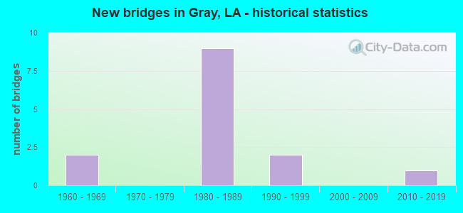
- New bridges - historical statistics
- 21960-1969
- 91980-1989
- 21990-1999
- 12010-2019


- Bridge Condition - Deck
- 45.5%Good
- 36.4%Satisfactory
- 18.2%Fair

- Bridge Condition - Superstructure
- 36.4%Good
- 45.5%Satisfactory
- 18.2%Fair

- Bridge Condition - Substructure
- 27.3%Good
- 18.2%Satisfactory
- 54.5%Fair

- Bridge Condition - Channel
- 10.0%Very good
- 80.0%Good
- 10.0%Satisfactory

- Bridge Condition - Culverts
- 66.7%Very good
- 33.3%Good
Find on map >> Show street view
Structure Number: 2550000002, Location: 2.0 MI S OF US 90 (Lat: 29.655419, Lng: -90.766489), Route carried "on" structure: State highway 660, Year Built: 2019, Status: Open, Structure Length: 0.91m (2.99ft), Average Daily Traffic: 7,300 (year 2018), Average Future Daily Traffic: 7,600 (year 2039), Design Load: Greater than HL93, Features Intersected: BAYOU TERREBONNE
Minimum Vertical Clearance: 30+ m (98+ ft), Kilometerpoint: 0.048, Lanes on structure: 2, Owner: State Highway Agency, Approaching Roadway Width: 9.6m (31.5ft), Material/Design: Steel, Design/Construction: Culvert, Number Of Spans In Main Unit: 3, Length of Maximum Span: 2.4m (7.9ft), Curb-To-Curb Width: 9.6m (31.5ft), Out-to-Out Width: 35.4m (116.1ft)
Condition: Channel: Good, Culverts: Very good, Operating Rating: 97.2 metric tons, Method Used To Determine Operating Rating: Load and Resistance Factor Rating (LRFR) rating reported by rating factor(RF) method using HL-93 loadings, Inventory Rating: 74.5 metric tons, Method Used To Determine Inventory Rating: Load and Resistance Factor Rating (LRFR) rating reported by rating factor(RF) method using HL-93 loadings, Structural Evaluation: Equal to present desirable criteria, Deck Geometry: High priority of corrective action, Waterway Adequacy: Equal to present desirable criteria, Approach Roadway Alignment: Equal to present desirable criteria, Designated Inspection Frequency: Every 24 months, Inspection Date: May 2020
Find on map >> Show street view
Structure Number: 2550000002042, Location: ONE MILE EAST OF LA 24 (Lat: 29.680531, Lng: -90.772900), Route carried "on" structure: US 90, Year Built: 1980, Status: Open, Structure Length: 1.16m (3.81ft), Average Daily Traffic: 22,800 (year 2016), Truck Traffic: 18%, Average Future Daily Traffic: 27,652 (year 2036), Design Load: HS 20, Features Intersected: DRAIN CANAL
Minimum Vertical Clearance: 30+ m (98+ ft), Kilometerpoint: 28.313, Lanes on structure: 4, Base Highway Network: Yes (Inventory Route: 424-07-1, Subroute: 10), Owner: State Highway Agency, Approaching Roadway Width: 12.2m (40.0ft), Skew: 30 degrees, Material/Design: Steel, Design/Construction: Culvert, Number Of Spans In Main Unit: 1, Length of Maximum Span: 11.6m (38.1ft), Curb-To-Curb Width: 2.4m (7.9ft), Out-to-Out Width: 73.8m (242.1ft)
Condition: Channel: Satisfactory, Culverts: Good, Operating Rating: 97.2 metric tons, Method Used To Determine Operating Rating: Load and Resistance Factor Rating (LRFR) rating reported by rating factor(RF) method using HL-93 loadings, Inventory Rating: 74.5 metric tons, Method Used To Determine Inventory Rating: Load and Resistance Factor Rating (LRFR) rating reported by rating factor(RF) method using HL-93 loadings, Structural Evaluation: Better than present minimum criteria, Deck Geometry: High priority of replacement, Waterway Adequacy: Better than present minimum criteria, Approach Roadway Alignment: Equal to present desirable criteria, Length Of Structure Improvement: 1.80m (5.91ft), Designated Inspection Frequency: Every 24 months, Inspection Date: May 2020, Bridge Improvement Cost: $153,000, Total Project Cost: $229,000 ( Estimate for 2016)
Find on map >> Show street view
Structure Number: 25500650405009, Location: 0.01 M W OF LA 659 (Lat: 29.718661, Lng: -90.797369), Route carried "on" structure: Ramp State highway 24, Year Built: 1990, Status: Open, Structure Length: 0.82m (2.69ft), Average Daily Traffic: 258 (year 2015), Average Future Daily Traffic: 319 (year 2036), Design Load: HS 20, Features Intersected: BAYOU TERREBONNE
Minimum Vertical Clearance: 30+ m (98+ ft), Kilometerpoint: 16.356, Lanes on structure: 2, Owner: State Highway Agency, Approaching Roadway Width: 13.7m (44.9ft), Material/Design: Steel, Design/Construction: Culvert, Number Of Spans In Main Unit: 3, Length of Maximum Span: 2.4m (7.9ft), Curb-To-Curb Width: 13.7m (44.9ft), Out-to-Out Width: 30.5m (100.1ft)
Condition: Channel: Very good, Culverts: Very good, Operating Rating: 97.2 metric tons, Method Used To Determine Operating Rating: Load and Resistance Factor Rating (LRFR) rating reported by rating factor(RF) method using HL-93 loadings, Inventory Rating: 74.5 metric tons, Method Used To Determine Inventory Rating: Load and Resistance Factor Rating (LRFR) rating reported by rating factor(RF) method using HL-93 loadings, Structural Evaluation: Equal to present desirable criteria, Deck Geometry: Superior to present desirable criteria, Waterway Adequacy: Equal to present desirable criteria, Approach Roadway Alignment: Equal to present desirable criteria, Designated Inspection Frequency: Every 24 months, Inspection Date: May 2020
Find on map >> Show street view
Structure Number: 25504240700051, Location: .05 MI EAST OF LA 662 (Lat: 29.667881, Lng: -91.047000), Route carried "on" structure: US 90, Year Built: 1998, Status: Open, Structure Length: 69.31m (227.40ft), Average Daily Traffic: 11,400 (year 2016), Truck Traffic: 18%, Average Future Daily Traffic: 16,591 (year 2036), Design Load: HS 20, Features Intersected: LA662, BAYOU L'OURSE
Minimum Vertical Clearance: 30+ m (98+ ft), Kilometerpoint: 0.024, Lanes on structure: 2, Lanes under structure: 4, Base Highway Network: Yes (Inventory Route: 424-07-1, Subroute: 10), Owner: State Highway Agency, Approaching Roadway Width: 12.2m (40.0ft), Skew: 14 degrees, Material/Design: Prestressed concrete, Design/Construction: Stringer/Multi-beam, Number Of Spans In Main Unit: 30, Length of Maximum Span: 25.3m (83.0ft), Curb-To-Curb Width: 12.3m (40.4ft), Out-to-Out Width: 13.1m (43.0ft)
Condition: Deck: Good, Superstructure: Good, Substructure: Satisfactory, Channel: Good, Operating Rating: 53.5 metric tons, Method Used To Determine Operating Rating: Load Factor (LF), Inventory Rating: 32.7 metric tons, Method Used To Determine Inventory Rating: Load Factor (LF), Structural Evaluation: Equal to present minimum criteria, Deck Geometry: Better than present minimum criteria, Underclear: Better than present minimum criteria, Waterway Adequacy: Equal to present desirable criteria, Approach Roadway Alignment: Equal to present desirable criteria, Designated Inspection Frequency: Every 24 months, Inspection Date: October 2021, Deck Structure Type: Concrete Cast-file-Place
Find on map >> Show street view
Structure Number: 25504240714861, Location: 0.18 MI W OF LA 311 (Lat: 29.681689, Lng: -90.814700), Route carried "on" structure: US 90, Year Built: 1987, Status: Open, Structure Length: 82.94m (272.11ft), Average Daily Traffic: 11,400 (year 2016), Truck Traffic: 18%, Average Future Daily Traffic: 16,591 (year 2036), Design Load: HS 20, Features Intersected: LITTLE B BLACK/LA 311/SP
Minimum Vertical Clearance: 30+ m (98+ ft), Kilometerpoint: 24.237, Lanes on structure: 2, Lanes under structure: 4, Base Highway Network: Yes (Inventory Route: 424-07-1, Subroute: 10), Owner: State Highway Agency, Approaching Roadway Width: 15.2m (49.9ft), Skew: 10 degrees, Material/Design: Prestressed concrete, Design/Construction: Stringer/Multi-beam, Number Of Spans In Main Unit: 35, Number Of Approach Spans: 10, Length of Maximum Span: 23.8m (78.1ft), Curb-To-Curb Width: 12.2m (40.0ft), Out-to-Out Width: 13.0m (42.7ft)
Condition: Deck: Good, Superstructure: Satisfactory, Substructure: Satisfactory, Operating Rating: 66.2 metric tons, Method Used To Determine Operating Rating: Load Factor (LF), Inventory Rating: 39.9 metric tons, Method Used To Determine Inventory Rating: Load Factor (LF), Structural Evaluation: Equal to present minimum criteria, Deck Geometry: Better than present minimum criteria, Underclear: Better than present minimum criteria, Approach Roadway Alignment: Equal to present desirable criteria, Designated Inspection Frequency: Every 24 months, Inspection Date: October 2021, Deck Structure Type: Concrete Cast-file-Place
Find on map >> Show street view
Structure Number: 25504240714862, Location: 0.18 MI W OF LA 311 (Lat: 29.680939, Lng: -90.806200), Route carried "on" structure: US 90, Year Built: 1987, Status: Open, Structure Length: 82.94m (272.11ft), Average Daily Traffic: 11,400 (year 2016), Truck Traffic: 18%, Average Future Daily Traffic: 16,591 (year 2036), Design Load: HS 20, Features Intersected: LITTLE B BLACK/LA 311/SP
Minimum Vertical Clearance: 30+ m (98+ ft), Kilometerpoint: 5.053, Lanes on structure: 2, Lanes under structure: 4, Base Highway Network: Yes (Inventory Route: 424-07-2, Subroute: 10), Owner: State Highway Agency, Approaching Roadway Width: 15.2m (49.9ft), Skew: 10 degrees, Material/Design: Prestressed concrete, Design/Construction: Stringer/Multi-beam, Number Of Spans In Main Unit: 35, Number Of Approach Spans: 10, Length of Maximum Span: 23.2m (76.1ft), Curb-To-Curb Width: 12.2m (40.0ft), Out-to-Out Width: 13.0m (42.7ft)
Condition: Deck: Good, Superstructure: Good, Substructure: Good, Operating Rating: 66.2 metric tons, Method Used To Determine Operating Rating: Load Factor (LF), Inventory Rating: 39.9 metric tons, Method Used To Determine Inventory Rating: Load Factor (LF), Structural Evaluation: Better than present minimum criteria, Deck Geometry: Better than present minimum criteria, Underclear: Equal to present minimum criteria, Approach Roadway Alignment: Equal to present desirable criteria, Designated Inspection Frequency: Every 24 months, Inspection Date: October 2021, Deck Structure Type: Concrete Cast-file-Place
Find on map >> Show street view
Structure Number: 25504240714905, Location: 0.14 MI W OF LA 311 (Lat: 29.680789, Lng: -90.814200), Route carried "on" structure: Ramp US 90, Year Built: 1987, Status: Open, Structure Length: 14.94m (49.02ft), Average Daily Traffic: 2,280 (year 2016), Truck Traffic: 18%, Average Future Daily Traffic: 2,765 (year 2036), Design Load: HS 20, Features Intersected: ONRAMP TO 90 FROM 311
Minimum Vertical Clearance: 30+ m (98+ ft), Kilometerpoint: 0.256, Lanes on structure: 1, Owner: State Highway Agency, Approaching Roadway Width: 9.1m (29.9ft), Material/Design: Prestressed concrete, Design/Construction: Stringer/Multi-beam, Number Of Spans In Main Unit: 8, Number Of Approach Spans: 4, Length of Maximum Span: 15.2m (49.9ft), Curb-To-Curb Width: 7.9m (25.9ft), Out-to-Out Width: 8.8m (28.9ft)
Condition: Deck: Good, Superstructure: Good, Substructure: Good, Operating Rating: 56.2 metric tons, Method Used To Determine Operating Rating: Load Factor (LF), Inventory Rating: 33.6 metric tons, Method Used To Determine Inventory Rating: Load Factor (LF), Structural Evaluation: Better than present minimum criteria, Deck Geometry: Equal to present desirable criteria, Approach Roadway Alignment: Equal to present minimum criteria, Designated Inspection Frequency: Every 24 months, Inspection Date: April 2021, Deck Structure Type: Concrete Cast-file-Place
Find on map >> Show street view
Structure Number: 25504240714928, Location: 0.12 MI W OF LA 311 (Lat: 29.681839, Lng: -90.812800), Route carried "on" structure: Ramp US 90, Year Built: 1987, Status: Open, Structure Length: 11.73m (38.48ft), Average Daily Traffic: 2,280 (year 2016), Truck Traffic: 18%, Average Future Daily Traffic: 2,765 (year 2036), Design Load: HS 20, Features Intersected: OFFRAMP FROM 90 TO 311
Minimum Vertical Clearance: 30+ m (98+ ft), Kilometerpoint: 0.177, Lanes on structure: 1, Owner: State Highway Agency, Approaching Roadway Width: 9.1m (29.9ft), Material/Design: Prestressed concrete, Design/Construction: Stringer/Multi-beam, Number Of Spans In Main Unit: 7, Number Of Approach Spans: 3, Length of Maximum Span: 15.2m (49.9ft), Curb-To-Curb Width: 7.9m (25.9ft), Out-to-Out Width: 8.8m (28.9ft)
Condition: Deck: Good, Superstructure: Good, Substructure: Good, Operating Rating: 56.2 metric tons, Method Used To Determine Operating Rating: Load Factor (LF), Inventory Rating: 33.6 metric tons, Method Used To Determine Inventory Rating: Load Factor (LF), Structural Evaluation: Better than present minimum criteria, Deck Geometry: Equal to present desirable criteria, Approach Roadway Alignment: Equal to present minimum criteria, Designated Inspection Frequency: Every 24 months, Inspection Date: April 2021, Deck Structure Type: Concrete Cast-file-Place
Find on map >> Show street view
Structure Number: 25504240715901, Location: 1.00 MI E OF LA 311 (Lat: 29.679681, Lng: -90.797600), Route carried "on" structure: US 90, Year Built: 1987, Status: Open, Structure Length: 3.81m (12.50ft), Average Daily Traffic: 11,400 (year 2016), Truck Traffic: 18%, Average Future Daily Traffic: 16,591 (year 2036), Design Load: HS 20, Features Intersected: DRAINAGE CANAL NO 1
Minimum Vertical Clearance: 30+ m (98+ ft), Kilometerpoint: 25.915, Lanes on structure: 2, Base Highway Network: Yes (Inventory Route: 424-07-1, Subroute: 10), Owner: State Highway Agency, Approaching Roadway Width: 15.2m (49.9ft), Skew: 12 degrees, Material/Design: Concrete, Design/Construction: Slab, Number Of Spans In Main Unit: 5, Length of Maximum Span: 7.6m (24.9ft), Curb-To-Curb Width: 12.2m (40.0ft), Out-to-Out Width: 13.0m (42.7ft)
Condition: Deck: Satisfactory, Superstructure: Satisfactory, Substructure: Fair, Channel: Good, Operating Rating: 72.6 metric tons, Method Used To Determine Operating Rating: Load Factor (LF), Inventory Rating: 43.5 metric tons, Method Used To Determine Inventory Rating: Load Factor (LF), Structural Evaluation: Somewhat better than minimum adequacy, Deck Geometry: Better than present minimum criteria, Waterway Adequacy: Equal to present desirable criteria, Approach Roadway Alignment: Equal to present desirable criteria, Designated Inspection Frequency: Every 24 months, Underwater Inspection Frequency: Every 60 months, Inspection Date: Febuary 2021, Underwater Inspection Date: May 2019, Deck Structure Type: Concrete Cast-file-Place
Find on map >> Show street view
Structure Number: 25504240715902, Location: 1.0 MI E OF LA 311 (Lat: 29.679869, Lng: -90.797200), Route carried "on" structure: US 90, Year Built: 1987, Status: Open, Structure Length: 3.81m (12.50ft), Average Daily Traffic: 11,400 (year 2016), Truck Traffic: 18%, Average Future Daily Traffic: 16,591 (year 2036), Design Load: HS 20, Features Intersected: DRAINAGE CANAL NO 1
Minimum Vertical Clearance: 30+ m (98+ ft), Kilometerpoint: 4.170, Lanes on structure: 2, Base Highway Network: Yes (Inventory Route: 424-07-2, Subroute: 10), Owner: State Highway Agency, Approaching Roadway Width: 15.2m (49.9ft), Skew: 12 degrees, Material/Design: Concrete, Design/Construction: Slab, Number Of Spans In Main Unit: 4, Length of Maximum Span: 7.6m (24.9ft), Curb-To-Curb Width: 12.2m (40.0ft), Out-to-Out Width: 13.0m (42.7ft)
Condition: Deck: Satisfactory, Superstructure: Satisfactory, Substructure: Fair, Channel: Good, Operating Rating: 72.6 metric tons, Method Used To Determine Operating Rating: Load Factor (LF), Inventory Rating: 43.5 metric tons, Method Used To Determine Inventory Rating: Load Factor (LF), Structural Evaluation: Somewhat better than minimum adequacy, Deck Geometry: Better than present minimum criteria, Waterway Adequacy: Equal to present desirable criteria, Approach Roadway Alignment: Equal to present desirable criteria, Designated Inspection Frequency: Every 24 months, Underwater Inspection Frequency: Every 60 months, Inspection Date: Febuary 2021, Underwater Inspection Date: May 2019, Deck Structure Type: Concrete Cast-file-Place
Find on map >> Show street view
Structure Number: 25504240716161, Location: 1.30 MI E OF LA 311 (Lat: 29.679169, Lng: -90.793200), Route carried "on" structure: US 90, Year Built: 1987, Status: Open, Structure Length: 3.05m (10.01ft), Average Daily Traffic: 11,400 (year 2016), Truck Traffic: 18%, Average Future Daily Traffic: 16,591 (year 2036), Design Load: HS 20, Features Intersected: DRAINAGE CANAL NO 2
Minimum Vertical Clearance: 30+ m (98+ ft), Kilometerpoint: 26.340, Lanes on structure: 2, Base Highway Network: Yes (Inventory Route: 424-07-1, Subroute: 10), Owner: State Highway Agency, Approaching Roadway Width: 15.2m (49.9ft), Skew: 12 degrees, Material/Design: Concrete, Design/Construction: Slab, Number Of Spans In Main Unit: 4, Length of Maximum Span: 7.6m (24.9ft), Curb-To-Curb Width: 12.2m (40.0ft), Out-to-Out Width: 13.0m (42.7ft)
Condition: Deck: Satisfactory, Superstructure: Satisfactory, Substructure: Fair, Channel: Good, Operating Rating: 72.6 metric tons, Method Used To Determine Operating Rating: Load Factor (LF), Inventory Rating: 43.5 metric tons, Method Used To Determine Inventory Rating: Load Factor (LF), Structural Evaluation: Somewhat better than minimum adequacy, Deck Geometry: Better than present minimum criteria, Waterway Adequacy: Meets minimum limits, Approach Roadway Alignment: Equal to present desirable criteria, Designated Inspection Frequency: Every 24 months, Inspection Date: Febuary 2021, Deck Structure Type: Concrete Cast-file-Place
Find on map >> Show street view
Structure Number: 25504240716162, Location: 1.30 MI E OF LA 311 (Lat: 29.679389, Lng: -90.793000), Route carried "on" structure: US 90, Year Built: 1987, Status: Open, Structure Length: 3.05m (10.01ft), Average Daily Traffic: 11,400 (year 2016), Truck Traffic: 18%, Average Future Daily Traffic: 16,591 (year 2036), Design Load: HS 20, Features Intersected: DRAINAGE CANAL NO 2
Minimum Vertical Clearance: 30+ m (98+ ft), Kilometerpoint: 3.763, Lanes on structure: 2, Base Highway Network: Yes (Inventory Route: 424-07-2, Subroute: 10), Owner: State Highway Agency, Approaching Roadway Width: 15.2m (49.9ft), Skew: 12 degrees, Material/Design: Concrete, Design/Construction: Slab, Number Of Spans In Main Unit: 4, Length of Maximum Span: 7.6m (24.9ft), Curb-To-Curb Width: 12.2m (40.0ft), Out-to-Out Width: 13.0m (42.7ft)
Condition: Deck: Satisfactory, Superstructure: Satisfactory, Substructure: Fair, Channel: Good, Operating Rating: 72.6 metric tons, Method Used To Determine Operating Rating: Load Factor (LF), Inventory Rating: 43.5 metric tons, Method Used To Determine Inventory Rating: Load Factor (LF), Structural Evaluation: Somewhat better than minimum adequacy, Deck Geometry: Better than present minimum criteria, Waterway Adequacy: Meets minimum limits, Approach Roadway Alignment: Equal to present desirable criteria, Designated Inspection Frequency: Every 24 months, Underwater Inspection Frequency: Every 60 months, Inspection Date: Febuary 2021, Underwater Inspection Date: September 2020, Deck Structure Type: Concrete Cast-file-Place
Find on map >> Show street view
Structure Number: 25529401904431, Location: 0080 LOG MI FROM INT (Lat: 29.669069, Lng: -90.738400), Route carried "on" structure: County highway , Year Built: 1967, Status: Posted for load, Structure Length: 2.32m (7.61ft), Average Daily Traffic: 730 (year 1978), Average Future Daily Traffic: 905 (year 2036), Design Load: HS 20, Features Intersected: ST LOUIS BAYOU, Facility Carried by Structure: COUNTRY ESTATES DR
Minimum Vertical Clearance: 30+ m (98+ ft), Kilometerpoint: 0.000, Lanes on structure: 2, Owner: County Highway Agency, Approaching Roadway Width: 9.1m (29.9ft), Skew: 3 degrees, Material/Design: Concrete, Design/Construction: Slab, Number Of Spans In Main Unit: 4, Length of Maximum Span: 5.8m (19.0ft), Curb-To-Curb Width: 7.6m (24.9ft), Out-to-Out Width: 8.0m (26.2ft)
Condition: Deck: Fair, Superstructure: Fair, Substructure: Fair, Channel: Good, Operating Rating: 23.3 metric tons, Method Used To Determine Operating Rating: Load and Resistance Factor Rating (LRFR) rating reported by rating factor(RF) method using HL-93 loadings, Inventory Rating: 18.1 metric tons, Method Used To Determine Inventory Rating: Load and Resistance Factor Rating (LRFR) rating reported by rating factor(RF) method using HL-93 loadings, Structural Evaluation: Somewhat better than minimum adequacy, Deck Geometry: Meets minimum limits, Waterway Adequacy: Better than present minimum criteria, Approach Roadway Alignment: Equal to present desirable criteria, Bridge Posting: Required (Relationship of Operating Rating to Maximum Legal Load: 0.1 - 9.9% below), Length Of Structure Improvement: 3.08m (10.10ft), Designated Inspection Frequency: Every 24 months, Underwater Inspection Frequency: Every 60 months, Inspection Date: May 2021, Underwater Inspection Date: September 2020, Bridge Improvement Cost: $183,000, Total Project Cost: $274,000 ( Estimate for 2016), Deck Structure Type: Concrete Precast Panels, Wearing Surface/Protective System: Wearing Surface: Bituminous
Find on map >> Show street view
Structure Number: 25529405904671, Location: 0003 LOG MI FROM IN (Lat: 29.675000, Lng: -90.778300), Route carried "on" structure: County highway , Year Built: 1963, Status: Posted for load, Structure Length: 2.32m (7.61ft), Average Daily Traffic: 2,000 (year 1978), Average Future Daily Traffic: 2,480 (year 2036), Design Load: HS 20, Features Intersected: TERREBONNE BAYOU, Facility Carried by Structure: RESERVATION BR
Minimum Vertical Clearance: 30+ m (98+ ft), Kilometerpoint: 0.000, Lanes on structure: 2, Owner: County Highway Agency, Approaching Roadway Width: 10.4m (34.1ft), Material/Design: Concrete, Design/Construction: Slab, Number Of Spans In Main Unit: 4, Length of Maximum Span: 5.8m (19.0ft), Curb-To-Curb Width: 7.4m (24.3ft), Out-to-Out Width: 8.0m (26.2ft)
Condition: Deck: Fair, Superstructure: Fair, Substructure: Fair, Channel: Good, Operating Rating: 23.0 metric tons, Method Used To Determine Operating Rating: Load and Resistance Factor Rating (LRFR) rating reported by rating factor(RF) method using HL-93 loadings, Inventory Rating: 17.8 metric tons, Method Used To Determine Inventory Rating: Load and Resistance Factor Rating (LRFR) rating reported by rating factor(RF) method using HL-93 loadings, Structural Evaluation: Meets minimum limits, Deck Geometry: Meets minimum limits, Waterway Adequacy: Better than present minimum criteria, Approach Roadway Alignment: Equal to present desirable criteria, Bridge Posting: Required (Relationship of Operating Rating to Maximum Legal Load: 0.1 - 9.9% below), Length Of Structure Improvement: 3.08m (10.10ft), Designated Inspection Frequency: Every 24 months, Inspection Date: May 2021, Bridge Improvement Cost: $183,000, Total Project Cost: $274,000 ( Estimate for 2016), Deck Structure Type: Concrete Precast Panels, Wearing Surface/Protective System: Wearing Surface: Monolithic Concrete
Find on map >> Show street view
Structure Number: 25504240714861, Location: 4.2 miles S of LA 20 (Lat: 29.681400, Lng: -90.811850), Route carried "under" structure: State highway 311, Structure Length: 0. m, Average Daily Traffic: 2,100 (year 2014), Features Intersected: LA 311 SB under US 90 EB
Minimum Vertical Clearance: 7.04m (23.10ft), Kilometerpoint: 5.868, Lanes on structure: 2, Lanes under structure: 2, Length of Maximum Span: 0.0m
Find on map >> Show street view
Structure Number: 25504240714861, Location: 4.2 miles S of LA 20 (Lat: 29.681231, Lng: -90.811711), Route carried "under" structure: State highway 311, Structure Length: 0. m, Average Daily Traffic: 2,100 (year 2014), Features Intersected: LA 311 NB under US 90 EB
Minimum Vertical Clearance: 7.04m (23.10ft), Kilometerpoint: 4.701, Lanes on structure: 2, Lanes under structure: 2, Length of Maximum Span: 0.0m
Find on map >> Show street view
Structure Number: 25504240714862, Location: 4.2 miles S of LA 20 (Lat: 29.681511, Lng: -90.811631), Route carried "under" structure: State highway 311, Structure Length: 0. m, Average Daily Traffic: 2,100 (year 2014), Features Intersected: LA 311 NB under US 90 WB
Minimum Vertical Clearance: 7.04m (23.10ft), Kilometerpoint: 4.733, Lanes on structure: 2, Lanes under structure: 2, Length of Maximum Span: 0.0m
Find on map >> Show street view
Structure Number: 25504240714862, Location: 4.2 miles S of LA 20 (Lat: 29.681700, Lng: -90.811769), Route carried "under" structure: State highway 311, Structure Length: 0. m, Average Daily Traffic: 2,100 (year 2014), Features Intersected: LA 311 SB under US 90 WB
Minimum Vertical Clearance: 7.04m (23.10ft), Kilometerpoint: 5.832, Lanes on structure: 2, Lanes under structure: 2, Length of Maximum Span: 0.0m
Find on map >> Show street view
Structure Number: 25504240716541, Location: 1.2 miles S of LA 316 (Lat: 29.679569, Lng: -90.783989), Route carried "under" structure: State highway 24, Structure Length: 0. m, Average Daily Traffic: 13,500 (year 2014), Features Intersected: LA 24 SB under US 90 EB
Minimum Vertical Clearance: 5.46m (17.91ft), Kilometerpoint: 11.600, Lanes on structure: 2, Lanes under structure: 2, Length of Maximum Span: 0.0m
Find on map >> Show street view
Structure Number: 25504240716541, Location: 1.2 miles S of LA 316 (Lat: 29.679561, Lng: -90.782769), Route carried "under" structure: State highway 24, Structure Length: 0. m, Average Daily Traffic: 13,500 (year 2014), Features Intersected: LA 24 NB under US 90 EB
Minimum Vertical Clearance: 5.46m (17.91ft), Kilometerpoint: 11.758, Lanes on structure: 2, Lanes under structure: 2, Length of Maximum Span: 0.0m
Find on map >> Show street view
Structure Number: 25504240716542, Location: 1.2 miles S of LA 316 (Lat: 29.679800, Lng: -90.782919), Route carried "under" structure: State highway 24, Structure Length: 0. m, Average Daily Traffic: 13,500 (year 2014), Features Intersected: LA 24 NB under US 90 WB
Minimum Vertical Clearance: 5.58m (18.31ft), Kilometerpoint: 11.787, Lanes on structure: 2, Lanes under structure: 2, Length of Maximum Span: 0.0m
Find on map >> Show street view
Structure Number: 25504240716542, Location: 1.2 miles S of LA 316 (Lat: 29.679811, Lng: -90.784111), Route carried "under" structure: State highway 24, Structure Length: 0. m, Average Daily Traffic: 13,500 (year 2014), Features Intersected: LA 24 SB under US 90 WB
Minimum Vertical Clearance: 5.21m (17.09ft), Kilometerpoint: 11.571, Lanes on structure: 2, Lanes under structure: 2, Length of Maximum Span: 0.0m