Bridge Statistics for Granville, West Virginia (WV)
Condition, Traffic, Stress, Structural Evaluation, Project Costs
- National Bridge Inventory (NBI) Statistics
- 19Number of bridges
- 135ft / 41.1mTotal length
- $8,300,000Total costs
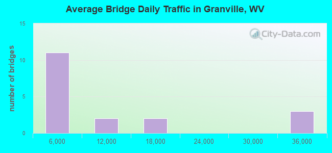
- 178,750Total average daily traffic
- 18,364Total average daily truck traffic
- National Bridge Inventory (NBI) Registered Bridges for Granville
- No street view available for this location
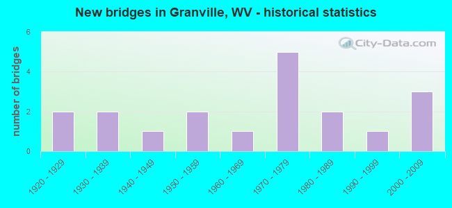
- New bridges - historical statistics
- 21920-1929
- 21930-1939
- 11940-1949
- 21950-1959
- 11960-1969
- 51970-1979
- 21980-1989
- 11990-1999
- 32000-2009
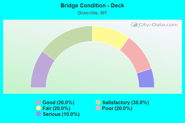
- Bridge Condition - Deck
- 20.0%Good
- 30.0%Satisfactory
- 20.0%Fair
- 20.0%Poor
- 10.0%Serious
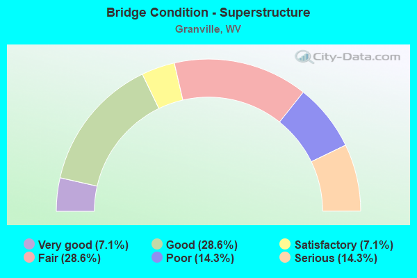
- Bridge Condition - Superstructure
- 7.1%Very good
- 28.6%Good
- 7.1%Satisfactory
- 28.6%Fair
- 14.3%Poor
- 14.3%Serious
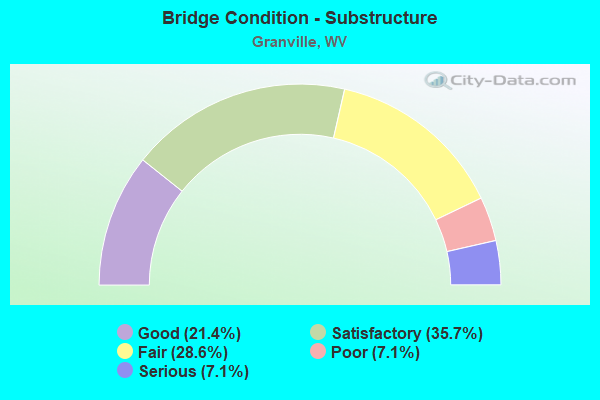
- Bridge Condition - Substructure
- 21.4%Good
- 35.7%Satisfactory
- 28.6%Fair
- 7.1%Poor
- 7.1%Serious
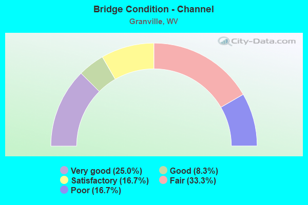
- Bridge Condition - Channel
- 25.0%Very good
- 8.3%Good
- 16.7%Satisfactory
- 33.3%Fair
- 16.7%Poor
Find on map >> Show street view
Structure Number: 31A048, Location: 0.03 MI SOUTH CO RT 46/2 (Lat: 39.618439, Lng: -80.020389), Route carried "on" structure: US 1900, Year Built: 1922, Status: Posted for load, Structure Length: 1.40m (4.59ft), Average Daily Traffic: 3,900 (year 2019), Truck Traffic: 6%, Average Future Daily Traffic: 4,900 (year 2041), Features Intersected: DENTS RUN, Facility Carried by Structure: U.S. RT. 19
Minimum Vertical Clearance: 30+ m (98+ ft), Kilometerpoint: 10.879, Lanes on structure: 2, Owner: State Highway Agency, Approaching Roadway Width: 7.9m (25.9ft), Skew: 3 degrees, Material/Design: Concrete, Design/Construction: Tee Beam, Number Of Spans In Main Unit: 1, Length of Maximum Span: 12.6m (41.3ft), Curb or Sidewalk Widths: Left: 0.2m (0.7ft), Right: 0.2m (0.7ft), Curb-To-Curb Width: 10.5m (34.4ft), Out-to-Out Width: 11.1m (36.4ft)
Condition: Deck: Fair, Superstructure: Poor, Substructure: Fair, Channel: Satisfactory, Operating Rating: 41.7 metric tons, Method Used To Determine Operating Rating: Field evaluation and documented engineering judgment, Inventory Rating: 17.2 metric tons, Method Used To Determine Inventory Rating: Field evaluation and documented engineering judgment, Structural Evaluation: Meets minimum limits, Deck Geometry: Somewhat better than minimum adequacy, Waterway Adequacy: Equal to present minimum criteria, Approach Roadway Alignment: Equal to present minimum criteria, Length Of Structure Improvement: 2.07m (6.79ft), Designated Inspection Frequency: Every 24 months, Inspection Date: March 2021, Bridge Improvement Cost: $393,000, Roadway Improvement Cost: $338,000, Total Project Cost: $853,000 ( Estimate for 2019), Deck Structure Type: Concrete Cast-file-Place, Wearing Surface/Protective System: Wearing Surface: Bituminous
Find on map >> Show street view
Structure Number: 31A059, Location: 0.01 MI NORTH CO RT 50 (Lat: 39.667031, Lng: -80.018339), Route carried "on" structure: US 1900, Year Built: 1954, Status: Open, Structure Length: 1.00m (3.28ft), Average Daily Traffic: 10,900 (year 2019), Truck Traffic: 6%, Average Future Daily Traffic: 13,750 (year 2041), Features Intersected: WADES RUN, Facility Carried by Structure: US ROUTE 19
Minimum Vertical Clearance: 30+ m (98+ ft), Kilometerpoint: 25.589, Lanes on structure: 2, Base Highway Network: Yes, Owner: State Highway Agency, Approaching Roadway Width: 11.0m (36.1ft), Material/Design: Concrete, Design/Construction: Slab, Number Of Spans In Main Unit: 1, Length of Maximum Span: 9.1m (29.9ft), Curb-To-Curb Width: 11.2m (36.7ft), Out-to-Out Width: 11.7m (38.4ft)
Condition: Deck: Fair, Superstructure: Fair, Substructure: Fair, Channel: Satisfactory, Operating Rating: 53.5 metric tons, Method Used To Determine Operating Rating: Field evaluation and documented engineering judgment, Inventory Rating: 24.5 metric tons, Method Used To Determine Inventory Rating: Field evaluation and documented engineering judgment, Structural Evaluation: Somewhat better than minimum adequacy, Deck Geometry: Meets minimum limits, Waterway Adequacy: Equal to present minimum criteria, Approach Roadway Alignment: Equal to present desirable criteria, Designated Inspection Frequency: Every 24 months, Inspection Date: March 2021, Deck Structure Type: Concrete Cast-file-Place, Wearing Surface/Protective System: Wearing Surface: Bituminous
Find on map >> Show street view
Structure Number: 31A063, Location: 0.10 MI EAST US ROUTE 19 (Lat: 39.616289, Lng: -80.016319), Route carried "on" structure: County highway 1904, Year Built: 1978, Status: Posted for load, Structure Length: 0.98m (3.22ft), Features Intersected: DENTS RUN, Facility Carried by Structure: MONONGALIA CR 19/4
Minimum Vertical Clearance: 30+ m (98+ ft), Kilometerpoint: 0.161, Lanes on structure: 1, Owner: State Highway Agency, Approaching Roadway Width: 3.7m (12.1ft), Material/Design: Steel, Design/Construction: Stringer/Multi-beam, Number Of Spans In Main Unit: 1, Length of Maximum Span: 8.8m (28.9ft), Curb or Sidewalk Widths: Left: 0.1m (0.3ft), Right: 0.1m (0.3ft), Curb-To-Curb Width: 4.0m (13.1ft), Out-to-Out Width: 4.3m (14.1ft)
Condition: Deck: Serious, Superstructure: Serious, Substructure: Serious, Channel: Fair, Operating Rating: 22.7 metric tons, Method Used To Determine Operating Rating: Load Factor (LF), Inventory Rating: 13.6 metric tons, Method Used To Determine Inventory Rating: Load Factor (LF), Structural Evaluation: High priority of corrective action, Deck Geometry: Somewhat better than minimum adequacy, Waterway Adequacy: Equal to present minimum criteria, Approach Roadway Alignment: Meets minimum limits, Bridge Posting: Required (Relationship of Operating Rating to Maximum Legal Load: 30.0 - 39.9% below), Length Of Structure Improvement: 1.46m (4.79ft), Designated Inspection Frequency: Every 24 months, Inspection Date: March 2020, Bridge Improvement Cost: $168,000, Roadway Improvement Cost: $129,000, Total Project Cost: $391,000 ( Estimate for 2020), Deck Structure Type: Wood or Timber, Wearing Surface/Protective System: Wearing Surface: Wood or Timber
Find on map >> Show street view
Structure Number: 31A065, Location: 0.20 MI EAST CR 19/12 (Lat: 39.661031, Lng: -80.004839), Route carried "on" structure: County highway 1925, Year Built: 1930, Status: Posted for load, Structure Length: 1.54m (5.05ft), Average Daily Traffic: 600 (year 2019), Truck Traffic: 6%, Average Future Daily Traffic: 930 (year 2041), Features Intersected: SCOTTS RUN, Facility Carried by Structure: MON CO RT 19/25
Minimum Vertical Clearance: 30+ m (98+ ft), Kilometerpoint: 0.885, Lanes on structure: 2, Owner: State Highway Agency, Approaching Roadway Width: 7.9m (25.9ft), Material/Design: Concrete, Design/Construction: Tee Beam, Number Of Spans In Main Unit: 1, Length of Maximum Span: 14.5m (47.6ft), Curb-To-Curb Width: 5.4m (17.7ft), Out-to-Out Width: 6.3m (20.7ft)
Condition: Deck: Poor, Superstructure: Poor, Substructure: Fair, Channel: Fair, Operating Rating: 37.2 metric tons, Method Used To Determine Operating Rating: Field evaluation and documented engineering judgment, Inventory Rating: 15.4 metric tons, Method Used To Determine Inventory Rating: Field evaluation and documented engineering judgment, Structural Evaluation: Meets minimum limits, Deck Geometry: High priority of replacement, Waterway Adequacy: Somewhat better than minimum adequacy, Approach Roadway Alignment: Meets minimum limits, Bridge Posting: Required (Relationship of Operating Rating to Maximum Legal Load: 0.1 - 9.9% below), Length Of Structure Improvement: 2.19m (7.19ft), Designated Inspection Frequency: Every 24 months, Inspection Date: March 2021, Bridge Improvement Cost: $234,000, Roadway Improvement Cost: $257,000, Total Project Cost: $648,000 ( Estimate for 2021), Deck Structure Type: Concrete Cast-file-Place, Wearing Surface/Protective System: Wearing Surface: Bituminous
Find on map >> Show street view
Structure Number: 31A066, Location: 0.29 MI WEST CO RT 54/1 (Lat: 39.660989, Lng: -80.000931), Route carried "on" structure: County highway 1925, Year Built: 1925, Status: Posted for load, Structure Length: 2.09m (6.86ft), Average Daily Traffic: 600 (year 2019), Truck Traffic: 6%, Average Future Daily Traffic: 930 (year 2041), Features Intersected: SCOTTS RUN, Facility Carried by Structure: MONON CO RT 19/25
Minimum Vertical Clearance: 30+ m (98+ ft), Kilometerpoint: 1.255, Lanes on structure: 2, Owner: State Highway Agency, Approaching Roadway Width: 8.2m (26.9ft), Material/Design: Concrete, Design/Construction: Tee Beam, Number Of Spans In Main Unit: 2, Length of Maximum Span: 9.1m (29.9ft), Curb or Sidewalk Widths: Left: 0.1m (0.3ft), Right: 0.1m (0.3ft), Curb-To-Curb Width: 5.1m (16.7ft), Out-to-Out Width: 5.9m (19.4ft)
Condition: Deck: Poor, Superstructure: Serious, Substructure: Fair, Channel: Poor, Operating Rating: 22.7 metric tons, Method Used To Determine Operating Rating: Load Factor (LF), Inventory Rating: 13.6 metric tons, Method Used To Determine Inventory Rating: Load Factor (LF), Structural Evaluation: High priority of corrective action, Deck Geometry: High priority of replacement, Waterway Adequacy: Better than present minimum criteria, Approach Roadway Alignment: Meets minimum limits, Bridge Posting: Required (Relationship of Operating Rating to Maximum Legal Load: 20.0 - 29.9% below), Length Of Structure Improvement: 2.80m (9.19ft), Designated Inspection Frequency: Every 24 months, Other Special Inspection Frequency: Every 12 months, Inspection Date: December 2021, Other Special Inspection Date: December 2021, Bridge Improvement Cost: $664,000, Roadway Improvement Cost: $399,000, Total Project Cost: $1,151,000 ( Estimate for 2022), Deck Structure Type: Concrete Cast-file-Place, Wearing Surface/Protective System: Wearing Surface: Bituminous
Find on map >> Show street view
Structure Number: 31A07, Location: 0.02 MI SOUTH CO RT 19/25 (Lat: 39.658669, Lng: -80.008211), Route carried "on" structure: County highway 1926, Year Built: 1952, Status: Open, Structure Length: 1.75m (5.74ft), Average Daily Traffic: 100 (year 2018), Average Future Daily Traffic: 135 (year 2038), Features Intersected: SCOTTS RUN, Facility Carried by Structure: COUNTY ROUTE 19/26
Minimum Vertical Clearance: 30+ m (98+ ft), Kilometerpoint: 0.032, Lanes on structure: 2, Owner: State Highway Agency, Approaching Roadway Width: 12.2m (40.0ft), Material/Design: Concrete continuous, Design/Construction: Frame, Number Of Spans In Main Unit: 2, Length of Maximum Span: 8.1m (26.6ft), Curb or Sidewalk Widths: Left: 0.8m (2.6ft), Right: 0.8m (2.6ft), Curb-To-Curb Width: 7.3m (24.0ft), Out-to-Out Width: 9.5m (31.2ft)
Condition: Superstructure: Fair, Substructure: Satisfactory, Channel: Fair, Operating Rating: 53.5 metric tons, Method Used To Determine Operating Rating: Field evaluation and documented engineering judgment, Inventory Rating: 24.5 metric tons, Method Used To Determine Inventory Rating: Field evaluation and documented engineering judgment, Structural Evaluation: Somewhat better than minimum adequacy, Deck Geometry: Equal to present minimum criteria, Waterway Adequacy: Better than present minimum criteria, Approach Roadway Alignment: Equal to present desirable criteria, Length Of Structure Improvement: 1.74m (5.71ft), Designated Inspection Frequency: Every 24 months, Inspection Date: December 2020, Bridge Improvement Cost: $224,000, Roadway Improvement Cost: $106,000, Total Project Cost: $393,000 ( Estimate for 2021), Deck Structure Type: Concrete Cast-file-Place
Find on map >> Show street view
Structure Number: 31A099, Location: 0.04 MI NORTH US RT 19 (Lat: 39.619761, Lng: -80.030619), Route carried "on" structure: County highway 4300, Year Built: 1935, Status: Open, Structure Length: 1.01m (3.31ft), Average Daily Traffic: 3,300 (year 2018), Truck Traffic: 6%, Average Future Daily Traffic: 4,500 (year 2038), Features Intersected: DENTS RUN, Facility Carried by Structure: MON CO RT 43
Minimum Vertical Clearance: 30+ m (98+ ft), Kilometerpoint: 0.064, Lanes on structure: 2, Owner: State Highway Agency, Approaching Roadway Width: 6.1m (20.0ft), Material/Design: Concrete, Design/Construction: Tee Beam, Number Of Spans In Main Unit: 1, Length of Maximum Span: 9.2m (30.2ft), Curb or Sidewalk Widths: Left: 0.1m (0.3ft), Right: 0.1m (0.3ft), Curb-To-Curb Width: 5.5m (18.0ft), Out-to-Out Width: 6.3m (20.7ft)
Condition: Deck: Good, Superstructure: Satisfactory, Substructure: Satisfactory, Channel: Good, Operating Rating: 47.2 metric tons, Method Used To Determine Operating Rating: Field evaluation and documented engineering judgment, Inventory Rating: 21.8 metric tons, Method Used To Determine Inventory Rating: Field evaluation and documented engineering judgment, Structural Evaluation: Somewhat better than minimum adequacy, Deck Geometry: High priority of replacement, Waterway Adequacy: Better than present minimum criteria, Approach Roadway Alignment: Meets minimum limits, Length Of Structure Improvement: 1.07m (3.51ft), Designated Inspection Frequency: Every 24 months, Inspection Date: Febuary 2020, Bridge Improvement Cost: $192,000, Roadway Improvement Cost: $141,000, Total Project Cost: $488,000 ( Estimate for 2020), Deck Structure Type: Concrete Cast-file-Place, Wearing Surface/Protective System: Wearing Surface: Bituminous
Find on map >> Show street view
Structure Number: 31A129, Location: 0.12 MI NORTH US ROUTE 19 (Lat: 39.668100, Lng: -80.018200), Route carried "on" structure: County highway 5000, Year Built: 1991, Status: Open, Structure Length: 1.60m (5.25ft), Average Daily Traffic: 800 (year 2019), Truck Traffic: 6%, Average Future Daily Traffic: 1,240 (year 2041), Design Load: HS 25 or greater, Features Intersected: WADES RUN, Facility Carried by Structure: MONONGALIA CR 50
Minimum Vertical Clearance: 30+ m (98+ ft), Kilometerpoint: 0.193, Lanes on structure: 2, Owner: State Highway Agency, Approaching Roadway Width: 6.4m (21.0ft), Skew: 4 degrees, Material/Design: Prestressed concrete, Design/Construction: Box Beam or Girders - Multiple, Number Of Spans In Main Unit: 1, Length of Maximum Span: 14.6m (47.9ft), Curb-To-Curb Width: 6.1m (20.0ft), Out-to-Out Width: 6.4m (21.0ft)
Condition: Superstructure: Good, Substructure: Good, Channel: Poor, Operating Rating: 88.9 metric tons, Method Used To Determine Operating Rating: Load Factor (LF), Inventory Rating: 55.3 metric tons, Method Used To Determine Inventory Rating: Load Factor (LF), Structural Evaluation: Better than present minimum criteria, Deck Geometry: High priority of corrective action, Waterway Adequacy: Equal to present minimum criteria, Approach Roadway Alignment: Somewhat better than minimum adequacy, Length Of Structure Improvement: 2.29m (7.51ft), Designated Inspection Frequency: Every 24 months, Inspection Date: November 2021, Bridge Improvement Cost: $378,000, Roadway Improvement Cost: $264,000, Total Project Cost: $661,000 ( Estimate for 2022), Deck Structure Type: Other, Wearing Surface/Protective System: Wearing Surface: Bituminous, Deck Protection: Epoxy Coated Reinforcing
Find on map >> Show street view
Structure Number: 31A13, Location: 0.52 MI NORTH US ROUTE 19 (Lat: 39.673800, Lng: -80.019500), Route carried "on" structure: County highway 5000, Year Built: 1989, Status: Open, Structure Length: 0.86m (2.82ft), Average Daily Traffic: 800 (year 2019), Truck Traffic: 6%, Average Future Daily Traffic: 1,240 (year 2041), Design Load: HS 25 or greater, Features Intersected: WADES RUN, Facility Carried by Structure: MONONGALIA CR 50
Minimum Vertical Clearance: 30+ m (98+ ft), Kilometerpoint: 0.837, Lanes on structure: 2, Owner: State Highway Agency, Approaching Roadway Width: 5.8m (19.0ft), Skew: 3 degrees, Material/Design: Prestressed concrete, Design/Construction: Box Beam or Girders - Multiple, Number Of Spans In Main Unit: 1, Length of Maximum Span: 8.2m (26.9ft), Curb-To-Curb Width: 6.1m (20.0ft), Out-to-Out Width: 6.2m (20.3ft)
Condition: Superstructure: Very good, Substructure: Satisfactory, Channel: Fair, Operating Rating: 88.9 metric tons, Method Used To Determine Operating Rating: Load Factor (LF), Inventory Rating: 56.2 metric tons, Method Used To Determine Inventory Rating: Load Factor (LF), Structural Evaluation: Equal to present minimum criteria, Deck Geometry: High priority of corrective action, Waterway Adequacy: Somewhat better than minimum adequacy, Approach Roadway Alignment: Equal to present minimum criteria, Length Of Structure Improvement: 1.52m (4.99ft), Designated Inspection Frequency: Every 24 months, Inspection Date: October 2021, Bridge Improvement Cost: $298,000, Roadway Improvement Cost: $241,000, Total Project Cost: $553,000 ( Estimate for 2022), Deck Structure Type: Other, Wearing Surface/Protective System: Wearing Surface: Bituminous, Deck Protection: Epoxy Coated Reinforcing
Find on map >> Show street view
Structure Number: 31A173, Location: 0.60 mi N.of Mon Co 46/7 (Lat: 39.641861, Lng: -80.004250), Route carried "on" structure: Interstate 7900, Year Built: 1969, Status: Open, Structure Length: 0.64m (2.10ft), Average Daily Traffic: 35,600 (year 2019), Truck Traffic: 18%, Average Future Daily Traffic: 48,425 (year 2039), Design Load: HS 20, Features Intersected: MINE TRACK BED, Facility Carried by Structure: I-79 & Mon Co 46/3
Minimum Vertical Clearance: 30+ m (98+ ft), Kilometerpoint: 247.678, Lanes on structure: 7, Base Highway Network: Yes, Owner: State Highway Agency, Approaching Roadway Width: 56.4m (185.0ft), Material/Design: Concrete, Design/Construction: Culvert, Number Of Spans In Main Unit: 1, Length of Maximum Span: 6.4m (21.0ft), Curb or Sidewalk Widths: Left: 0.0m, Right: 1.5m (4.9ft)
Condition: Culverts: Good, Operating Rating: 71.7 metric tons, Method Used To Determine Operating Rating: Field evaluation and documented engineering judgment, Inventory Rating: 32.7 metric tons, Method Used To Determine Inventory Rating: Field evaluation and documented engineering judgment, Structural Evaluation: Better than present minimum criteria, Approach Roadway Alignment: Superior to present desirable criteria, Designated Inspection Frequency: Every 24 months, Inspection Date: March 2021
Find on map >> Show street view
Structure Number: 31A174, Location: 2.34 MI NORTH US RT 19 (Lat: 39.655000, Lng: -80.010500), Route carried "on" structure: Interstate 7900, Year Built: 1972, Status: Open, Structure Length: 5.70m (18.70ft), Average Daily Traffic: 17,800 (year 2019), Truck Traffic: 16%, Average Future Daily Traffic: 25,450 (year 2041), Design Load: HS 20, Features Intersected: Mon. Co. 19/24, Facility Carried by Structure: INTERSTATE 79 SB
Minimum Vertical Clearance: 30+ m (98+ ft), Kilometerpoint: 249.239, Lanes on structure: 3, Lanes under structure: 3, Base Highway Network: Yes, Owner: State Highway Agency, Approaching Roadway Width: 15.2m (49.9ft), Material/Design: Steel continuous, Design/Construction: Stringer/Multi-beam, Number Of Spans In Main Unit: 1, Number Of Approach Spans: 2, Length of Maximum Span: 26.8m (87.9ft), Curb-To-Curb Width: 16.6m (54.5ft), Out-to-Out Width: 17.8m (58.4ft)
Condition: Deck: Satisfactory, Superstructure: Fair, Substructure: Satisfactory, Operating Rating: 53.5 metric tons, Method Used To Determine Operating Rating: Load Factor (LF), Inventory Rating: 32.7 metric tons, Method Used To Determine Inventory Rating: Load Factor (LF), Structural Evaluation: Somewhat better than minimum adequacy, Deck Geometry: Equal to present minimum criteria, Underclear: Equal to present minimum criteria, Approach Roadway Alignment: Equal to present desirable criteria, Length Of Structure Improvement: 5.70m (18.70ft), Designated Inspection Frequency: Every 24 months, Other Special Inspection Frequency: Every 12 months, Inspection Date: August 2021, Other Special Inspection Date: August 2021, Bridge Improvement Cost: $1,217,000, Roadway Improvement Cost: $236,000, Total Project Cost: $1,675,000 ( Estimate for 2021), Deck Structure Type: Concrete Cast-file-Place, Wearing Surface/Protective System: Wearing Surface: Latex Concrete
Find on map >> Show street view
Structure Number: 31A189, Location: 0.05 MI SOUTH CO RT 49 (Lat: 39.642839, Lng: -79.983839), Route carried "on" structure: State highway 10000, Year Built: 1988, Status: Open, Structure Length: 3.88m (12.73ft), Average Daily Traffic: 4,300 (year 2019), Truck Traffic: 6%, Average Future Daily Traffic: 5,550 (year 2041), Design Load: HS 25 or greater, Features Intersected: DENTS RUN, Facility Carried by Structure: WV ROUTE 100
Minimum Vertical Clearance: 30+ m (98+ ft), Kilometerpoint: 1.561, Lanes on structure: 2, Owner: State Highway Agency, Approaching Roadway Width: 7.9m (25.9ft), Skew: 3 degrees, Material/Design: Steel continuous, Design/Construction: Stringer/Multi-beam, Number Of Spans In Main Unit: 2, Length of Maximum Span: 18.6m (61.0ft), Curb or Sidewalk Widths: Left: 1.5m (4.9ft), Right: 0.0m, Curb-To-Curb Width: 9.0m (29.5ft), Out-to-Out Width: 11.3m (37.1ft)
Condition: Deck: Satisfactory, Superstructure: Good, Substructure: Satisfactory, Channel: Very good, Operating Rating: 88.9 metric tons, Method Used To Determine Operating Rating: Load Factor (LF), Inventory Rating: 59.0 metric tons, Method Used To Determine Inventory Rating: Load Factor (LF), Structural Evaluation: Equal to present minimum criteria, Deck Geometry: Meets minimum limits, Waterway Adequacy: Equal to present minimum criteria, Approach Roadway Alignment: Better than present minimum criteria, Designated Inspection Frequency: Every 24 months, Inspection Date: March 2021, Deck Structure Type: Concrete Cast-file-Place, Wearing Surface/Protective System: Deck Protection: Epoxy Coated Reinforcing
Find on map >> Show street view
Structure Number: 31A219, Location: 2.34 MI NORTH US RT 19 (Lat: 39.654900, Lng: -80.010200), Route carried "on" structure: Interstate 7900, Year Built: 1972, Status: Open, Structure Length: 5.70m (18.70ft), Average Daily Traffic: 17,800 (year 2019), Truck Traffic: 16%, Average Future Daily Traffic: 25,455 (year 2041), Design Load: HS 20, Features Intersected: Mon. Co. 19/24, Facility Carried by Structure: INTERSTATE 79 NB
Minimum Vertical Clearance: 30+ m (98+ ft), Kilometerpoint: 249.239, Lanes on structure: 2, Lanes under structure: 3, Base Highway Network: Yes, Owner: State Highway Agency, Approaching Roadway Width: 11.6m (38.1ft), Material/Design: Steel continuous, Design/Construction: Stringer/Multi-beam, Number Of Spans In Main Unit: 1, Number Of Approach Spans: 2, Length of Maximum Span: 26.8m (87.9ft), Curb-To-Curb Width: 12.3m (40.4ft), Out-to-Out Width: 13.6m (44.6ft)
Condition: Deck: Satisfactory, Superstructure: Fair, Substructure: Poor, Operating Rating: 48.1 metric tons, Method Used To Determine Operating Rating: Load Factor (LF), Inventory Rating: 29.0 metric tons, Method Used To Determine Inventory Rating: Load Factor (LF), Structural Evaluation: Meets minimum limits, Deck Geometry: Better than present minimum criteria, Underclear: Meets minimum limits, Approach Roadway Alignment: Equal to present desirable criteria, Length Of Structure Improvement: 5.70m (18.70ft), Designated Inspection Frequency: Every 24 months, Other Special Inspection Frequency: Every 12 months, Inspection Date: August 2021, Other Special Inspection Date: August 2021, Bridge Improvement Cost: $811,000, Roadway Improvement Cost: $198,000, Total Project Cost: $1,487,000 ( Estimate for 2021), Deck Structure Type: Concrete Cast-file-Place, Wearing Surface/Protective System: Wearing Surface: Latex Concrete
Find on map >> Show street view
Structure Number: 31A303, Location: 0.01 MI WEST MGL CO 19/25 (Lat: 39.660189, Lng: -80.008919), Route carried "on" structure: County highway 1940, Year Built: 2007, Status: Open, Structure Length: 1.45m (4.76ft), Average Daily Traffic: 50 (year 2016), Average Future Daily Traffic: 75 (year 2036), Features Intersected: SCOTTS RUN, Facility Carried by Structure: MGL CO RT 19/40
Minimum Vertical Clearance: 30+ m (98+ ft), Kilometerpoint: 0.016, Lanes on structure: 2, Owner: State Highway Agency, Approaching Roadway Width: 5.8m (19.0ft), Material/Design: Prestressed concrete, Design/Construction: Box Beam or Girders - Multiple, Number Of Spans In Main Unit: 1, Length of Maximum Span: 13.4m (44.0ft), Curb-To-Curb Width: 7.4m (24.3ft), Out-to-Out Width: 7.4m (24.3ft)
Condition: Superstructure: Good, Substructure: Good, Channel: Very good, Operating Rating: 60.8 metric tons, Method Used To Determine Operating Rating: Load Factor (LF), Inventory Rating: 47.2 metric tons, Method Used To Determine Inventory Rating: Load Factor (LF), Structural Evaluation: Better than present minimum criteria, Deck Geometry: Equal to present minimum criteria, Waterway Adequacy: Somewhat better than minimum adequacy, Approach Roadway Alignment: Equal to present minimum criteria, Designated Inspection Frequency: Every 48 months, Inspection Date: March 2018, Deck Structure Type: Other, Wearing Surface/Protective System: Deck Protection: Epoxy Coated Reinforcing
Find on map >> Show street view
Structure Number: 31A304, Location: 0.03 MI SOUTH CO RT 19/12 (Lat: 39.660361, Lng: -80.004631), Route carried "on" structure: US 1900, Year Built: 2008, Status: Open, Structure Length: 11.52m (37.80ft), Average Daily Traffic: 10,800 (year 2018), Truck Traffic: 4%, Average Future Daily Traffic: 14,700 (year 2038), Design Load: HL 93, Features Intersected: US ROUTE 19, Facility Carried by Structure: US ROUTE 19
Minimum Vertical Clearance: 30+ m (98+ ft), Kilometerpoint: 24.108, Lanes on structure: 2, Lanes under structure: 2, Base Highway Network: Yes, Owner: State Highway Agency, Approaching Roadway Width: 10.7m (35.1ft), Material/Design: Prestressed concrete continuous, Design/Construction: Stringer/Multi-beam, Number Of Spans In Main Unit: 3, Length of Maximum Span: 38.3m (125.7ft), Curb or Sidewalk Widths: Left: 0.0m, Right: 1.5m (4.9ft), Curb-To-Curb Width: 11.0m (36.1ft), Out-to-Out Width: 13.6m (44.6ft)
Condition: Deck: Good, Superstructure: Good, Substructure: Good, Channel: Very good, Operating Rating: 32.7 metric tons, Method Used To Determine Operating Rating: Load and Resistance Factor (LRFR), Inventory Rating: 25.4 metric tons, Method Used To Determine Inventory Rating: Load and Resistance Factor (LRFR), Structural Evaluation: Equal to present minimum criteria, Deck Geometry: Meets minimum limits, Underclear: Meets minimum limits, Waterway Adequacy: Superior to present desirable criteria, Approach Roadway Alignment: Equal to present desirable criteria, Designated Inspection Frequency: Every 24 months, Inspection Date: May 2020, Deck Structure Type: Concrete Cast-file-Place, Wearing Surface/Protective System: Deck Protection: Epoxy Coated Reinforcing
Find on map >> Show street view
Structure Number: 31A174, Location: 2.34 MI NORTH US RT 19 (Lat: 39.655000, Lng: -80.010500), Route carried "under" structure: County highway 1924, Year Built: 1972, Structure Length: 0. m, Average Daily Traffic: 33,800 (year 0018), Truck Traffic: 6%, Features Intersected: Mon. Co. 19/24, Facility Carried by Structure: INTERSTATE 79 SB
Minimum Vertical Clearance: 6.05m (19.85ft), Kilometerpoint: 4.458, Lanes on structure: 3, Lanes under structure: 3, Length of Maximum Span: 26.8m (87.9ft)
Find on map >> Show street view
Structure Number: 31A184, Location: 0.49 MI NORTH CR 19/8 (Lat: 39.667561, Lng: -79.985700), Route carried "under" structure: State highway 10000, Year Built: 1946, Structure Length: 0. m, Average Daily Traffic: 3,200 (year 2019), Truck Traffic: 7%, Features Intersected: MINE CONVEYOR, Facility Carried by Structure: MINE CONVEYOR BELT
Minimum Vertical Clearance: 7.52m (24.67ft), Kilometerpoint: 2.494, Lanes under structure: 2, Length of Maximum Span: 21.3m (69.9ft)
Find on map >> Show street view
Structure Number: 31A219, Location: 2.34 MI NORTH US RT 19 (Lat: 39.654900, Lng: -80.010200), Route carried "under" structure: County highway 1924, Year Built: 1972, Structure Length: 0. m, Average Daily Traffic: 33,800 (year 0018), Truck Traffic: 6%, Features Intersected: Mon. Co. 19/24, Facility Carried by Structure: INTERSTATE 79 NB
Minimum Vertical Clearance: 4.78m (15.68ft), Kilometerpoint: 4.458, Lanes on structure: 2, Lanes under structure: 3, Length of Maximum Span: 26.8m (87.9ft)
Find on map >> Show street view
Structure Number: 31A304, Location: 0.03 MI SOUTH CO RT 19/12 (Lat: 39.660361, Lng: -80.004631), Route carried "under" structure: County highway 1925, Year Built: 2008, Structure Length: 0. m, Average Daily Traffic: 600 (year 0018), Truck Traffic: 6%, Features Intersected: US ROUTE 19, Facility Carried by Structure: US ROUTE 19
Minimum Vertical Clearance: 11.41m (37.43ft), Kilometerpoint: 0.821, Lanes on structure: 2, Lanes under structure: 2, Length of Maximum Span: 38.3m (125.7ft)