Bridge Statistics for Grant-Valkaria, Florida (FL)
Condition, Traffic, Stress, Structural Evaluation, Project Costs
- National Bridge Inventory (NBI) Statistics
- 22Number of bridges
- 443ft / 135mTotal length
- 515,194Total average daily traffic
- 76,977Total average daily truck traffic
- National Bridge Inventory (NBI) Registered Bridges for Grant-Valkaria
- No street view available for this location
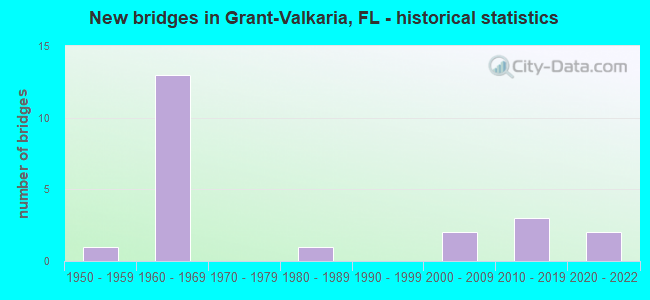
- New bridges - historical statistics
- 11950-1959
- 131960-1969
- 11980-1989
- 22000-2009
- 32010-2019
- 22020-2022


- Bridge Condition - Deck
- 28.6%Very good
- 71.4%Good

- Bridge Condition - Superstructure
- 28.6%Very good
- 71.4%Good

- Bridge Condition - Substructure
- 28.6%Very good
- 71.4%Good

- Bridge Condition - Channel
- 8.3%Very good
- 58.3%Good
- 25.0%Satisfactory
- 8.3%Fair

- Bridge Condition - Culverts
- 20.0%Very good
- 30.0%Good
- 50.0%Satisfactory
Find on map >> Show street view
Structure Number: 700003, Location: 3.4 Miles South of SR-514 (Lat: 27.960769, Lng: -80.540053), Route carried "on" structure: US 5, Year Built: 1964, Status: Open, Structure Length: 0.73m (2.40ft), Average Daily Traffic: 15,236 (year 2020), Truck Traffic: 7%, Average Future Daily Traffic: 26,434 (year 2042), Design Load: HS 20, Features Intersected: Kid Creek, Facility Carried by Structure: US-1
Minimum Vertical Clearance: 30+ m (98+ ft), Kilometerpoint: 12.918, Lanes on structure: 4, Base Highway Network: Yes, Owner: State Highway Agency, Approaching Roadway Width: 17.5m (57.4ft), Skew: 10 degrees, Material/Design: Concrete, Design/Construction: Culvert, Number Of Spans In Main Unit: 3, Length of Maximum Span: 2.1m (6.9ft)
Condition: Channel: Good, Culverts: Satisfactory, Operating Rating: 75.1 metric tons, Method Used To Determine Operating Rating: Load Factor (LF), Inventory Rating: 45.1 metric tons, Method Used To Determine Inventory Rating: Load Factor (LF), Structural Evaluation: Equal to present minimum criteria, Waterway Adequacy: Equal to present desirable criteria, Approach Roadway Alignment: Equal to present desirable criteria, Designated Inspection Frequency: Every 24 months, Underwater Inspection Frequency: Every 24 months, Inspection Date: April 2020, Underwater Inspection Date: April 2020
Find on map >> Show street view
Structure Number: 700093, Location: 2.3Mi N of Ind. River Co. (Lat: 27.848450, Lng: -80.578703), Route carried "on" structure: Interstate 95, Year Built: 1969, Year Reconstructed: 2012, Status: Open, Structure Length: 0.67m (2.20ft), Average Daily Traffic: 43,131 (year 2020), Truck Traffic: 18%, Average Future Daily Traffic: 74,832 (year 2042), Design Load: H 20, Features Intersected: Cattail Outfall
Minimum Vertical Clearance: 30+ m (98+ ft), Kilometerpoint: 3.644, Lanes on structure: 6, Base Highway Network: Yes, Owner: State Highway Agency, Approaching Roadway Width: 35.1m (115.2ft), Skew: 10 degrees, Material/Design: Concrete, Design/Construction: Culvert, Number Of Spans In Main Unit: 3, Length of Maximum Span: 2.1m (6.9ft)
Condition: Channel: Good, Culverts: Satisfactory, Inventory Rating: 86.0 metric tons, Method Used To Determine Inventory Rating: Load Factor (LF), Structural Evaluation: Equal to present minimum criteria, Waterway Adequacy: Equal to present desirable criteria, Approach Roadway Alignment: Equal to present desirable criteria, Designated Inspection Frequency: Every 24 months, Inspection Date: January 2021
Find on map >> Show street view
Structure Number: 700094, Location: 2.4Mi N of Ind. River Co. (Lat: 27.849428, Lng: -80.579561), Route carried "on" structure: Interstate 95, Year Built: 1969, Year Reconstructed: 2013, Status: Open, Structure Length: 0.67m (2.20ft), Average Daily Traffic: 43,131 (year 2020), Truck Traffic: 18%, Average Future Daily Traffic: 74,832 (year 2042), Design Load: HS 20, Features Intersected: Wishbone Canal
Minimum Vertical Clearance: 30+ m (98+ ft), Kilometerpoint: 3.779, Lanes on structure: 6, Base Highway Network: Yes, Owner: State Highway Agency, Approaching Roadway Width: 34.8m (114.2ft), Skew: 10 degrees, Material/Design: Concrete, Design/Construction: Culvert, Number Of Spans In Main Unit: 3, Length of Maximum Span: 2.1m (6.9ft)
Condition: Channel: Good, Culverts: Good, Inventory Rating: 86.0 metric tons, Method Used To Determine Inventory Rating: Load Factor (LF), Structural Evaluation: Better than present minimum criteria, Waterway Adequacy: Equal to present desirable criteria, Approach Roadway Alignment: Equal to present desirable criteria, Designated Inspection Frequency: Every 24 months, Inspection Date: January 2021
Find on map >> Show street view
Structure Number: 700095, Location: 0.5 Mi S of Micco Rd. (Lat: 27.866522, Lng: -80.591764), Route carried "on" structure: Interstate 95, Year Built: 1969, Status: Open, Structure Length: 0.86m (2.82ft), Average Daily Traffic: 43,131 (year 2020), Truck Traffic: 18%, Average Future Daily Traffic: 74,832 (year 2042), Design Load: H 20, Features Intersected: Sunshine Canal
Minimum Vertical Clearance: 30+ m (98+ ft), Kilometerpoint: 6.059, Lanes on structure: 6, Base Highway Network: Yes, Owner: State Highway Agency, Approaching Roadway Width: 40.0m (131.2ft), Skew: 30 degrees, Material/Design: Concrete, Design/Construction: Culvert, Number Of Spans In Main Unit: 3, Length of Maximum Span: 3.0m (9.8ft)
Condition: Channel: Satisfactory, Culverts: Satisfactory, Operating Rating: 53.4 metric tons, Method Used To Determine Operating Rating: Load Factor (LF), Inventory Rating: 32.0 metric tons, Method Used To Determine Inventory Rating: Load Factor (LF), Structural Evaluation: Equal to present minimum criteria, Waterway Adequacy: Equal to present desirable criteria, Approach Roadway Alignment: Equal to present desirable criteria, Designated Inspection Frequency: Every 24 months, Inspection Date: January 2021
Find on map >> Show street view
Structure Number: 700098, Location: 1.5 Mi S of Grant Rd. (Lat: 27.902764, Lng: -80.596653), Route carried "on" structure: Interstate 95, Year Built: 1969, Year Reconstructed: 2013, Status: Open, Structure Length: 0.67m (2.20ft), Average Daily Traffic: 43,131 (year 2020), Truck Traffic: 18%, Average Future Daily Traffic: 74,832 (year 2042), Design Load: HS 20, Features Intersected: Outfall
Minimum Vertical Clearance: 30+ m (98+ ft), Kilometerpoint: 10.140, Lanes on structure: 6, Base Highway Network: Yes, Owner: State Highway Agency, Approaching Roadway Width: 34.1m (111.9ft), Skew: 30 degrees, Material/Design: Concrete, Design/Construction: Culvert, Number Of Spans In Main Unit: 3, Length of Maximum Span: 2.1m (6.9ft)
Condition: Channel: Good, Culverts: Good, Operating Rating: 57.5 metric tons, Method Used To Determine Operating Rating: Load Factor (LF), Inventory Rating: 34.7 metric tons, Method Used To Determine Inventory Rating: Load Factor (LF), Structural Evaluation: Better than present minimum criteria, Waterway Adequacy: Equal to present desirable criteria, Approach Roadway Alignment: Equal to present desirable criteria, Designated Inspection Frequency: Every 24 months, Underwater Inspection Frequency: Every 24 months, Inspection Date: January 2021, Underwater Inspection Date: January 2021
Find on map >> Show street view
Structure Number: 7001, Location: 0.4 Mi S of Grant Rd. (Lat: 27.916858, Lng: -80.600250), Route carried "on" structure: Interstate 95, Year Built: 1969, Year Reconstructed: 2013, Status: Open, Structure Length: 0.76m (2.49ft), Average Daily Traffic: 43,131 (year 2020), Truck Traffic: 18%, Average Future Daily Traffic: 74,832 (year 2042), Design Load: HS 20, Features Intersected: Outfall
Minimum Vertical Clearance: 30+ m (98+ ft), Kilometerpoint: 11.743, Lanes on structure: 6, Base Highway Network: Yes, Owner: State Highway Agency, Approaching Roadway Width: 37.0m (121.4ft), Skew: 30 degrees, Material/Design: Concrete, Design/Construction: Culvert, Number Of Spans In Main Unit: 3, Length of Maximum Span: 2.4m (7.9ft)
Condition: Channel: Good, Culverts: Satisfactory, Structural Evaluation: Equal to present minimum criteria, Waterway Adequacy: Equal to present desirable criteria, Approach Roadway Alignment: Equal to present desirable criteria, Designated Inspection Frequency: Every 24 months, Underwater Inspection Frequency: Every 24 months, Inspection Date: January 2021, Underwater Inspection Date: January 2021
Find on map >> Show street view
Structure Number: 700155, Location: I-95 NB -Sottile Canal (Lat: 27.888350, Lng: -80.592825), Route carried "on" structure: Interstate 95, Year Built: 1969, Year Reconstructed: 2014, Status: Open, Structure Length: 3.96m (12.99ft), Average Daily Traffic: 21,566 (year 2020), Truck Traffic: 18%, Average Future Daily Traffic: 37,416 (year 2042), Design Load: HL 93, Features Intersected: Sottile Canal
Minimum Vertical Clearance: 30+ m (98+ ft), Kilometerpoint: 8.489, Lanes on structure: 3, Base Highway Network: Yes, Owner: State Highway Agency, Approaching Roadway Width: 17.1m (56.1ft), Skew: 1 degrees, Material/Design: Prestressed concrete, Design/Construction: Stringer/Multi-beam, Number Of Spans In Main Unit: 3, Length of Maximum Span: 13.3m (43.6ft), Curb-To-Curb Width: 17.1m (56.1ft), Out-to-Out Width: 18.0m (59.1ft)
Condition: Deck: Good, Superstructure: Good, Substructure: Good, Channel: Good, Operating Rating: 48.3 metric tons, Method Used To Determine Operating Rating: Load and Resistance Factor (LRFR), Inventory Rating: 41.8 metric tons, Method Used To Determine Inventory Rating: Load and Resistance Factor (LRFR), Structural Evaluation: Better than present minimum criteria, Deck Geometry: Equal to present minimum criteria, Waterway Adequacy: Equal to present desirable criteria, Approach Roadway Alignment: Equal to present desirable criteria, Designated Inspection Frequency: Every 24 months, Inspection Date: March 2021, Deck Structure Type: Concrete Cast-file-Place
Find on map >> Show street view
Structure Number: 700157, Location: 1.9MI E of Babcock St. (Lat: 27.873678, Lng: -80.591619), Route carried "on" structure: County highway , Year Built: 1969, Status: Open, Structure Length: 7.80m (25.59ft), Average Daily Traffic: 1,500 (year 2020), Truck Traffic: 5%, Average Future Daily Traffic: 2,602 (year 2042), Design Load: HS 20, Features Intersected: I-95, Facility Carried by Structure: Micco Rd.
Minimum Vertical Clearance: 30+ m (98+ ft), Kilometerpoint: 3.022, Lanes on structure: 2, Lanes under structure: 6, Owner: State Highway Agency, Approaching Roadway Width: 7.2m (23.6ft), Material/Design: Prestressed concrete, Design/Construction: Stringer/Multi-beam, Number Of Spans In Main Unit: 4, Length of Maximum Span: 26.8m (87.9ft), Curb-To-Curb Width: 12.2m (40.0ft), Out-to-Out Width: 12.9m (42.3ft)
Condition: Deck: Good, Superstructure: Good, Substructure: Good, Operating Rating: 50.9 metric tons, Method Used To Determine Operating Rating: Load Factor (LF), Inventory Rating: 32.4 metric tons, Method Used To Determine Inventory Rating: Load Factor (LF), Structural Evaluation: Better than present minimum criteria, Deck Geometry: Better than present minimum criteria, Underclear: Somewhat better than minimum adequacy, Approach Roadway Alignment: Equal to present desirable criteria, Designated Inspection Frequency: Every 24 months, Inspection Date: December 2020, Deck Structure Type: Concrete Cast-file-Place
Find on map >> Show street view
Structure Number: 700158, Location: 1.3 Mi. East of CR-507 (Lat: 27.924500, Lng: -80.602331), Route carried "on" structure: County highway , Year Built: 1969, Status: Open, Structure Length: 7.07m (23.20ft), Average Daily Traffic: 2,400 (year 2020), Truck Traffic: 5%, Average Future Daily Traffic: 4,164 (year 2042), Features Intersected: I-95, Facility Carried by Structure: Grant Rd.
Minimum Vertical Clearance: 30+ m (98+ ft), Kilometerpoint: 2.000, Lanes on structure: 2, Lanes under structure: 6, Owner: State Highway Agency, Approaching Roadway Width: 7.2m (23.6ft), Skew: 1 degrees, Material/Design: Prestressed concrete, Design/Construction: Stringer/Multi-beam, Number Of Spans In Main Unit: 4, Length of Maximum Span: 22.4m (73.5ft), Curb or Sidewalk Widths: Left: 0.5m (1.6ft), Right: 0.5m (1.6ft), Curb-To-Curb Width: 8.5m (27.9ft), Out-to-Out Width: 10.1m (33.1ft)
Condition: Deck: Good, Superstructure: Good, Substructure: Good, Operating Rating: 71.3 metric tons, Method Used To Determine Operating Rating: Load Factor (LF), Inventory Rating: 43.6 metric tons, Method Used To Determine Inventory Rating: Load Factor (LF), Structural Evaluation: Better than present minimum criteria, Deck Geometry: Meets minimum limits, Underclear: Somewhat better than minimum adequacy, Approach Roadway Alignment: Equal to present desirable criteria, Designated Inspection Frequency: Every 24 months, Inspection Date: December 2020, Roadway Improvement Cost: $700,201,000, Deck Structure Type: Concrete Cast-file-Place
Find on map >> Show street view
Structure Number: 700159, Location: Valkaria Road - I-95 (Lat: 27.953589, Lng: -80.609750), Route carried "on" structure: County highway , Year Built: 1969, Status: Open, Structure Length: 7.16m (23.49ft), Average Daily Traffic: 12,600 (year 2020), Truck Traffic: 5%, Average Future Daily Traffic: 21,861 (year 2042), Design Load: H 20, Features Intersected: I-95, Facility Carried by Structure: Valkaria Road
Minimum Vertical Clearance: 30+ m (98+ ft), Kilometerpoint: 1.233, Lanes on structure: 2, Lanes under structure: 6, Owner: State Highway Agency, Approaching Roadway Width: 7.3m (24.0ft), Skew: 1 degrees, Material/Design: Prestressed concrete, Design/Construction: Stringer/Multi-beam, Number Of Spans In Main Unit: 4, Length of Maximum Span: 22.5m (73.8ft), Curb or Sidewalk Widths: Left: 0.5m (1.6ft), Right: 0.5m (1.6ft), Curb-To-Curb Width: 8.5m (27.9ft), Out-to-Out Width: 10.1m (33.1ft)
Condition: Deck: Good, Superstructure: Good, Substructure: Good, Operating Rating: 71.3 metric tons, Method Used To Determine Operating Rating: Load Factor (LF), Inventory Rating: 43.5 metric tons, Method Used To Determine Inventory Rating: Load Factor (LF), Structural Evaluation: Better than present minimum criteria, Deck Geometry: Meets minimum limits, Underclear: Somewhat better than minimum adequacy, Approach Roadway Alignment: Equal to present desirable criteria, Designated Inspection Frequency: Every 24 months, Inspection Date: March 2021, Deck Structure Type: Concrete Cast-file-Place
Find on map >> Show street view
Structure Number: 700165, Location: 4.2 Mi N of Sebastian Ri (Lat: 27.910092, Lng: -80.516106), Route carried "on" structure: US 1, Year Built: 1959, Status: Open, Structure Length: 0.64m (2.10ft), Average Daily Traffic: 15,236 (year 2020), Truck Traffic: 7%, Average Future Daily Traffic: 26,434 (year 2042), Design Load: HS 20+Mod, Features Intersected: Canal
Minimum Vertical Clearance: 30+ m (98+ ft), Kilometerpoint: 6.769, Lanes on structure: 4, Base Highway Network: Yes, Owner: State Highway Agency, Approaching Roadway Width: 16.5m (54.1ft), Skew: 21 degrees, Material/Design: Concrete, Design/Construction: Culvert, Number Of Spans In Main Unit: 2, Length of Maximum Span: 3.0m (9.8ft)
Condition: Channel: Fair, Culverts: Satisfactory, Operating Rating: 58.0 metric tons, Method Used To Determine Operating Rating: Load Factor (LF), Inventory Rating: 34.8 metric tons, Method Used To Determine Inventory Rating: Load Factor (LF), Structural Evaluation: Equal to present minimum criteria, Waterway Adequacy: Equal to present desirable criteria, Approach Roadway Alignment: Equal to present desirable criteria, Designated Inspection Frequency: Every 24 months, Inspection Date: Febuary 2022
Find on map >> Show street view
Structure Number: 700223, Location: St.Johns Heritage Pkwy (Lat: 27.895639, Lng: -80.595028), Route carried "on" structure: County highway , Year Built: 2020, Status: Open, Structure Length: 89.76m (294.49ft), Average Daily Traffic: 25 (year 2020), Average Future Daily Traffic: 44 (year 2042), Design Load: HL 93, Features Intersected: I-95, Facility Carried by Structure: St Johns Heritage
Minimum Vertical Clearance: 5.09m (16.70ft), Kilometerpoint: 9.331, Lanes on structure: 4, Lanes under structure: 6, Owner: State Highway Agency, Approaching Roadway Width: 21.9m (71.9ft), Material/Design: Prestressed concrete, Design/Construction: Stringer/Multi-beam, Number Of Spans In Main Unit: 3, Length of Maximum Span: 313.9m (1,029.9ft), Curb or Sidewalk Widths: Left: 0.0m, Right: 3.7m (12.1ft), Curb-To-Curb Width: 21.9m (71.9ft), Out-to-Out Width: 43.8m (143.7ft)
Condition: Deck: Very good, Superstructure: Very good, Substructure: Very good, Operating Rating: 56.5 metric tons, Method Used To Determine Operating Rating: Load and Resistance Factor (LRFR), Inventory Rating: 35.3 metric tons, Method Used To Determine Inventory Rating: Load and Resistance Factor (LRFR), Structural Evaluation: Equal to present desirable criteria, Deck Geometry: Superior to present desirable criteria, Underclear: Equal to present minimum criteria, Approach Roadway Alignment: Equal to present desirable criteria, Designated Inspection Frequency: Every 24 months, Inspection Date: August 2020, Deck Structure Type: Concrete Cast-file-Place, Wearing Surface/Protective System: Wearing Surface: Monolithic Concrete
Find on map >> Show street view
Structure Number: 700242, Location: I-95 NB Off Ramp to SJP (Lat: 27.893142, Lng: -80.593414), Route carried "on" structure: Ramp State highway 95, Year Built: 2019, Status: Open, Structure Length: 0.74m (2.43ft), Average Daily Traffic: 800 (year 2020), Truck Traffic: 5%, Average Future Daily Traffic: 1,388 (year 2042), Design Load: HL 93, Features Intersected: Outfall Ditch
Minimum Vertical Clearance: 30.45m (99.90ft), Kilometerpoint: 0.000, Lanes on structure: 1, Owner: State Highway Agency, Approaching Roadway Width: 6.4m (21.0ft), Material/Design: Concrete, Design/Construction: Culvert, Number Of Spans In Main Unit: 3, Length of Maximum Span: 2.3m (7.5ft)
Condition: Channel: Very good, Culverts: Very good, Operating Rating: 57.5 metric tons, Method Used To Determine Operating Rating: Load and Resistance Factor (LRFR), Inventory Rating: 44.5 metric tons, Method Used To Determine Inventory Rating: Load and Resistance Factor (LRFR), Structural Evaluation: Equal to present desirable criteria, Waterway Adequacy: Better than present minimum criteria, Approach Roadway Alignment: Equal to present desirable criteria, Designated Inspection Frequency: Every 24 months, Inspection Date: September 2021
Find on map >> Show street view
Structure Number: 704095, Location: 2.5 Miles West of US-1 (Lat: 27.953592, Lng: -80.573992), Route carried "on" structure: County highway , Year Built: 2003, Status: Open, Structure Length: 0.79m (2.59ft), Average Daily Traffic: 3,200 (year 2020), Truck Traffic: 4%, Average Future Daily Traffic: 5,552 (year 2042), Features Intersected: Goat Creek, Facility Carried by Structure: Valkaria Road
Minimum Vertical Clearance: 30+ m (98+ ft), Kilometerpoint: 4.781, Lanes on structure: 2, Owner: Town or Township Highway Agency, Maintenance Responsibility: County Highway Agency, Approaching Roadway Width: 7.0m (23.0ft), Material/Design: Concrete, Design/Construction: Culvert, Number Of Spans In Main Unit: 2, Length of Maximum Span: 3.7m (12.1ft)
Condition: Channel: Satisfactory, Culverts: Very good, Operating Rating: 56.5 metric tons, Method Used To Determine Operating Rating: Load Factor (LF), Inventory Rating: 33.9 metric tons, Method Used To Determine Inventory Rating: Load Factor (LF), Structural Evaluation: Equal to present desirable criteria, Waterway Adequacy: Equal to present minimum criteria, Approach Roadway Alignment: Equal to present desirable criteria, Designated Inspection Frequency: Every 24 months, Inspection Date: Febuary 2022
Find on map >> Show street view
Structure Number: 704096, Location: 0.2Mi. W of Valkaria Rd. (Lat: 27.965008, Lng: -80.568092), Route carried "on" structure: County highway , Year Built: 2007, Status: Open, Structure Length: 0.75m (2.46ft), Average Daily Traffic: 54 (year 2021), Truck Traffic: 5%, Average Future Daily Traffic: 63 (year 2042), Design Load: HL 93, Features Intersected: Goat Creek, Facility Carried by Structure: Gradick Drive
Minimum Vertical Clearance: 30+ m (98+ ft), Kilometerpoint: 0.542, Lanes on structure: 2, Owner: Town or Township Highway Agency, Maintenance Responsibility: County Highway Agency, Approaching Roadway Width: 6.1m (20.0ft), Skew: 3 degrees, Material/Design: Concrete, Design/Construction: Culvert, Number Of Spans In Main Unit: 2, Length of Maximum Span: 3.7m (12.1ft)
Condition: Channel: Satisfactory, Culverts: Good, Operating Rating: 50.3 metric tons, Method Used To Determine Operating Rating: Load and Resistance Factor (LRFR), Inventory Rating: 38.8 metric tons, Method Used To Determine Inventory Rating: Load and Resistance Factor (LRFR), Structural Evaluation: Better than present minimum criteria, Waterway Adequacy: Equal to present desirable criteria, Approach Roadway Alignment: Equal to present desirable criteria, Designated Inspection Frequency: Every 24 months, Inspection Date: March 2021
Find on map >> Show street view
Structure Number: 704191, Location: 0.25 mi N of Valkaria Rd (Lat: 27.966725, Lng: -80.547456), Route carried "on" structure: County highway , Year Built: 1987, Status: Open, Structure Length: 2.38m (7.81ft), Average Daily Traffic: 274 (year 2020), Truck Traffic: 32%, Average Future Daily Traffic: 476 (year 2042), Design Load: HS 20, Features Intersected: Goat Creek, Facility Carried by Structure: Tadlock Ave.
Minimum Vertical Clearance: 30+ m (98+ ft), Kilometerpoint: 0.016, Lanes on structure: 2, Owner: Town or Township Highway Agency, Maintenance Responsibility: County Highway Agency, Approaching Roadway Width: 9.1m (29.9ft), Material/Design: Concrete continuous, Design/Construction: Slab, Number Of Spans In Main Unit: 3, Length of Maximum Span: 7.9m (25.9ft), Curb-To-Curb Width: 11.0m (36.1ft), Out-to-Out Width: 11.8m (38.7ft)
Condition: Deck: Good, Superstructure: Good, Substructure: Good, Channel: Good, Operating Rating: 66.2 metric tons, Method Used To Determine Operating Rating: Load Factor (LF), Inventory Rating: 39.7 metric tons, Method Used To Determine Inventory Rating: Load Factor (LF), Structural Evaluation: Better than present minimum criteria, Deck Geometry: Equal to present desirable criteria, Waterway Adequacy: Better than present minimum criteria, Approach Roadway Alignment: Equal to present desirable criteria, Designated Inspection Frequency: Every 24 months, Underwater Inspection Frequency: Every 24 months, Inspection Date: Febuary 2022, Underwater Inspection Date: Febuary 2022, Deck Structure Type: Concrete Cast-file-Place
Find on map >> Show street view
Structure Number: 704199, Location: 0.5 M N of Sottile Canal (Lat: 27.895472, Lng: -80.594917), Route carried "on" structure: County highway , Year Built: 2019, Status: Open, Structure Length: 10.05m (32.97ft), Average Daily Traffic: 25 (year 2020), Average Future Daily Traffic: 44 (year 2042), Design Load: HL 93, Features Intersected: I-95, Facility Carried by Structure: St.Johns Heritage
Minimum Vertical Clearance: 5.43m (17.81ft), Kilometerpoint: 9.308, Lanes on structure: 3, Lanes under structure: 6, Owner: State Highway Agency, Approaching Roadway Width: 13.9m (45.6ft), Skew: 10 degrees, Material/Design: Prestressed concrete, Design/Construction: Stringer/Multi-beam, Number Of Spans In Main Unit: 3, Length of Maximum Span: 34.7m (113.8ft), Curb-To-Curb Width: 13.9m (45.6ft), Out-to-Out Width: 14.8m (48.6ft)
Condition: Deck: Very good, Superstructure: Very good, Substructure: Very good, Operating Rating: 58.8 metric tons, Method Used To Determine Operating Rating: Load and Resistance Factor (LRFR), Inventory Rating: 43.5 metric tons, Method Used To Determine Inventory Rating: Load and Resistance Factor (LRFR), Structural Evaluation: Equal to present desirable criteria, Deck Geometry: Meets minimum limits, Underclear: Better than present minimum criteria, Approach Roadway Alignment: Better than present minimum criteria, Designated Inspection Frequency: Every 24 months, Inspection Date: August 2020, Deck Structure Type: Concrete Cast-file-Place, Wearing Surface/Protective System: Wearing Surface: Monolithic Concrete
Find on map >> Show street view
Structure Number: 700157, Location: 1.9MI E of Babcock St. (Lat: 27.873678, Lng: -80.591619), Route carried "under" structure: Interstate 95, Year Built: 1969, Structure Length: 0. m, Average Daily Traffic: 43,131 (year 2020), Truck Traffic: 18%, Features Intersected: I-95, Facility Carried by Structure: Micco Rd.
Minimum Vertical Clearance: 5.00m (16.40ft), Kilometerpoint: 6.857, Lanes on structure: 2, Lanes under structure: 6, Material/Design: Prestressed concrete, Design/Construction: Stringer/Multi-beam, Length of Maximum Span: 26.8m (87.9ft)
Find on map >> Show street view
Structure Number: 700158, Location: 1.3 Mi. East of CR-507 (Lat: 27.924500, Lng: -80.602331), Route carried "under" structure: Interstate 95, Year Built: 1969, Structure Length: 0. m, Average Daily Traffic: 43,131 (year 2020), Truck Traffic: 18%, Features Intersected: I-95, Facility Carried by Structure: Grant Rd.
Minimum Vertical Clearance: 4.94m (16.21ft), Kilometerpoint: 12.609, Lanes on structure: 2, Lanes under structure: 6, Material/Design: Prestressed concrete, Design/Construction: Stringer/Multi-beam, Length of Maximum Span: 22.4m (73.5ft)
Find on map >> Show street view
Structure Number: 700159, Location: Valkaria Road - I-95 (Lat: 27.953589, Lng: -80.609750), Route carried "under" structure: Interstate 95, Year Built: 1969, Structure Length: 0. m, Average Daily Traffic: 43,131 (year 2020), Truck Traffic: 18%, Features Intersected: I-95, Facility Carried by Structure: Valkaria Road
Minimum Vertical Clearance: 4.91m (16.11ft), Kilometerpoint: 15.987, Lanes on structure: 2, Lanes under structure: 6, Material/Design: Prestressed concrete, Design/Construction: Stringer/Multi-beam, Length of Maximum Span: 22.5m (73.8ft)
Find on map >> Show street view
Structure Number: 700223, Location: St.Johns Heritage Pkwy (Lat: 27.895639, Lng: -80.595028), Route carried "under" structure: Interstate 95, Year Built: 2020, Structure Length: 0. m, Average Daily Traffic: 48,615 (year 2019), Truck Traffic: 16%, Features Intersected: I-95, Facility Carried by Structure: St Johns Heritage
Minimum Vertical Clearance: 5.15m (16.90ft), Kilometerpoint: 8.489, Lanes on structure: 4, Lanes under structure: 6, Toll: On toll road, Material/Design: Prestressed concrete, Design/Construction: Stringer/Multi-beam, Length of Maximum Span: 313.9m (1,029.9ft)
Find on map >> Show street view
Structure Number: 704199, Location: 0.5 M N of Sottile Canal (Lat: 27.895472, Lng: -80.594917), Route carried "under" structure: Interstate 95, Year Built: 2019, Structure Length: 0. m, Average Daily Traffic: 48,615 (year 2019), Features Intersected: I-95, Facility Carried by Structure: St.Johns Heritage
Minimum Vertical Clearance: 5.43m (17.81ft), Kilometerpoint: 9.334, Lanes on structure: 3, Lanes under structure: 6, Material/Design: Prestressed concrete, Design/Construction: Stringer/Multi-beam, Length of Maximum Span: 34.7m (113.8ft)