Bridge Statistics for Grand Ridge, Florida (FL)
Condition, Traffic, Stress, Structural Evaluation, Project Costs
- National Bridge Inventory (NBI) Statistics
- 17Number of bridges
- 121ft / 37.2mTotal length
- 115,247Total average daily traffic
- 36,308Total average daily truck traffic
- National Bridge Inventory (NBI) Registered Bridges for Grand Ridge
- No street view available for this location
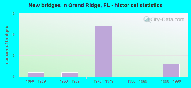
- New bridges - historical statistics
- 11950-1959
- 11960-1969
- 121970-1979
- 31990-1999


- Bridge Condition - Deck
- 14.3%Good
- 85.7%Satisfactory

- Bridge Condition - Superstructure
- 42.9%Good
- 57.1%Satisfactory

- Bridge Condition - Substructure
- 71.4%Good
- 14.3%Fair
- 14.3%Poor

- Bridge Condition - Channel
- 44.4%Good
- 33.3%Satisfactory
- 22.2%Fair

- Bridge Condition - Culverts
- 16.7%Good
- 66.7%Satisfactory
- 16.7%Fair
Find on map >> Show street view
Structure Number: 530038, Location: 1.0mi. East of SR69 (Lat: 30.718856, Lng: -85.003411), Route carried "on" structure: US 90, Year Built: 1967, Status: Open, Structure Length: 0.95m (3.12ft), Average Daily Traffic: 6,700 (year 2020), Truck Traffic: 9%, Average Future Daily Traffic: 11,624 (year 2042), Design Load: HS 20+Mod, Features Intersected: Ditch
Minimum Vertical Clearance: 30+ m (98+ ft), Kilometerpoint: 23.373, Lanes on structure: 4, Base Highway Network: Yes, Owner: State Highway Agency, Approaching Roadway Width: 17.7m (58.1ft), Skew: 10 degrees, Material/Design: Concrete, Design/Construction: Culvert, Number Of Spans In Main Unit: 3, Length of Maximum Span: 3.0m (9.8ft)
Condition: Channel: Good, Culverts: Good, Operating Rating: 52.6 metric tons, Method Used To Determine Operating Rating: Load Factor (LF), Inventory Rating: 31.8 metric tons, Method Used To Determine Inventory Rating: Load Factor (LF), Structural Evaluation: Better than present minimum criteria, Waterway Adequacy: Better than present minimum criteria, Approach Roadway Alignment: Equal to present desirable criteria, Designated Inspection Frequency: Every 24 months, Inspection Date: June 2021
Find on map >> Show street view
Structure Number: 53006, Location: 10.0 Mi. East of SR71 (Lat: 30.657231, Lng: -85.038017), Route carried "on" structure: Interstate 10, Year Built: 1976, Status: Open, Structure Length: 6.94m (22.77ft), Average Daily Traffic: 10,200 (year 2020), Truck Traffic: 34%, Average Future Daily Traffic: 17,697 (year 2042), Design Load: HS 20, Features Intersected: SR69
Minimum Vertical Clearance: 30+ m (98+ ft), Kilometerpoint: 40.594, Lanes on structure: 2, Lanes under structure: 2, Base Highway Network: Yes, Owner: State Highway Agency, Approaching Roadway Width: 11.6m (38.1ft), Skew: 3 degrees, Material/Design: Prestressed concrete, Design/Construction: Stringer/Multi-beam, Number Of Spans In Main Unit: 4, Length of Maximum Span: 22.9m (75.1ft), Curb-To-Curb Width: 12.2m (40.0ft), Out-to-Out Width: 13.1m (43.0ft)
Condition: Deck: Satisfactory, Superstructure: Satisfactory, Substructure: Good, Operating Rating: 69.1 metric tons, Method Used To Determine Operating Rating: Load Factor (LF), Inventory Rating: 41.5 metric tons, Method Used To Determine Inventory Rating: Load Factor (LF), Structural Evaluation: Equal to present minimum criteria, Deck Geometry: Better than present minimum criteria, Underclear: Equal to present minimum criteria, Approach Roadway Alignment: Equal to present desirable criteria, Designated Inspection Frequency: Every 24 months, Inspection Date: September 2021, Deck Structure Type: Concrete Cast-file-Place
Find on map >> Show street view
Structure Number: 530061, Location: 10.0 Mi. East of SR71 (Lat: 30.656964, Lng: -85.038053), Route carried "on" structure: Interstate 10, Year Built: 1976, Status: Open, Structure Length: 6.94m (22.77ft), Average Daily Traffic: 10,200 (year 2020), Truck Traffic: 34%, Average Future Daily Traffic: 17,697 (year 2042), Design Load: HS 20, Features Intersected: SR69
Minimum Vertical Clearance: 30+ m (98+ ft), Kilometerpoint: 40.594, Lanes on structure: 2, Lanes under structure: 2, Base Highway Network: Yes, Owner: State Highway Agency, Approaching Roadway Width: 11.6m (38.1ft), Skew: 3 degrees, Material/Design: Prestressed concrete, Design/Construction: Stringer/Multi-beam, Number Of Spans In Main Unit: 4, Length of Maximum Span: 22.9m (75.1ft), Curb-To-Curb Width: 12.2m (40.0ft), Out-to-Out Width: 13.1m (43.0ft)
Condition: Deck: Satisfactory, Superstructure: Satisfactory, Substructure: Good, Operating Rating: 76.2 metric tons, Method Used To Determine Operating Rating: Load Factor (LF), Inventory Rating: 45.4 metric tons, Method Used To Determine Inventory Rating: Load Factor (LF), Structural Evaluation: Equal to present minimum criteria, Deck Geometry: Better than present minimum criteria, Underclear: Equal to present minimum criteria, Approach Roadway Alignment: Equal to present desirable criteria, Designated Inspection Frequency: Every 24 months, Inspection Date: September 2021, Deck Structure Type: Concrete Cast-file-Place
Find on map >> Show street view
Structure Number: 530062, Location: 1.7mi. East of SR69 (Lat: 30.648422, Lng: -85.012444), Route carried "on" structure: County highway 69A, Year Built: 1976, Status: Open, Structure Length: 7.36m (24.15ft), Average Daily Traffic: 600 (year 2020), Truck Traffic: 17%, Average Future Daily Traffic: 1,041 (year 2042), Design Load: HS 20+Mod, Features Intersected: I10 SR8
Minimum Vertical Clearance: 30+ m (98+ ft), Kilometerpoint: 2.926, Lanes on structure: 2, Lanes under structure: 4, Owner: State Highway Agency, Approaching Roadway Width: 7.3m (24.0ft), Material/Design: Prestressed concrete, Design/Construction: Stringer/Multi-beam, Number Of Spans In Main Unit: 4, Length of Maximum Span: 27.5m (90.2ft), Curb-To-Curb Width: 9.8m (32.2ft), Out-to-Out Width: 10.5m (34.4ft)
Condition: Deck: Satisfactory, Superstructure: Good, Substructure: Good, Operating Rating: 49.9 metric tons, Method Used To Determine Operating Rating: Load Factor (LF), Inventory Rating: 29.9 metric tons, Method Used To Determine Inventory Rating: Load Factor (LF), Structural Evaluation: Better than present minimum criteria, Deck Geometry: Equal to present minimum criteria, Underclear: Meets minimum limits, Approach Roadway Alignment: Equal to present desirable criteria, Designated Inspection Frequency: Every 24 months, Inspection Date: June 2021, Deck Structure Type: Concrete Cast-file-Place
Find on map >> Show street view
Structure Number: 530064, Location: 7.0 Mi East of SR71 (Lat: 30.677019, Lng: -85.079558), Route carried "on" structure: County highway 275, Year Built: 1976, Status: Open, Structure Length: 8.20m (26.90ft), Average Daily Traffic: 1,250 (year 2020), Truck Traffic: 20%, Average Future Daily Traffic: 2,169 (year 2042), Design Load: HS 20+Mod, Features Intersected: I10 SR8
Minimum Vertical Clearance: 30+ m (98+ ft), Kilometerpoint: 5.224, Lanes on structure: 2, Lanes under structure: 4, Owner: State Highway Agency, Approaching Roadway Width: 6.1m (20.0ft), Skew: 2 degrees, Material/Design: Prestressed concrete, Design/Construction: Stringer/Multi-beam, Number Of Spans In Main Unit: 4, Length of Maximum Span: 29.2m (95.8ft), Curb-To-Curb Width: 9.8m (32.2ft), Out-to-Out Width: 10.5m (34.4ft)
Condition: Deck: Good, Superstructure: Good, Substructure: Good, Operating Rating: 59.9 metric tons, Method Used To Determine Operating Rating: Load Factor (LF), Inventory Rating: 36.3 metric tons, Method Used To Determine Inventory Rating: Load Factor (LF), Structural Evaluation: Better than present minimum criteria, Deck Geometry: Somewhat better than minimum adequacy, Underclear: Somewhat better than minimum adequacy, Approach Roadway Alignment: Equal to present desirable criteria, Designated Inspection Frequency: Every 24 months, Inspection Date: September 2021, Deck Structure Type: Concrete Cast-file-Place
Find on map >> Show street view
Structure Number: 530075, Location: 0.9mi. East of SR69 (Lat: 30.650194, Lng: -85.025056), Route carried "on" structure: Interstate 10, Year Built: 1976, Status: Open, Structure Length: 0.69m (2.26ft), Average Daily Traffic: 10,200 (year 2020), Truck Traffic: 34%, Average Future Daily Traffic: 17,697 (year 2042), Design Load: HS 20, Features Intersected: Dickson Bay Creek
Minimum Vertical Clearance: 30+ m (98+ ft), Kilometerpoint: 42.023, Lanes on structure: 2, Base Highway Network: Yes, Owner: State Highway Agency, Approaching Roadway Width: 11.6m (38.1ft), Material/Design: Concrete, Design/Construction: Culvert, Number Of Spans In Main Unit: 3, Length of Maximum Span: 2.1m (6.9ft)
Condition: Channel: Satisfactory, Culverts: Satisfactory, Structural Evaluation: Equal to present minimum criteria, Waterway Adequacy: Better than present minimum criteria, Approach Roadway Alignment: Equal to present desirable criteria, Designated Inspection Frequency: Every 24 months, Inspection Date: March 2021
Find on map >> Show street view
Structure Number: 530076, Location: 0.9mi. East of SR69 (Lat: 30.652222, Lng: -85.025417), Route carried "on" structure: Interstate 10, Year Built: 1976, Status: Open, Structure Length: 0.69m (2.26ft), Average Daily Traffic: 10,200 (year 2020), Truck Traffic: 34%, Average Future Daily Traffic: 17,697 (year 2042), Design Load: HS 20, Features Intersected: Dickson Bay Creek
Minimum Vertical Clearance: 30+ m (98+ ft), Kilometerpoint: 42.044, Lanes on structure: 2, Base Highway Network: Yes, Owner: State Highway Agency, Approaching Roadway Width: 11.6m (38.1ft), Material/Design: Concrete, Design/Construction: Culvert, Number Of Spans In Main Unit: 3, Length of Maximum Span: 2.1m (6.9ft)
Condition: Channel: Good, Culverts: Satisfactory, Structural Evaluation: Equal to present minimum criteria, Waterway Adequacy: Better than present minimum criteria, Approach Roadway Alignment: Equal to present desirable criteria, Designated Inspection Frequency: Every 24 months, Inspection Date: March 2021
Find on map >> Show street view
Structure Number: 530077, Location: 1.0mi. East of SR69 (Lat: 30.650389, Lng: -85.023333), Route carried "on" structure: Interstate 10, Year Built: 1976, Status: Open, Structure Length: 0.69m (2.26ft), Average Daily Traffic: 10,200 (year 2020), Truck Traffic: 34%, Average Future Daily Traffic: 17,697 (year 2042), Design Load: HS 20, Features Intersected: Dickson Bay Creek
Minimum Vertical Clearance: 30+ m (98+ ft), Kilometerpoint: 42.174, Lanes on structure: 2, Base Highway Network: Yes, Owner: State Highway Agency, Approaching Roadway Width: 11.6m (38.1ft), Material/Design: Concrete, Design/Construction: Culvert, Number Of Spans In Main Unit: 3, Length of Maximum Span: 2.1m (6.9ft)
Condition: Channel: Good, Culverts: Satisfactory, Inventory Rating: 70.9 metric tons, Method Used To Determine Inventory Rating: Load Factor (LF), Structural Evaluation: Equal to present minimum criteria, Waterway Adequacy: Equal to present desirable criteria, Approach Roadway Alignment: Equal to present desirable criteria, Designated Inspection Frequency: Every 24 months, Inspection Date: March 2021
Find on map >> Show street view
Structure Number: 530078, Location: 1.0mi. East of SR69 (Lat: 30.651861, Lng: -85.022722), Route carried "on" structure: Interstate 10, Year Built: 1976, Status: Open, Structure Length: 0.69m (2.26ft), Average Daily Traffic: 10,200 (year 2020), Truck Traffic: 34%, Average Future Daily Traffic: 17,697 (year 2042), Design Load: HS 20, Features Intersected: Dickson Bay Creek
Minimum Vertical Clearance: 30+ m (98+ ft), Kilometerpoint: 42.316, Lanes on structure: 2, Base Highway Network: Yes, Owner: State Highway Agency, Approaching Roadway Width: 11.6m (38.1ft), Material/Design: Concrete, Design/Construction: Culvert, Number Of Spans In Main Unit: 3, Length of Maximum Span: 2.1m (6.9ft)
Condition: Channel: Good, Culverts: Satisfactory, Operating Rating: 85.9 metric tons, Method Used To Determine Operating Rating: Load Factor (LF), Inventory Rating: 51.5 metric tons, Method Used To Determine Inventory Rating: Load Factor (LF), Structural Evaluation: Equal to present minimum criteria, Waterway Adequacy: Equal to present desirable criteria, Approach Roadway Alignment: Equal to present desirable criteria, Designated Inspection Frequency: Every 24 months, Inspection Date: March 2021
Find on map >> Show street view
Structure Number: 534005, Location: 0.6 Miles West of SR 69 (Lat: 30.619839, Lng: -85.038886), Route carried "on" structure: Other road , Year Built: 1991, Status: Posted for load, Structure Length: 1.48m (4.86ft), Average Daily Traffic: 39 (year 2020), Average Future Daily Traffic: 43 (year 2040), Design Load: HL 93, Features Intersected: Carpenter Sink Creek, Facility Carried by Structure: Bradley Road
Minimum Vertical Clearance: 30+ m (98+ ft), Kilometerpoint: 3.252, Lanes on structure: 1, Owner: County Highway Agency, Approaching Roadway Width: 3.7m (12.1ft), Material/Design: Wood or Timber, Design/Construction: Stringer/Multi-beam, Number Of Spans In Main Unit: 4, Length of Maximum Span: 3.9m (12.8ft), Curb or Sidewalk Widths: Left: 0.1m (0.3ft), Right: 0.1m (0.3ft), Curb-To-Curb Width: 5.8m (19.0ft), Out-to-Out Width: 6.1m (20.0ft)
Condition: Deck: Satisfactory, Superstructure: Satisfactory, Substructure: Poor, Channel: Satisfactory, Operating Rating: 7.3 metric tons, Method Used To Determine Operating Rating: Load and Resistance Factor (LRFR), Inventory Rating: 5.4 metric tons, Method Used To Determine Inventory Rating: Load and Resistance Factor (LRFR), Structural Evaluation: High priority of corrective action, Deck Geometry: Meets minimum limits, Waterway Adequacy: Better than present minimum criteria, Approach Roadway Alignment: Equal to present desirable criteria, Bridge Posting: Required (Relationship of Operating Rating to Maximum Legal Load: > 39.9% below), Designated Inspection Frequency: Every 24 months, Underwater Inspection Frequency: Every 12 months, Other Special Inspection Frequency: Every 12 months, Inspection Date: November 2020, Underwater Inspection Date: November 2021, Other Special Inspection Date: November 2021, Deck Structure Type: Wood or Timber, Wearing Surface/Protective System: Wearing Surface: Wood or Timber
Find on map >> Show street view
Structure Number: 534024, Location: 0.5 Mi S of Raylene Road (Lat: 30.620836, Lng: -85.053189), Route carried "on" structure: Other road , Year Built: 1992, Status: Posted for load, Structure Length: 1.16m (3.81ft), Average Daily Traffic: 42 (year 2019), Average Future Daily Traffic: 46 (year 2039), Design Load: HL 93, Features Intersected: Carpenter Sink Creek, Facility Carried by Structure: Braswell Road
Minimum Vertical Clearance: 30+ m (98+ ft), Kilometerpoint: 0.779, Lanes on structure: 1, Owner: County Highway Agency, Approaching Roadway Width: 5.5m (18.0ft), Material/Design: Wood or Timber, Design/Construction: Stringer/Multi-beam, Number Of Spans In Main Unit: 3, Length of Maximum Span: 4.4m (14.4ft), Curb or Sidewalk Widths: Left: 0.2m (0.7ft), Right: 0.2m (0.7ft), Curb-To-Curb Width: 5.8m (19.0ft), Out-to-Out Width: 6.2m (20.3ft)
Condition: Deck: Satisfactory, Superstructure: Satisfactory, Substructure: Fair, Channel: Satisfactory, Operating Rating: 21.8 metric tons, Method Used To Determine Operating Rating: Load and Resistance Factor (LRFR), Inventory Rating: 16.3 metric tons, Method Used To Determine Inventory Rating: Load and Resistance Factor (LRFR), Structural Evaluation: Somewhat better than minimum adequacy, Deck Geometry: Meets minimum limits, Waterway Adequacy: Better than present minimum criteria, Approach Roadway Alignment: Equal to present desirable criteria, Bridge Posting: Required (Relationship of Operating Rating to Maximum Legal Load: 10.0 - 19.9% below), Designated Inspection Frequency: Every 24 months, Other Special Inspection Frequency: Every 12 months, Inspection Date: April 2020, Other Special Inspection Date: April 2021, Deck Structure Type: Wood or Timber, Wearing Surface/Protective System: Wearing Surface: Wood or Timber
Find on map >> Show street view
Structure Number: 5341, Location: 0.14 Miles S of Gilley Rd (Lat: 30.764417, Lng: -84.979333), Route carried "on" structure: County highway 69A, Year Built: 1957, Status: Open, Structure Length: 0.63m (2.07ft), Average Daily Traffic: 150 (year 2019), Truck Traffic: 1%, Average Future Daily Traffic: 165 (year 2039), Design Load: HS 20, Features Intersected: Race Pond Branch, Facility Carried by Structure: Salem Church Road
Minimum Vertical Clearance: 30+ m (98+ ft), Kilometerpoint: 2.261, Lanes on structure: 2, Owner: County Highway Agency, Approaching Roadway Width: 6.0m (19.7ft), Material/Design: Concrete, Design/Construction: Culvert, Number Of Spans In Main Unit: 2, Length of Maximum Span: 3.1m (10.2ft)
Condition: Channel: Fair, Culverts: Fair, Inventory Rating: 61.7 metric tons, Method Used To Determine Inventory Rating: Load Factor (LF), Structural Evaluation: Somewhat better than minimum adequacy, Waterway Adequacy: Better than present minimum criteria, Approach Roadway Alignment: Equal to present minimum criteria, Designated Inspection Frequency: Every 24 months, Inspection Date: October 2020
Find on map >> Show street view
Structure Number: 534155, Location: 0.44 Mi S Birchwood Road (Lat: 30.626022, Lng: -85.063261), Route carried "on" structure: Other road , Year Built: 1994, Status: Open, Structure Length: 0.74m (2.43ft), Average Daily Traffic: 66 (year 2020), Average Future Daily Traffic: 73 (year 2040), Design Load: HL 93, Features Intersected: Carpenters Sink Creek, Facility Carried by Structure: Reno Road
Minimum Vertical Clearance: 30+ m (98+ ft), Kilometerpoint: 0.914, Lanes on structure: 1, Owner: County Highway Agency, Approaching Roadway Width: 4.3m (14.1ft), Material/Design: Wood or Timber, Design/Construction: Stringer/Multi-beam, Number Of Spans In Main Unit: 2, Length of Maximum Span: 3.7m (12.1ft), Curb or Sidewalk Widths: Left: 0.2m (0.7ft), Right: 0.2m (0.7ft), Curb-To-Curb Width: 5.8m (19.0ft), Out-to-Out Width: 6.2m (20.3ft)
Condition: Deck: Satisfactory, Superstructure: Good, Substructure: Good, Channel: Fair, Operating Rating: 30.8 metric tons, Method Used To Determine Operating Rating: Load and Resistance Factor (LRFR), Inventory Rating: 23.6 metric tons, Method Used To Determine Inventory Rating: Load and Resistance Factor (LRFR), Structural Evaluation: Equal to present minimum criteria, Deck Geometry: Meets minimum limits, Waterway Adequacy: Equal to present desirable criteria, Approach Roadway Alignment: Equal to present desirable criteria, Designated Inspection Frequency: Every 24 months, Underwater Inspection Frequency: Every 24 months, Inspection Date: November 2021, Underwater Inspection Date: November 2021, Deck Structure Type: Wood or Timber, Wearing Surface/Protective System: Wearing Surface: Wood or Timber
Find on map >> Show street view
Structure Number: 53006, Location: 10.0 Mi. East of SR71 (Lat: 30.657231, Lng: -85.038017), Route carried "under" structure: State highway 69, Year Built: 1976, Structure Length: 0. m, Average Daily Traffic: 2,400 (year 2020), Truck Traffic: 21%, Features Intersected: SR69, Facility Carried by Structure: I10 SR8
Minimum Vertical Clearance: 4.60m (15.09ft), Kilometerpoint: 6.043, Lanes on structure: 2, Lanes under structure: 2, Material/Design: Prestressed concrete, Design/Construction: Stringer/Multi-beam, Length of Maximum Span: 22.9m (75.1ft)
Find on map >> Show street view
Structure Number: 530061, Location: 10.0 Mi. East of SR71 (Lat: 30.656964, Lng: -85.038053), Route carried "under" structure: State highway 69, Year Built: 1976, Structure Length: 0. m, Average Daily Traffic: 2,400 (year 2020), Truck Traffic: 21%, Features Intersected: SR69, Facility Carried by Structure: I10 SR8
Minimum Vertical Clearance: 4.57m (14.99ft), Kilometerpoint: 6.011, Lanes on structure: 2, Lanes under structure: 2, Material/Design: Prestressed concrete, Design/Construction: Stringer/Multi-beam, Length of Maximum Span: 22.9m (75.1ft)
Find on map >> Show street view
Structure Number: 530062, Location: 1.7mi. East of SR69 (Lat: 30.648422, Lng: -85.012444), Route carried "under" structure: Interstate 10, Year Built: 1976, Structure Length: 0. m, Average Daily Traffic: 20,400 (year 2020), Truck Traffic: 34%, Features Intersected: I10 SR8, Facility Carried by Structure: CR69A
Minimum Vertical Clearance: 5.12m (16.80ft), Kilometerpoint: 43.298, Lanes on structure: 2, Lanes under structure: 4, Material/Design: Prestressed concrete, Design/Construction: Stringer/Multi-beam, Length of Maximum Span: 27.5m (90.2ft)
Find on map >> Show street view
Structure Number: 530064, Location: 7.0 Mi East of SR71 (Lat: 30.677019, Lng: -85.079558), Route carried "under" structure: Interstate 10, Year Built: 1976, Structure Length: 0. m, Average Daily Traffic: 20,000 (year 2020), Truck Traffic: 33%, Features Intersected: I10 SR8, Facility Carried by Structure: CR275
Minimum Vertical Clearance: 4.91m (16.11ft), Kilometerpoint: 36.065, Lanes on structure: 2, Lanes under structure: 4, Material/Design: Prestressed concrete, Design/Construction: Stringer/Multi-beam, Length of Maximum Span: 29.2m (95.8ft)