Bridge Statistics for Grand Bay, Alabama (AL)
Condition, Traffic, Stress, Structural Evaluation, Project Costs
- National Bridge Inventory (NBI) Statistics
- 29Number of bridges
- 331ft / 101mTotal length
- $37,046,000Total costs
- 433,855Total average daily traffic
- 92,626Total average daily truck traffic
- National Bridge Inventory (NBI) Registered Bridges for Grand Bay
- No street view available for this location
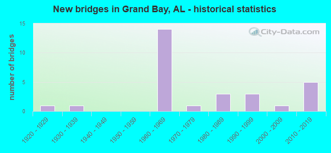
- New bridges - historical statistics
- 11920-1929
- 11930-1939
- 141960-1969
- 11970-1979
- 31980-1989
- 31990-1999
- 12000-2009
- 52010-2019
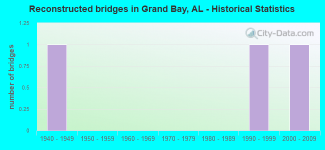
- Reconstructed bridges - Historical Statistics
- 11940-1949
- 01950-1959
- 01960-1969
- 01970-1979
- 01980-1989
- 11990-1999
- 12000-2009
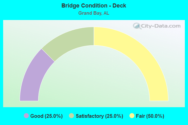
- Bridge Condition - Deck
- 25.0%Good
- 25.0%Satisfactory
- 50.0%Fair
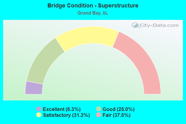
- Bridge Condition - Superstructure
- 6.3%Excellent
- 25.0%Good
- 31.3%Satisfactory
- 37.5%Fair
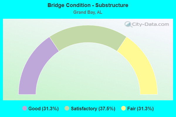
- Bridge Condition - Substructure
- 31.3%Good
- 37.5%Satisfactory
- 31.3%Fair
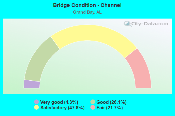
- Bridge Condition - Channel
- 4.3%Very good
- 26.1%Good
- 47.8%Satisfactory
- 21.7%Fair
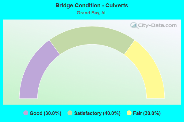
- Bridge Condition - Culverts
- 30.0%Good
- 40.0%Satisfactory
- 30.0%Fair
Find on map >> Show street view
Structure Number: 184, Location: 3 . 3 MI N JCT US 278 (Lat: 34.095000, Lng: -86.186667), Route carried "on" structure: State highway 179, Year Built: 1938, Status: Temporarily open, Structure Length: 1.98m (6.50ft), Average Daily Traffic: 1,861 (year 2018), Truck Traffic: 5%, Average Future Daily Traffic: 2,605 (year 2038), Design Load: H 10, Features Intersected: BRANCH
Minimum Vertical Clearance: 30+ m (98+ ft), Kilometerpoint: 5.377, Lanes on structure: 2, Owner: State Highway Agency, Approaching Roadway Width: 7.3m (24.0ft), Material/Design: Concrete, Design/Construction: Slab, Number Of Spans In Main Unit: 6, Length of Maximum Span: 3.0m (9.8ft), Curb-To-Curb Width: 9.1m (29.9ft), Out-to-Out Width: 9.9m (32.5ft)
Condition: Deck: Fair, Superstructure: Fair, Substructure: Fair, Channel: Fair, Operating Rating: 43.5 metric tons, Method Used To Determine Operating Rating: Field evaluation and documented engineering judgment, Inventory Rating: 32.7 metric tons, Method Used To Determine Inventory Rating: Field evaluation and documented engineering judgment, Structural Evaluation: Somewhat better than minimum adequacy, Deck Geometry: Somewhat better than minimum adequacy, Waterway Adequacy: Equal to present minimum criteria, Approach Roadway Alignment: Better than present minimum criteria, Length Of Structure Improvement: 2.73m (8.96ft), Designated Inspection Frequency: Every 24 months, Inspection Date: April 2020, Bridge Improvement Cost: $598,000, Roadway Improvement Cost: $60,000, Total Project Cost: $658,000 ( Estimate for 2022), Deck Structure Type: Concrete Cast-file-Place, Wearing Surface/Protective System: Wearing Surface: Bituminous
Find on map >> Show street view
Structure Number: 395, Location: 0.4 MI E ALA-MISS LINE (Lat: 30.457747, Lng: -88.394828), Route carried "on" structure: US 90, Year Built: 1925, Year Reconstructed: 1951, Status: Open, Structure Length: 4.45m (14.60ft), Average Daily Traffic: 5,607 (year 2018), Truck Traffic: 12%, Average Future Daily Traffic: 8,411 (year 2038), Design Load: H 15, Features Intersected: FRANKLIN CREEK
Minimum Vertical Clearance: 30+ m (98+ ft), Kilometerpoint: 0.700, Lanes on structure: 2, Owner: State Highway Agency, Approaching Roadway Width: 9.1m (29.9ft), Material/Design: Concrete, Design/Construction: Tee Beam, Number Of Spans In Main Unit: 4, Length of Maximum Span: 11.3m (37.1ft), Curb-To-Curb Width: 9.1m (29.9ft), Out-to-Out Width: 10.8m (35.4ft)
Condition: Deck: Fair, Superstructure: Fair, Substructure: Fair, Channel: Satisfactory, Operating Rating: 46.4 metric tons, Method Used To Determine Operating Rating: Load Factor (LF), Inventory Rating: 27.9 metric tons, Method Used To Determine Inventory Rating: Load Factor (LF), Structural Evaluation: Somewhat better than minimum adequacy, Deck Geometry: High priority of corrective action, Waterway Adequacy: Somewhat better than minimum adequacy, Approach Roadway Alignment: Better than present minimum criteria, Length Of Structure Improvement: 5.44m (17.85ft), Designated Inspection Frequency: Every 24 months, Underwater Inspection Frequency: Every 24 months, Inspection Date: July 2020, Underwater Inspection Date: August 2020, Bridge Improvement Cost: $1,305,000, Roadway Improvement Cost: $131,000, Total Project Cost: $1,436,000 ( Estimate for 2022), Deck Structure Type: Concrete Cast-file-Place
Find on map >> Show street view
Structure Number: 7587, Location: 0.3 MI N US 90 (Lat: 30.490308, Lng: -88.310228), Route carried "on" structure: County highway , Year Built: 1962, Status: Posted for load, Structure Length: 2.07m (6.79ft), Average Daily Traffic: 2,809 (year 2021), Truck Traffic: 4%, Average Future Daily Traffic: 4,174 (year 2041), Design Load: H 15, Features Intersected: FRANKLIN CREEK, Facility Carried by Structure: RAMSEY RD
Minimum Vertical Clearance: 30+ m (98+ ft), Kilometerpoint: 0.299, Lanes on structure: 2, Owner: County Highway Agency, Approaching Roadway Width: 7.3m (24.0ft), Material/Design: Concrete, Design/Construction: Tee Beam, Number Of Spans In Main Unit: 2, Length of Maximum Span: 10.4m (34.1ft), Curb or Sidewalk Widths: Left: 0.2m (0.7ft), Right: 0.2m (0.7ft), Curb-To-Curb Width: 6.6m (21.7ft), Out-to-Out Width: 7.1m (23.3ft)
Condition: Deck: Satisfactory, Superstructure: Satisfactory, Substructure: Satisfactory, Channel: Satisfactory, Operating Rating: 34.3 metric tons, Method Used To Determine Operating Rating: Load Factor (LF), Inventory Rating: 20.6 metric tons, Method Used To Determine Inventory Rating: Load Factor (LF), Structural Evaluation: Somewhat better than minimum adequacy, Deck Geometry: High priority of replacement, Waterway Adequacy: Equal to present desirable criteria, Approach Roadway Alignment: Equal to present desirable criteria, Bridge Posting: Required (Relationship of Operating Rating to Maximum Legal Load: 0.1 - 9.9% below), Length Of Structure Improvement: 2.84m (9.32ft), Designated Inspection Frequency: Every 24 months, Underwater Inspection Frequency: Every 24 months, Other Special Inspection Frequency: Every 12 months, Inspection Date: September 2020, Underwater Inspection Date: September 2020, Other Special Inspection Date: September 2021, Bridge Improvement Cost: $448,000, Roadway Improvement Cost: $45,000, Total Project Cost: $493,000 ( Estimate for 2022), Deck Structure Type: Concrete Cast-file-Place
Find on map >> Show street view
Structure Number: 8116, Location: 0.2 MI E MISS ST LINE (Lat: 30.474925, Lng: -88.399333), Route carried "on" structure: Interstate 10, Year Built: 1964, Status: Open, Structure Length: 10.36m (33.99ft), Average Daily Traffic: 21,001 (year 2020), Truck Traffic: 24%, Average Future Daily Traffic: 31,502 (year 2040), Design Load: HS 20, Features Intersected: FRANKLIN CREEK
Minimum Vertical Clearance: 30+ m (98+ ft), Kilometerpoint: 0.121, Lanes on structure: 2, Base Highway Network: Yes, Owner: State Highway Agency, Approaching Roadway Width: 11.3m (37.1ft), Skew: 14 degrees, Material/Design: Concrete, Design/Construction: Tee Beam, Number Of Spans In Main Unit: 10, Length of Maximum Span: 10.4m (34.1ft), Curb-To-Curb Width: 8.5m (27.9ft), Out-to-Out Width: 9.4m (30.8ft)
Condition: Deck: Fair, Superstructure: Fair, Substructure: Fair, Channel: Satisfactory, Operating Rating: 48.3 metric tons, Method Used To Determine Operating Rating: Load Factor (LF), Inventory Rating: 28.9 metric tons, Method Used To Determine Inventory Rating: Load Factor (LF), Structural Evaluation: Somewhat better than minimum adequacy, Deck Geometry: High priority of corrective action, Waterway Adequacy: Equal to present desirable criteria, Approach Roadway Alignment: Better than present minimum criteria, Length Of Structure Improvement: 11.28m (37.01ft), Designated Inspection Frequency: Every 24 months, Underwater Inspection Frequency: Every 24 months, Inspection Date: January 2022, Underwater Inspection Date: January 2022, Bridge Improvement Cost: $2,320,000, Roadway Improvement Cost: $232,000, Total Project Cost: $2,552,000 ( Estimate for 2022), Deck Structure Type: Concrete Cast-file-Place
Find on map >> Show street view
Structure Number: 8117, Location: 0.2 MI E MISS ST LINE (Lat: 30.474786, Lng: -88.398994), Route carried "on" structure: Interstate 10, Year Built: 1964, Status: Open, Structure Length: 10.36m (33.99ft), Average Daily Traffic: 21,001 (year 2020), Truck Traffic: 24%, Average Future Daily Traffic: 31,502 (year 2040), Design Load: HS 20, Features Intersected: FRANKLIN CREEK
Minimum Vertical Clearance: 30+ m (98+ ft), Kilometerpoint: 0.121, Lanes on structure: 2, Base Highway Network: Yes, Owner: State Highway Agency, Approaching Roadway Width: 11.3m (37.1ft), Skew: 14 degrees, Material/Design: Concrete, Design/Construction: Tee Beam, Number Of Spans In Main Unit: 10, Length of Maximum Span: 10.4m (34.1ft), Curb-To-Curb Width: 8.5m (27.9ft), Out-to-Out Width: 9.4m (30.8ft)
Condition: Deck: Fair, Superstructure: Fair, Substructure: Fair, Channel: Satisfactory, Operating Rating: 48.3 metric tons, Method Used To Determine Operating Rating: Load Factor (LF), Inventory Rating: 28.9 metric tons, Method Used To Determine Inventory Rating: Load Factor (LF), Structural Evaluation: Somewhat better than minimum adequacy, Deck Geometry: High priority of corrective action, Waterway Adequacy: Somewhat better than minimum adequacy, Approach Roadway Alignment: Equal to present desirable criteria, Length Of Structure Improvement: 11.28m (37.01ft), Designated Inspection Frequency: Every 24 months, Underwater Inspection Frequency: Every 24 months, Inspection Date: January 2022, Underwater Inspection Date: January 2022, Bridge Improvement Cost: $2,320,000, Roadway Improvement Cost: $232,000, Total Project Cost: $2,552,000 ( Estimate for 2022), Deck Structure Type: Concrete Cast-file-Place
Find on map >> Show street view
Structure Number: 8118, Location: 0.9 MI E MISS STATE LINE (Lat: 30.480878, Lng: -88.385683), Route carried "on" structure: County highway , Year Built: 1964, Status: Open, Structure Length: 8.63m (28.31ft), Average Daily Traffic: 1,800 (year 2020), Truck Traffic: 1%, Average Future Daily Traffic: 2,700 (year 2040), Design Load: H 20, Features Intersected: I-10, Facility Carried by Structure: HALL RD
Minimum Vertical Clearance: 30+ m (98+ ft), Kilometerpoint: 0.000, Lanes on structure: 2, Lanes under structure: 5, Owner: State Highway Agency, Approaching Roadway Width: 7.3m (24.0ft), Skew: 2 degrees, Material/Design: Concrete continuous, Design/Construction: Tee Beam, Number Of Spans In Main Unit: 4, Length of Maximum Span: 23.8m (78.1ft), Curb-To-Curb Width: 7.3m (24.0ft), Out-to-Out Width: 8.8m (28.9ft)
Condition: Deck: Fair, Superstructure: Fair, Substructure: Satisfactory, Operating Rating: 47.2 metric tons, Method Used To Determine Operating Rating: Load Factor (LF), Inventory Rating: 28.3 metric tons, Method Used To Determine Inventory Rating: Load Factor (LF), Structural Evaluation: Somewhat better than minimum adequacy, Deck Geometry: Meets minimum limits, Underclear: High priority of corrective action, Approach Roadway Alignment: Equal to present minimum criteria, Length Of Structure Improvement: 9.61m (31.53ft), Designated Inspection Frequency: Every 24 months, Inspection Date: December 2021, Bridge Improvement Cost: $1,846,000, Roadway Improvement Cost: $185,000, Total Project Cost: $2,031,000 ( Estimate for 2022), Deck Structure Type: Concrete Cast-file-Place
Find on map >> Show street view
Structure Number: 8119, Location: 1.6 MI E MISS ST LINE (Lat: 30.484808, Lng: -88.375308), Route carried "on" structure: Interstate 10, Year Built: 1964, Status: Open, Structure Length: 1.89m (6.20ft), Average Daily Traffic: 42,002 (year 2020), Truck Traffic: 24%, Average Future Daily Traffic: 63,003 (year 2040), Design Load: HS 20, Features Intersected: REEDY BRANCH
Minimum Vertical Clearance: 30+ m (98+ ft), Kilometerpoint: 2.651, Lanes on structure: 4, Base Highway Network: Yes, Owner: State Highway Agency, Approaching Roadway Width: 23.8m (78.1ft), Skew: 10 degrees, Material/Design: Concrete, Design/Construction: Culvert, Number Of Spans In Main Unit: 5, Length of Maximum Span: 3.7m (12.1ft)
Condition: Channel: Fair, Culverts: Satisfactory, Operating Rating: 74.2 metric tons, Method Used To Determine Operating Rating: Load Factor (LF), Inventory Rating: 44.5 metric tons, Method Used To Determine Inventory Rating: Load Factor (LF), Structural Evaluation: Equal to present minimum criteria, Waterway Adequacy: Better than present minimum criteria, Approach Roadway Alignment: Equal to present desirable criteria, Length Of Structure Improvement: 2.62m (8.60ft), Designated Inspection Frequency: Every 24 months, Inspection Date: December 2021, Bridge Improvement Cost: $2,341,000, Roadway Improvement Cost: $234,000, Total Project Cost: $2,575,000 ( Estimate for 2022)
Find on map >> Show street view
Structure Number: 812, Location: 3.2 MI E MISS ST LINE (Lat: 30.493378, Lng: -88.350444), Route carried "on" structure: Interstate 10, Year Built: 1964, Status: Open, Structure Length: 0.64m (2.10ft), Average Daily Traffic: 42,002 (year 2020), Truck Traffic: 24%, Average Future Daily Traffic: 63,003 (year 2040), Design Load: HS 20, Features Intersected: WARREN CREEK
Minimum Vertical Clearance: 30+ m (98+ ft), Kilometerpoint: 5.224, Lanes on structure: 4, Base Highway Network: Yes, Owner: State Highway Agency, Approaching Roadway Width: 23.5m (77.1ft), Skew: 10 degrees, Material/Design: Concrete, Design/Construction: Culvert, Number Of Spans In Main Unit: 2, Length of Maximum Span: 3.0m (9.8ft)
Condition: Channel: Fair, Culverts: Fair, Operating Rating: 88.9 metric tons, Method Used To Determine Operating Rating: Load Factor (LF), Inventory Rating: 88.9 metric tons, Method Used To Determine Inventory Rating: Load Factor (LF), Structural Evaluation: Somewhat better than minimum adequacy, Waterway Adequacy: Equal to present desirable criteria, Approach Roadway Alignment: Equal to present desirable criteria, Length Of Structure Improvement: 1.26m (4.13ft), Designated Inspection Frequency: Every 24 months, Inspection Date: December 2021, Bridge Improvement Cost: $1,310,000, Roadway Improvement Cost: $131,000, Total Project Cost: $1,441,000 ( Estimate for 2022)
Find on map >> Show street view
Structure Number: 8121, Location: 5.6 MI E MISS ST LINE (Lat: 30.501731, Lng: -88.310819), Route carried "on" structure: Interstate 10, Year Built: 1964, Status: Open, Structure Length: 0.64m (2.10ft), Average Daily Traffic: 45,043 (year 2020), Truck Traffic: 28%, Average Future Daily Traffic: 67,565 (year 2040), Design Load: HS 20, Features Intersected: FARMER BRANCH
Minimum Vertical Clearance: 30+ m (98+ ft), Kilometerpoint: 9.094, Lanes on structure: 4, Base Highway Network: Yes, Owner: State Highway Agency, Approaching Roadway Width: 23.5m (77.1ft), Skew: 14 degrees, Material/Design: Concrete, Design/Construction: Culvert, Number Of Spans In Main Unit: 2, Length of Maximum Span: 3.0m (9.8ft)
Condition: Channel: Fair, Culverts: Fair, Operating Rating: 53.3 metric tons, Method Used To Determine Operating Rating: Load Factor (LF), Inventory Rating: 31.8 metric tons, Method Used To Determine Inventory Rating: Load Factor (LF), Structural Evaluation: Somewhat better than minimum adequacy, Waterway Adequacy: Equal to present minimum criteria, Approach Roadway Alignment: Equal to present desirable criteria, Length Of Structure Improvement: 1.26m (4.13ft), Designated Inspection Frequency: Every 24 months, Inspection Date: December 2021, Bridge Improvement Cost: $1,565,000, Roadway Improvement Cost: $157,000, Total Project Cost: $1,722,000 ( Estimate for 2022)
Find on map >> Show street view
Structure Number: 8122, Location: 5.7 MI E MISS STATE LINE (Lat: 30.502333, Lng: -88.310172), Route carried "on" structure: County highway , Year Built: 1964, Status: Open, Structure Length: 8.63m (28.31ft), Average Daily Traffic: 2,092 (year 2020), Truck Traffic: 1%, Average Future Daily Traffic: 3,138 (year 2040), Design Load: H 20, Features Intersected: I-10, Facility Carried by Structure: RAMSEY RD
Minimum Vertical Clearance: 30+ m (98+ ft), Kilometerpoint: 0.000, Lanes on structure: 2, Lanes under structure: 4, Owner: State Highway Agency, Approaching Roadway Width: 7.3m (24.0ft), Skew: 2 degrees, Material/Design: Concrete continuous, Design/Construction: Tee Beam, Number Of Spans In Main Unit: 4, Length of Maximum Span: 23.8m (78.1ft), Curb-To-Curb Width: 7.3m (24.0ft), Out-to-Out Width: 8.8m (28.9ft)
Condition: Deck: Fair, Superstructure: Satisfactory, Substructure: Good, Operating Rating: 53.4 metric tons, Method Used To Determine Operating Rating: Allowable Stress (AS), Inventory Rating: 26.2 metric tons, Method Used To Determine Inventory Rating: Allowable Stress (AS), Structural Evaluation: Equal to present minimum criteria, Deck Geometry: High priority of replacement, Underclear: Meets minimum limits, Approach Roadway Alignment: Equal to present minimum criteria, Length Of Structure Improvement: 9.61m (31.53ft), Designated Inspection Frequency: Every 24 months, Inspection Date: December 2021, Bridge Improvement Cost: $1,845,000, Roadway Improvement Cost: $185,000, Total Project Cost: $2,030,000 ( Estimate for 2022), Deck Structure Type: Concrete Cast-file-Place
Find on map >> Show street view
Structure Number: 8123, Location: 7.8 MI E MISS ST LINE (Lat: 30.515525, Lng: -88.279347), Route carried "on" structure: Interstate 10, Year Built: 1964, Status: Open, Structure Length: 0.76m (2.49ft), Average Daily Traffic: 51,136 (year 2018), Truck Traffic: 24%, Average Future Daily Traffic: 76,704 (year 2038), Design Load: HS 20, Features Intersected: JACKSON CREEK
Minimum Vertical Clearance: 30+ m (98+ ft), Kilometerpoint: 12.521, Lanes on structure: 4, Base Highway Network: Yes, Owner: State Highway Agency, Approaching Roadway Width: 26.3m (86.3ft), Skew: 10 degrees, Material/Design: Concrete, Design/Construction: Culvert, Number Of Spans In Main Unit: 2, Length of Maximum Span: 3.7m (12.1ft)
Condition: Channel: Satisfactory, Culverts: Fair, Operating Rating: 88.9 metric tons, Method Used To Determine Operating Rating: Load Factor (LF), Inventory Rating: 88.9 metric tons, Method Used To Determine Inventory Rating: Load Factor (LF), Structural Evaluation: Somewhat better than minimum adequacy, Waterway Adequacy: Equal to present minimum criteria, Approach Roadway Alignment: Equal to present desirable criteria, Length Of Structure Improvement: 1.41m (4.63ft), Designated Inspection Frequency: Every 24 months, Inspection Date: June 2020, Bridge Improvement Cost: $1,551,000, Roadway Improvement Cost: $155,000, Total Project Cost: $1,706,000 ( Estimate for 2022)
Find on map >> Show street view
Structure Number: 8448, Location: 4.1 MI E MISS STATE LINE (Lat: 30.496703, Lng: -88.335428), Route carried "on" structure: State highway 188, Year Built: 1964, Status: Open, Structure Length: 8.63m (28.31ft), Average Daily Traffic: 8,874 (year 2019), Truck Traffic: 3%, Average Future Daily Traffic: 13,311 (year 2039), Design Load: H 20, Features Intersected: I-10
Minimum Vertical Clearance: 30+ m (98+ ft), Kilometerpoint: 0.153, Lanes on structure: 2, Lanes under structure: 4, Owner: State Highway Agency, Approaching Roadway Width: 7.6m (24.9ft), Skew: 3 degrees, Material/Design: Concrete continuous, Design/Construction: Tee Beam, Number Of Spans In Main Unit: 4, Length of Maximum Span: 23.8m (78.1ft), Curb-To-Curb Width: 7.3m (24.0ft), Out-to-Out Width: 8.8m (28.9ft)
Condition: Deck: Fair, Superstructure: Satisfactory, Substructure: Satisfactory, Operating Rating: 42.3 metric tons, Method Used To Determine Operating Rating: Load Factor (LF), Inventory Rating: 25.3 metric tons, Method Used To Determine Inventory Rating: Load Factor (LF), Structural Evaluation: Equal to present minimum criteria, Deck Geometry: High priority of replacement, Underclear: Somewhat better than minimum adequacy, Approach Roadway Alignment: Better than present minimum criteria, Length Of Structure Improvement: 9.61m (31.53ft), Designated Inspection Frequency: Every 24 months, Inspection Date: October 2020, Bridge Improvement Cost: $1,845,000, Roadway Improvement Cost: $185,000, Total Project Cost: $2,030,000 ( Estimate for 2022), Deck Structure Type: Concrete Cast-file-Place
Find on map >> Show street view
Structure Number: 8699, Location: 1.5 MI S AL 188 (Lat: 30.450836, Lng: -88.343392), Route carried "on" structure: County highway 11, Year Built: 1965, Status: Posted for load, Structure Length: 2.74m (8.99ft), Average Daily Traffic: 1,740 (year 2021), Truck Traffic: 2%, Average Future Daily Traffic: 2,586 (year 2041), Design Load: H 15, Features Intersected: S FORK FRANKLIN CREEK, Facility Carried by Structure: POTTER TRACT ROAD
Minimum Vertical Clearance: 30+ m (98+ ft), Kilometerpoint: 0.010, Lanes on structure: 2, Owner: County Highway Agency, Approaching Roadway Width: 7.6m (24.9ft), Material/Design: Concrete, Design/Construction: Tee Beam, Number Of Spans In Main Unit: 3, Length of Maximum Span: 9.1m (29.9ft), Curb or Sidewalk Widths: Left: 0.6m (2.0ft), Right: 0.6m (2.0ft), Curb-To-Curb Width: 7.2m (23.6ft), Out-to-Out Width: 8.3m (27.2ft)
Condition: Deck: Satisfactory, Superstructure: Satisfactory, Substructure: Good, Channel: Fair, Operating Rating: 37.1 metric tons, Method Used To Determine Operating Rating: Load Factor (LF), Inventory Rating: 22.3 metric tons, Method Used To Determine Inventory Rating: Load Factor (LF), Structural Evaluation: Somewhat better than minimum adequacy, Deck Geometry: High priority of corrective action, Waterway Adequacy: Better than present minimum criteria, Approach Roadway Alignment: Equal to present desirable criteria, Bridge Posting: Required (Relationship of Operating Rating to Maximum Legal Load: 0.1 - 9.9% below), Length Of Structure Improvement: 3.66m (12.01ft), Designated Inspection Frequency: Every 24 months, Underwater Inspection Frequency: Every 24 months, Other Special Inspection Frequency: Every 12 months, Inspection Date: April 2020, Underwater Inspection Date: April 2020, Other Special Inspection Date: April 2021, Bridge Improvement Cost: $678,000, Roadway Improvement Cost: $68,000, Total Project Cost: $746,000 ( Estimate for 2022), Deck Structure Type: Concrete Precast Panels
Find on map >> Show street view
Structure Number: 12227, Location: 0.3 MI S W I-10 (Lat: 30.492872, Lng: -88.337483), Route carried "on" structure: State highway 188, Year Built: 1979, Status: Open, Structure Length: 5.12m (16.80ft), Average Daily Traffic: 8,785 (year 2018), Truck Traffic: 3%, Average Future Daily Traffic: 13,178 (year 2038), Design Load: H 20, Features Intersected: FRANKLIN CREEK
Minimum Vertical Clearance: 30+ m (98+ ft), Kilometerpoint: 0.624, Lanes on structure: 2, Owner: State Highway Agency, Approaching Roadway Width: 9.1m (29.9ft), Material/Design: Concrete, Design/Construction: Channel Beam, Number Of Spans In Main Unit: 7, Length of Maximum Span: 7.3m (24.0ft), Curb-To-Curb Width: 10.8m (35.4ft), Out-to-Out Width: 11.6m (38.1ft)
Condition: Deck: Fair, Superstructure: Fair, Substructure: Fair, Channel: Satisfactory, Operating Rating: 49.7 metric tons, Method Used To Determine Operating Rating: Load Factor (LF), Inventory Rating: 29.8 metric tons, Method Used To Determine Inventory Rating: Load Factor (LF), Structural Evaluation: Somewhat better than minimum adequacy, Deck Geometry: Meets minimum limits, Waterway Adequacy: Meets minimum limits, Approach Roadway Alignment: Better than present minimum criteria, Length Of Structure Improvement: 6.14m (20.14ft), Designated Inspection Frequency: Every 24 months, Underwater Inspection Frequency: Every 24 months, Inspection Date: August 2020, Underwater Inspection Date: October 2020, Bridge Improvement Cost: $1,600,000, Roadway Improvement Cost: $160,000, Total Project Cost: $1,760,000 ( Estimate for 2022), Deck Structure Type: Concrete Precast Panels
Find on map >> Show street view
Structure Number: 13109, Location: 2.0 MI N CO 28 (Lat: 30.535967, Lng: -88.342203), Route carried "on" structure: County highway , Year Built: 1984, Year Reconstructed: 2014, Status: Open, Structure Length: 4.39m (14.40ft), Average Daily Traffic: 9,342 (year 2020), Truck Traffic: 4%, Average Future Daily Traffic: 9,424 (year 2024), Design Load: HS 20, Features Intersected: JACKSON CREEK, Facility Carried by Structure: GRANDBAY WILMER S
Minimum Vertical Clearance: 30+ m (98+ ft), Kilometerpoint: 1.999, Lanes on structure: 2, Owner: County Highway Agency, Approaching Roadway Width: 10.4m (34.1ft), Material/Design: Concrete, Design/Construction: Channel Beam, Number Of Spans In Main Unit: 6, Length of Maximum Span: 7.3m (24.0ft), Curb-To-Curb Width: 9.6m (31.5ft), Out-to-Out Width: 9.6m (31.5ft)
Condition: Deck: Satisfactory, Superstructure: Satisfactory, Substructure: Satisfactory, Channel: Satisfactory, Operating Rating: 53.5 metric tons, Method Used To Determine Operating Rating: Load Factor (LF), Inventory Rating: 31.8 metric tons, Method Used To Determine Inventory Rating: Load Factor (LF), Structural Evaluation: Equal to present minimum criteria, Deck Geometry: High priority of corrective action, Waterway Adequacy: Better than present minimum criteria, Approach Roadway Alignment: Better than present minimum criteria, Length Of Structure Improvement: 5.37m (17.62ft), Designated Inspection Frequency: Every 24 months, Underwater Inspection Frequency: Every 24 months, Inspection Date: July 2020, Underwater Inspection Date: July 2020, Bridge Improvement Cost: $1,142,000, Roadway Improvement Cost: $114,000, Total Project Cost: $1,256,000 ( Estimate for 2022), Deck Structure Type: Concrete Precast Panels, Wearing Surface/Protective System: Wearing Surface: Bituminous, Membrane: Built-up
Find on map >> Show street view
Structure Number: 13393, Location: MID-TOWN B.L.B. (Lat: 30.406419, Lng: -88.248028), Route carried "on" structure: State highway 188, Year Built: 1984, Status: Open, Structure Length: 7.50m (24.61ft), Average Daily Traffic: 12,655 (year 2018), Truck Traffic: 2%, Average Future Daily Traffic: 18,983 (year 2038), Design Load: HS 20, Features Intersected: BAYOU LA BATRE
Minimum Vertical Clearance: 22.86m (75.00ft), Kilometerpoint: 16.163, Lanes on structure: 3, Owner: State Highway Agency, Approaching Roadway Width: 14.9m (48.9ft), Navigation Control: Yes ( Vertical Clearance: 22.3m (73.2ft), Horizontal Clearance: 24.4m (80.1ft)), Material/Design: Steel, Design/Construction: Movable - Lift, Number Of Spans In Main Unit: 1, Number Of Approach Spans: 2, Length of Maximum Span: 31.7m (104.0ft), Curb or Sidewalk Widths: Left: 1.5m (4.9ft), Right: 0.0m, Curb-To-Curb Width: 15.8m (51.8ft), Out-to-Out Width: 18.4m (60.4ft)
Condition: Deck: Satisfactory, Superstructure: Good, Substructure: Satisfactory, Channel: Good, Operating Rating: 49.8 metric tons, Method Used To Determine Operating Rating: Load Factor (LF), Inventory Rating: 27.2 metric tons, Method Used To Determine Inventory Rating: Load Factor (LF), Structural Evaluation: Equal to present minimum criteria, Deck Geometry: Better than present minimum criteria, Waterway Adequacy: Equal to present minimum criteria, Approach Roadway Alignment: Better than present minimum criteria, Length Of Structure Improvement: 8.52m (27.95ft), Designated Inspection Frequency: Every 24 months, Critical Feature Inspection Frequency: Every 12 months, Underwater Inspection Frequency: Every 24 months, Inspection Date: August 2020, Critical Feature Inspection Date: August 2021, Underwater Inspection Date: March 2021, Bridge Improvement Cost: $3,505,000, Roadway Improvement Cost: $351,000, Total Project Cost: $3,856,000 ( Estimate for 2022), Deck Structure Type: Concrete Cast-file-Place
Find on map >> Show street view
Structure Number: 13517, Location: 0.5 MI S OF CO ROAD 28 (Lat: 30.521311, Lng: -88.293014), Route carried "on" structure: County highway , Year Built: 1985, Status: Open, Structure Length: 0.76m (2.49ft), Average Daily Traffic: 362 (year 2020), Truck Traffic: 4%, Average Future Daily Traffic: 538 (year 2040), Design Load: HS 20, Features Intersected: JACKSON CREEK, Facility Carried by Structure: LOCKWOOD DRIVE
Minimum Vertical Clearance: 30+ m (98+ ft), Kilometerpoint: 0.499, Lanes on structure: 2, Owner: County Highway Agency, Approaching Roadway Width: 6.4m (21.0ft), Material/Design: Concrete continuous, Design/Construction: Culvert, Number Of Spans In Main Unit: 2, Length of Maximum Span: 3.7m (12.1ft)
Condition: Channel: Satisfactory, Culverts: Good, Operating Rating: 88.9 metric tons, Method Used To Determine Operating Rating: Load Factor (LF), Inventory Rating: 65.8 metric tons, Method Used To Determine Inventory Rating: Load Factor (LF), Structural Evaluation: Better than present minimum criteria, Waterway Adequacy: Equal to present minimum criteria, Approach Roadway Alignment: Equal to present desirable criteria, Length Of Structure Improvement: 1.41m (4.63ft), Designated Inspection Frequency: Every 24 months, Inspection Date: September 2020, Bridge Improvement Cost: $406,000, Roadway Improvement Cost: $41,000, Total Project Cost: $447,000 ( Estimate for 2022)
Find on map >> Show street view
Structure Number: 15094, Location: 0.05 MI E JCT MCGREGOR RD (Lat: 30.487539, Lng: -88.352661), Route carried "on" structure: County highway , Year Built: 1990, Status: Open, Structure Length: 3.11m (10.20ft), Average Daily Traffic: 263 (year 2020), Truck Traffic: 4%, Average Future Daily Traffic: 391 (year 2040), Design Load: HS 20, Features Intersected: FRANKLIN CREEK, Facility Carried by Structure: WARREN CREEK ROAD
Minimum Vertical Clearance: 30+ m (98+ ft), Kilometerpoint: 0.010, Lanes on structure: 2, Owner: County Highway Agency, Approaching Roadway Width: 6.1m (20.0ft), Material/Design: Concrete, Design/Construction: Channel Beam, Number Of Spans In Main Unit: 3, Length of Maximum Span: 10.4m (34.1ft), Curb or Sidewalk Widths: Left: 0.3m (1.0ft), Right: 0.3m (1.0ft), Curb-To-Curb Width: 8.5m (27.9ft), Out-to-Out Width: 8.5m (27.9ft)
Condition: Deck: Good, Superstructure: Good, Substructure: Satisfactory, Channel: Satisfactory, Operating Rating: 71.7 metric tons, Method Used To Determine Operating Rating: Load Factor (LF), Inventory Rating: 43.0 metric tons, Method Used To Determine Inventory Rating: Load Factor (LF), Structural Evaluation: Equal to present minimum criteria, Deck Geometry: Equal to present minimum criteria, Waterway Adequacy: Better than present minimum criteria, Approach Roadway Alignment: Better than present minimum criteria, Length Of Structure Improvement: 3.96m (12.99ft), Designated Inspection Frequency: Every 24 months, Underwater Inspection Frequency: Every 24 months, Inspection Date: September 2020, Underwater Inspection Date: September 2020, Bridge Improvement Cost: $760,000, Roadway Improvement Cost: $76,000, Total Project Cost: $836,000 ( Estimate for 2022)
Find on map >> Show street view
Structure Number: 16112, Location: 0.7 MI. N. SR 188 (Lat: 30.482231, Lng: -88.309981), Route carried "on" structure: County highway , Year Built: 1994, Status: Open, Structure Length: 0.94m (3.08ft), Average Daily Traffic: 2,826 (year 2020), Truck Traffic: 3%, Average Future Daily Traffic: 4,199 (year 2040), Design Load: HS 20, Features Intersected: BRANCH OF FRANKLIN CREEK, Facility Carried by Structure: RAMSEY RD
Minimum Vertical Clearance: 30+ m (98+ ft), Kilometerpoint: 0.000, Lanes on structure: 2, Owner: County Highway Agency, Approaching Roadway Width: 8.7m (28.5ft), Skew: 1 degrees, Material/Design: Concrete continuous, Design/Construction: Culvert, Number Of Spans In Main Unit: 3, Length of Maximum Span: 3.0m (9.8ft)
Condition: Channel: Satisfactory, Culverts: Satisfactory, Operating Rating: 77.3 metric tons, Method Used To Determine Operating Rating: Load Factor (LF), Inventory Rating: 46.4 metric tons, Method Used To Determine Inventory Rating: Load Factor (LF), Structural Evaluation: Equal to present minimum criteria, Waterway Adequacy: Better than present minimum criteria, Approach Roadway Alignment: Equal to present desirable criteria, Length Of Structure Improvement: 1.62m (5.31ft), Designated Inspection Frequency: Every 24 months, Inspection Date: April 2020, Bridge Improvement Cost: $561,000, Roadway Improvement Cost: $56,000, Total Project Cost: $617,000 ( Estimate for 2022)
Find on map >> Show street view
Structure Number: 16533, Location: 0.5MI N MCCLINTON RD (Lat: 30.435867, Lng: -88.351731), Route carried "on" structure: County highway , Year Built: 1996, Year Reconstructed: 2004, Status: Open, Structure Length: 1.01m (3.31ft), Average Daily Traffic: 65 (year 2020), Average Future Daily Traffic: 97 (year 2040), Design Load: HS 20, Features Intersected: CREEK, Facility Carried by Structure: MILLER LN
Minimum Vertical Clearance: 30+ m (98+ ft), Kilometerpoint: 0.010, Lanes on structure: 2, Owner: County Highway Agency, Approaching Roadway Width: 5.5m (18.0ft), Material/Design: Concrete, Design/Construction: Culvert, Number Of Spans In Main Unit: 4, Length of Maximum Span: 2.8m (9.2ft)
Condition: Channel: Good, Culverts: Satisfactory, Operating Rating: 43.5 metric tons, Method Used To Determine Operating Rating: Field evaluation and documented engineering judgment, Inventory Rating: 32.7 metric tons, Method Used To Determine Inventory Rating: Field evaluation and documented engineering judgment, Structural Evaluation: Equal to present minimum criteria, Waterway Adequacy: Equal to present desirable criteria, Approach Roadway Alignment: Equal to present desirable criteria, Length Of Structure Improvement: 1.68m (5.51ft), Designated Inspection Frequency: Every 24 months, Inspection Date: April 2020, Bridge Improvement Cost: $377,000, Roadway Improvement Cost: $38,000, Total Project Cost: $415,000 ( Estimate for 2022)
Find on map >> Show street view
Structure Number: 18639, Location: 0.1 MI N US 90 (Lat: 30.470133, Lng: -88.385936), Route carried "on" structure: County highway , Year Built: 2004, Status: Open, Structure Length: 4.88m (16.01ft), Average Daily Traffic: 960 (year 2020), Truck Traffic: 4%, Average Future Daily Traffic: 1,427 (year 2040), Design Load: HS 20, Features Intersected: FRANKLIN CREEK, Facility Carried by Structure: HALL ROAD
Minimum Vertical Clearance: 30+ m (98+ ft), Kilometerpoint: 0.016, Lanes on structure: 2, Owner: County Highway Agency, Approaching Roadway Width: 6.6m (21.7ft), Material/Design: Concrete, Design/Construction: Channel Beam, Number Of Spans In Main Unit: 4, Length of Maximum Span: 12.2m (40.0ft), Curb-To-Curb Width: 8.6m (28.2ft), Out-to-Out Width: 8.8m (28.9ft)
Condition: Deck: Good, Superstructure: Good, Substructure: Good, Channel: Satisfactory, Operating Rating: 88.9 metric tons, Method Used To Determine Operating Rating: Load Factor (LF), Inventory Rating: 55.6 metric tons, Method Used To Determine Inventory Rating: Load Factor (LF), Structural Evaluation: Better than present minimum criteria, Deck Geometry: Somewhat better than minimum adequacy, Waterway Adequacy: Better than present minimum criteria, Approach Roadway Alignment: Equal to present desirable criteria, Length Of Structure Improvement: 5.89m (19.32ft), Designated Inspection Frequency: Every 24 months, Inspection Date: September 2020, Bridge Improvement Cost: $1,171,000, Roadway Improvement Cost: $117,000, Total Project Cost: $1,288,000 ( Estimate for 2022), Deck Structure Type: Concrete Precast Panels
Find on map >> Show street view
Structure Number: 18923, Location: 1.8 MI E SR 188 (Lat: 30.458000, Lng: -88.394700), Route carried "on" structure: US 90, Year Built: 2011, Status: Open, Structure Length: 1.14m (3.74ft), Average Daily Traffic: 5,357 (year 2019), Truck Traffic: 4%, Average Future Daily Traffic: 8,035 (year 2039), Design Load: HS 20, Features Intersected: FRANKLIN CREEK
Minimum Vertical Clearance: 30+ m (98+ ft), Kilometerpoint: 8.736, Lanes on structure: 2, Owner: State Highway Agency, Approaching Roadway Width: 9.8m (32.2ft), Material/Design: Concrete continuous, Design/Construction: Culvert, Number Of Spans In Main Unit: 3, Length of Maximum Span: 3.7m (12.1ft), Curb-To-Curb Width: 12.3m (40.4ft), Out-to-Out Width: 13.1m (43.0ft)
Condition: Channel: Very good, Culverts: Good, Operating Rating: 88.9 metric tons, Method Used To Determine Operating Rating: Load Factor (LF), Inventory Rating: 79.6 metric tons, Method Used To Determine Inventory Rating: Load Factor (LF), Structural Evaluation: Better than present minimum criteria, Deck Geometry: Somewhat better than minimum adequacy, Waterway Adequacy: Equal to present minimum criteria, Approach Roadway Alignment: Equal to present desirable criteria, Length Of Structure Improvement: 1.81m (5.94ft), Designated Inspection Frequency: Every 24 months, Inspection Date: July 2021, Bridge Improvement Cost: $450,000, Roadway Improvement Cost: $45,000, Total Project Cost: $495,000 ( Estimate for 2022)
Find on map >> Show street view
Structure Number: 20664, Location: 1,970' N OF TWO MILE ROAD (Lat: 30.478114, Lng: -88.292903), Route carried "on" structure: County highway 756, Year Built: 2012, Status: Open, Structure Length: 0.64m (2.10ft), Average Daily Traffic: 2,397 (year 2020), Truck Traffic: 3%, Average Future Daily Traffic: 3,562 (year 2040), Features Intersected: BRANCH OF FRANKLIN CREEK, Facility Carried by Structure: FERNLAND ROAD
Minimum Vertical Clearance: 30+ m (98+ ft), Kilometerpoint: 0.000, Lanes on structure: 2, Owner: County Highway Agency, Approaching Roadway Width: 6.7m (22.0ft), Material/Design: Concrete continuous, Design/Construction: Culvert, Number Of Spans In Main Unit: 2, Length of Maximum Span: 3.0m (9.8ft), Out-to-Out Width: 6.7m (22.0ft)
Condition: Channel: Good, Culverts: Good, Operating Rating: 70.7 metric tons, Method Used To Determine Operating Rating: Load Factor (LF), Inventory Rating: 42.4 metric tons, Method Used To Determine Inventory Rating: Load Factor (LF), Structural Evaluation: Better than present minimum criteria, Waterway Adequacy: Better than present minimum criteria, Approach Roadway Alignment: Equal to present minimum criteria, Length Of Structure Improvement: 1.26m (4.13ft), Designated Inspection Frequency: Every 24 months, Inspection Date: April 2020, Bridge Improvement Cost: $480,000, Roadway Improvement Cost: $48,000, Total Project Cost: $528,000 ( Estimate for 2022), Wearing Surface/Protective System: Wearing Surface: Bituminous
Find on map >> Show street view
Structure Number: 20753, Location: 1.0 MI W OF MARCH RD (Lat: 30.526833, Lng: -88.295444), Route carried "on" structure: County highway 28, Year Built: 2015, Status: Open, Structure Length: 6.40m (21.00ft), Average Daily Traffic: 4,588 (year 2020), Truck Traffic: 2%, Average Future Daily Traffic: 6,818 (year 2040), Design Load: HS 20, Features Intersected: JACKSON CREEK, Facility Carried by Structure: OLD PASCAGOULA RD
Minimum Vertical Clearance: 30+ m (98+ ft), Kilometerpoint: 0.000, Lanes on structure: 2, Owner: County Highway Agency, Approaching Roadway Width: 7.3m (24.0ft), Material/Design: Prestressed concrete, Design/Construction: Stringer/Multi-beam, Number Of Spans In Main Unit: 5, Length of Maximum Span: 12.8m (42.0ft), Curb-To-Curb Width: 12.2m (40.0ft), Out-to-Out Width: 13.0m (42.7ft)
Condition: Deck: Good, Superstructure: Excellent, Substructure: Good, Channel: Good, Operating Rating: 50.8 metric tons, Method Used To Determine Operating Rating: Load Factor (LF), Inventory Rating: 30.4 metric tons, Method Used To Determine Inventory Rating: Load Factor (LF), Structural Evaluation: Better than present minimum criteria, Deck Geometry: Equal to present minimum criteria, Waterway Adequacy: Better than present minimum criteria, Approach Roadway Alignment: Equal to present desirable criteria, Length Of Structure Improvement: 7.44m (24.41ft), Designated Inspection Frequency: Every 24 months, Inspection Date: September 2020, Bridge Improvement Cost: $2,143,000, Roadway Improvement Cost: $214,000, Total Project Cost: $2,357,000 ( Estimate for 2022), Deck Structure Type: Concrete Cast-file-Place
Find on map >> Show street view
Structure Number: 21203, Location: 0.7 ML N Hugh Fort Rd (Lat: 30.455608, Lng: -88.326569), Route carried "on" structure: County highway 960, Year Built: 2015, Status: Open, Structure Length: 3.11m (10.20ft), Average Daily Traffic: 1,164 (year 2020), Truck Traffic: 1%, Average Future Daily Traffic: 1,730 (year 2040), Design Load: HS 20, Features Intersected: S FORK FRANKLIN CREEK, Facility Carried by Structure: HENDERSON CAMP RD
Minimum Vertical Clearance: 30+ m (98+ ft), Kilometerpoint: 0.000, Lanes on structure: 2, Owner: County Highway Agency, Approaching Roadway Width: 7.0m (23.0ft), Material/Design: Concrete, Design/Construction: Channel Beam, Number Of Spans In Main Unit: 3, Length of Maximum Span: 10.4m (34.1ft), Curb-To-Curb Width: 8.6m (28.2ft), Out-to-Out Width: 8.6m (28.2ft)
Condition: Deck: Good, Superstructure: Good, Substructure: Good, Channel: Good, Operating Rating: 71.7 metric tons, Method Used To Determine Operating Rating: Load Factor (LF), Inventory Rating: 43.0 metric tons, Method Used To Determine Inventory Rating: Load Factor (LF), Structural Evaluation: Better than present minimum criteria, Deck Geometry: Somewhat better than minimum adequacy, Waterway Adequacy: Equal to present desirable criteria, Approach Roadway Alignment: Equal to present desirable criteria, Length Of Structure Improvement: 3.96m (12.99ft), Designated Inspection Frequency: Every 24 months, Inspection Date: April 2020, Bridge Improvement Cost: $760,000, Roadway Improvement Cost: $76,000, Total Project Cost: $836,000 ( Estimate for 2022)
Find on map >> Show street view
Structure Number: 21538, Location: 0.8 MI W OF CO RD 11 (Lat: 30.497603, Lng: -88.348519), Route carried "on" structure: County highway , Year Built: 2019, Status: Open, Structure Length: 0.64m (2.10ft), Average Daily Traffic: 405 (year 2020), Truck Traffic: 3%, Average Future Daily Traffic: 602 (year 2040), Design Load: HS 20, Features Intersected: UNNAMED CREEK, Facility Carried by Structure: CREEL ROAD
Minimum Vertical Clearance: 30+ m (98+ ft), Kilometerpoint: 0.000, Lanes on structure: 2, Owner: County Highway Agency, Approaching Roadway Width: 6.4m (21.0ft), Material/Design: Concrete, Design/Construction: Culvert, Number Of Spans In Main Unit: 3, Length of Maximum Span: 1.8m (5.9ft)
Condition: Channel: Good, Culverts: Satisfactory, Operating Rating: 43.5 metric tons, Method Used To Determine Operating Rating: Field evaluation and documented engineering judgment, Inventory Rating: 32.7 metric tons, Method Used To Determine Inventory Rating: Field evaluation and documented engineering judgment, Structural Evaluation: Equal to present minimum criteria, Waterway Adequacy: Better than present minimum criteria, Approach Roadway Alignment: Equal to present desirable criteria, Length Of Structure Improvement: 1.26m (4.13ft), Designated Inspection Frequency: Every 24 months, Inspection Date: September 2020, Bridge Improvement Cost: $348,000, Roadway Improvement Cost: $35,000, Total Project Cost: $383,000 ( Estimate for 2022)
Find on map >> Show street view
Structure Number: 8118, Location: 0.9 MI E MISS STATE LINE (Lat: 30.480878, Lng: -88.385683), Route carried "under" structure: Interstate 10, Year Built: 1964, Structure Length: 0. m, Average Daily Traffic: 42,002 (year 2020), Truck Traffic: 24%, Features Intersected: I-10, Facility Carried by Structure: HALL RD
Minimum Vertical Clearance: 4.86m (15.94ft), Kilometerpoint: 1.468, Lanes on structure: 2, Lanes under structure: 5, Material/Design: Concrete continuous, Design/Construction: Tee Beam, Length of Maximum Span: 23.8m (78.1ft)
Find on map >> Show street view
Structure Number: 8122, Location: 5.7 MI E MISS STATE LINE (Lat: 30.502333, Lng: -88.310172), Route carried "under" structure: Interstate 10, Year Built: 1964, Structure Length: 0. m, Average Daily Traffic: 45,043 (year 2020), Truck Traffic: 28%, Features Intersected: I-10, Facility Carried by Structure: RAMSEY RD
Minimum Vertical Clearance: 5.17m (16.96ft), Kilometerpoint: 9.193, Lanes on structure: 2, Lanes under structure: 4, Material/Design: Concrete continuous, Design/Construction: Tee Beam, Length of Maximum Span: 23.8m (78.1ft)
Find on map >> Show street view
Structure Number: 8448, Location: 4.1 MI E MISS STATE LINE (Lat: 30.496703, Lng: -88.335428), Route carried "under" structure: Interstate 10, Year Built: 1964, Structure Length: 0. m, Average Daily Traffic: 50,673 (year 2019), Truck Traffic: 24%, Features Intersected: I-10, Facility Carried by Structure: SR 188
Minimum Vertical Clearance: 5.07m (16.63ft), Kilometerpoint: 6.618, Lanes on structure: 2, Lanes under structure: 4, Material/Design: Concrete continuous, Design/Construction: Tee Beam, Length of Maximum Span: 23.8m (78.1ft)