Bridge Statistics for Grafton, West Virginia (WV)
Condition, Traffic, Stress, Structural Evaluation, Project Costs
- National Bridge Inventory (NBI) Statistics
- 36Number of bridges
- 456ft / 139mTotal length
- $2,390,000Total costs
- 64,990Total average daily traffic
- 4,608Total average daily truck traffic
- National Bridge Inventory (NBI) Registered Bridges for Grafton
- No street view available for this location
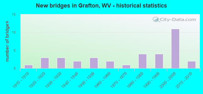
- New bridges - historical statistics
- 11910-1919
- 31920-1929
- 31930-1939
- 21940-1949
- 31950-1959
- 21960-1969
- 11970-1979
- 41980-1989
- 41990-1999
- 112000-2009
- 22010-2019


- Bridge Condition - Deck
- 57.9%Good
- 21.1%Satisfactory
- 21.1%Fair

- Bridge Condition - Superstructure
- 15.4%Very good
- 50.0%Good
- 15.4%Satisfactory
- 15.4%Fair
- 3.8%Poor

- Bridge Condition - Substructure
- 12.0%Very good
- 48.0%Good
- 20.0%Satisfactory
- 20.0%Fair

- Bridge Condition - Channel
- 7.1%Excellent
- 28.6%Very good
- 25.0%Good
- 21.4%Satisfactory
- 10.7%Fair
- 7.1%Poor

- Bridge Condition - Culverts
- 25.0%Good
- 75.0%Satisfactory
Find on map >> Show street view
Structure Number: 25A188, Location: 0.01 MI NORTH CO RT 31/14 (Lat: 39.398869, Lng: -80.047350), Route carried "on" structure: State highway 31000, Year Built: 1926, Status: Open, Structure Length: 0.91m (2.99ft), Average Daily Traffic: 1,200 (year 2018), Truck Traffic: 6%, Average Future Daily Traffic: 1,475 (year 2038), Features Intersected: GLADY CREEK, Facility Carried by Structure: WV ROUTE 310
Minimum Vertical Clearance: 30+ m (98+ ft), Kilometerpoint: 0.177, Lanes on structure: 2, Owner: State Highway Agency, Approaching Roadway Width: 6.7m (22.0ft), Skew: 1 degrees, Material/Design: Concrete, Design/Construction: Arch - Deck, Number Of Spans In Main Unit: 1, Length of Maximum Span: 9.1m (29.9ft), Curb-To-Curb Width: 7.8m (25.6ft), Out-to-Out Width: 8.3m (27.2ft)
Condition: Superstructure: Poor, Substructure: Fair, Channel: Fair, Operating Rating: 60.8 metric tons, Method Used To Determine Operating Rating: Field evaluation and documented engineering judgment, Inventory Rating: 28.1 metric tons, Method Used To Determine Inventory Rating: Field evaluation and documented engineering judgment, Structural Evaluation: Meets minimum limits, Deck Geometry: Meets minimum limits, Waterway Adequacy: Somewhat better than minimum adequacy, Approach Roadway Alignment: Equal to present desirable criteria, Designated Inspection Frequency: Every 24 months, Other Special Inspection Frequency: Every 12 months, Inspection Date: October 2020, Other Special Inspection Date: October 2021
Find on map >> Show street view
Structure Number: 46A011, Location: 0.17 MI SOUTH CO RT 24 (Lat: 39.398700, Lng: -80.024039), Route carried "on" structure: County highway 501, Year Built: 1917, Status: Open, Structure Length: 0.73m (2.40ft), Average Daily Traffic: 50 (year 2019), Average Future Daily Traffic: 60 (year 2041), Features Intersected: GLADY CREEK, Facility Carried by Structure: TAYLOR CO RT 5/1
Minimum Vertical Clearance: 30+ m (98+ ft), Kilometerpoint: 0.692, Lanes on structure: 1, Owner: State Highway Agency, Approaching Roadway Width: 5.5m (18.0ft), Material/Design: Concrete, Design/Construction: Arch - Deck, Number Of Spans In Main Unit: 1, Length of Maximum Span: 7.3m (24.0ft), Curb-To-Curb Width: 4.3m (14.1ft), Out-to-Out Width: 4.9m (16.1ft)
Condition: Superstructure: Fair, Channel: Poor, Operating Rating: 47.2 metric tons, Method Used To Determine Operating Rating: Field evaluation and documented engineering judgment, Inventory Rating: 21.8 metric tons, Method Used To Determine Inventory Rating: Field evaluation and documented engineering judgment, Structural Evaluation: Somewhat better than minimum adequacy, Deck Geometry: Equal to present minimum criteria, Waterway Adequacy: Meets minimum limits, Approach Roadway Alignment: Better than present minimum criteria, Length Of Structure Improvement: 1.37m (4.49ft), Designated Inspection Frequency: Every 24 months, Inspection Date: March 2021, Bridge Improvement Cost: $172,000, Roadway Improvement Cost: $131,000, Total Project Cost: $354,000 ( Estimate for 2021)
Find on map >> Show street view
Structure Number: 46A018, Location: 0.29 MI EAST TAY CR 12/1 (Lat: 39.354950, Lng: -80.096900), Route carried "on" structure: County highway 1200, Year Built: 1924, Status: Open, Structure Length: 0.99m (3.25ft), Average Daily Traffic: 150 (year 2019), Truck Traffic: 8%, Average Future Daily Traffic: 270 (year 2041), Features Intersected: LOST RUN, Facility Carried by Structure: TAYLOR CO RT 12
Minimum Vertical Clearance: 30+ m (98+ ft), Kilometerpoint: 2.060, Lanes on structure: 1, Owner: State Highway Agency, Approaching Roadway Width: 3.7m (12.1ft), Skew: 1 degrees, Material/Design: Concrete, Design/Construction: Arch - Deck, Number Of Spans In Main Unit: 1, Length of Maximum Span: 9.9m (32.5ft), Curb or Sidewalk Widths: Left: 0.1m (0.3ft), Right: 0.1m (0.3ft), Curb-To-Curb Width: 4.1m (13.5ft), Out-to-Out Width: 4.9m (16.1ft)
Condition: Superstructure: Satisfactory, Substructure: Satisfactory, Channel: Satisfactory, Operating Rating: 47.2 metric tons, Method Used To Determine Operating Rating: Field evaluation and documented engineering judgment, Inventory Rating: 21.8 metric tons, Method Used To Determine Inventory Rating: Field evaluation and documented engineering judgment, Structural Evaluation: Equal to present minimum criteria, Deck Geometry: High priority of replacement, Waterway Adequacy: Equal to present minimum criteria, Approach Roadway Alignment: Better than present minimum criteria, Length Of Structure Improvement: 2.19m (7.19ft), Designated Inspection Frequency: Every 24 months, Inspection Date: March 2021, Bridge Improvement Cost: $222,000, Roadway Improvement Cost: $183,000, Total Project Cost: $491,000 ( Estimate for 2021)
Find on map >> Show street view
Structure Number: 46A028, Location: 0.09 MI SOUTH CO RT 26 (Lat: 39.374000, Lng: -80.004689), Route carried "on" structure: County highway 2000, Year Built: 1985, Status: Open, Structure Length: 2.77m (9.09ft), Average Daily Traffic: 300 (year 2018), Truck Traffic: 6%, Average Future Daily Traffic: 350 (year 2038), Design Load: HS 20, Features Intersected: WICKWIRE RUN, Facility Carried by Structure: TAYLOR CO RT 20
Minimum Vertical Clearance: 30+ m (98+ ft), Kilometerpoint: 0.708, Lanes on structure: 2, Owner: State Highway Agency, Approaching Roadway Width: 6.7m (22.0ft), Skew: 3 degrees, Material/Design: Steel continuous, Design/Construction: Stringer/Multi-beam, Number Of Spans In Main Unit: 2, Length of Maximum Span: 12.8m (42.0ft), Curb-To-Curb Width: 6.7m (22.0ft), Out-to-Out Width: 7.8m (25.6ft)
Condition: Deck: Good, Superstructure: Good, Substructure: Good, Channel: Satisfactory, Operating Rating: 66.2 metric tons, Method Used To Determine Operating Rating: Load Factor (LF), Inventory Rating: 39.9 metric tons, Method Used To Determine Inventory Rating: Load Factor (LF), Structural Evaluation: Better than present minimum criteria, Deck Geometry: Meets minimum limits, Waterway Adequacy: Better than present minimum criteria, Approach Roadway Alignment: Better than present minimum criteria, Designated Inspection Frequency: Every 48 months, Inspection Date: June 2020, Deck Structure Type: Concrete Cast-file-Place, Wearing Surface/Protective System: Deck Protection: Epoxy Coated Reinforcing
Find on map >> Show street view
Structure Number: 46A029, Location: 0.06 MI SOUTH CO RT 26/3 (Lat: 39.380711, Lng: -79.975900), Route carried "on" structure: County highway 2600, Year Built: 1923, Status: Open, Structure Length: 0.88m (2.89ft), Average Daily Traffic: 250 (year 2019), Truck Traffic: 18%, Average Future Daily Traffic: 305 (year 2041), Features Intersected: WICKWIRE RUN, Facility Carried by Structure: TAYLOR CO RT 26
Minimum Vertical Clearance: 30+ m (98+ ft), Kilometerpoint: 2.655, Lanes on structure: 2, Owner: State Highway Agency, Approaching Roadway Width: 5.8m (19.0ft), Skew: 1 degrees, Material/Design: Concrete, Design/Construction: Arch - Deck, Number Of Spans In Main Unit: 1, Length of Maximum Span: 8.8m (28.9ft), Curb-To-Curb Width: 5.5m (18.0ft), Out-to-Out Width: 6.2m (20.3ft)
Condition: Superstructure: Fair, Substructure: Fair, Channel: Good, Operating Rating: 47.2 metric tons, Method Used To Determine Operating Rating: Field evaluation and documented engineering judgment, Inventory Rating: 21.8 metric tons, Method Used To Determine Inventory Rating: Field evaluation and documented engineering judgment, Structural Evaluation: Somewhat better than minimum adequacy, Deck Geometry: High priority of corrective action, Waterway Adequacy: Equal to present desirable criteria, Approach Roadway Alignment: Somewhat better than minimum adequacy, Length Of Structure Improvement: 1.71m (5.61ft), Designated Inspection Frequency: Every 24 months, Inspection Date: March 2021, Bridge Improvement Cost: $207,000, Roadway Improvement Cost: $156,000, Total Project Cost: $448,000 ( Estimate for 2021)
Find on map >> Show street view
Structure Number: 46A034, Location: 0.58 MI SOUTH CR 250/12 (Lat: 39.294231, Lng: -80.055489), Route carried "on" structure: County highway 3800, Year Built: 1987, Status: Open, Structure Length: 1.02m (3.35ft), Average Daily Traffic: 200 (year 2019), Truck Traffic: 8%, Average Future Daily Traffic: 350 (year 2041), Design Load: HS 20, Features Intersected: SHELBY RUN, Facility Carried by Structure: TAYLOR CO RT 38
Minimum Vertical Clearance: 30+ m (98+ ft), Kilometerpoint: 1.014, Lanes on structure: 1, Owner: State Highway Agency, Approaching Roadway Width: 5.2m (17.1ft), Skew: 2 degrees, Material/Design: Prestressed concrete, Design/Construction: Box Beam or Girders - Multiple, Number Of Spans In Main Unit: 1, Length of Maximum Span: 9.8m (32.2ft), Curb-To-Curb Width: 4.5m (14.8ft), Out-to-Out Width: 4.6m (15.1ft)
Condition: Deck: Satisfactory, Superstructure: Satisfactory, Substructure: Satisfactory, Channel: Poor, Operating Rating: 88.9 metric tons, Method Used To Determine Operating Rating: Load Factor (LF), Inventory Rating: 60.8 metric tons, Method Used To Determine Inventory Rating: Load Factor (LF), Structural Evaluation: Equal to present minimum criteria, Deck Geometry: High priority of replacement, Waterway Adequacy: Equal to present minimum criteria, Approach Roadway Alignment: Equal to present minimum criteria, Length Of Structure Improvement: 1.07m (3.51ft), Designated Inspection Frequency: Every 24 months, Inspection Date: May 2021, Bridge Improvement Cost: $164,000, Roadway Improvement Cost: $117,000, Total Project Cost: $311,000 ( Estimate for 2021), Deck Structure Type: Other, Wearing Surface/Protective System: Wearing Surface: Bituminous, Deck Protection: Epoxy Coated Reinforcing
Find on map >> Show street view
Structure Number: 46A035, Location: 0.17 MI SOUTH CO RT 38/2 (Lat: 39.306069, Lng: -80.071511), Route carried "on" structure: County highway 3800, Year Built: 1941, Status: Open, Structure Length: 0.73m (2.40ft), Average Daily Traffic: 200 (year 2019), Truck Traffic: 8%, Average Future Daily Traffic: 350 (year 2041), Features Intersected: SHELBY RUN, Facility Carried by Structure: TAYLOR CO RT 38
Minimum Vertical Clearance: 30+ m (98+ ft), Kilometerpoint: 3.476, Lanes on structure: 2, Owner: State Highway Agency, Approaching Roadway Width: 4.0m (13.1ft), Skew: 4 degrees, Material/Design: Concrete, Design/Construction: Slab, Number Of Spans In Main Unit: 1, Length of Maximum Span: 6.4m (21.0ft), Curb-To-Curb Width: 5.5m (18.0ft), Out-to-Out Width: 6.5m (21.3ft)
Condition: Deck: Fair, Superstructure: Fair, Substructure: Fair, Channel: Fair, Operating Rating: 47.2 metric tons, Method Used To Determine Operating Rating: Field evaluation and documented engineering judgment, Inventory Rating: 21.8 metric tons, Method Used To Determine Inventory Rating: Field evaluation and documented engineering judgment, Structural Evaluation: Somewhat better than minimum adequacy, Deck Geometry: High priority of corrective action, Waterway Adequacy: Somewhat better than minimum adequacy, Approach Roadway Alignment: Equal to present minimum criteria, Length Of Structure Improvement: 1.31m (4.30ft), Designated Inspection Frequency: Every 24 months, Inspection Date: May 2021, Bridge Improvement Cost: $193,000, Roadway Improvement Cost: $132,000, Total Project Cost: $374,000 ( Estimate for 2021), Deck Structure Type: Concrete Cast-file-Place, Wearing Surface/Protective System: Wearing Surface: Bituminous
Find on map >> Show street view
Structure Number: 46A037, Location: 0.32 MI EAST CO RT 50/4 (Lat: 39.344381, Lng: -80.058769), Route carried "on" structure: US 5000, Year Built: 1958, Status: Open, Structure Length: 0.73m (2.40ft), Average Daily Traffic: 8,200 (year 2019), Truck Traffic: 7%, Average Future Daily Traffic: 9,600 (year 2039), Features Intersected: OTTER CREEK, Facility Carried by Structure: US ROUTE 50
Minimum Vertical Clearance: 30+ m (98+ ft), Kilometerpoint: 14.935, Lanes on structure: 2, Owner: State Highway Agency, Approaching Roadway Width: 13.4m (44.0ft), Skew: 3 degrees, Material/Design: Concrete continuous, Design/Construction: Culvert, Number Of Spans In Main Unit: 2, Length of Maximum Span: 3.5m (11.5ft)
Condition: Channel: Satisfactory, Culverts: Good, Operating Rating: 71.7 metric tons, Method Used To Determine Operating Rating: Field evaluation and documented engineering judgment, Inventory Rating: 32.7 metric tons, Method Used To Determine Inventory Rating: Field evaluation and documented engineering judgment, Structural Evaluation: Better than present minimum criteria, Waterway Adequacy: Equal to present desirable criteria, Approach Roadway Alignment: Equal to present desirable criteria, Designated Inspection Frequency: Every 24 months, Inspection Date: Febuary 2021
Find on map >> Show street view
Structure Number: 46A038, Location: 0.15 MI WEST CO RT 18/4 (Lat: 39.349561, Lng: -80.053161), Route carried "on" structure: US 5000, Year Built: 1958, Status: Open, Structure Length: 0.73m (2.40ft), Average Daily Traffic: 8,200 (year 2019), Truck Traffic: 7%, Average Future Daily Traffic: 9,600 (year 2039), Features Intersected: OTTER CREEK, Facility Carried by Structure: US ROUTE 50
Minimum Vertical Clearance: 30+ m (98+ ft), Kilometerpoint: 15.385, Lanes on structure: 2, Owner: State Highway Agency, Approaching Roadway Width: 13.1m (43.0ft), Skew: 3 degrees, Material/Design: Concrete continuous, Design/Construction: Culvert, Number Of Spans In Main Unit: 2, Length of Maximum Span: 3.5m (11.5ft)
Condition: Channel: Good, Culverts: Satisfactory, Operating Rating: 71.7 metric tons, Method Used To Determine Operating Rating: Field evaluation and documented engineering judgment, Inventory Rating: 32.7 metric tons, Method Used To Determine Inventory Rating: Field evaluation and documented engineering judgment, Structural Evaluation: Equal to present minimum criteria, Waterway Adequacy: Equal to present minimum criteria, Approach Roadway Alignment: Equal to present desirable criteria, Designated Inspection Frequency: Every 24 months, Inspection Date: Febuary 2021
Find on map >> Show street view
Structure Number: 46A04, Location: 0.01 MI EAST CO RT 50/20 (Lat: 39.344881, Lng: -79.943439), Route carried "on" structure: US 5000, Year Built: 1978, Status: Open, Structure Length: 21.55m (70.70ft), Average Daily Traffic: 4,800 (year 2018), Truck Traffic: 7%, Average Future Daily Traffic: 5,950 (year 2038), Design Load: HS 20, Features Intersected: Three Fork Ck. CSX RR, Facility Carried by Structure: US ROUTE 50
Minimum Vertical Clearance: 30+ m (98+ ft), Kilometerpoint: 26.651, Lanes on structure: 2, Lanes under structure: 2, Base Highway Network: Yes, Owner: State Highway Agency, Approaching Roadway Width: 10.7m (35.1ft), Skew: 2 degrees, Material/Design: Steel continuous, Design/Construction: Stringer/Multi-beam, Number Of Spans In Main Unit: 1, Number Of Approach Spans: 5, Length of Maximum Span: 42.7m (140.1ft), Curb-To-Curb Width: 13.0m (42.7ft), Out-to-Out Width: 14.2m (46.6ft)
Condition: Deck: Good, Superstructure: Good, Substructure: Good, Channel: Excellent, Operating Rating: 71.7 metric tons, Method Used To Determine Operating Rating: Load Factor (LF), Inventory Rating: 43.5 metric tons, Method Used To Determine Inventory Rating: Load Factor (LF), Structural Evaluation: Better than present minimum criteria, Deck Geometry: Equal to present minimum criteria, Underclear: Meets minimum limits, Waterway Adequacy: Superior to present desirable criteria, Approach Roadway Alignment: Better than present minimum criteria, Designated Inspection Frequency: Every 24 months, Inspection Date: August 2020, Deck Structure Type: Concrete Cast-file-Place, Wearing Surface/Protective System: Wearing Surface: Monolithic Concrete, Deck Protection: Epoxy Coated Reinforcing
Find on map >> Show street view
Structure Number: 46A052, Location: 0.17 MI NORTH CR 119/35 (Lat: 39.306911, Lng: -80.048300), Route carried "on" structure: US 11900, Year Built: 1941, Status: Open, Structure Length: 1.51m (4.95ft), Average Daily Traffic: 3,500 (year 2019), Truck Traffic: 9%, Average Future Daily Traffic: 4,445 (year 2041), Features Intersected: BERKELEY RUN, Facility Carried by Structure: US ROUTE 119
Minimum Vertical Clearance: 30+ m (98+ ft), Kilometerpoint: 8.159, Lanes on structure: 2, Base Highway Network: Yes, Owner: State Highway Agency, Approaching Roadway Width: 9.8m (32.2ft), Skew: 4 degrees, Material/Design: Concrete, Design/Construction: Culvert, Number Of Spans In Main Unit: 1, Length of Maximum Span: 15.1m (49.5ft)
Condition: Channel: Good, Culverts: Satisfactory, Operating Rating: 55.3 metric tons, Method Used To Determine Operating Rating: Field evaluation and documented engineering judgment, Inventory Rating: 23.6 metric tons, Method Used To Determine Inventory Rating: Field evaluation and documented engineering judgment, Structural Evaluation: Equal to present minimum criteria, Waterway Adequacy: Superior to present desirable criteria, Approach Roadway Alignment: Superior to present desirable criteria, Designated Inspection Frequency: Every 24 months, Inspection Date: June 2021
Find on map >> Show street view
Structure Number: 46A053, Location: 0.41 MI NORTH C R 119/45 (Lat: 39.332231, Lng: -80.035850), Route carried "on" structure: US 11900, Year Built: 1967, Status: Open, Structure Length: 3.61m (11.84ft), Average Daily Traffic: 3,000 (year 2017), Truck Traffic: 7%, Average Future Daily Traffic: 3,500 (year 2039), Design Load: HS 20, Features Intersected: BERKELEY RUN, Facility Carried by Structure: US ROUTE 119
Minimum Vertical Clearance: 30+ m (98+ ft), Kilometerpoint: 11.459, Lanes on structure: 2, Owner: State Highway Agency, Approaching Roadway Width: 12.2m (40.0ft), Skew: 2 degrees, Material/Design: Steel continuous, Design/Construction: Stringer/Multi-beam, Number Of Spans In Main Unit: 2, Length of Maximum Span: 17.4m (57.1ft), Curb or Sidewalk Widths: Left: 0.5m (1.6ft), Right: 0.9m (3.0ft), Curb-To-Curb Width: 8.5m (27.9ft), Out-to-Out Width: 10.5m (34.4ft)
Condition: Deck: Fair, Superstructure: Good, Substructure: Satisfactory, Channel: Good, Operating Rating: 68.9 metric tons, Method Used To Determine Operating Rating: Load Factor (LF), Inventory Rating: 41.7 metric tons, Method Used To Determine Inventory Rating: Load Factor (LF), Structural Evaluation: Equal to present minimum criteria, Deck Geometry: Meets minimum limits, Waterway Adequacy: Superior to present desirable criteria, Approach Roadway Alignment: Equal to present desirable criteria, Length Of Structure Improvement: 3.60m (11.81ft), Designated Inspection Frequency: Every 24 months, Inspection Date: Febuary 2021, Bridge Improvement Cost: $247,000, Roadway Improvement Cost: $91,000, Total Project Cost: $412,000 ( Estimate for 2021), Deck Structure Type: Concrete Cast-file-Place, Wearing Surface/Protective System: Wearing Surface: Latex Concrete
Find on map >> Show street view
Structure Number: 46A057, Location: 0.01 MI EAST US ROUTE 119 (Lat: 39.318389, Lng: -80.042281), Route carried "on" structure: County highway 11924, Year Built: 1990, Status: Open, Structure Length: 1.20m (3.94ft), Average Daily Traffic: 10 (year 2018), Average Future Daily Traffic: 12 (year 2038), Features Intersected: BERKELEY RUN, Facility Carried by Structure: TAY CO RT 119/24
Minimum Vertical Clearance: 30+ m (98+ ft), Kilometerpoint: 1.255, Lanes on structure: 1, Owner: State Highway Agency, Approaching Roadway Width: 4.9m (16.1ft), Material/Design: Steel, Design/Construction: Stringer/Multi-beam, Number Of Spans In Main Unit: 1, Length of Maximum Span: 11.2m (36.7ft), Curb or Sidewalk Widths: Left: 0.1m (0.3ft), Right: 0.1m (0.3ft), Curb-To-Curb Width: 3.9m (12.8ft), Out-to-Out Width: 4.3m (14.1ft)
Condition: Deck: Satisfactory, Superstructure: Good, Substructure: Good, Channel: Fair, Operating Rating: 88.9 metric tons, Method Used To Determine Operating Rating: Load Factor (LF), Inventory Rating: 56.2 metric tons, Method Used To Determine Inventory Rating: Load Factor (LF), Structural Evaluation: Better than present minimum criteria, Deck Geometry: Meets minimum limits, Waterway Adequacy: Equal to present desirable criteria, Approach Roadway Alignment: Somewhat better than minimum adequacy, Designated Inspection Frequency: Every 24 months, Inspection Date: May 2020, Deck Structure Type: Wood or Timber
Find on map >> Show street view
Structure Number: 46A063, Location: 0.48 MI SOUTH CO RT 5/5 (Lat: 39.376811, Lng: -80.034489), Route carried "on" structure: State highway 31000, Year Built: 1992, Status: Open, Structure Length: 1.51m (4.95ft), Average Daily Traffic: 900 (year 2018), Truck Traffic: 7%, Average Future Daily Traffic: 1,050 (year 2038), Design Load: HS 25 or greater, Features Intersected: WICKWIRE RUN, Facility Carried by Structure: WV 310
Minimum Vertical Clearance: 30+ m (98+ ft), Kilometerpoint: 5.745, Lanes on structure: 2, Owner: State Highway Agency, Approaching Roadway Width: 6.7m (22.0ft), Skew: 2 degrees, Material/Design: Prestressed concrete, Design/Construction: Box Beam or Girders - Multiple, Number Of Spans In Main Unit: 1, Length of Maximum Span: 14.6m (47.9ft), Curb-To-Curb Width: 8.2m (26.9ft), Out-to-Out Width: 9.3m (30.5ft)
Condition: Superstructure: Good, Substructure: Good, Channel: Very good, Operating Rating: 82.5 metric tons, Method Used To Determine Operating Rating: Load Factor (LF), Inventory Rating: 49.0 metric tons, Method Used To Determine Inventory Rating: Load Factor (LF), Structural Evaluation: Better than present minimum criteria, Deck Geometry: Somewhat better than minimum adequacy, Waterway Adequacy: Equal to present desirable criteria, Approach Roadway Alignment: Equal to present desirable criteria, Designated Inspection Frequency: Every 48 months, Inspection Date: December 2020, Deck Structure Type: Other, Wearing Surface/Protective System: Wearing Surface: Bituminous, Deck Protection: Epoxy Coated Reinforcing
Find on map >> Show street view
Structure Number: 46A064, Location: 0.14 MI WEST CO RT 44/8 (Lat: 39.337750, Lng: -80.022881), Route carried "on" structure: County highway 11942, Year Built: 1985, Status: Open, Structure Length: 14.77m (48.46ft), Average Daily Traffic: 1,500 (year 2019), Truck Traffic: 7%, Average Future Daily Traffic: 2,670 (year 2041), Design Load: HS 20, Features Intersected: TYGART VALLEY RIVER, Facility Carried by Structure: TAYLOR CR 119/42
Minimum Vertical Clearance: 30+ m (98+ ft), Kilometerpoint: 0.257, Lanes on structure: 2, Owner: State Highway Agency, Approaching Roadway Width: 7.9m (25.9ft), Material/Design: Steel continuous, Design/Construction: Stringer/Multi-beam, Number Of Spans In Main Unit: 3, Number Of Approach Spans: 2, Length of Maximum Span: 32.9m (107.9ft), Curb or Sidewalk Widths: Left: 1.5m (4.9ft), Right: 0.0m, Curb-To-Curb Width: 7.7m (25.3ft), Out-to-Out Width: 10.1m (33.1ft)
Condition: Deck: Satisfactory, Superstructure: Good, Substructure: Satisfactory, Channel: Very good, Operating Rating: 63.5 metric tons, Method Used To Determine Operating Rating: Load Factor (LF), Inventory Rating: 38.1 metric tons, Method Used To Determine Inventory Rating: Load Factor (LF), Structural Evaluation: Equal to present minimum criteria, Deck Geometry: Meets minimum limits, Waterway Adequacy: Superior to present desirable criteria, Approach Roadway Alignment: Better than present minimum criteria, Designated Inspection Frequency: Every 24 months, Underwater Inspection Frequency: Every 60 months, Inspection Date: May 2021, Underwater Inspection Date: July 2018, Deck Structure Type: Concrete Cast-file-Place, Wearing Surface/Protective System: Deck Protection: Epoxy Coated Reinforcing
Find on map >> Show street view
Structure Number: 46A066, Location: 0.01 MI EAST CO RT 50/15 (Lat: 39.354439, Lng: -79.930319), Route carried "on" structure: County highway 704, Year Built: 1982, Status: Open, Structure Length: 0.98m (3.22ft), Average Daily Traffic: 50 (year 2018), Average Future Daily Traffic: 60 (year 2038), Design Load: HS 20, Features Intersected: BR OF THREE FORK CREEK, Facility Carried by Structure: TAYLOR CO RT 7/4
Minimum Vertical Clearance: 30+ m (98+ ft), Kilometerpoint: 0.338, Lanes on structure: 1, Owner: State Highway Agency, Approaching Roadway Width: 3.7m (12.1ft), Skew: 2 degrees, Material/Design: Prestressed concrete, Design/Construction: Box Beam or Girders - Multiple, Number Of Spans In Main Unit: 1, Length of Maximum Span: 8.5m (27.9ft), Curb-To-Curb Width: 4.3m (14.1ft), Out-to-Out Width: 4.6m (15.1ft)
Condition: Deck: Good, Superstructure: Good, Substructure: Good, Channel: Satisfactory, Operating Rating: 88.9 metric tons, Method Used To Determine Operating Rating: Load Factor (LF), Inventory Rating: 56.2 metric tons, Method Used To Determine Inventory Rating: Load Factor (LF), Structural Evaluation: Better than present minimum criteria, Deck Geometry: Equal to present minimum criteria, Waterway Adequacy: Equal to present minimum criteria, Approach Roadway Alignment: Somewhat better than minimum adequacy, Designated Inspection Frequency: Every 24 months, Inspection Date: March 2020, Deck Structure Type: Other, Wearing Surface/Protective System: Deck Protection: Epoxy Coated Reinforcing
Find on map >> Show street view
Structure Number: 46A069, Location: 0.10 MI WEST CO RT 50/7 (Lat: 39.337369, Lng: -80.062139), Route carried "on" structure: US 5000, Year Built: 1958, Status: Open, Structure Length: 0.74m (2.43ft), Average Daily Traffic: 8,200 (year 2019), Truck Traffic: 7%, Average Future Daily Traffic: 9,600 (year 2039), Features Intersected: OTTER CREEK, Facility Carried by Structure: US ROUTE 50
Minimum Vertical Clearance: 30+ m (98+ ft), Kilometerpoint: 13.985, Lanes on structure: 2, Owner: State Highway Agency, Approaching Roadway Width: 14.0m (45.9ft), Material/Design: Concrete, Design/Construction: Culvert, Number Of Spans In Main Unit: 1, Length of Maximum Span: 7.4m (24.3ft)
Condition: Channel: Good, Culverts: Satisfactory, Operating Rating: 71.7 metric tons, Method Used To Determine Operating Rating: Field evaluation and documented engineering judgment, Inventory Rating: 32.7 metric tons, Method Used To Determine Inventory Rating: Field evaluation and documented engineering judgment, Structural Evaluation: Equal to present minimum criteria, Waterway Adequacy: Equal to present minimum criteria, Approach Roadway Alignment: Equal to present desirable criteria, Designated Inspection Frequency: Every 24 months, Inspection Date: Febuary 2021
Find on map >> Show street view
Structure Number: 46A076, Location: 0.05 MI NORTH US 119 (Lat: 39.296569, Lng: -80.046469), Route carried "on" structure: County highway 3800, Year Built: 1997, Status: Open, Structure Length: 1.62m (5.31ft), Average Daily Traffic: 200 (year 2019), Truck Traffic: 8%, Average Future Daily Traffic: 355 (year 2041), Design Load: HS 25 or greater, Features Intersected: BERKELEY RUN, Facility Carried by Structure: TAYLOR CO RT 38
Minimum Vertical Clearance: 30+ m (98+ ft), Kilometerpoint: 0.080, Lanes on structure: 2, Owner: State Highway Agency, Approaching Roadway Width: 6.1m (20.0ft), Skew: 2 degrees, Material/Design: Wood or Timber, Design/Construction: Stringer/Multi-beam, Number Of Spans In Main Unit: 1, Length of Maximum Span: 15.0m (49.2ft), Curb-To-Curb Width: 7.2m (23.6ft), Out-to-Out Width: 7.7m (25.3ft)
Condition: Deck: Fair, Superstructure: Satisfactory, Substructure: Good, Channel: Good, Operating Rating: 69.8 metric tons, Method Used To Determine Operating Rating: Allowable Stress (AS), Inventory Rating: 48.1 metric tons, Method Used To Determine Inventory Rating: Allowable Stress (AS), Structural Evaluation: Equal to present minimum criteria, Deck Geometry: Meets minimum limits, Waterway Adequacy: Somewhat better than minimum adequacy, Approach Roadway Alignment: High priority of corrective action, Designated Inspection Frequency: Every 24 months, Inspection Date: June 2021, Deck Structure Type: Wood or Timber, Wearing Surface/Protective System: Wearing Surface: Bituminous, Membrane: Preformed Fabric, Deck Protection: Internally Sealed
Find on map >> Show street view
Structure Number: 46A077, Location: 0.01 MI NORTH CO RT 26/3 (Lat: 39.381119, Lng: -79.974669), Route carried "on" structure: County highway 2600, Year Built: 1997, Status: Open, Structure Length: 1.05m (3.44ft), Average Daily Traffic: 250 (year 2019), Truck Traffic: 8%, Average Future Daily Traffic: 390 (year 2041), Design Load: HS 25 or greater, Features Intersected: BRANCH OF WICKWIRE RUN, Facility Carried by Structure: TAYLOR CO RT 26
Minimum Vertical Clearance: 30+ m (98+ ft), Kilometerpoint: 2.768, Lanes on structure: 2, Owner: State Highway Agency, Approaching Roadway Width: 7.3m (24.0ft), Material/Design: Steel, Design/Construction: Stringer/Multi-beam, Number Of Spans In Main Unit: 1, Length of Maximum Span: 9.1m (29.9ft), Curb-To-Curb Width: 6.1m (20.0ft), Out-to-Out Width: 6.6m (21.7ft)
Condition: Deck: Good, Superstructure: Good, Substructure: Good, Channel: Satisfactory, Operating Rating: 88.9 metric tons, Method Used To Determine Operating Rating: Load Factor (LF), Inventory Rating: 60.8 metric tons, Method Used To Determine Inventory Rating: Load Factor (LF), Structural Evaluation: Better than present minimum criteria, Deck Geometry: Meets minimum limits, Waterway Adequacy: Better than present minimum criteria, Approach Roadway Alignment: Better than present minimum criteria, Designated Inspection Frequency: Every 48 months, Inspection Date: October 2021, Deck Structure Type: Concrete Precast Panels, Wearing Surface/Protective System: Wearing Surface: Epoxy Overlay
Find on map >> Show street view
Structure Number: 46A079, Location: 0.03 MI EAST CO RT 40 (Lat: 39.353000, Lng: -80.041281), Route carried "on" structure: US 5000, Year Built: 2001, Status: Open, Structure Length: 26.26m (86.15ft), Average Daily Traffic: 9,800 (year 2019), Truck Traffic: 7%, Average Future Daily Traffic: 12,450 (year 2041), Design Load: HS 25 or greater, Features Intersected: Tygart Valley River, CSX, Facility Carried by Structure: US ROUTE 50
Minimum Vertical Clearance: 30+ m (98+ ft), Kilometerpoint: 16.625, Lanes on structure: 3, Lanes under structure: 2, Owner: State Highway Agency, Approaching Roadway Width: 13.1m (43.0ft), Skew: 4 degrees, Material/Design: Steel continuous, Design/Construction: Stringer/Multi-beam, Number Of Spans In Main Unit: 4, Number Of Approach Spans: 3, Length of Maximum Span: 43.0m (141.1ft), Curb or Sidewalk Widths: Left: 0.0m, Right: 1.7m (5.6ft), Curb-To-Curb Width: 13.2m (43.3ft), Out-to-Out Width: 15.7m (51.5ft)
Condition: Deck: Good, Superstructure: Good, Substructure: Good, Channel: Excellent, Operating Rating: 62.6 metric tons, Method Used To Determine Operating Rating: Load Factor (LF), Inventory Rating: 37.2 metric tons, Method Used To Determine Inventory Rating: Load Factor (LF), Structural Evaluation: Better than present minimum criteria, Deck Geometry: Somewhat better than minimum adequacy, Underclear: Equal to present desirable criteria, Waterway Adequacy: Superior to present desirable criteria, Approach Roadway Alignment: Better than present minimum criteria, Designated Inspection Frequency: Every 24 months, Underwater Inspection Frequency: Every 60 months, Inspection Date: Febuary 2021, Underwater Inspection Date: July 2021, Deck Structure Type: Concrete Cast-file-Place, Wearing Surface/Protective System: Wearing Surface: Integral Concrete, Deck Protection: Epoxy Coated Reinforcing
Find on map >> Show street view
Structure Number: 46A08, Location: 0.01 MI NORTH CR 119/36 (Lat: 39.305681, Lng: -80.047669), Route carried "on" structure: US 11900, Year Built: 2001, Status: Posted for load, Structure Length: 8.00m (26.25ft), Average Daily Traffic: 2,300 (year 2018), Truck Traffic: 7%, Average Future Daily Traffic: 2,700 (year 2038), Design Load: HL 93, Features Intersected: CSX RAILROAD, Facility Carried by Structure: US ROUTE 119
Minimum Vertical Clearance: 30+ m (98+ ft), Kilometerpoint: 7.902, Lanes on structure: 2, Owner: State Highway Agency, Approaching Roadway Width: 8.2m (26.9ft), Skew: 3 degrees, Material/Design: Steel continuous, Design/Construction: Stringer/Multi-beam, Number Of Spans In Main Unit: 1, Number Of Approach Spans: 2, Length of Maximum Span: 40.1m (131.6ft), Curb-To-Curb Width: 10.3m (33.8ft), Out-to-Out Width: 11.1m (36.4ft)
Condition: Deck: Good, Superstructure: Very good, Substructure: Good, Operating Rating: 20.9 metric tons, Method Used To Determine Operating Rating: Load and Resistance Factor (LRFR), Inventory Rating: 17.2 metric tons, Method Used To Determine Inventory Rating: Load and Resistance Factor (LRFR), Structural Evaluation: Meets minimum limits, Deck Geometry: Meets minimum limits, Underclear: Equal to present desirable criteria, Approach Roadway Alignment: Equal to present desirable criteria, Designated Inspection Frequency: Every 24 months, Inspection Date: March 2020, Deck Structure Type: Concrete Cast-file-Place, Wearing Surface/Protective System: Deck Protection: Epoxy Coated Reinforcing
Find on map >> Show street view
Structure Number: 46A081, Location: 0.02 MI WEST US 119 (Lat: 39.295669, Lng: -80.044819), Route carried "on" structure: County highway 11952, Year Built: 2002, Status: Open, Structure Length: 1.27m (4.17ft), Average Daily Traffic: 50 (year 2018), Average Future Daily Traffic: 60 (year 2038), Design Load: HS 25 or greater, Features Intersected: BERKELEY RUN, Facility Carried by Structure: TAYLOR CO 119/52
Minimum Vertical Clearance: 30+ m (98+ ft), Kilometerpoint: 0.032, Lanes on structure: 2, Owner: State Highway Agency, Approaching Roadway Width: 5.2m (17.1ft), Material/Design: Prestressed concrete, Design/Construction: Box Beam or Girders - Multiple, Number Of Spans In Main Unit: 1, Length of Maximum Span: 11.6m (38.1ft), Curb-To-Curb Width: 7.3m (24.0ft), Out-to-Out Width: 7.4m (24.3ft)
Condition: Deck: Good, Superstructure: Good, Substructure: Very good, Channel: Satisfactory, Operating Rating: 81.6 metric tons, Method Used To Determine Operating Rating: Load Factor (LF), Inventory Rating: 49.0 metric tons, Method Used To Determine Inventory Rating: Load Factor (LF), Structural Evaluation: Better than present minimum criteria, Deck Geometry: Equal to present minimum criteria, Waterway Adequacy: Equal to present minimum criteria, Approach Roadway Alignment: Somewhat better than minimum adequacy, Designated Inspection Frequency: Every 48 months, Inspection Date: July 2020, Deck Structure Type: Other, Wearing Surface/Protective System: Deck Protection: Epoxy Coated Reinforcing
Find on map >> Show street view
Structure Number: 46A085, Location: 0.01 MI NORTH TAY CO 40 (Lat: 39.339889, Lng: -80.025450), Route carried "on" structure: US 11900, Year Built: 2005, Status: Open, Structure Length: 20.81m (68.27ft), Average Daily Traffic: 5,400 (year 2018), Truck Traffic: 7%, Average Future Daily Traffic: 6,325 (year 2038), Design Load: HS 25 or greater, Features Intersected: TYGART VAL RIV & CSX RR, Facility Carried by Structure: US 119
Minimum Vertical Clearance: 30+ m (98+ ft), Kilometerpoint: 12.762, Lanes on structure: 2, Owner: State Highway Agency, Approaching Roadway Width: 14.3m (46.9ft), Material/Design: Steel continuous, Design/Construction: Stringer/Multi-beam, Number Of Spans In Main Unit: 1, Number Of Approach Spans: 7, Length of Maximum Span: 31.6m (103.7ft), Curb or Sidewalk Widths: Left: 1.5m (4.9ft), Right: 0.0m, Curb-To-Curb Width: 9.0m (29.5ft), Out-to-Out Width: 11.2m (36.7ft)
Condition: Deck: Satisfactory, Superstructure: Good, Substructure: Satisfactory, Channel: Very good, Operating Rating: 63.5 metric tons, Method Used To Determine Operating Rating: Load Factor (LF), Inventory Rating: 38.1 metric tons, Method Used To Determine Inventory Rating: Load Factor (LF), Structural Evaluation: Equal to present minimum criteria, Deck Geometry: Meets minimum limits, Underclear: Somewhat better than minimum adequacy, Waterway Adequacy: Superior to present desirable criteria, Approach Roadway Alignment: Somewhat better than minimum adequacy, Designated Inspection Frequency: Every 24 months, Underwater Inspection Frequency: Every 60 months, Inspection Date: March 2020, Underwater Inspection Date: December 2018, Deck Structure Type: Concrete Cast-file-Place, Wearing Surface/Protective System: Deck Protection: Epoxy Coated Reinforcing
Find on map >> Show street view
Structure Number: 46A086, Location: 0.36 MI NORTH TAY CO 26/3 (Lat: 39.385289, Lng: -79.974311), Route carried "on" structure: County highway 2600, Year Built: 2006, Status: Open, Structure Length: 1.31m (4.30ft), Average Daily Traffic: 250 (year 2018), Truck Traffic: 6%, Average Future Daily Traffic: 300 (year 2038), Design Load: HL 93, Features Intersected: WICKWIRE RUN, Facility Carried by Structure: TAYLOR CO RT 26
Minimum Vertical Clearance: 30+ m (98+ ft), Kilometerpoint: 3.331, Lanes on structure: 2, Owner: State Highway Agency, Approaching Roadway Width: 4.6m (15.1ft), Skew: 4 degrees, Material/Design: Prestressed concrete, Design/Construction: Box Beam or Girders - Multiple, Number Of Spans In Main Unit: 1, Length of Maximum Span: 11.6m (38.1ft), Curb-To-Curb Width: 7.4m (24.3ft), Out-to-Out Width: 7.4m (24.3ft)
Condition: Superstructure: Good, Substructure: Good, Channel: Very good, Operating Rating: 76.2 metric tons, Method Used To Determine Operating Rating: Load and Resistance Factor (LRFR), Inventory Rating: 59.0 metric tons, Method Used To Determine Inventory Rating: Load and Resistance Factor (LRFR), Structural Evaluation: Better than present minimum criteria, Deck Geometry: Somewhat better than minimum adequacy, Waterway Adequacy: Better than present minimum criteria, Approach Roadway Alignment: Somewhat better than minimum adequacy, Designated Inspection Frequency: Every 48 months, Inspection Date: May 2020, Deck Structure Type: Other, Wearing Surface/Protective System: Wearing Surface: Bituminous, Deck Protection: Epoxy Coated Reinforcing
Find on map >> Show street view
Structure Number: 46A088, Location: 0.25 MI NORTH US RT 119 (Lat: 39.339789, Lng: -80.030550), Route carried "on" structure: County highway 4000, Year Built: 2006, Status: Open, Structure Length: 2.23m (7.32ft), Average Daily Traffic: 2,100 (year 2018), Truck Traffic: 6%, Average Future Daily Traffic: 2,450 (year 2038), Design Load: HL 93, Features Intersected: BERKELEY RUN, Facility Carried by Structure: TAYLOR CO RT 40
Minimum Vertical Clearance: 30+ m (98+ ft), Kilometerpoint: 0.402, Lanes on structure: 2, Owner: State Highway Agency, Approaching Roadway Width: 7.9m (25.9ft), Material/Design: Prestressed concrete, Design/Construction: Box Beam or Girders - Single/Spread, Number Of Spans In Main Unit: 1, Length of Maximum Span: 21.3m (69.9ft), Curb or Sidewalk Widths: Left: 0.0m, Right: 1.5m (4.9ft), Curb-To-Curb Width: 10.4m (34.1ft), Out-to-Out Width: 12.5m (41.0ft)
Condition: Deck: Good, Superstructure: Very good, Substructure: Very good, Channel: Very good, Operating Rating: 52.6 metric tons, Method Used To Determine Operating Rating: Load and Resistance Factor (LRFR), Inventory Rating: 40.8 metric tons, Method Used To Determine Inventory Rating: Load and Resistance Factor (LRFR), Structural Evaluation: Equal to present desirable criteria, Deck Geometry: Somewhat better than minimum adequacy, Waterway Adequacy: Equal to present desirable criteria, Approach Roadway Alignment: Better than present minimum criteria, Designated Inspection Frequency: Every 48 months, Inspection Date: October 2020, Deck Structure Type: Concrete Cast-file-Place, Wearing Surface/Protective System: Deck Protection: Epoxy Coated Reinforcing
Find on map >> Show street view
Structure Number: 46A089, Location: 1.05 MI EAST OF US RT 119 (Lat: 39.337289, Lng: -79.991639), Route carried "on" structure: County highway 5009, Year Built: 2008, Status: Open, Structure Length: 4.15m (13.62ft), Average Daily Traffic: 50 (year 2018), Average Future Daily Traffic: 60 (year 2038), Design Load: HL 93, Features Intersected: CSX RAILROAD, Facility Carried by Structure: TAYLOR CO RT 50/9
Minimum Vertical Clearance: 30+ m (98+ ft), Kilometerpoint: 1.690, Lanes on structure: 2, Owner: State Highway Agency, Approaching Roadway Width: 7.9m (25.9ft), Material/Design: Steel, Design/Construction: Truss - Thru, Number Of Spans In Main Unit: 1, Length of Maximum Span: 40.2m (131.9ft), Curb-To-Curb Width: 6.6m (21.7ft), Out-to-Out Width: 7.0m (23.0ft)
Condition: Deck: Good, Superstructure: Good, Substructure: Fair, Operating Rating: 43.5 metric tons, Method Used To Determine Operating Rating: Load and Resistance Factor (LRFR), Inventory Rating: 33.6 metric tons, Method Used To Determine Inventory Rating: Load and Resistance Factor (LRFR), Structural Evaluation: Somewhat better than minimum adequacy, Deck Geometry: Somewhat better than minimum adequacy, Underclear: Equal to present desirable criteria, Approach Roadway Alignment: Meets minimum limits, Designated Inspection Frequency: Every 24 months, Critical Feature Inspection Frequency: Every 24 months, Inspection Date: October 2020, Critical Feature Inspection Date: October 2020, Deck Structure Type: Concrete Cast-file-Place, Wearing Surface/Protective System: Deck Protection: Epoxy Coated Reinforcing
Find on map >> Show street view
Structure Number: 46A09, Location: 1.12 MI EAST US RT 119 (Lat: 39.336639, Lng: -79.990489), Route carried "on" structure: County highway 5009, Year Built: 2008, Status: Open, Structure Length: 4.66m (15.29ft), Average Daily Traffic: 50 (year 2017), Average Future Daily Traffic: 60 (year 2037), Design Load: HL 93, Features Intersected: THREE FORK CREEK, Facility Carried by Structure: TAYLOR CO RT 50/9
Minimum Vertical Clearance: 30+ m (98+ ft), Kilometerpoint: 1.802, Lanes on structure: 2, Owner: State Highway Agency, Approaching Roadway Width: 7.0m (23.0ft), Material/Design: Steel continuous, Design/Construction: Stringer/Multi-beam, Number Of Spans In Main Unit: 2, Length of Maximum Span: 22.9m (75.1ft), Curb-To-Curb Width: 6.7m (22.0ft), Out-to-Out Width: 7.5m (24.6ft)
Condition: Deck: Good, Superstructure: Very good, Substructure: Good, Channel: Very good, Operating Rating: 57.1 metric tons, Method Used To Determine Operating Rating: Load and Resistance Factor (LRFR), Inventory Rating: 44.4 metric tons, Method Used To Determine Inventory Rating: Load and Resistance Factor (LRFR), Structural Evaluation: Better than present minimum criteria, Deck Geometry: Somewhat better than minimum adequacy, Waterway Adequacy: Superior to present desirable criteria, Approach Roadway Alignment: Equal to present minimum criteria, Designated Inspection Frequency: Every 48 months, Inspection Date: October 2018, Deck Structure Type: Concrete Cast-file-Place, Wearing Surface/Protective System: Deck Protection: Epoxy Coated Reinforcing
Find on map >> Show street view
Structure Number: 46A093, Location: 0.01 Mi W of Taylor CR 20 (Lat: 39.369919, Lng: -80.007581), Route carried "on" structure: County highway 55, Year Built: 2013, Status: Open, Structure Length: 1.58m (5.18ft), Average Daily Traffic: 350 (year 2018), Truck Traffic: 6%, Average Future Daily Traffic: 400 (year 2038), Design Load: HL 93, Features Intersected: Wickwire Run, Facility Carried by Structure: Taylor Co Rt 5/5
Minimum Vertical Clearance: 30+ m (98+ ft), Kilometerpoint: 2.672, Lanes on structure: 2, Owner: State Highway Agency, Approaching Roadway Width: 6.1m (20.0ft), Material/Design: Prestressed concrete, Design/Construction: Box Beam or Girders - Multiple, Number Of Spans In Main Unit: 1, Length of Maximum Span: 14.6m (47.9ft), Curb-To-Curb Width: 7.4m (24.3ft), Out-to-Out Width: 7.5m (24.6ft)
Condition: Superstructure: Satisfactory, Substructure: Good, Channel: Good, Operating Rating: 60.8 metric tons, Method Used To Determine Operating Rating: Load and Resistance Factor (LRFR), Inventory Rating: 46.3 metric tons, Method Used To Determine Inventory Rating: Load and Resistance Factor (LRFR), Structural Evaluation: Equal to present minimum criteria, Deck Geometry: Somewhat better than minimum adequacy, Waterway Adequacy: Better than present minimum criteria, Approach Roadway Alignment: Better than present minimum criteria, Designated Inspection Frequency: Every 48 months, Inspection Date: October 2019, Deck Structure Type: Concrete Precast Panels
Find on map >> Show street view
Structure Number: 46A094, Location: 0.03 mi E of US 119 (T) (Lat: 39.339900, Lng: -80.016800), Route carried "on" structure: County highway 9, Year Built: 2016, Status: Open, Structure Length: 9.28m (30.45ft), Average Daily Traffic: 2,400 (year 2019), Truck Traffic: 8%, Average Future Daily Traffic: 4,270 (year 2041), Design Load: HL 93, Features Intersected: CSX RR, Three Fork Creek
Minimum Vertical Clearance: 30+ m (98+ ft), Kilometerpoint: 0.048, Lanes on structure: 2, Owner: State Highway Agency, Approaching Roadway Width: 9.8m (32.2ft), Material/Design: Steel continuous, Design/Construction: Stringer/Multi-beam, Number Of Spans In Main Unit: 1, Number Of Approach Spans: 1, Length of Maximum Span: 52.7m (172.9ft), Curb or Sidewalk Widths: Left: 0.0m, Right: 1.5m (4.9ft), Curb-To-Curb Width: 9.8m (32.2ft), Out-to-Out Width: 12.0m (39.4ft)
Condition: Deck: Good, Superstructure: Very good, Substructure: Very good, Channel: Very good, Operating Rating: 60.8 metric tons, Method Used To Determine Operating Rating: Load and Resistance Factor (LRFR), Inventory Rating: 46.3 metric tons, Method Used To Determine Inventory Rating: Load and Resistance Factor (LRFR), Structural Evaluation: Equal to present desirable criteria, Deck Geometry: Meets minimum limits, Underclear: Equal to present desirable criteria, Waterway Adequacy: Equal to present desirable criteria, Approach Roadway Alignment: Equal to present desirable criteria, Designated Inspection Frequency: Every 24 months, Inspection Date: November 2021, Deck Structure Type: Concrete Cast-file-Place, Wearing Surface/Protective System: Deck Protection: Epoxy Coated Reinforcing
Find on map >> Show street view
Structure Number: 46A9, Location: 0.01 MI EAST OF US RT 119 (Lat: 39.329439, Lng: -80.037381), Route carried "on" structure: City street N0640, Year Built: 1966, Status: Open, Structure Length: 1.48m (4.86ft), Average Daily Traffic: 200 (year 2019), Truck Traffic: 6%, Average Future Daily Traffic: 250 (year 2041), Design Load: HS 20, Features Intersected: BERKELEY RUN, Facility Carried by Structure: LIBERTY STREET
Minimum Vertical Clearance: 30+ m (98+ ft), Kilometerpoint: 0.032, Lanes on structure: 2, Owner: City or Municipal Highway Agency, Approaching Roadway Width: 9.1m (29.9ft), Material/Design: Steel, Design/Construction: Stringer/Multi-beam, Number Of Spans In Main Unit: 1, Length of Maximum Span: 13.7m (44.9ft), Curb or Sidewalk Widths: Left: 0.5m (1.6ft), Right: 0.9m (3.0ft), Curb-To-Curb Width: 7.9m (25.9ft), Out-to-Out Width: 9.9m (32.5ft)
Condition: Deck: Fair, Superstructure: Fair, Substructure: Fair, Channel: Very good, Operating Rating: 71.7 metric tons, Method Used To Determine Operating Rating: Load Factor (LF), Inventory Rating: 42.6 metric tons, Method Used To Determine Inventory Rating: Load Factor (LF), Structural Evaluation: Somewhat better than minimum adequacy, Deck Geometry: Somewhat better than minimum adequacy, Waterway Adequacy: Superior to present desirable criteria, Approach Roadway Alignment: Better than present minimum criteria, Designated Inspection Frequency: Every 24 months, Inspection Date: July 2021, Deck Structure Type: Concrete Cast-file-Place, Wearing Surface/Protective System: Wearing Surface: Monolithic Concrete
Find on map >> Show street view
Structure Number: 31A318, Location: 2.48 mi. N. of I68 (Lat: 39.336700, Lng: -80.023300), Route carried "under" structure: County highway 7100, Year Built: 2008, Structure Length: 0. m, Average Daily Traffic: 250 (year 2018), Truck Traffic: 6%, Features Intersected: Mon Co 71, Morgan Run, Facility Carried by Structure: WV RT. 43
Minimum Vertical Clearance: 30+ m (98+ ft), Kilometerpoint: 1.078, Lanes on structure: 2, Lanes under structure: 2, Length of Maximum Span: 76.0m (249.3ft)
Find on map >> Show street view
Structure Number: 31A319, Location: 2.48 mi. N. of I68 (Lat: 39.336700, Lng: -80.023300), Route carried "under" structure: County highway 7100, Year Built: 2008, Structure Length: 0. m, Average Daily Traffic: 250 (year 2018), Truck Traffic: 6%, Features Intersected: Mon Co 71 & Morgan Run, Facility Carried by Structure: WV RT. 43
Minimum Vertical Clearance: 30+ m (98+ ft), Kilometerpoint: 1.078, Lanes on structure: 2, Lanes under structure: 2, Length of Maximum Span: 80.0m (262.5ft)
Find on map >> Show street view
Structure Number: 46A058, Location: 0.04 MI EAST US ROUTE 119 (Lat: 39.318389, Lng: -80.042061), Route carried "under" structure: County highway 11924, Year Built: 1936, Structure Length: 0. m, Average Daily Traffic: 10 (year 2018), Features Intersected: CSX RAILROAD, Facility Carried by Structure: CSX RAILROAD
Minimum Vertical Clearance: 5.13m (16.83ft), Kilometerpoint: 1.304, Lanes under structure: 2, Length of Maximum Span: 6.7m (22.0ft)
Find on map >> Show street view
Structure Number: 46A059, Location: 0.43 MI NORTH US RT 119 (Lat: 39.303239, Lng: -80.047511), Route carried "under" structure: County highway 11935, Year Built: 1936, Structure Length: 0. m, Average Daily Traffic: 10 (year 2019), Features Intersected: CSX RAILROAD, Facility Carried by Structure: CSX RAILROAD
Minimum Vertical Clearance: 5.39m (17.68ft), Kilometerpoint: 0.692, Lanes under structure: 2, Length of Maximum Span: 7.0m (23.0ft)
Find on map >> Show street view
Structure Number: 46A06, Location: 0.04 MI NORTH US RT 119 (Lat: 39.274369, Lng: -80.038819), Route carried "under" structure: County highway 11940, Year Built: 1936, Structure Length: 0. m, Average Daily Traffic: 350 (year 2018), Truck Traffic: 6%, Features Intersected: CSX RAILROAD, Facility Carried by Structure: CSX RAILROAD
Minimum Vertical Clearance: 5.28m (17.32ft), Kilometerpoint: 0.064, Lanes under structure: 2, Length of Maximum Span: 7.3m (24.0ft)
Find on map >> Show street view
Structure Number: 46A079, Location: 0.03 MI EAST CO RT 40 (Lat: 39.353000, Lng: -80.041281), Route carried "under" structure: City street , Year Built: 2001, Structure Length: 0. m, Average Daily Traffic: 10 (year 0015), Features Intersected: Tygart Valley River, CSX, Facility Carried by Structure: US ROUTE 50
Minimum Vertical Clearance: 8.23m (27.00ft), Kilometerpoint: 0.000, Lanes on structure: 3, Lanes under structure: 1, Length of Maximum Span: 43.0m (141.1ft)