Bridge Statistics for Grady, Arkansas (AR)
Condition, Traffic, Stress, Structural Evaluation, Project Costs
- National Bridge Inventory (NBI) Statistics
- 17Number of bridges
- 108ft / 33.3mTotal length
- $389,000Total costs
- 9,200Total average daily traffic
- 1,375Total average daily truck traffic
- 11,728Total future (year 2007) average daily traffic
- National Bridge Inventory (NBI) Registered Bridges for Grady
- No street view available for this location
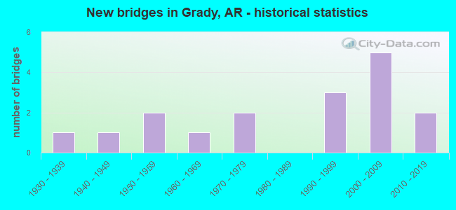
- New bridges - historical statistics
- 11930-1939
- 11940-1949
- 21950-1959
- 11960-1969
- 21970-1979
- 31990-1999
- 52000-2009
- 22010-2019

- Reconstructed bridges - Historical Statistics
- 11950-1959
- 01960-1969
- 11970-1979
- 01980-1989
- 21990-1999


- Bridge Condition - Deck
- 7.7%Excellent
- 23.1%Very good
- 38.5%Good
- 23.1%Satisfactory
- 7.7%Fair

- Bridge Condition - Superstructure
- 23.1%Very good
- 38.5%Good
- 23.1%Satisfactory
- 15.4%Fair

- Bridge Condition - Substructure
- 7.7%Excellent
- 15.4%Very good
- 46.2%Good
- 23.1%Satisfactory
- 7.7%Fair

- Bridge Condition - Channel
- 29.4%Very good
- 64.7%Good
- 5.9%Satisfactory

- Bridge Condition - Culverts
- 75.0%Very good
- 25.0%Good
Find on map >> Show street view
Structure Number: 1229, Location: 3.9 Mi S US 65-Grady (Lat: 34.034081, Lng: -91.709750), Route carried "on" structure: State highway 11, Year Built: 1949, Status: Open, Structure Length: 3.86m (12.66ft), Average Daily Traffic: 412 (year 2018), Truck Traffic: 1%, Average Future Daily Traffic: 708 (year 2028), Design Load: H 20, Features Intersected: Deep Bayou
Minimum Vertical Clearance: 30+ m (98+ ft), Kilometerpoint: 21.372, Lanes on structure: 2, Owner: State Highway Agency, Approaching Roadway Width: 7.6m (24.9ft), Material/Design: Steel, Design/Construction: Stringer/Multi-beam, Number Of Spans In Main Unit: 4, Length of Maximum Span: 9.8m (32.2ft), Curb or Sidewalk Widths: Left: 0.2m (0.7ft), Right: 0.2m (0.7ft), Curb-To-Curb Width: 8.1m (26.6ft), Out-to-Out Width: 8.4m (27.6ft)
Condition: Deck: Satisfactory, Superstructure: Satisfactory, Substructure: Fair, Channel: Good, Operating Rating: 49.0 metric tons, Method Used To Determine Operating Rating: Load Factor (LF), Inventory Rating: 29.0 metric tons, Method Used To Determine Inventory Rating: Load Factor (LF), Structural Evaluation: Somewhat better than minimum adequacy, Deck Geometry: Somewhat better than minimum adequacy, Waterway Adequacy: Equal to present minimum criteria, Approach Roadway Alignment: Equal to present desirable criteria, Length Of Structure Improvement: 3.84m (12.60ft), Designated Inspection Frequency: Every 24 months, Critical Feature Inspection Frequency: Every 24 months, Inspection Date: December 2021, Total Project Cost: $155,000, Deck Structure Type: Concrete Cast-file-Place, Wearing Surface/Protective System: Wearing Surface: Bituminous
Find on map >> Show street view
Structure Number: 3938, Location: 1.5 Mi E US 65-Grady (Lat: 34.093550, Lng: -91.663731), Route carried "on" structure: County highway 94, Year Built: 1965, Status: Open, Structure Length: 3.95m (12.96ft), Average Daily Traffic: 243 (year 2018), Truck Traffic: 1%, Average Future Daily Traffic: 78 (year 2007), Design Load: H 15, Features Intersected: Big Canal
Minimum Vertical Clearance: 30+ m (98+ ft), Kilometerpoint: 7.451, Lanes on structure: 2, Owner: County Highway Agency, Approaching Roadway Width: 7.3m (24.0ft), Skew: 3 degrees, Material/Design: Concrete, Design/Construction: Channel Beam, Number Of Spans In Main Unit: 6, Length of Maximum Span: 9.4m (30.8ft), Curb or Sidewalk Widths: Left: 0.2m (0.7ft), Right: 0.2m (0.7ft), Curb-To-Curb Width: 7.3m (24.0ft), Out-to-Out Width: 7.8m (25.6ft)
Condition: Deck: Good, Superstructure: Good, Substructure: Good, Channel: Good, Operating Rating: 37.2 metric tons, Method Used To Determine Operating Rating: Load Factor (LF), Inventory Rating: 21.8 metric tons, Method Used To Determine Inventory Rating: Load Factor (LF), Structural Evaluation: Equal to present minimum criteria, Deck Geometry: Somewhat better than minimum adequacy, Waterway Adequacy: Equal to present desirable criteria, Approach Roadway Alignment: Equal to present desirable criteria, Designated Inspection Frequency: Every 24 months, Critical Feature Inspection Frequency: Every 24 months, Inspection Date: September 2020, Deck Structure Type: Concrete Precast Panels, Wearing Surface/Protective System: Wearing Surface: Monolithic Concrete
Find on map >> Show street view
Structure Number: 6782, Location: 1.8 Mi S US 65-Grady (Lat: 34.054278, Lng: -91.706669), Route carried "on" structure: State highway 11, Year Built: 2001, Status: Open, Structure Length: 2.13m (6.99ft), Average Daily Traffic: 430 (year 2018), Truck Traffic: 1%, Average Future Daily Traffic: 708 (year 2028), Design Load: HS 20, Features Intersected: Wagon Bayou
Minimum Vertical Clearance: 30+ m (98+ ft), Kilometerpoint: 23.770, Lanes on structure: 2, Owner: State Highway Agency, Approaching Roadway Width: 7.9m (25.9ft), Material/Design: Steel, Design/Construction: Stringer/Multi-beam, Number Of Spans In Main Unit: 1, Length of Maximum Span: 19.8m (65.0ft), Curb-To-Curb Width: 9.1m (29.9ft), Out-to-Out Width: 10.1m (33.1ft)
Condition: Deck: Very good, Superstructure: Very good, Substructure: Good, Channel: Good, Operating Rating: 54.4 metric tons, Method Used To Determine Operating Rating: Load Factor (LF), Inventory Rating: 32.7 metric tons, Method Used To Determine Inventory Rating: Load Factor (LF), Structural Evaluation: Better than present minimum criteria, Deck Geometry: Equal to present minimum criteria, Waterway Adequacy: Equal to present minimum criteria, Approach Roadway Alignment: Equal to present minimum criteria, Designated Inspection Frequency: Every 24 months, Critical Feature Inspection Frequency: Every 24 months, Inspection Date: October 2020, Deck Structure Type: Concrete Cast-file-Place, Wearing Surface/Protective System: Wearing Surface: Monolithic Concrete
Find on map >> Show street view
Structure Number: 14614, Location: 0.7 Mi SW US 65 - Varner (Lat: 34.044872, Lng: -91.652911), Route carried "on" structure: County highway 36, Year Built: 1972, Year Reconstructed: 2002, Status: Open, Structure Length: 1.16m (3.81ft), Average Daily Traffic: 75 (year 2018), Truck Traffic: 1%, Average Future Daily Traffic: 183 (year 2007), Features Intersected: Canal
Minimum Vertical Clearance: 30+ m (98+ ft), Kilometerpoint: 6.019, Lanes on structure: 2, Owner: County Highway Agency, Approaching Roadway Width: 7.3m (24.0ft), Material/Design: Concrete, Design/Construction: Channel Beam, Number Of Spans In Main Unit: 2, Length of Maximum Span: 5.2m (17.1ft), Curb or Sidewalk Widths: Left: 0.2m (0.7ft), Right: 0.2m (0.7ft), Curb-To-Curb Width: 6.3m (20.7ft), Out-to-Out Width: 6.6m (21.7ft)
Condition: Deck: Good, Superstructure: Good, Substructure: Good, Channel: Good, Operating Rating: 40.8 metric tons, Method Used To Determine Operating Rating: Load Factor (LF), Inventory Rating: 24.5 metric tons, Method Used To Determine Inventory Rating: Load Factor (LF), Structural Evaluation: Equal to present minimum criteria, Deck Geometry: Somewhat better than minimum adequacy, Waterway Adequacy: Equal to present desirable criteria, Approach Roadway Alignment: Somewhat better than minimum adequacy, Designated Inspection Frequency: Every 24 months, Critical Feature Inspection Frequency: Every 24 months, Inspection Date: October 2021, Deck Structure Type: Concrete Precast Panels, Wearing Surface/Protective System: Wearing Surface: Monolithic Concrete
Find on map >> Show street view
Structure Number: 14644, Location: 3.3 Mi N US 65-Grady (Lat: 34.123119, Lng: -91.667661), Route carried "on" structure: County highway 95, Year Built: 1978, Year Reconstructed: 1999, Status: Posted for load, Structure Length: 1.34m (4.40ft), Average Daily Traffic: 50 (year 2018), Truck Traffic: 1%, Average Future Daily Traffic: 89 (year 2007), Features Intersected: Long Creek
Minimum Vertical Clearance: 30+ m (98+ ft), Kilometerpoint: 2.334, Lanes on structure: 1, Owner: County Highway Agency, Approaching Roadway Width: 6.7m (22.0ft), Material/Design: Steel, Design/Construction: Stringer/Multi-beam, Number Of Spans In Main Unit: 1, Length of Maximum Span: 12.5m (41.0ft), Curb-To-Curb Width: 4.9m (16.1ft), Out-to-Out Width: 4.9m (16.1ft)
Condition: Deck: Satisfactory, Superstructure: Satisfactory, Substructure: Good, Channel: Good, Operating Rating: 25.4 metric tons, Method Used To Determine Operating Rating: Load Factor (LF), Inventory Rating: 15.4 metric tons, Method Used To Determine Inventory Rating: Load Factor (LF), Structural Evaluation: Meets minimum limits, Deck Geometry: High priority of corrective action, Waterway Adequacy: Better than present minimum criteria, Approach Roadway Alignment: Equal to present desirable criteria, Bridge Posting: Required (Relationship of Operating Rating to Maximum Legal Load: 30.0 - 39.9% below), Length Of Structure Improvement: 2.07m (6.79ft), Designated Inspection Frequency: Every 24 months, Critical Feature Inspection Frequency: Every 24 months, Inspection Date: December 2021, Roadway Improvement Cost: $109,000, Total Project Cost: $234,000, Deck Structure Type: Wood or Timber, Wearing Surface/Protective System: Wearing Surface: Wood or Timber
Find on map >> Show street view
Structure Number: 20873, Location: 2.8 Mi S US 65-Grady (Lat: 34.032758, Lng: -91.683508), Route carried "on" structure: County highway 35, Year Built: 1990, Status: Open, Structure Length: 1.92m (6.30ft), Average Daily Traffic: 10 (year 2018), Truck Traffic: 1%, Average Future Daily Traffic: 134 (year 2007), Design Load: H 20, Features Intersected: Wagon Bayou
Minimum Vertical Clearance: 30+ m (98+ ft), Kilometerpoint: 1.223, Lanes on structure: 2, Owner: County Highway Agency, Approaching Roadway Width: 8.5m (27.9ft), Skew: 3 degrees, Material/Design: Concrete, Design/Construction: Culvert, Number Of Spans In Main Unit: 5, Length of Maximum Span: 3.4m (11.2ft)
Condition: Channel: Very good, Culverts: Very good, Operating Rating: 29.0 metric tons, Method Used To Determine Operating Rating: Load Factor (LF), Inventory Rating: 17.2 metric tons, Method Used To Determine Inventory Rating: Load Factor (LF), Structural Evaluation: Somewhat better than minimum adequacy, Waterway Adequacy: Equal to present desirable criteria, Approach Roadway Alignment: Equal to present desirable criteria, Designated Inspection Frequency: Every 48 months, Critical Feature Inspection Frequency: Every 24 months, Inspection Date: December 2020
Find on map >> Show street view
Structure Number: 2177, Location: 2.0 Mi N US 65-Tamo (Lat: 34.130369, Lng: -91.748778), Route carried "on" structure: County highway 42, Year Built: 1996, Status: Open, Structure Length: 1.95m (6.40ft), Average Daily Traffic: 319 (year 2018), Truck Traffic: 1%, Average Future Daily Traffic: 127 (year 2007), Features Intersected: Long Lake, Facility Carried by Structure: West Bitely Rd-CR
Minimum Vertical Clearance: 30+ m (98+ ft), Kilometerpoint: 5.906, Lanes on structure: 2, Owner: County Highway Agency, Approaching Roadway Width: 6.1m (20.0ft), Material/Design: Concrete, Design/Construction: Channel Beam, Number Of Spans In Main Unit: 2, Length of Maximum Span: 8.8m (28.9ft), Curb or Sidewalk Widths: Left: 0.3m (1.0ft), Right: 0.3m (1.0ft), Curb-To-Curb Width: 8.7m (28.5ft), Out-to-Out Width: 9.4m (30.8ft)
Condition: Deck: Very good, Superstructure: Very good, Substructure: Very good, Channel: Very good, Operating Rating: 46.3 metric tons, Method Used To Determine Operating Rating: Load Factor (LF), Inventory Rating: 28.1 metric tons, Method Used To Determine Inventory Rating: Load Factor (LF), Structural Evaluation: Better than present minimum criteria, Deck Geometry: Equal to present minimum criteria, Waterway Adequacy: Equal to present desirable criteria, Approach Roadway Alignment: Equal to present desirable criteria, Designated Inspection Frequency: Every 24 months, Critical Feature Inspection Frequency: Every 24 months, Inspection Date: October 2020, Deck Structure Type: Concrete Precast Panels, Wearing Surface/Protective System: Wearing Surface: Monolithic Concrete
Find on map >> Show street view
Structure Number: 22056, Location: 4.98 Mi S US 65-Tamo (Lat: 34.063519, Lng: -91.756608), Route carried "on" structure: County highway 26, Year Built: 1998, Status: Open, Structure Length: 2.90m (9.51ft), Average Daily Traffic: 40 (year 2018), Truck Traffic: 1%, Average Future Daily Traffic: 55 (year 2007), Features Intersected: Deep Bayou
Minimum Vertical Clearance: 30+ m (98+ ft), Kilometerpoint: 8.015, Lanes on structure: 2, Owner: County Highway Agency, Approaching Roadway Width: 5.5m (18.0ft), Material/Design: Concrete, Design/Construction: Channel Beam, Number Of Spans In Main Unit: 5, Length of Maximum Span: 5.8m (19.0ft), Curb or Sidewalk Widths: Left: 0.1m (0.3ft), Right: 0.1m (0.3ft), Curb-To-Curb Width: 5.2m (17.1ft), Out-to-Out Width: 5.5m (18.0ft)
Condition: Deck: Good, Superstructure: Good, Substructure: Good, Channel: Good, Operating Rating: 54.4 metric tons, Method Used To Determine Operating Rating: Load Factor (LF), Inventory Rating: 32.7 metric tons, Method Used To Determine Inventory Rating: Load Factor (LF), Structural Evaluation: Better than present minimum criteria, Deck Geometry: High priority of corrective action, Waterway Adequacy: Equal to present desirable criteria, Approach Roadway Alignment: Equal to present minimum criteria, Designated Inspection Frequency: Every 24 months, Critical Feature Inspection Frequency: Every 24 months, Inspection Date: September 2020, Deck Structure Type: Concrete Precast Panels, Wearing Surface/Protective System: Wearing Surface: Monolithic Concrete
Find on map >> Show street view
Structure Number: 22288, Location: 0.88 Mi W SH 11-Grady (Lat: 34.068658, Lng: -91.714969), Route carried "on" structure: County highway 26, Year Built: 2001, Status: Open, Structure Length: 1.74m (5.71ft), Average Daily Traffic: 42 (year 2018), Truck Traffic: 1%, Average Future Daily Traffic: 123 (year 2007), Features Intersected: Wagon Bayou
Minimum Vertical Clearance: 30+ m (98+ ft), Kilometerpoint: 1.416, Lanes on structure: 2, Owner: County Highway Agency, Approaching Roadway Width: 6.1m (20.0ft), Material/Design: Concrete, Design/Construction: Channel Beam, Number Of Spans In Main Unit: 3, Length of Maximum Span: 5.8m (19.0ft), Curb or Sidewalk Widths: Left: 0.2m (0.7ft), Right: 0.2m (0.7ft), Curb-To-Curb Width: 6.2m (20.3ft), Out-to-Out Width: 6.6m (21.7ft)
Condition: Deck: Good, Superstructure: Good, Substructure: Good, Channel: Very good, Operating Rating: 54.4 metric tons, Method Used To Determine Operating Rating: Load Factor (LF), Inventory Rating: 32.7 metric tons, Method Used To Determine Inventory Rating: Load Factor (LF), Structural Evaluation: Better than present minimum criteria, Deck Geometry: Somewhat better than minimum adequacy, Waterway Adequacy: Equal to present minimum criteria, Approach Roadway Alignment: Equal to present minimum criteria, Designated Inspection Frequency: Every 24 months, Critical Feature Inspection Frequency: Every 24 months, Inspection Date: September 2020, Deck Structure Type: Concrete Precast Panels, Wearing Surface/Protective System: Wearing Surface: Monolithic Concrete
Find on map >> Show street view
Structure Number: 22291, Location: 0.23 Mi S US 65-Tamo (Lat: 34.097228, Lng: -91.739908), Route carried "on" structure: County highway 416, Year Built: 2001, Status: Open, Structure Length: 1.95m (6.40ft), Average Daily Traffic: 2 (year 2018), Truck Traffic: 1%, Average Future Daily Traffic: 39 (year 2007), Features Intersected: Wagon Bayou
Minimum Vertical Clearance: 30+ m (98+ ft), Kilometerpoint: 0.370, Lanes on structure: 2, Owner: County Highway Agency, Approaching Roadway Width: 6.1m (20.0ft), Material/Design: Concrete, Design/Construction: Channel Beam, Number Of Spans In Main Unit: 2, Length of Maximum Span: 8.5m (27.9ft), Curb or Sidewalk Widths: Left: 0.3m (1.0ft), Right: 0.3m (1.0ft), Curb-To-Curb Width: 8.7m (28.5ft), Out-to-Out Width: 9.4m (30.8ft)
Condition: Deck: Very good, Superstructure: Very good, Substructure: Very good, Channel: Very good, Operating Rating: 46.3 metric tons, Method Used To Determine Operating Rating: Load Factor (LF), Inventory Rating: 28.1 metric tons, Method Used To Determine Inventory Rating: Load Factor (LF), Structural Evaluation: Better than present minimum criteria, Deck Geometry: Better than present minimum criteria, Waterway Adequacy: Equal to present desirable criteria, Approach Roadway Alignment: Equal to present desirable criteria, Designated Inspection Frequency: Every 24 months, Critical Feature Inspection Frequency: Every 24 months, Inspection Date: October 2020, Deck Structure Type: Concrete Precast Panels, Wearing Surface/Protective System: Wearing Surface: Monolithic Concrete
Find on map >> Show street view
Structure Number: 22929, Location: 0.5 Mi S JeffersonCo-Tamo (Lat: 34.087514, Lng: -91.771006), Route carried "on" structure: County highway 259, Year Built: 2006, Status: Posted for load, Structure Length: 2.72m (8.92ft), Average Daily Traffic: 17 (year 2018), Truck Traffic: 1%, Average Future Daily Traffic: 62 (year 2007), Features Intersected: Cousart Bayou
Minimum Vertical Clearance: 30+ m (98+ ft), Kilometerpoint: 0.772, Lanes on structure: 1, Owner: County Highway Agency, Approaching Roadway Width: 5.5m (18.0ft), Material/Design: Steel, Design/Construction: Orthotropic, Number Of Spans In Main Unit: 1, Length of Maximum Span: 25.3m (83.0ft), Curb-To-Curb Width: 5.1m (16.7ft), Out-to-Out Width: 5.4m (17.7ft)
Condition: Deck: Fair, Superstructure: Fair, Substructure: Satisfactory, Channel: Satisfactory, Operating Rating: 3.6 metric tons, Method Used To Determine Operating Rating: Load Factor (LF), Inventory Rating: 1.8 metric tons, Method Used To Determine Inventory Rating: Load Factor (LF), Structural Evaluation: High priority of corrective action, Deck Geometry: High priority of corrective action, Waterway Adequacy: Better than present minimum criteria, Approach Roadway Alignment: Better than present minimum criteria, Bridge Posting: Required (Relationship of Operating Rating to Maximum Legal Load: > 39.9% below), Designated Inspection Frequency: Every 24 months, Critical Feature Inspection Frequency: Every 24 months, Inspection Date: October 2021, Critical Feature Inspection Date: October 2021, Deck Structure Type: Steel plate
Find on map >> Show street view
Structure Number: 23867, Location: 0.8 Mi SW US 65-Tamo (Lat: 34.108889, Lng: -91.766550), Route carried "on" structure: County highway 19, Year Built: 2017, Status: Posted for load, Structure Length: 1.83m (6.00ft), Average Daily Traffic: 33 (year 2018), Truck Traffic: 1%, Average Future Daily Traffic: 40 (year 2037), Features Intersected: Jacks Bayou
Minimum Vertical Clearance: 30+ m (98+ ft), Kilometerpoint: 3.895, Lanes on structure: 2, Owner: County Highway Agency, Approaching Roadway Width: 4.9m (16.1ft), Material/Design: Steel, Design/Construction: Stringer/Multi-beam, Number Of Spans In Main Unit: 1, Length of Maximum Span: 18.0m (59.1ft), Curb-To-Curb Width: 5.5m (18.0ft), Out-to-Out Width: 5.5m (18.0ft)
Condition: Deck: Excellent, Superstructure: Good, Substructure: Excellent, Channel: Good, Operating Rating: 54.4 metric tons, Method Used To Determine Operating Rating: Load Factor (LF), Inventory Rating: 32.7 metric tons, Method Used To Determine Inventory Rating: Load Factor (LF), Structural Evaluation: Better than present minimum criteria, Waterway Adequacy: Equal to present desirable criteria, Approach Roadway Alignment: Equal to present desirable criteria, Designated Inspection Frequency: Every 24 months, Critical Feature Inspection Frequency: Every 24 months, Inspection Date: August 2021, Deck Structure Type: Concrete Cast-file-Place, Wearing Surface/Protective System: Wearing Surface: Monolithic Concrete
Find on map >> Show street view
Structure Number: M0342, Location: 3.3 Mi S US 65-Grady (Lat: 34.041839, Lng: -91.709789), Route carried "on" structure: State highway 11, Year Built: 1956, Status: Open, Structure Length: 0.84m (2.76ft), Average Daily Traffic: 412 (year 2018), Truck Traffic: 1%, Average Future Daily Traffic: 708 (year 2028), Design Load: H 15, Features Intersected: Canal
Minimum Vertical Clearance: 30+ m (98+ ft), Kilometerpoint: 22.225, Lanes on structure: 2, Owner: State Highway Agency, Approaching Roadway Width: 10.4m (34.1ft), Skew: 1 degrees, Material/Design: Concrete, Design/Construction: Culvert, Number Of Spans In Main Unit: 3, Length of Maximum Span: 2.4m (7.9ft)
Condition: Channel: Good, Culverts: Good, Operating Rating: 49.9 metric tons, Method Used To Determine Operating Rating: Load Factor (LF), Inventory Rating: 29.9 metric tons, Method Used To Determine Inventory Rating: Load Factor (LF), Structural Evaluation: Better than present minimum criteria, Waterway Adequacy: Better than present minimum criteria, Approach Roadway Alignment: Equal to present desirable criteria, Designated Inspection Frequency: Every 24 months, Critical Feature Inspection Frequency: Every 24 months, Inspection Date: October 2021
Find on map >> Show street view
Structure Number: M3974, Location: 1.0 Mi N US 65-Grady (Lat: 34.100169, Lng: -91.700369), Route carried "on" structure: State highway 11, Year Built: 1930, Year Reconstructed: 1950, Status: Open, Structure Length: 0.94m (3.08ft), Average Daily Traffic: 170 (year 2018), Truck Traffic: 1%, Average Future Daily Traffic: 348 (year 2028), Features Intersected: Canal
Minimum Vertical Clearance: 30+ m (98+ ft), Kilometerpoint: 29.354, Lanes on structure: 2, Owner: State Highway Agency, Approaching Roadway Width: 7.3m (24.0ft), Material/Design: Steel, Design/Construction: Stringer/Multi-beam, Number Of Spans In Main Unit: 1, Length of Maximum Span: 8.5m (27.9ft), Curb or Sidewalk Widths: Left: 0.2m (0.7ft), Right: 0.2m (0.7ft), Curb-To-Curb Width: 7.3m (24.0ft), Out-to-Out Width: 7.7m (25.3ft)
Condition: Deck: Good, Superstructure: Satisfactory, Substructure: Satisfactory, Channel: Good, Operating Rating: 39.0 metric tons, Method Used To Determine Operating Rating: Load Factor (LF), Inventory Rating: 23.6 metric tons, Method Used To Determine Inventory Rating: Load Factor (LF), Structural Evaluation: Equal to present minimum criteria, Deck Geometry: Somewhat better than minimum adequacy, Waterway Adequacy: Equal to present desirable criteria, Approach Roadway Alignment: Equal to present desirable criteria, Designated Inspection Frequency: Every 24 months, Critical Feature Inspection Frequency: Every 24 months, Inspection Date: December 2020, Deck Structure Type: Concrete Cast-file-Place, Wearing Surface/Protective System: Wearing Surface: Bituminous
Find on map >> Show street view
Structure Number: M3975, Location: 2.8 Mi N US 65-Grady (Lat: 34.122869, Lng: -91.691619), Route carried "on" structure: State highway 11, Year Built: 1950, Year Reconstructed: 1970, Status: Posted for load, Structure Length: 1.32m (4.33ft), Average Daily Traffic: 80 (year 2018), Truck Traffic: 1%, Average Future Daily Traffic: 149 (year 2028), Design Load: HS 20, Features Intersected: Long Lake
Minimum Vertical Clearance: 30+ m (98+ ft), Kilometerpoint: 32.332, Lanes on structure: 2, Owner: State Highway Agency, Approaching Roadway Width: 6.1m (20.0ft), Material/Design: Steel, Design/Construction: Stringer/Multi-beam, Number Of Spans In Main Unit: 1, Length of Maximum Span: 12.4m (40.7ft), Curb or Sidewalk Widths: Left: 0.2m (0.7ft), Right: 0.2m (0.7ft), Curb-To-Curb Width: 7.3m (24.0ft), Out-to-Out Width: 7.7m (25.3ft)
Condition: Deck: Satisfactory, Superstructure: Fair, Substructure: Satisfactory, Channel: Good, Operating Rating: 34.5 metric tons, Method Used To Determine Operating Rating: Load Factor (LF), Inventory Rating: 20.9 metric tons, Method Used To Determine Inventory Rating: Load Factor (LF), Structural Evaluation: Somewhat better than minimum adequacy, Deck Geometry: Equal to present minimum criteria, Waterway Adequacy: Somewhat better than minimum adequacy, Approach Roadway Alignment: Somewhat better than minimum adequacy, Bridge Posting: Required (Relationship of Operating Rating to Maximum Legal Load: 10.0 - 19.9% below), Designated Inspection Frequency: Every 24 months, Critical Feature Inspection Frequency: Every 24 months, Inspection Date: September 2021, Deck Structure Type: Concrete Cast-file-Place, Wearing Surface/Protective System: Wearing Surface: Bituminous
Find on map >> Show street view
Structure Number: X109, Location: 1.21 Mi N Lincoln Co-Tamo (Lat: 34.103339, Lng: -91.744861), Route carried "on" structure: US 65, Year Built: 2002, Status: Open, Structure Length: 1.82m (5.97ft), Average Daily Traffic: 6,785 (year 2018), Truck Traffic: 20%, Average Future Daily Traffic: 8,107 (year 2028), Design Load: H 20, Features Intersected: Wagon Bayou
Minimum Vertical Clearance: 30+ m (98+ ft), Kilometerpoint: 24.784, Lanes on structure: 4, Base Highway Network: Yes, Owner: State Highway Agency, Approaching Roadway Width: 24.4m (80.1ft), Skew: 14 degrees, Material/Design: Concrete, Design/Construction: Culvert, Number Of Spans In Main Unit: 5, Length of Maximum Span: 4.0m (13.1ft)
Condition: Channel: Good, Culverts: Very good, Operating Rating: 47.2 metric tons, Method Used To Determine Operating Rating: Load Factor (LF), Inventory Rating: 28.1 metric tons, Method Used To Determine Inventory Rating: Load Factor (LF), Structural Evaluation: Better than present minimum criteria, Waterway Adequacy: Equal to present desirable criteria, Approach Roadway Alignment: Equal to present desirable criteria, Designated Inspection Frequency: Every 24 months, Critical Feature Inspection Frequency: Every 24 months, Inspection Date: December 2021
Find on map >> Show street view
Structure Number: X1546, Location: 4.1 Mi N US 65-Grady (Lat: 34.133500, Lng: -91.687319), Route carried "on" structure: State highway 11, Year Built: 2019, Status: Open, Structure Length: 0.91m (2.99ft), Average Daily Traffic: 80 (year 2018), Truck Traffic: 1%, Average Future Daily Traffic: 70 (year 2038), Design Load: HL 93, Features Intersected: Canal
Minimum Vertical Clearance: 30+ m (98+ ft), Kilometerpoint: 33.845, Lanes on structure: 2, Owner: State Highway Agency, Approaching Roadway Width: 7.3m (24.0ft), Skew: 4 degrees, Material/Design: Concrete, Design/Construction: Culvert, Number Of Spans In Main Unit: 3, Length of Maximum Span: 3.0m (9.8ft)
Condition: Channel: Very good, Culverts: Very good, Operating Rating: 45.4 metric tons, Method Used To Determine Operating Rating: Load and Resistance Factor (LRFR), Inventory Rating: 32.7 metric tons, Method Used To Determine Inventory Rating: Load and Resistance Factor (LRFR), Structural Evaluation: Equal to present desirable criteria, Waterway Adequacy: Meets minimum limits, Approach Roadway Alignment: Equal to present desirable criteria, Designated Inspection Frequency: Every 24 months, Critical Feature Inspection Frequency: Every 24 months, Inspection Date: June 2021, Deck Structure Type: Concrete Cast-file-Place, Wearing Surface/Protective System: Wearing Surface: Bituminous