Bridge Statistics for Gowanda, New York (NY)
Condition, Traffic, Stress, Structural Evaluation, Project Costs
- National Bridge Inventory (NBI) Statistics
- 10Number of bridges
- 66ft / 20.0mTotal length
- $17,140,000Total costs
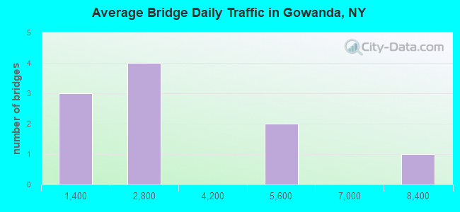
- 27,735Total average daily traffic
- 1,017Total average daily truck traffic
- National Bridge Inventory (NBI) Registered Bridges for Gowanda
- No street view available for this location
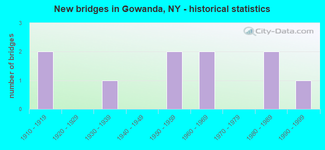
- New bridges - historical statistics
- 21910-1919
- 11930-1939
- 21950-1959
- 21960-1969
- 21980-1989
- 11990-1999
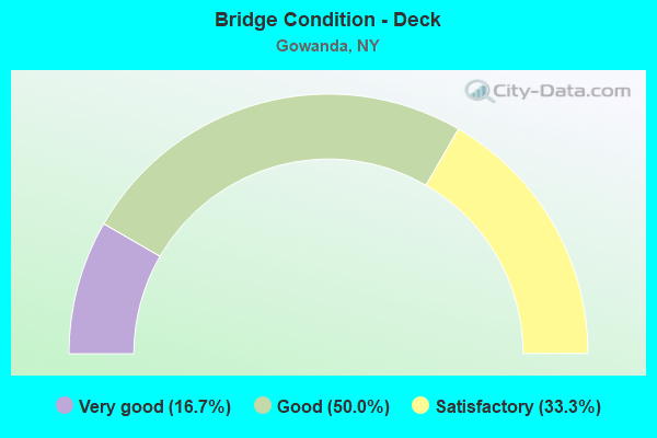
- Bridge Condition - Deck
- 16.7%Very good
- 50.0%Good
- 33.3%Satisfactory
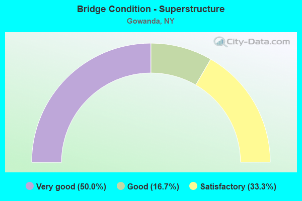
- Bridge Condition - Superstructure
- 50.0%Very good
- 16.7%Good
- 33.3%Satisfactory
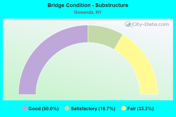
- Bridge Condition - Substructure
- 50.0%Good
- 16.7%Satisfactory
- 33.3%Fair
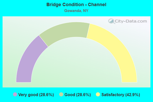
- Bridge Condition - Channel
- 28.6%Very good
- 28.6%Good
- 42.9%Satisfactory
Find on map >> Show street view
Structure Number: 102444, Location: 0.4MI W CATT.CREEK&RTE 39 (Lat: 42.461994, Lng: -78.942542), Route carried "on" structure: State highway 39, Year Built: 1987, Status: Open, Structure Length: 1.34m (4.40ft), Average Daily Traffic: 2,047 (year 2017), Truck Traffic: 9%, Average Future Daily Traffic: 2,161 (year 2040), Design Load: HS 20, Features Intersected: THATCHER BROOK
Minimum Vertical Clearance: 30+ m (98+ ft), Kilometerpoint: 10.201, Lanes on structure: 2, Base Highway Network: Yes, Owner: State Highway Agency, Approaching Roadway Width: 9.4m (30.8ft), Skew: 1 degrees, Material/Design: Prestressed concrete, Design/Construction: Box Beam or Girders - Multiple, Number Of Spans In Main Unit: 1, Length of Maximum Span: 12.8m (42.0ft), Curb or Sidewalk Widths: Left: 1.5m (4.9ft), Right: 1.5m (4.9ft), Curb-To-Curb Width: 9.4m (30.8ft), Out-to-Out Width: 13.2m (43.3ft)
Condition: Deck: Good, Superstructure: Very good, Substructure: Fair, Channel: Very good, Operating Rating: 76.2 metric tons, Method Used To Determine Operating Rating: Load Factor (LF), Inventory Rating: 37.2 metric tons, Method Used To Determine Inventory Rating: Load Factor (LF), Structural Evaluation: Somewhat better than minimum adequacy, Deck Geometry: Meets minimum limits, Waterway Adequacy: Equal to present minimum criteria, Approach Roadway Alignment: Equal to present desirable criteria, Length Of Structure Improvement: 1.34m (4.40ft), Designated Inspection Frequency: Every 24 months, Inspection Date: May 2021, Bridge Improvement Cost: $767,000, Roadway Improvement Cost: $449,000, Total Project Cost: $1,216,000 ( Estimate for 2021), Wearing Surface/Protective System: Wearing Surface: Monolithic Concrete
Find on map >> Show street view
Structure Number: 102445, Location: JCT RTE 39 + CATT CR. (Lat: 42.463383, Lng: -78.934800), Route carried "on" structure: US 62, Year Built: 1963, Status: Open, Structure Length: 3.90m (12.80ft), Average Daily Traffic: 8,007 (year 2019), Truck Traffic: 5%, Average Future Daily Traffic: 8,044 (year 2040), Design Load: HS 20, Features Intersected: CATTARAUGUS CREEK
Minimum Vertical Clearance: 30+ m (98+ ft), Kilometerpoint: 32.019, Lanes on structure: 4, Base Highway Network: Yes, Owner: State Highway Agency, Approaching Roadway Width: 15.2m (49.9ft), Skew: 1 degrees, Material/Design: Prestressed concrete, Design/Construction: Tee Beam, Number Of Spans In Main Unit: 1, Length of Maximum Span: 38.1m (125.0ft), Curb or Sidewalk Widths: Left: 2.1m (6.9ft), Right: 2.1m (6.9ft), Curb-To-Curb Width: 15.2m (49.9ft), Out-to-Out Width: 20.7m (67.9ft)
Condition: Deck: Satisfactory, Superstructure: Satisfactory, Substructure: Good, Channel: Very good, Inventory Rating: 61.7 metric tons, Method Used To Determine Inventory Rating: Load Factor (LF), Structural Evaluation: Equal to present minimum criteria, Deck Geometry: High priority of corrective action, Waterway Adequacy: Somewhat better than minimum adequacy, Approach Roadway Alignment: Equal to present desirable criteria, Length Of Structure Improvement: 3.90m (12.80ft), Designated Inspection Frequency: Every 24 months, Inspection Date: April 2021, Bridge Improvement Cost: $2,891,000, Roadway Improvement Cost: $1,693,000, Total Project Cost: $4,584,000 ( Estimate for 2021), Wearing Surface/Protective System: Wearing Surface: Bituminous, Membrane: Other
Find on map >> Show street view
Structure Number: 10281, Location: 0.3 MI S JCT CATT CR + 62 (Lat: 42.459308, Lng: -78.938031), Route carried "on" structure: US 62, Year Built: 1934, Year Reconstructed: 1997, Status: Open, Structure Length: 1.37m (4.49ft), Average Daily Traffic: 1,692 (year 2019), Truck Traffic: 13%, Average Future Daily Traffic: 1,699 (year 2040), Design Load: HS 25 or greater, Features Intersected: THATCHER BROOK
Minimum Vertical Clearance: 30+ m (98+ ft), Kilometerpoint: 31.504, Lanes on structure: 2, Base Highway Network: Yes, Owner: State Highway Agency, Approaching Roadway Width: 9.1m (29.9ft), Skew: 1 degrees, Material/Design: Prestressed concrete, Design/Construction: Box Beam or Girders - Multiple, Number Of Spans In Main Unit: 1, Length of Maximum Span: 12.8m (42.0ft), Curb or Sidewalk Widths: Left: 1.6m (5.2ft), Right: 1.6m (5.2ft), Curb-To-Curb Width: 9.1m (29.9ft), Out-to-Out Width: 12.9m (42.3ft)
Condition: Deck: Very good, Superstructure: Very good, Substructure: Satisfactory, Channel: Good, Operating Rating: 74.4 metric tons, Method Used To Determine Operating Rating: Load Factor (LF), Inventory Rating: 40.8 metric tons, Method Used To Determine Inventory Rating: Load Factor (LF), Structural Evaluation: Equal to present minimum criteria, Deck Geometry: Somewhat better than minimum adequacy, Waterway Adequacy: Somewhat better than minimum adequacy, Approach Roadway Alignment: Equal to present desirable criteria, Length Of Structure Improvement: 1.37m (4.49ft), Designated Inspection Frequency: Every 24 months, Inspection Date: May 2021, Bridge Improvement Cost: $730,000, Roadway Improvement Cost: $427,000, Total Project Cost: $1,157,000 ( Estimate for 2021), Wearing Surface/Protective System: Wearing Surface: Monolithic Concrete
Find on map >> Show street view
Structure Number: 332299, Location: AT GOWANDA (Lat: 42.455703, Lng: -78.939719), Route carried "on" structure: Other road , Year Built: 1968, Year Reconstructed: 1996, Status: Open, Structure Length: 0.91m (2.99ft), Average Daily Traffic: 446 (year 2017), Truck Traffic: 3%, Average Future Daily Traffic: 624 (year 2037), Design Load: H 20, Features Intersected: THATCHER BROOK, Facility Carried by Structure: HILL STREET
Minimum Vertical Clearance: 30+ m (98+ ft), Kilometerpoint: 0.451, Lanes on structure: 2, Owner: County Highway Agency, Approaching Roadway Width: 6.1m (20.0ft), Material/Design: Steel, Design/Construction: Stringer/Multi-beam, Number Of Spans In Main Unit: 1, Length of Maximum Span: 8.8m (28.9ft), Curb-To-Curb Width: 7.9m (25.9ft), Out-to-Out Width: 8.0m (26.2ft)
Condition: Deck: Satisfactory, Superstructure: Satisfactory, Substructure: Fair, Channel: Satisfactory, Operating Rating: 44.5 metric tons, Method Used To Determine Operating Rating: Load Factor (LF), Inventory Rating: 26.3 metric tons, Method Used To Determine Inventory Rating: Load Factor (LF), Structural Evaluation: Somewhat better than minimum adequacy, Deck Geometry: Somewhat better than minimum adequacy, Waterway Adequacy: Meets minimum limits, Approach Roadway Alignment: Meets minimum limits, Length Of Structure Improvement: 0.91m (2.99ft), Designated Inspection Frequency: Every 24 months, Inspection Date: August 2021, Bridge Improvement Cost: $1,139,000, Roadway Improvement Cost: $667,000, Total Project Cost: $1,806,000 ( Estimate for 2021), Deck Structure Type: Open Grating, Wearing Surface/Protective System: Wearing Surface: Other
Find on map >> Show street view
Structure Number: 3323, Location: AT GOWANDA ON JOHNSON ST (Lat: 42.461219, Lng: -78.941869), Route carried "on" structure: Other road , Year Built: 1995, Status: Open, Structure Length: 1.58m (5.18ft), Average Daily Traffic: 303 (year 2017), Truck Traffic: 4%, Average Future Daily Traffic: 424 (year 2037), Design Load: HS 25 or greater, Features Intersected: THATCHER BROOK, Facility Carried by Structure: JOHNSON STREET
Minimum Vertical Clearance: 30+ m (98+ ft), Kilometerpoint: 0.097, Lanes on structure: 2, Owner: County Highway Agency, Approaching Roadway Width: 8.8m (28.9ft), Skew: 4 degrees, Material/Design: Prestressed concrete, Design/Construction: Box Beam or Girders - Multiple, Number Of Spans In Main Unit: 1, Length of Maximum Span: 14.9m (48.9ft), Curb or Sidewalk Widths: Left: 1.6m (5.2ft), Right: 0.0m, Curb-To-Curb Width: 9.0m (29.5ft), Out-to-Out Width: 11.3m (37.1ft)
Condition: Deck: Good, Superstructure: Very good, Substructure: Good, Channel: Satisfactory, Operating Rating: 92.5 metric tons, Method Used To Determine Operating Rating: Load Factor (LF), Inventory Rating: 51.7 metric tons, Method Used To Determine Inventory Rating: Load Factor (LF), Structural Evaluation: Better than present minimum criteria, Deck Geometry: Equal to present minimum criteria, Waterway Adequacy: Somewhat better than minimum adequacy, Approach Roadway Alignment: Equal to present desirable criteria, Length Of Structure Improvement: 1.58m (5.18ft), Designated Inspection Frequency: Every 24 months, Inspection Date: August 2021, Bridge Improvement Cost: $725,000, Roadway Improvement Cost: $425,000, Total Project Cost: $1,149,000 ( Estimate for 2021), Deck Structure Type: Concrete Cast-file-Place, Wearing Surface/Protective System: Wearing Surface: Integral Concrete
Find on map >> Show street view
Structure Number: 332301, Location: IN VILLAGE OF GOWANDA (Lat: 42.460767, Lng: -78.938922), Route carried "on" structure: Other road , Year Built: 1987, Status: Open, Structure Length: 1.19m (3.90ft), Average Daily Traffic: 776 (year 2017), Truck Traffic: 5%, Average Future Daily Traffic: 1,086 (year 2037), Features Intersected: THATCHER BROOK, Facility Carried by Structure: S. CHAPEL STREET
Minimum Vertical Clearance: 30+ m (98+ ft), Kilometerpoint: 0.193, Lanes on structure: 2, Owner: County Highway Agency, Approaching Roadway Width: 7.3m (24.0ft), Skew: 4 degrees, Material/Design: Concrete, Design/Construction: Culvert, Number Of Spans In Main Unit: 1, Length of Maximum Span: 11.2m (36.7ft), Curb or Sidewalk Widths: Left: 1.2m (3.9ft), Right: 0.0m
Condition: Channel: Satisfactory, Culverts: Satisfactory, Operating Rating: 80.6 metric tons, Method Used To Determine Operating Rating: Field evaluation and documented engineering judgment, Inventory Rating: 32.7 metric tons, Method Used To Determine Inventory Rating: Field evaluation and documented engineering judgment, Structural Evaluation: Equal to present minimum criteria, Waterway Adequacy: Somewhat better than minimum adequacy, Approach Roadway Alignment: Equal to present desirable criteria, Length Of Structure Improvement: 1.18m (3.87ft), Designated Inspection Frequency: Every 24 months, Inspection Date: August 2021, Bridge Improvement Cost: $240,000, Roadway Improvement Cost: $141,000, Total Project Cost: $381,000 ( Estimate for 2021), Wearing Surface/Protective System: Wearing Surface: Bituminous
Find on map >> Show street view
Structure Number: 33283, Location: SOUTHWEST GOWANDA (Lat: 42.468650, Lng: -78.941603), Route carried "on" structure: County highway , Year Built: 1959, Year Reconstructed: 2002, Status: Open, Structure Length: 9.69m (31.79ft), Average Daily Traffic: 2,528 (year 2019), Truck Traffic: 6%, Average Future Daily Traffic: 3,539 (year 2039), Design Load: HS 25 or greater, Features Intersected: CATTARAUGUS CREEK, Facility Carried by Structure: ALDRICH STREET
Minimum Vertical Clearance: 30+ m (98+ ft), Kilometerpoint: 0.000, Lanes on structure: 2, Owner: County Highway Agency, Approaching Roadway Width: 10.1m (33.1ft), Material/Design: Steel continuous, Design/Construction: Stringer/Multi-beam, Number Of Spans In Main Unit: 3, Length of Maximum Span: 36.9m (121.1ft), Curb or Sidewalk Widths: Left: 1.5m (4.9ft), Right: 0.0m, Curb-To-Curb Width: 10.2m (33.5ft), Out-to-Out Width: 12.8m (42.0ft)
Condition: Deck: Good, Superstructure: Good, Substructure: Good, Channel: Good, Operating Rating: 80.7 metric tons, Method Used To Determine Operating Rating: Load Factor (LF), Inventory Rating: 49.9 metric tons, Method Used To Determine Inventory Rating: Load Factor (LF), Structural Evaluation: Better than present minimum criteria, Deck Geometry: Meets minimum limits, Waterway Adequacy: Equal to present desirable criteria, Approach Roadway Alignment: Equal to present desirable criteria, Length Of Structure Improvement: 9.69m (31.79ft), Designated Inspection Frequency: Every 24 months, Inspection Date: July 2021, Bridge Improvement Cost: $4,318,000, Roadway Improvement Cost: $2,529,000, Total Project Cost: $6,847,000 ( Estimate for 2021), Deck Structure Type: Concrete Cast-file-Place, Wearing Surface/Protective System: Wearing Surface: Integral Concrete, Deck Protection: Epoxy Coated Reinforcing
Find on map >> Show street view
Structure Number: 702447, Location: .1 MI E JCT US 62 & SH438 (Lat: 42.473753, Lng: -78.934592), Route carried "under" structure: State highway 39, Year Built: 1913, Structure Length: 0. m, Average Daily Traffic: 4,849 (year 1999), Features Intersected: RTE 39, RTE 62, Facility Carried by Structure: BUFFALO SOUTHERN
Minimum Vertical Clearance: 4.34m (14.24ft), Kilometerpoint: 1.271, Lanes under structure: 2, Material/Design: Steel, Design/Construction: Girder and Floorbeam System, Length of Maximum Span: 8.8m (28.9ft)
Find on map >> Show street view
Structure Number: 702447, Location: .1 MI E JCT US 62 & SH438 (Lat: 42.473753, Lng: -78.934592), Route carried "under" structure: US 62, Year Built: 1913, Structure Length: 0. m, Average Daily Traffic: 4,872 (year 1999), Features Intersected: RTE 39, RTE 62, Facility Carried by Structure: BUFFALO SOUTHERN
Minimum Vertical Clearance: 4.34m (14.24ft), Kilometerpoint: 1.271, Lanes under structure: 2, Material/Design: Steel, Design/Construction: Girder and Floorbeam System, Length of Maximum Span: 8.8m (28.9ft)
Find on map >> Show street view
Structure Number: 702809, Location: 0.8 MI S JCT CATT CR + 62 (Lat: 42.453881, Lng: -78.941511), Route carried "under" structure: US 62, Year Built: 1957, Structure Length: 0. m, Average Daily Traffic: 2,215 (year 1998), Features Intersected: RTE 62, Facility Carried by Structure: NY & LAKE ERIE
Minimum Vertical Clearance: 4.50m (14.76ft), Kilometerpoint: 30.941, Lanes under structure: 2, Material/Design: Steel, Design/Construction: Girder and Floorbeam System, Length of Maximum Span: 42.6m (139.8ft)