Bridge Statistics for Goreville, Illinois (IL)
Condition, Traffic, Stress, Structural Evaluation, Project Costs
- National Bridge Inventory (NBI) Statistics
- 35Number of bridges
- 479ft / 146mTotal length
- $148,000Total costs
- 288,825Total average daily traffic
- 102,023Total average daily truck traffic
- National Bridge Inventory (NBI) Registered Bridges for Goreville
- No street view available for this location
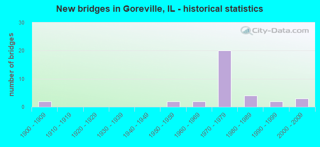
- New bridges - historical statistics
- 21900-1909
- 21950-1959
- 21960-1969
- 201970-1979
- 41980-1989
- 21990-1999
- 32000-2009

- Reconstructed bridges - Historical Statistics
- 11990-1999
- 02000-2009
- 12010-2019


- Bridge Condition - Deck
- 13.6%Very good
- 63.6%Good
- 13.6%Satisfactory
- 9.1%Fair

- Bridge Condition - Superstructure
- 9.1%Very good
- 40.9%Good
- 31.8%Satisfactory
- 18.2%Fair

- Bridge Condition - Substructure
- 45.5%Very good
- 40.9%Good
- 9.1%Satisfactory
- 4.5%Fair

- Bridge Condition - Channel
- 85.7%Very good
- 7.1%Good
- 7.1%Fair
Find on map >> Show street view
Structure Number: 440028, Location: 2.7 MI W GOREVILLE (Lat: 37.555928, Lng: -89.032853), Route carried "on" structure: County highway , Year Built: 1959, Year Reconstructed: 2001, Status: Open, Structure Length: 6.90m (22.64ft), Average Daily Traffic: 1,050 (year 2021), Truck Traffic: 12%, Average Future Daily Traffic: 925 (year 2032), Design Load: HS 20, Features Intersected: INTERSTATE 57, Facility Carried by Structure: FAS 1931
Minimum Vertical Clearance: 30+ m (98+ ft), Kilometerpoint: 0.113, Lanes on structure: 2, Lanes under structure: 4, Owner: State Highway Agency, Approaching Roadway Width: 11.3m (37.1ft), Skew: 3 degrees, Material/Design: Steel continuous, Design/Construction: Stringer/Multi-beam, Number Of Spans In Main Unit: 4, Length of Maximum Span: 19.7m (64.6ft), Curb-To-Curb Width: 9.8m (32.2ft), Out-to-Out Width: 10.8m (35.4ft)
Condition: Deck: Good, Superstructure: Satisfactory, Substructure: Very good, Operating Rating: 75.2 metric tons, Method Used To Determine Operating Rating: Load Factor (LF) rating reported by rating factor (RF) method using MS18 loading, Inventory Rating: 45.0 metric tons, Method Used To Determine Inventory Rating: Load Factor (LF) rating reported by rating factor (RF) method using MS18 loading, Structural Evaluation: Equal to present minimum criteria, Deck Geometry: Somewhat better than minimum adequacy, Underclear: Meets minimum limits, Approach Roadway Alignment: Equal to present desirable criteria, Designated Inspection Frequency: Every 24 months, Inspection Date: April 2020, Deck Structure Type: Concrete Cast-file-Place, Wearing Surface/Protective System: Deck Protection: Epoxy Coated Reinforcing
Find on map >> Show street view
Structure Number: 440029, Location: 1.7 MI SE I-57 (Lat: 37.593831, Lng: -88.984539), Route carried "on" structure: Interstate 24, Year Built: 1972, Status: Open, Structure Length: 21.34m (70.01ft), Average Daily Traffic: 11,500 (year 2021), Truck Traffic: 35%, Average Future Daily Traffic: 8,976 (year 2032), Design Load: HS 20+Mod, Features Intersected: TR 42 & L SALINE R
Minimum Vertical Clearance: 30+ m (98+ ft), Kilometerpoint: 2.961, Lanes on structure: 2, Lanes under structure: 2, Base Highway Network: Yes, Owner: State Highway Agency, Approaching Roadway Width: 12.2m (40.0ft), Material/Design: Steel continuous, Design/Construction: Stringer/Multi-beam, Number Of Spans In Main Unit: 5, Length of Maximum Span: 58.8m (192.9ft), Curb-To-Curb Width: 11.7m (38.4ft), Out-to-Out Width: 12.7m (41.7ft)
Condition: Deck: Satisfactory, Superstructure: Satisfactory, Substructure: Satisfactory, Channel: Very good, Operating Rating: 66.1 metric tons, Method Used To Determine Operating Rating: Load Factor (LF) rating reported by rating factor (RF) method using MS18 loading, Inventory Rating: 39.5 metric tons, Method Used To Determine Inventory Rating: Load Factor (LF) rating reported by rating factor (RF) method using MS18 loading, Structural Evaluation: Equal to present minimum criteria, Deck Geometry: Equal to present minimum criteria, Underclear: Meets minimum limits, Waterway Adequacy: Superior to present desirable criteria, Approach Roadway Alignment: Equal to present desirable criteria, Designated Inspection Frequency: Every 24 months, Inspection Date: March 2020, Deck Structure Type: Concrete Cast-file-Place, Wearing Surface/Protective System: Wearing Surface: Other
Find on map >> Show street view
Structure Number: 44003, Location: 1.7 MI SE I-57 (Lat: 37.593725, Lng: -88.984389), Route carried "on" structure: Interstate 24, Year Built: 1972, Status: Open, Structure Length: 21.34m (70.01ft), Average Daily Traffic: 11,500 (year 2021), Truck Traffic: 35%, Average Future Daily Traffic: 8,976 (year 2032), Design Load: HS 20+Mod, Features Intersected: TR 42 & L SALINE R
Minimum Vertical Clearance: 30+ m (98+ ft), Kilometerpoint: 2.977, Lanes on structure: 2, Lanes under structure: 2, Base Highway Network: Yes, Owner: State Highway Agency, Approaching Roadway Width: 12.2m (40.0ft), Material/Design: Steel continuous, Design/Construction: Stringer/Multi-beam, Number Of Spans In Main Unit: 5, Length of Maximum Span: 58.8m (192.9ft), Curb-To-Curb Width: 11.7m (38.4ft), Out-to-Out Width: 12.7m (41.7ft)
Condition: Deck: Good, Superstructure: Satisfactory, Substructure: Satisfactory, Channel: Very good, Operating Rating: 66.1 metric tons, Method Used To Determine Operating Rating: Load Factor (LF) rating reported by rating factor (RF) method using MS18 loading, Inventory Rating: 39.5 metric tons, Method Used To Determine Inventory Rating: Load Factor (LF) rating reported by rating factor (RF) method using MS18 loading, Structural Evaluation: Equal to present minimum criteria, Deck Geometry: Equal to present minimum criteria, Underclear: Meets minimum limits, Waterway Adequacy: Superior to present desirable criteria, Approach Roadway Alignment: Equal to present desirable criteria, Designated Inspection Frequency: Every 24 months, Inspection Date: March 2020, Deck Structure Type: Concrete Cast-file-Place, Wearing Surface/Protective System: Wearing Surface: Other
Find on map >> Show street view
Structure Number: 440031, Location: 1.5 MI N GOREVILLE (Lat: 37.584189, Lng: -88.969369), Route carried "on" structure: State highway 37, Year Built: 1972, Status: Open, Structure Length: 10.02m (32.87ft), Average Daily Traffic: 4,300 (year 2021), Truck Traffic: 8%, Average Future Daily Traffic: 4,352 (year 2032), Design Load: HS 20, Features Intersected: INTERSTATE 24
Minimum Vertical Clearance: 30+ m (98+ ft), Kilometerpoint: 69.602, Lanes on structure: 2, Lanes under structure: 4, Base Highway Network: Yes, Owner: State Highway Agency, Approaching Roadway Width: 10.4m (34.1ft), Skew: 3 degrees, Material/Design: Steel continuous, Design/Construction: Stringer/Multi-beam, Number Of Spans In Main Unit: 2, Number Of Approach Spans: 2, Length of Maximum Span: 37.9m (124.3ft), Curb-To-Curb Width: 13.0m (42.7ft), Out-to-Out Width: 13.9m (45.6ft)
Condition: Deck: Good, Superstructure: Satisfactory, Substructure: Good, Operating Rating: 48.0 metric tons, Method Used To Determine Operating Rating: Load Factor (LF) rating reported by rating factor (RF) method using MS18 loading, Inventory Rating: 28.8 metric tons, Method Used To Determine Inventory Rating: Load Factor (LF) rating reported by rating factor (RF) method using MS18 loading, Structural Evaluation: Equal to present minimum criteria, Deck Geometry: Equal to present minimum criteria, Underclear: Somewhat better than minimum adequacy, Approach Roadway Alignment: Equal to present desirable criteria, Designated Inspection Frequency: Every 24 months, Other Special Inspection Frequency: Every 48 months, Inspection Date: January 2022, Other Special Inspection Date: December 2018, Deck Structure Type: Concrete Cast-file-Place, Wearing Surface/Protective System: Wearing Surface: Other
Find on map >> Show street view
Structure Number: 440033, Location: 0.5 MI E OF ILL. 37 (Lat: 37.579847, Lng: -88.964439), Route carried "on" structure: County highway , Year Built: 1972, Status: Open, Structure Length: 9.44m (30.97ft), Average Daily Traffic: 1,150 (year 2021), Truck Traffic: 7%, Average Future Daily Traffic: 1,088 (year 2032), Design Load: HS 15, Features Intersected: INTERSTATE 24, Facility Carried by Structure: TR 15 EAGLE PT BAY
Minimum Vertical Clearance: 30+ m (98+ ft), Kilometerpoint: 0.435, Lanes on structure: 2, Lanes under structure: 4, Owner: State Highway Agency, Approaching Roadway Width: 6.1m (20.0ft), Skew: 3 degrees, Material/Design: Steel continuous, Design/Construction: Stringer/Multi-beam, Number Of Spans In Main Unit: 2, Number Of Approach Spans: 2, Length of Maximum Span: 39.9m (130.9ft), Curb-To-Curb Width: 8.1m (26.6ft), Out-to-Out Width: 9.1m (29.9ft)
Condition: Deck: Good, Superstructure: Good, Substructure: Good, Operating Rating: 74.5 metric tons, Method Used To Determine Operating Rating: Load Factor (LF) rating reported by rating factor (RF) method using MS18 loading, Inventory Rating: 44.7 metric tons, Method Used To Determine Inventory Rating: Load Factor (LF) rating reported by rating factor (RF) method using MS18 loading, Structural Evaluation: Better than present minimum criteria, Deck Geometry: Meets minimum limits, Underclear: Somewhat better than minimum adequacy, Approach Roadway Alignment: Equal to present desirable criteria, Designated Inspection Frequency: Every 24 months, Inspection Date: January 2022, Deck Structure Type: Concrete Cast-file-Place, Wearing Surface/Protective System: Wearing Surface: Gravel
Find on map >> Show street view
Structure Number: 440034, Location: 2.5 MI E OF ILL 37 (Lat: 37.555656, Lng: -88.943125), Route carried "on" structure: County highway , Year Built: 1972, Status: Open, Structure Length: 9.91m (32.51ft), Average Daily Traffic: 275 (year 2021), Truck Traffic: 8%, Average Future Daily Traffic: 354 (year 2032), Design Load: HS 15, Features Intersected: INTERSTATE 24, Facility Carried by Structure: TR 82 DEER RIDGE R
Minimum Vertical Clearance: 30+ m (98+ ft), Kilometerpoint: 2.768, Lanes on structure: 2, Lanes under structure: 4, Owner: State Highway Agency, Approaching Roadway Width: 5.5m (18.0ft), Skew: 3 degrees, Material/Design: Steel continuous, Design/Construction: Stringer/Multi-beam, Number Of Spans In Main Unit: 4, Length of Maximum Span: 36.3m (119.1ft), Curb-To-Curb Width: 8.1m (26.6ft), Out-to-Out Width: 9.2m (30.2ft)
Condition: Deck: Good, Superstructure: Satisfactory, Substructure: Good, Operating Rating: 58.6 metric tons, Method Used To Determine Operating Rating: Load Factor (LF) rating reported by rating factor (RF) method using MS18 loading, Inventory Rating: 35.3 metric tons, Method Used To Determine Inventory Rating: Load Factor (LF) rating reported by rating factor (RF) method using MS18 loading, Structural Evaluation: Equal to present minimum criteria, Deck Geometry: Somewhat better than minimum adequacy, Underclear: Somewhat better than minimum adequacy, Approach Roadway Alignment: Equal to present desirable criteria, Designated Inspection Frequency: Every 24 months, Inspection Date: Febuary 2022, Deck Structure Type: Concrete Cast-file-Place, Wearing Surface/Protective System: Wearing Surface: Gravel
Find on map >> Show street view
Structure Number: 440035, Location: GOREVILLE INTERCH. (Lat: 37.533447, Lng: -88.924022), Route carried "on" structure: County highway , Year Built: 1971, Status: Open, Structure Length: 8.90m (29.20ft), Average Daily Traffic: 1,700 (year 2021), Truck Traffic: 8%, Average Future Daily Traffic: 1,523 (year 2032), Design Load: HS 15, Features Intersected: INTERSTATE 24, Facility Carried by Structure: FAS 927 TUNNEL HIL
Minimum Vertical Clearance: 30+ m (98+ ft), Kilometerpoint: 4.152, Lanes on structure: 2, Lanes under structure: 4, Owner: State Highway Agency, Approaching Roadway Width: 7.3m (24.0ft), Skew: 3 degrees, Material/Design: Steel continuous, Design/Construction: Stringer/Multi-beam, Number Of Spans In Main Unit: 2, Number Of Approach Spans: 2, Length of Maximum Span: 37.1m (121.7ft), Curb-To-Curb Width: 8.7m (28.5ft), Out-to-Out Width: 9.7m (31.8ft)
Condition: Deck: Very good, Superstructure: Fair, Substructure: Good, Operating Rating: 48.9 metric tons, Method Used To Determine Operating Rating: Load Factor (LF) rating reported by rating factor (RF) method using MS18 loading, Inventory Rating: 29.5 metric tons, Method Used To Determine Inventory Rating: Load Factor (LF) rating reported by rating factor (RF) method using MS18 loading, Structural Evaluation: Somewhat better than minimum adequacy, Deck Geometry: Somewhat better than minimum adequacy, Underclear: Somewhat better than minimum adequacy, Approach Roadway Alignment: Equal to present desirable criteria, Designated Inspection Frequency: Every 24 months, Inspection Date: October 2020, Deck Structure Type: Concrete Cast-file-Place, Wearing Surface/Protective System: Wearing Surface: Bituminous, Membrane: Built-up
Find on map >> Show street view
Structure Number: 440036, Location: 6.5 MI S.E. OF ILL37 (Lat: 37.515903, Lng: -88.909733), Route carried "on" structure: County highway , Year Built: 1972, Status: Open, Structure Length: 8.40m (27.56ft), Average Daily Traffic: 175 (year 2021), Truck Traffic: 30%, Average Future Daily Traffic: 490 (year 2032), Design Load: HS 15, Features Intersected: INTERSTATE 24, Facility Carried by Structure: TR 96 DUTCHMAN LAK
Minimum Vertical Clearance: 30+ m (98+ ft), Kilometerpoint: 2.398, Lanes on structure: 2, Lanes under structure: 4, Owner: State Highway Agency, Approaching Roadway Width: 5.5m (18.0ft), Skew: 2 degrees, Material/Design: Steel continuous, Design/Construction: Stringer/Multi-beam, Number Of Spans In Main Unit: 2, Number Of Approach Spans: 2, Length of Maximum Span: 34.4m (112.9ft), Curb-To-Curb Width: 8.1m (26.6ft), Out-to-Out Width: 9.1m (29.9ft)
Condition: Deck: Good, Superstructure: Satisfactory, Substructure: Good, Operating Rating: 55.4 metric tons, Method Used To Determine Operating Rating: Load Factor (LF) rating reported by rating factor (RF) method using MS18 loading, Inventory Rating: 33.4 metric tons, Method Used To Determine Inventory Rating: Load Factor (LF) rating reported by rating factor (RF) method using MS18 loading, Structural Evaluation: Equal to present minimum criteria, Deck Geometry: Somewhat better than minimum adequacy, Underclear: Somewhat better than minimum adequacy, Approach Roadway Alignment: Equal to present minimum criteria, Designated Inspection Frequency: Every 24 months, Inspection Date: January 2022, Deck Structure Type: Concrete Cast-file-Place, Wearing Surface/Protective System: Wearing Surface: Gravel
Find on map >> Show street view
Structure Number: 442005, Location: 1.88M E OF ILL 37 (Lat: 37.562464, Lng: -88.949147), Route carried "on" structure: Interstate 24, Year Built: 1976, Status: Open, Structure Length: 0.67m (2.20ft), Average Daily Traffic: 23,000 (year 2021), Truck Traffic: 35%, Average Future Daily Traffic: 17,952 (year 2032), Design Load: HS 20+Mod, Features Intersected: DRY FORK CREEK
Minimum Vertical Clearance: 30+ m (98+ ft), Kilometerpoint: 7.692, Lanes on structure: 4, Base Highway Network: Yes, Owner: State Highway Agency, Approaching Roadway Width: 25.6m (84.0ft), Skew: 20 degrees, Material/Design: Concrete continuous, Design/Construction: Culvert, Number Of Spans In Main Unit: 2, Length of Maximum Span: 3.0m (9.8ft)
Condition: Channel: Fair, Culverts: Satisfactory, Operating Rating: 89.1 metric tons, Method Used To Determine Operating Rating: Load Factor (LF) rating reported by rating factor (RF) method using MS18 loading, Inventory Rating: 89.1 metric tons, Method Used To Determine Inventory Rating: Load Factor (LF) rating reported by rating factor (RF) method using MS18 loading, Structural Evaluation: Equal to present minimum criteria, Waterway Adequacy: Superior to present desirable criteria, Approach Roadway Alignment: Equal to present desirable criteria, Designated Inspection Frequency: Every 24 months, Inspection Date: January 2021
Find on map >> Show street view
Structure Number: 443074, Location: SE1/4 SEC 9 T11S,R2E (Lat: 37.574894, Lng: -88.985503), Route carried "on" structure: County highway , Year Built: 1982, Status: Open, Structure Length: 2.04m (6.69ft), Average Daily Traffic: 50 (year 2021), Truck Traffic: 2%, Average Future Daily Traffic: 54 (year 2032), Design Load: HS 20, Features Intersected: LITTLE SALINE CREEK, Facility Carried by Structure: TR 13
Minimum Vertical Clearance: 30+ m (98+ ft), Kilometerpoint: 2.559, Lanes on structure: 2, Owner: Town or Township Highway Agency, Approaching Roadway Width: 5.5m (18.0ft), Skew: 2 degrees, Material/Design: Concrete, Design/Construction: Channel Beam, Number Of Spans In Main Unit: 3, Length of Maximum Span: 6.7m (22.0ft), Curb-To-Curb Width: 7.8m (25.6ft), Out-to-Out Width: 8.0m (26.2ft)
Condition: Deck: Good, Superstructure: Good, Substructure: Very good, Channel: Very good, Operating Rating: 44.4 metric tons, Method Used To Determine Operating Rating: Assigned rating based on Load Factor Design (LFD) reported by rating factor (RF) using MS18 loading, Inventory Rating: 32.4 metric tons, Method Used To Determine Inventory Rating: Assigned rating based on Load Factor Design (LFD) reported by rating factor (RF) using MS18 loading, Structural Evaluation: Better than present minimum criteria, Deck Geometry: Equal to present minimum criteria, Waterway Adequacy: Better than present minimum criteria, Approach Roadway Alignment: Better than present minimum criteria, Designated Inspection Frequency: Every 48 months, Inspection Date: January 2022, Deck Structure Type: Concrete Precast Panels, Wearing Surface/Protective System: Wearing Surface: Gravel
Find on map >> Show street view
Structure Number: 443097, Location: NW1/4 SEC11 T11S,R2E (Lat: 37.580081, Lng: -88.956372), Route carried "on" structure: County highway , Year Built: 1985, Status: Open, Structure Length: 0.79m (2.59ft), Average Daily Traffic: 1,150 (year 2021), Truck Traffic: 7%, Average Future Daily Traffic: 1,088 (year 2032), Design Load: HS 20, Features Intersected: CLIFTY CREEK, Facility Carried by Structure: TR 15
Minimum Vertical Clearance: 30+ m (98+ ft), Kilometerpoint: 1.143, Lanes on structure: 2, Owner: Town or Township Highway Agency, Approaching Roadway Width: 6.7m (22.0ft), Material/Design: Prestressed concrete, Design/Construction: Box Beam or Girders - Multiple, Number Of Spans In Main Unit: 1, Length of Maximum Span: 7.6m (24.9ft), Curb-To-Curb Width: 9.2m (30.2ft), Out-to-Out Width: 9.2m (30.2ft)
Condition: Deck: Good, Superstructure: Good, Substructure: Very good, Channel: Good, Operating Rating: 44.4 metric tons, Method Used To Determine Operating Rating: Assigned rating based on Load Factor Design (LFD) reported by rating factor (RF) using MS18 loading, Inventory Rating: 32.4 metric tons, Method Used To Determine Inventory Rating: Assigned rating based on Load Factor Design (LFD) reported by rating factor (RF) using MS18 loading, Structural Evaluation: Better than present minimum criteria, Deck Geometry: Somewhat better than minimum adequacy, Waterway Adequacy: Better than present minimum criteria, Approach Roadway Alignment: Equal to present desirable criteria, Designated Inspection Frequency: Every 48 months, Inspection Date: Febuary 2019, Deck Structure Type: Concrete Precast Panels, Wearing Surface/Protective System: Wearing Surface: Gravel
Find on map >> Show street view
Structure Number: 4431, Location: SW1/4 SEC29 T11S,R3E (Lat: 37.531731, Lng: -88.906728), Route carried "on" structure: County highway , Year Built: 1986, Status: Open, Structure Length: 1.89m (6.20ft), Average Daily Traffic: 175 (year 2021), Truck Traffic: 30%, Average Future Daily Traffic: 490 (year 2032), Design Load: HS 20, Features Intersected: TRIB CACHECREEK, Facility Carried by Structure: TR 96
Minimum Vertical Clearance: 30+ m (98+ ft), Kilometerpoint: 0.515, Lanes on structure: 2, Owner: Town or Township Highway Agency, Approaching Roadway Width: 6.1m (20.0ft), Skew: 4 degrees, Material/Design: Prestressed concrete, Design/Construction: Box Beam or Girders - Multiple, Number Of Spans In Main Unit: 1, Length of Maximum Span: 17.7m (58.1ft), Curb-To-Curb Width: 7.4m (24.3ft), Out-to-Out Width: 7.4m (24.3ft)
Condition: Deck: Good, Superstructure: Good, Substructure: Good, Channel: Very good, Operating Rating: 44.4 metric tons, Method Used To Determine Operating Rating: Assigned rating based on Load Factor Design (LFD) reported by rating factor (RF) using MS18 loading, Inventory Rating: 32.4 metric tons, Method Used To Determine Inventory Rating: Assigned rating based on Load Factor Design (LFD) reported by rating factor (RF) using MS18 loading, Structural Evaluation: Better than present minimum criteria, Deck Geometry: Somewhat better than minimum adequacy, Waterway Adequacy: Better than present minimum criteria, Approach Roadway Alignment: Equal to present desirable criteria, Designated Inspection Frequency: Every 48 months, Inspection Date: January 2021, Deck Structure Type: Concrete Precast Panels, Wearing Surface/Protective System: Wearing Surface: Gravel
Find on map >> Show street view
Structure Number: 443106, Location: NE1/4 SEC32 T11S R2E (Lat: 37.521975, Lng: -89.006983), Route carried "on" structure: County highway , Year Built: 1990, Status: Open, Structure Length: 1.57m (5.15ft), Average Daily Traffic: 50 (year 2021), Truck Traffic: 6%, Average Future Daily Traffic: 299 (year 2032), Design Load: HS 20, Features Intersected: BUCK BRANCH CR, Facility Carried by Structure: TR 38
Minimum Vertical Clearance: 30+ m (98+ ft), Kilometerpoint: 3.862, Lanes on structure: 2, Owner: Town or Township Highway Agency, Approaching Roadway Width: 6.1m (20.0ft), Skew: 1 degrees, Material/Design: Prestressed concrete, Design/Construction: Box Beam or Girders - Multiple, Number Of Spans In Main Unit: 1, Length of Maximum Span: 14.9m (48.9ft), Curb-To-Curb Width: 7.4m (24.3ft), Out-to-Out Width: 7.4m (24.3ft)
Condition: Deck: Good, Superstructure: Good, Substructure: Very good, Channel: Very good, Operating Rating: 44.4 metric tons, Method Used To Determine Operating Rating: Assigned rating based on Load Factor Design (LFD) reported by rating factor (RF) using MS18 loading, Inventory Rating: 32.4 metric tons, Method Used To Determine Inventory Rating: Assigned rating based on Load Factor Design (LFD) reported by rating factor (RF) using MS18 loading, Structural Evaluation: Better than present minimum criteria, Deck Geometry: Equal to present minimum criteria, Waterway Adequacy: Equal to present minimum criteria, Approach Roadway Alignment: Equal to present minimum criteria, Designated Inspection Frequency: Every 48 months, Inspection Date: January 2020, Deck Structure Type: Concrete Precast Panels, Wearing Surface/Protective System: Wearing Surface: Gravel
Find on map >> Show street view
Structure Number: 443116, Location: NW1/4 SEC36 T11S,R2E (Lat: 37.521417, Lng: -88.940292), Route carried "on" structure: County highway , Year Built: 2003, Status: Open, Structure Length: 1.87m (6.14ft), Average Daily Traffic: 75 (year 2021), Truck Traffic: 9%, Average Future Daily Traffic: 190 (year 2032), Design Load: HS 20, Features Intersected: DUTCHMAN CREEK, Facility Carried by Structure: TR 67
Minimum Vertical Clearance: 30+ m (98+ ft), Kilometerpoint: 2.446, Lanes on structure: 2, Owner: Town or Township Highway Agency, Approaching Roadway Width: 6.1m (20.0ft), Material/Design: Prestressed concrete, Design/Construction: Box Beam or Girders - Multiple, Number Of Spans In Main Unit: 1, Length of Maximum Span: 18.1m (59.4ft), Curb-To-Curb Width: 7.4m (24.3ft), Out-to-Out Width: 7.4m (24.3ft)
Condition: Deck: Good, Superstructure: Good, Substructure: Very good, Channel: Very good, Operating Rating: 44.1 metric tons, Method Used To Determine Operating Rating: Assigned rating based on Load Factor Design (LFD) reported by rating factor (RF) using MS18 loading, Inventory Rating: 32.4 metric tons, Method Used To Determine Inventory Rating: Assigned rating based on Load Factor Design (LFD) reported by rating factor (RF) using MS18 loading, Structural Evaluation: Better than present minimum criteria, Deck Geometry: Equal to present minimum criteria, Waterway Adequacy: Better than present minimum criteria, Approach Roadway Alignment: Equal to present desirable criteria, Designated Inspection Frequency: Every 48 months, Inspection Date: January 2020, Deck Structure Type: Concrete Precast Panels
Find on map >> Show street view
Structure Number: 449905, Location: GOREVILLE E.ILL 37 (Lat: 37.546489, Lng: -88.968814), Route carried "on" structure: City street , Year Built: 1900, Status: Posted for load, Structure Length: 2.13m (6.99ft), Average Daily Traffic: 25 (year 2021), Truck Traffic: 4%, Average Future Daily Traffic: 109 (year 2032), Features Intersected: UNION PACIFIC RR, Facility Carried by Structure: SIDE STREET
Minimum Vertical Clearance: 30+ m (98+ ft), Kilometerpoint: 0.805, Lanes on structure: 1, Owner: Railroad, Approaching Roadway Width: 4.9m (16.1ft), Material/Design: Wood or Timber, Design/Construction: Stringer/Multi-beam, Number Of Spans In Main Unit: 3, Length of Maximum Span: 7.3m (24.0ft), Curb-To-Curb Width: 4.3m (14.1ft), Out-to-Out Width: 4.5m (14.8ft)
Condition: Deck: Fair, Superstructure: Fair, Substructure: Fair, Operating Rating: 18.5 metric tons, Method Used To Determine Operating Rating: Load Factor (LF) rating reported by rating factor (RF) method using MS18 loading, Inventory Rating: 13.0 metric tons, Method Used To Determine Inventory Rating: Load Factor (LF) rating reported by rating factor (RF) method using MS18 loading, Structural Evaluation: Meets minimum limits, Deck Geometry: Equal to present minimum criteria, Underclear: Somewhat better than minimum adequacy, Approach Roadway Alignment: Equal to present minimum criteria, Bridge Posting: Required (Relationship of Operating Rating to Maximum Legal Load: 30.0 - 39.9% below), Length Of Structure Improvement: 2.77m (9.09ft), Designated Inspection Frequency: Every 24 months, Inspection Date: August 2021, Bridge Improvement Cost: $98,000, Roadway Improvement Cost: $10,000, Total Project Cost: $148,000, Deck Structure Type: Wood or Timber, Wearing Surface/Protective System: Wearing Surface: Wood or Timber
Find on map >> Show street view
Structure Number: 1000059, Location: PULLEY'S MILL INTER (Lat: 37.610031, Lng: -88.994511), Route carried "on" structure: Other road , Year Built: 1972, Status: Open, Structure Length: 8.51m (27.92ft), Average Daily Traffic: 100 (year 2021), Truck Traffic: 47%, Average Future Daily Traffic: 171 (year 2032), Design Load: HS 20+Mod, Features Intersected: I-57, Facility Carried by Structure: I-24 RAMP 0.94
Minimum Vertical Clearance: 30+ m (98+ ft), Kilometerpoint: 0.740, Lanes on structure: 1, Lanes under structure: 5, Base Highway Network: Yes (Inventory Route: 10024040, Subroute: 40), Owner: State Highway Agency, Approaching Roadway Width: 8.5m (27.9ft), Skew: 7 degrees, Material/Design: Steel continuous, Design/Construction: Stringer/Multi-beam, Number Of Spans In Main Unit: 2, Number Of Approach Spans: 2, Length of Maximum Span: 36.3m (119.1ft), Curb-To-Curb Width: 7.4m (24.3ft), Out-to-Out Width: 8.5m (27.9ft)
Condition: Deck: Satisfactory, Superstructure: Satisfactory, Substructure: Good, Operating Rating: 73.9 metric tons, Method Used To Determine Operating Rating: Load Factor (LF) rating reported by rating factor (RF) method using MS18 loading, Inventory Rating: 44.1 metric tons, Method Used To Determine Inventory Rating: Load Factor (LF) rating reported by rating factor (RF) method using MS18 loading, Structural Evaluation: Equal to present minimum criteria, Deck Geometry: Equal to present minimum criteria, Underclear: Somewhat better than minimum adequacy, Approach Roadway Alignment: Equal to present desirable criteria, Designated Inspection Frequency: Every 24 months, Other Special Inspection Frequency: Every 48 months, Inspection Date: August 2021, Other Special Inspection Date: December 2018, Deck Structure Type: Concrete Cast-file-Place, Wearing Surface/Protective System: Wearing Surface: Bituminous, Membrane: Built-up
Find on map >> Show street view
Structure Number: 100006, Location: PULLEY'S MILL INTER (Lat: 37.605439, Lng: -88.998233), Route carried "on" structure: Interstate 24, Year Built: 1972, Status: Open, Structure Length: 12.02m (39.44ft), Average Daily Traffic: 11,500 (year 2021), Truck Traffic: 35%, Average Future Daily Traffic: 9,430 (year 2032), Design Load: HS 20+Mod, Features Intersected: INTERSTATE 57
Minimum Vertical Clearance: 30+ m (98+ ft), Kilometerpoint: 1.625, Lanes on structure: 2, Lanes under structure: 4, Base Highway Network: Yes, Owner: State Highway Agency, Approaching Roadway Width: 11.6m (38.1ft), Skew: 4 degrees, Material/Design: Steel continuous, Design/Construction: Stringer/Multi-beam, Number Of Spans In Main Unit: 2, Number Of Approach Spans: 2, Length of Maximum Span: 43.0m (141.1ft), Curb-To-Curb Width: 12.4m (40.7ft), Out-to-Out Width: 13.4m (44.0ft)
Condition: Deck: Satisfactory, Superstructure: Fair, Substructure: Good, Operating Rating: 46.3 metric tons, Method Used To Determine Operating Rating: Load Factor (LF) rating reported by rating factor (RF) method using MS18 loading, Inventory Rating: 27.9 metric tons, Method Used To Determine Inventory Rating: Load Factor (LF) rating reported by rating factor (RF) method using MS18 loading, Structural Evaluation: Somewhat better than minimum adequacy, Deck Geometry: Better than present minimum criteria, Underclear: Equal to present minimum criteria, Approach Roadway Alignment: Equal to present desirable criteria, Designated Inspection Frequency: Every 24 months, Other Special Inspection Frequency: Every 48 months, Inspection Date: August 2021, Other Special Inspection Date: December 2018, Deck Structure Type: Concrete Cast-file-Place, Wearing Surface/Protective System: Wearing Surface: Other
Find on map >> Show street view
Structure Number: 1000091, Location: NEAR PULLEYS MILL (Lat: 37.597089, Lng: -88.977981), Route carried "on" structure: State highway 37, Year Built: 2009, Status: Open, Structure Length: 3.63m (11.91ft), Average Daily Traffic: 4,300 (year 2021), Truck Traffic: 8%, Average Future Daily Traffic: 4,572 (year 2032), Design Load: HS 25 or greater, Features Intersected: LITTLE SALINE CREEK
Minimum Vertical Clearance: 30+ m (98+ ft), Kilometerpoint: 71.179, Lanes on structure: 2, Base Highway Network: Yes, Owner: State Highway Agency, Approaching Roadway Width: 12.2m (40.0ft), Skew: 3 degrees, Material/Design: Steel, Design/Construction: Stringer/Multi-beam, Number Of Spans In Main Unit: 1, Length of Maximum Span: 35.4m (116.1ft), Curb-To-Curb Width: 12.2m (40.0ft), Out-to-Out Width: 13.1m (43.0ft)
Condition: Deck: Good, Superstructure: Good, Substructure: Very good, Channel: Very good, Operating Rating: 89.1 metric tons, Method Used To Determine Operating Rating: Load Factor (LF) rating reported by rating factor (RF) method using MS18 loading, Inventory Rating: 77.8 metric tons, Method Used To Determine Inventory Rating: Load Factor (LF) rating reported by rating factor (RF) method using MS18 loading, Structural Evaluation: Better than present minimum criteria, Deck Geometry: Equal to present minimum criteria, Waterway Adequacy: Equal to present desirable criteria, Approach Roadway Alignment: Equal to present desirable criteria, Designated Inspection Frequency: Every 24 months, Inspection Date: March 2021, Deck Structure Type: Concrete Cast-file-Place, Wearing Surface/Protective System: Deck Protection: Epoxy Coated Reinforcing
Find on map >> Show street view
Structure Number: 1003047, Location: 2 MI E PULLEYS MILL (Lat: 37.599319, Lng: -88.947492), Route carried "on" structure: County highway , Year Built: 1962, Status: Open, Structure Length: 4.36m (14.30ft), Average Daily Traffic: 950 (year 2021), Truck Traffic: 7%, Average Future Daily Traffic: 1,143 (year 2032), Design Load: HS 15, Features Intersected: CLIFTYCR-LK OF EGYPT, Facility Carried by Structure: TR 276
Minimum Vertical Clearance: 30+ m (98+ ft), Kilometerpoint: 3.444, Lanes on structure: 2, Owner: Town or Township Highway Agency, Approaching Roadway Width: 6.1m (20.0ft), Material/Design: Steel, Design/Construction: Stringer/Multi-beam, Number Of Spans In Main Unit: 3, Length of Maximum Span: 16.8m (55.1ft), Curb or Sidewalk Widths: Left: 0.5m (1.6ft), Right: 0.5m (1.6ft), Curb-To-Curb Width: 7.4m (24.3ft), Out-to-Out Width: 8.9m (29.2ft)
Condition: Deck: Good, Superstructure: Good, Substructure: Very good, Channel: Very good, Operating Rating: 48.9 metric tons, Method Used To Determine Operating Rating: Load Factor (LF) rating reported by rating factor (RF) method using MS18 loading, Inventory Rating: 29.5 metric tons, Method Used To Determine Inventory Rating: Load Factor (LF) rating reported by rating factor (RF) method using MS18 loading, Structural Evaluation: Better than present minimum criteria, Deck Geometry: Meets minimum limits, Waterway Adequacy: Equal to present desirable criteria, Approach Roadway Alignment: Equal to present desirable criteria, Designated Inspection Frequency: Every 24 months, Inspection Date: June 2021, Deck Structure Type: Concrete Cast-file-Place
Find on map >> Show street view
Structure Number: 100306, Location: 6 MI S MARION (Lat: 37.624700, Lng: -88.943483), Route carried "on" structure: County highway , Year Built: 1962, Year Reconstructed: 2015, Status: Open, Structure Length: 3.10m (10.17ft), Average Daily Traffic: 2,800 (year 2021), Truck Traffic: 14%, Average Future Daily Traffic: 3,086 (year 2032), Design Load: HS 25 or greater, Features Intersected: LAKE EGYPT SPILLWAY, Facility Carried by Structure: LAKE OF EGYPT RD
Minimum Vertical Clearance: 30+ m (98+ ft), Kilometerpoint: 3.090, Lanes on structure: 2, Owner: County Highway Agency, Approaching Roadway Width: 11.6m (38.1ft), Skew: 4 degrees, Material/Design: Steel, Design/Construction: Stringer/Multi-beam, Number Of Spans In Main Unit: 1, Length of Maximum Span: 29.3m (96.1ft), Curb-To-Curb Width: 9.8m (32.2ft), Out-to-Out Width: 10.7m (35.1ft)
Condition: Deck: Very good, Superstructure: Very good, Substructure: Good, Channel: Very good, Operating Rating: 52.5 metric tons, Method Used To Determine Operating Rating: Load and Resistance Factor Rating (LRFR) rating reported by rating factor(RF) method using HL-93 loadings, Inventory Rating: 40.5 metric tons, Method Used To Determine Inventory Rating: Load and Resistance Factor Rating (LRFR) rating reported by rating factor(RF) method using HL-93 loadings, Structural Evaluation: Better than present minimum criteria, Deck Geometry: Meets minimum limits, Waterway Adequacy: Equal to present desirable criteria, Approach Roadway Alignment: Better than present minimum criteria, Designated Inspection Frequency: Every 48 months, Inspection Date: Febuary 2021, Deck Structure Type: Concrete Cast-file-Place
Find on map >> Show street view
Structure Number: 1003126, Location: 2 MI NE PULLEYS MILL (Lat: 37.620431, Lng: -88.967681), Route carried "on" structure: County highway , Year Built: 1983, Status: Open, Structure Length: 2.46m (8.07ft), Average Daily Traffic: 3,850 (year 2021), Truck Traffic: 14%, Average Future Daily Traffic: 4,115 (year 2032), Design Load: HS 20, Features Intersected: LITTLE SALINE CREEK, Facility Carried by Structure: FAS 2904
Minimum Vertical Clearance: 30+ m (98+ ft), Kilometerpoint: 0.821, Lanes on structure: 2, Owner: County Highway Agency, Approaching Roadway Width: 11.6m (38.1ft), Material/Design: Prestressed concrete, Design/Construction: Box Beam or Girders - Multiple, Number Of Spans In Main Unit: 1, Length of Maximum Span: 23.8m (78.1ft), Curb-To-Curb Width: 12.8m (42.0ft), Out-to-Out Width: 12.8m (42.0ft)
Condition: Deck: Good, Superstructure: Good, Substructure: Very good, Channel: Very good, Operating Rating: 97.2 metric tons, Method Used To Determine Operating Rating: Load Factor (LF) rating reported by rating factor (RF) method using MS18 loading, Inventory Rating: 43.1 metric tons, Method Used To Determine Inventory Rating: Load Factor (LF) rating reported by rating factor (RF) method using MS18 loading, Structural Evaluation: Better than present minimum criteria, Deck Geometry: Equal to present minimum criteria, Waterway Adequacy: Equal to present desirable criteria, Approach Roadway Alignment: Better than present minimum criteria, Designated Inspection Frequency: Every 48 months, Inspection Date: September 2019, Deck Structure Type: Concrete Precast Panels, Wearing Surface/Protective System: Wearing Surface: Bituminous, Membrane: Built-up
Find on map >> Show street view
Structure Number: 1003142, Location: 0200N-1050E (Lat: 37.625397, Lng: -88.955594), Route carried "on" structure: County highway , Year Built: 1990, Status: Open, Structure Length: 2.94m (9.65ft), Average Daily Traffic: 50 (year 2021), Truck Traffic: 12%, Average Future Daily Traffic: 86 (year 2032), Design Load: HS 20, Features Intersected: LITTLE SALINE CREEK, Facility Carried by Structure: TR 278
Minimum Vertical Clearance: 30+ m (98+ ft), Kilometerpoint: 1.432, Lanes on structure: 2, Owner: Town or Township Highway Agency, Approaching Roadway Width: 4.9m (16.1ft), Material/Design: Prestressed concrete, Design/Construction: Box Beam or Girders - Multiple, Number Of Spans In Main Unit: 3, Length of Maximum Span: 10.7m (35.1ft), Curb-To-Curb Width: 8.6m (28.2ft), Out-to-Out Width: 8.6m (28.2ft)
Condition: Deck: Fair, Superstructure: Fair, Substructure: Very good, Channel: Very good, Operating Rating: 44.4 metric tons, Method Used To Determine Operating Rating: Assigned rating based on Load Factor Design (LFD) reported by rating factor (RF) using MS18 loading, Inventory Rating: 32.4 metric tons, Method Used To Determine Inventory Rating: Assigned rating based on Load Factor Design (LFD) reported by rating factor (RF) using MS18 loading, Structural Evaluation: Somewhat better than minimum adequacy, Deck Geometry: Better than present minimum criteria, Waterway Adequacy: Better than present minimum criteria, Approach Roadway Alignment: Somewhat better than minimum adequacy, Designated Inspection Frequency: Every 24 months, Inspection Date: June 2021, Deck Structure Type: Concrete Precast Panels, Wearing Surface/Protective System: Wearing Surface: Gravel
Find on map >> Show street view
Structure Number: 1003165, Location: 6 MI S OF MARION (Lat: 37.608306, Lng: -89.007081), Route carried "on" structure: County highway , Year Built: 2001, Status: Open, Structure Length: 1.88m (6.17ft), Average Daily Traffic: 100 (year 2021), Truck Traffic: 23%, Average Future Daily Traffic: 57 (year 2032), Design Load: HS 20, Features Intersected: TRIB TO WOLF CREEK, Facility Carried by Structure: TR 269 E
Minimum Vertical Clearance: 30+ m (98+ ft), Kilometerpoint: 0.435, Lanes on structure: 2, Owner: Town or Township Highway Agency, Approaching Roadway Width: 6.7m (22.0ft), Material/Design: Prestressed concrete, Design/Construction: Box Beam or Girders - Multiple, Number Of Spans In Main Unit: 1, Length of Maximum Span: 18.0m (59.1ft), Curb-To-Curb Width: 7.4m (24.3ft), Out-to-Out Width: 7.4m (24.3ft)
Condition: Deck: Very good, Superstructure: Very good, Substructure: Very good, Channel: Very good, Operating Rating: 44.1 metric tons, Method Used To Determine Operating Rating: Assigned rating based on Load Factor Design (LFD) reported by rating factor (RF) using MS18 loading, Inventory Rating: 32.4 metric tons, Method Used To Determine Inventory Rating: Assigned rating based on Load Factor Design (LFD) reported by rating factor (RF) using MS18 loading, Structural Evaluation: Equal to present desirable criteria, Deck Geometry: Equal to present minimum criteria, Waterway Adequacy: Equal to present desirable criteria, Approach Roadway Alignment: Equal to present desirable criteria, Designated Inspection Frequency: Every 48 months, Inspection Date: October 2019, Deck Structure Type: Concrete Precast Panels
Find on map >> Show street view
Structure Number: 440028, Location: 2.7 MI W GOREVILLE (Lat: 37.555850, Lng: -89.032650), Route carried "under" structure: Interstate 57, Year Built: 1959, Structure Length: 0. m, Average Daily Traffic: 17,800 (year 2021), Truck Traffic: 48%, Features Intersected: INTERSTATE 57, Facility Carried by Structure: FAS 1931
Minimum Vertical Clearance: 4.93m (16.17ft), Kilometerpoint: 63.921, Lanes on structure: 2, Lanes under structure: 4, Material/Design: Steel continuous, Design/Construction: Stringer/Multi-beam, Length of Maximum Span: 19.7m (64.6ft)
Find on map >> Show street view
Structure Number: 440029, Location: 1.7 MI SE I-57 (Lat: 37.593725, Lng: -88.984389), Route carried "under" structure: County highway , Year Built: 1972, Structure Length: 0. m, Average Daily Traffic: 25 (year 2021), Truck Traffic: 16%, Features Intersected: TR 42 & L SALINE R, Facility Carried by Structure: I 24 EB
Minimum Vertical Clearance: 4.50m (14.76ft), Kilometerpoint: 0.306, Lanes on structure: 2, Lanes under structure: 2, Material/Design: Steel continuous, Design/Construction: Stringer/Multi-beam, Length of Maximum Span: 58.8m (192.9ft)
Find on map >> Show street view
Structure Number: 44003, Location: 1.7 MI SE I-57 (Lat: 37.594203, Lng: -88.984011), Route carried "under" structure: County highway , Year Built: 1972, Structure Length: 0. m, Average Daily Traffic: 25 (year 2021), Truck Traffic: 16%, Features Intersected: TR 42 & L SALINE R, Facility Carried by Structure: I 24 WB
Minimum Vertical Clearance: 4.50m (14.76ft), Kilometerpoint: 0.274, Lanes on structure: 2, Lanes under structure: 2, Material/Design: Steel continuous, Design/Construction: Stringer/Multi-beam, Length of Maximum Span: 58.8m (192.9ft)
Find on map >> Show street view
Structure Number: 440031, Location: 1.5 MI N GOREVILLE (Lat: 37.584189, Lng: -88.969369), Route carried "under" structure: Interstate 24, Year Built: 1972, Structure Length: 0. m, Average Daily Traffic: 23,000 (year 2021), Truck Traffic: 35%, Features Intersected: INTERSTATE 24, Facility Carried by Structure: ILL 37
Minimum Vertical Clearance: 5.28m (17.32ft), Kilometerpoint: 4.667, Lanes on structure: 2, Lanes under structure: 4, Material/Design: Steel continuous, Design/Construction: Stringer/Multi-beam, Length of Maximum Span: 37.9m (124.3ft)
Find on map >> Show street view
Structure Number: 440032, Location: AT ILL 37 ON I-24 (Lat: 37.583989, Lng: -88.969108), Route carried "under" structure: Interstate 24, Year Built: 1972, Structure Length: 0. m, Average Daily Traffic: 23,000 (year 2021), Truck Traffic: 35%, Features Intersected: INTERSTATE 24, Facility Carried by Structure: C.& E.I. R. R.
Minimum Vertical Clearance: 5.08m (16.67ft), Kilometerpoint: 4.699, Lanes under structure: 4, Material/Design: Steel, Design/Construction: Girder and Floorbeam System, Length of Maximum Span: 40.2m (131.9ft)
Find on map >> Show street view
Structure Number: 440033, Location: 0.5 MI E OF ILL. 37 (Lat: 37.579850, Lng: -88.964344), Route carried "under" structure: Interstate 24, Year Built: 1972, Structure Length: 0. m, Average Daily Traffic: 23,000 (year 2021), Truck Traffic: 35%, Features Intersected: INTERSTATE 24, Facility Carried by Structure: TR 15 EAGLE PT BAY
Minimum Vertical Clearance: 5.18m (16.99ft), Kilometerpoint: 5.359, Lanes on structure: 2, Lanes under structure: 4, Material/Design: Steel continuous, Design/Construction: Stringer/Multi-beam, Length of Maximum Span: 39.9m (130.9ft)
Find on map >> Show street view
Structure Number: 440034, Location: 2.5 MI E OF ILL 37 (Lat: 37.555656, Lng: -88.943125), Route carried "under" structure: Interstate 24, Year Built: 1972, Structure Length: 0. m, Average Daily Traffic: 23,000 (year 2021), Truck Traffic: 35%, Features Intersected: INTERSTATE 24, Facility Carried by Structure: TR 82 DEER RIDGE R
Minimum Vertical Clearance: 5.66m (18.57ft), Kilometerpoint: 8.610, Lanes on structure: 2, Lanes under structure: 4, Material/Design: Steel continuous, Design/Construction: Stringer/Multi-beam, Length of Maximum Span: 36.3m (119.1ft)
Find on map >> Show street view
Structure Number: 440035, Location: GOREVILLE INTERCH. (Lat: 37.533447, Lng: -88.924022), Route carried "under" structure: Interstate 24, Year Built: 1971, Structure Length: 0. m, Average Daily Traffic: 23,000 (year 2021), Truck Traffic: 35%, Features Intersected: INTERSTATE 24, Facility Carried by Structure: FAS 927 TUNNEL HIL
Minimum Vertical Clearance: 5.03m (16.50ft), Kilometerpoint: 11.619, Lanes on structure: 2, Lanes under structure: 4, Material/Design: Steel continuous, Design/Construction: Stringer/Multi-beam, Length of Maximum Span: 37.1m (121.7ft)
Find on map >> Show street view
Structure Number: 440036, Location: 6.5 MI S.E. OF ILL37 (Lat: 37.515447, Lng: -88.910147), Route carried "under" structure: Interstate 24, Year Built: 1972, Structure Length: 0. m, Average Daily Traffic: 23,000 (year 2021), Truck Traffic: 35%, Features Intersected: INTERSTATE 24, Facility Carried by Structure: TR 96 DUTCHMAN LAK
Minimum Vertical Clearance: 4.98m (16.34ft), Kilometerpoint: 13.937, Lanes on structure: 2, Lanes under structure: 4, Material/Design: Steel continuous, Design/Construction: Stringer/Multi-beam, Length of Maximum Span: 34.4m (112.9ft)
Find on map >> Show street view
Structure Number: 449902, Location: SO OF GOREVILLE (Lat: 37.541164, Lng: -88.968150), Route carried "under" structure: County highway , Year Built: 1900, Structure Length: 0. m, Average Daily Traffic: 2,050 (year 2021), Truck Traffic: 8%, Features Intersected: FAS 927, Facility Carried by Structure: C.&E.I. R.R.
Minimum Vertical Clearance: 4.24m (13.91ft), Kilometerpoint: 0.032, Lanes under structure: 2, Material/Design: Steel, Design/Construction: Stringer/Multi-beam, Length of Maximum Span: 10.1m (33.1ft)
Find on map >> Show street view
Structure Number: 1000059, Location: PULLEY'S MILL INTER (Lat: 37.610031, Lng: -88.994511), Route carried "under" structure: Interstate 57, Year Built: 1972, Structure Length: 0. m, Average Daily Traffic: 33,200 (year 2021), Truck Traffic: 41%, Features Intersected: I-57, Facility Carried by Structure: I-24 RAMP 0.94
Minimum Vertical Clearance: 5.00m (16.40ft), Kilometerpoint: 71.195, Lanes on structure: 1, Lanes under structure: 5, Material/Design: Steel continuous, Design/Construction: Stringer/Multi-beam, Length of Maximum Span: 36.3m (119.1ft)
Find on map >> Show street view
Structure Number: 100006, Location: PULLEY'S MILL INTER (Lat: 37.602869, Lng: -88.996961), Route carried "under" structure: Interstate 57, Year Built: 1972, Structure Length: 0. m, Average Daily Traffic: 17,900 (year 2021), Truck Traffic: 50%, Features Intersected: INTERSTATE 57, Facility Carried by Structure: I 24 EB
Minimum Vertical Clearance: 5.36m (17.59ft), Kilometerpoint: 70.407, Lanes on structure: 2, Lanes under structure: 4, Material/Design: Steel continuous, Design/Construction: Stringer/Multi-beam, Length of Maximum Span: 43.0m (141.1ft)