Bridge Statistics for Good Hope, Ohio (OH)
Condition, Traffic, Stress, Structural Evaluation, Project Costs
- National Bridge Inventory (NBI) Statistics
- 15Number of bridges
- 141ft / 43.2mTotal length
- 29,292Total average daily traffic
- 7,970Total average daily truck traffic
- National Bridge Inventory (NBI) Registered Bridges for Good Hope
- No street view available for this location
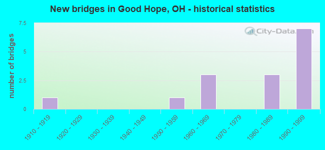
- New bridges - historical statistics
- 11910-1919
- 11950-1959
- 31960-1969
- 31980-1989
- 71990-1999

- Reconstructed bridges - Historical Statistics
- 11980-1989
- 21990-1999


- Bridge Condition - Deck
- 58.3%Very good
- 25.0%Good
- 8.3%Satisfactory
- 8.3%Fair

- Bridge Condition - Superstructure
- 16.7%Excellent
- 25.0%Very good
- 33.3%Good
- 25.0%Satisfactory

- Bridge Condition - Substructure
- 33.3%Very good
- 25.0%Good
- 25.0%Satisfactory
- 8.3%Fair
- 8.3%Poor

- Bridge Condition - Channel
- 30.8%Very good
- 46.2%Good
- 7.7%Satisfactory
- 15.4%Serious
Find on map >> Show street view
Structure Number: 2400715, Location: 1.4 MI W OF FAYETTE CTY L (Lat: 39.494561, Lng: -83.314611), Route carried "on" structure: County highway T0147, Year Built: 1998, Status: Open, Structure Length: 7.38m (24.21ft), Average Daily Traffic: 477 (year 2015), Truck Traffic: 8%, Average Future Daily Traffic: 662 (year 2038), Design Load: HS 20+Mod, Features Intersected: USR-35, Facility Carried by Structure: TWP 147 MILLS RD
Minimum Vertical Clearance: 30+ m (98+ ft), Kilometerpoint: 1.976, Lanes on structure: 2, Lanes under structure: 4, Owner: State Highway Agency, Approaching Roadway Width: 9.8m (32.2ft), Material/Design: Steel continuous, Design/Construction: Stringer/Multi-beam, Number Of Spans In Main Unit: 2, Length of Maximum Span: 36.6m (120.1ft), Curb-To-Curb Width: 9.8m (32.2ft), Out-to-Out Width: 10.7m (35.1ft)
Condition: Deck: Very good, Superstructure: Excellent, Substructure: Very good, Operating Rating: 32.4 metric tons, Method Used To Determine Operating Rating: Load Factor (LF) rating reported by rating factor (RF) method using MS18 loading, Inventory Rating: 25.9 metric tons, Method Used To Determine Inventory Rating: Load Factor (LF) rating reported by rating factor (RF) method using MS18 loading, Structural Evaluation: Equal to present minimum criteria, Deck Geometry: Equal to present minimum criteria, Underclear: Better than present minimum criteria, Approach Roadway Alignment: Equal to present minimum criteria, Designated Inspection Frequency: Every 24 months, Inspection Date: August 2021, Deck Structure Type: Concrete Cast-file-Place, Wearing Surface/Protective System: Wearing Surface: Monolithic Concrete, Deck Protection: Epoxy Coated Reinforcing
Find on map >> Show street view
Structure Number: 2400731, Location: RT SIDE OVER MILLS BRANCH (Lat: 39.493719, Lng: -83.311811), Route carried "on" structure: US 35, Year Built: 1998, Status: Open, Structure Length: 2.16m (7.09ft), Average Daily Traffic: 4,889 (year 2015), Truck Traffic: 37%, Average Future Daily Traffic: 6,786 (year 2038), Design Load: HS 20+Mod, Features Intersected: OVER MILLS BRANCH
Minimum Vertical Clearance: 30+ m (98+ ft), Kilometerpoint: 36.596, Lanes on structure: 2, Base Highway Network: Yes, Owner: State Highway Agency, Approaching Roadway Width: 17.1m (56.1ft), Skew: 2 degrees, Material/Design: Concrete continuous, Design/Construction: Slab, Number Of Spans In Main Unit: 3, Length of Maximum Span: 8.0m (26.2ft), Curb-To-Curb Width: 17.1m (56.1ft), Out-to-Out Width: 18.0m (59.1ft)
Condition: Deck: Very good, Superstructure: Excellent, Substructure: Very good, Channel: Serious, Operating Rating: 42.1 metric tons, Method Used To Determine Operating Rating: Load Factor (LF) rating reported by rating factor (RF) method using MS18 loading, Inventory Rating: 32.4 metric tons, Method Used To Determine Inventory Rating: Load Factor (LF) rating reported by rating factor (RF) method using MS18 loading, Structural Evaluation: Equal to present desirable criteria, Deck Geometry: Superior to present desirable criteria, Waterway Adequacy: Equal to present desirable criteria, Approach Roadway Alignment: Equal to present minimum criteria, Designated Inspection Frequency: Every 24 months, Inspection Date: August 2021, Deck Structure Type: Concrete Cast-file-Place, Wearing Surface/Protective System: Wearing Surface: Monolithic Concrete, Deck Protection: Epoxy Coated Reinforcing
Find on map >> Show street view
Structure Number: 2400766, Location: LT SIDE OVER MILLS BRANCH (Lat: 39.493569, Lng: -83.312050), Route carried "on" structure: US 35, Year Built: 1998, Status: Open, Structure Length: 2.16m (7.09ft), Average Daily Traffic: 4,889 (year 2015), Truck Traffic: 37%, Average Future Daily Traffic: 6,786 (year 2038), Design Load: HS 20+Mod, Features Intersected: OVER MILLS BRANCH
Minimum Vertical Clearance: 30+ m (98+ ft), Kilometerpoint: 36.596, Lanes on structure: 2, Base Highway Network: Yes, Owner: State Highway Agency, Approaching Roadway Width: 7.3m (24.0ft), Skew: 2 degrees, Material/Design: Concrete continuous, Design/Construction: Slab, Number Of Spans In Main Unit: 3, Length of Maximum Span: 8.0m (26.2ft), Curb-To-Curb Width: 17.1m (56.1ft), Out-to-Out Width: 18.0m (59.1ft)
Condition: Deck: Very good, Superstructure: Very good, Substructure: Satisfactory, Channel: Serious, Operating Rating: 42.1 metric tons, Method Used To Determine Operating Rating: Load Factor (LF) rating reported by rating factor (RF) method using MS18 loading, Inventory Rating: 32.4 metric tons, Method Used To Determine Inventory Rating: Load Factor (LF) rating reported by rating factor (RF) method using MS18 loading, Structural Evaluation: Equal to present minimum criteria, Deck Geometry: Superior to present desirable criteria, Waterway Adequacy: Equal to present desirable criteria, Approach Roadway Alignment: Equal to present minimum criteria, Designated Inspection Frequency: Every 12 months, Inspection Date: August 2021, Deck Structure Type: Concrete Cast-file-Place, Wearing Surface/Protective System: Wearing Surface: Monolithic Concrete, Deck Protection: Epoxy Coated Reinforcing
Find on map >> Show street view
Structure Number: 2403129, Location: 5.12 MIU S OF US35 (Lat: 39.448011, Lng: -83.366481), Route carried "on" structure: State highway 753, Year Built: 1962, Status: Open, Structure Length: 1.83m (6.00ft), Average Daily Traffic: 2,577 (year 2015), Truck Traffic: 8%, Average Future Daily Traffic: 3,577 (year 2038), Design Load: H 15, Features Intersected: INDIAN CREEK
Minimum Vertical Clearance: 30+ m (98+ ft), Kilometerpoint: 8.980, Lanes on structure: 2, Owner: State Highway Agency, Approaching Roadway Width: 11.0m (36.1ft), Skew: 1 degrees, Material/Design: Concrete continuous, Design/Construction: Slab, Number Of Spans In Main Unit: 3, Length of Maximum Span: 6.9m (22.6ft), Curb-To-Curb Width: 12.2m (40.0ft), Out-to-Out Width: 12.2m (40.0ft)
Condition: Deck: Fair, Superstructure: Satisfactory, Substructure: Fair, Channel: Satisfactory, Operating Rating: 42.1 metric tons, Method Used To Determine Operating Rating: Load Factor (LF) rating reported by rating factor (RF) method using MS18 loading, Inventory Rating: 25.9 metric tons, Method Used To Determine Inventory Rating: Load Factor (LF) rating reported by rating factor (RF) method using MS18 loading, Structural Evaluation: Somewhat better than minimum adequacy, Deck Geometry: Equal to present minimum criteria, Waterway Adequacy: Equal to present desirable criteria, Approach Roadway Alignment: Equal to present minimum criteria, Designated Inspection Frequency: Every 12 months, Inspection Date: April 2021, Deck Structure Type: Concrete Cast-file-Place, Wearing Surface/Protective System: Wearing Surface: Bituminous
Find on map >> Show street view
Structure Number: 2431998, Location: .1 MI S OLD US 35A (Lat: 39.450811, Lng: -83.361481), Route carried "on" structure: County highway C0142, Year Built: 1960, Year Reconstructed: 2004, Status: Open, Structure Length: 1.40m (4.59ft), Average Daily Traffic: 797 (year 2015), Truck Traffic: 8%, Average Future Daily Traffic: 1,106 (year 2035), Design Load: HS 20, Features Intersected: INDIAN CK - CAMP GROVE R, Facility Carried by Structure: CAMP GROV
Minimum Vertical Clearance: 30+ m (98+ ft), Kilometerpoint: 0.402, Lanes on structure: 2, Owner: County Highway Agency, Approaching Roadway Width: 9.4m (30.8ft), Material/Design: Prestressed concrete, Design/Construction: Box Beam or Girders - Multiple, Number Of Spans In Main Unit: 1, Length of Maximum Span: 13.4m (44.0ft), Curb-To-Curb Width: 6.7m (22.0ft), Out-to-Out Width: 7.3m (24.0ft)
Condition: Deck: Very good, Superstructure: Very good, Substructure: Satisfactory, Channel: Very good, Operating Rating: 42.1 metric tons, Method Used To Determine Operating Rating: Load Factor (LF) rating reported by rating factor (RF) method using MS18 loading, Inventory Rating: 32.4 metric tons, Method Used To Determine Inventory Rating: Load Factor (LF) rating reported by rating factor (RF) method using MS18 loading, Structural Evaluation: Equal to present minimum criteria, Deck Geometry: Meets minimum limits, Waterway Adequacy: Superior to present desirable criteria, Approach Roadway Alignment: Equal to present minimum criteria, Designated Inspection Frequency: Every 12 months, Inspection Date: April 2021, Deck Structure Type: Concrete Cast-file-Place, Wearing Surface/Protective System: Wearing Surface: Bituminous
Find on map >> Show street view
Structure Number: 2432218, Location: .7 MI. S. OF FLAKES FORD (Lat: 39.463789, Lng: -83.418061), Route carried "on" structure: County highway C0058, Year Built: 1996, Status: Open, Structure Length: 4.94m (16.21ft), Average Daily Traffic: 271 (year 2015), Truck Traffic: 7%, Average Future Daily Traffic: 376 (year 2035), Design Load: H 20, Features Intersected: MAIN PAINT-CREEK ROAD, Facility Carried by Structure: CREEK ROAD-CR 58
Minimum Vertical Clearance: 30+ m (98+ ft), Kilometerpoint: 3.058, Lanes on structure: 2, Owner: County Highway Agency, Approaching Roadway Width: 9.8m (32.2ft), Skew: 1 degrees, Material/Design: Prestressed concrete, Design/Construction: Box Beam or Girders - Multiple, Number Of Spans In Main Unit: 3, Length of Maximum Span: 16.5m (54.1ft), Curb-To-Curb Width: 7.3m (24.0ft), Out-to-Out Width: 7.3m (24.0ft)
Condition: Deck: Very good, Superstructure: Good, Substructure: Very good, Channel: Very good, Operating Rating: 42.1 metric tons, Method Used To Determine Operating Rating: Load Factor (LF) rating reported by rating factor (RF) method using MS18 loading, Inventory Rating: 32.4 metric tons, Method Used To Determine Inventory Rating: Load Factor (LF) rating reported by rating factor (RF) method using MS18 loading, Structural Evaluation: Better than present minimum criteria, Deck Geometry: Somewhat better than minimum adequacy, Waterway Adequacy: Superior to present desirable criteria, Approach Roadway Alignment: Equal to present minimum criteria, Designated Inspection Frequency: Every 24 months, Inspection Date: April 2021, Deck Structure Type: Concrete Cast-file-Place, Wearing Surface/Protective System: Wearing Surface: Bituminous, Membrane: Built-up
Find on map >> Show street view
Structure Number: 2432412, Location: 0.25 MI W SR 753 (Lat: 39.435439, Lng: -83.366931), Route carried "on" structure: County highway C0047, Year Built: 1966, Status: Open, Structure Length: 1.43m (4.69ft), Average Daily Traffic: 106 (year 2015), Truck Traffic: 8%, Average Future Daily Traffic: 147 (year 2035), Design Load: HS 20, Features Intersected: INDIAN CR MIAMI TRACE RD, Facility Carried by Structure: MIAMI TRACE ROAD
Minimum Vertical Clearance: 30+ m (98+ ft), Kilometerpoint: 28.164, Lanes on structure: 2, Owner: County Highway Agency, Approaching Roadway Width: 8.5m (27.9ft), Material/Design: Prestressed concrete, Design/Construction: Box Beam or Girders - Multiple, Number Of Spans In Main Unit: 1, Length of Maximum Span: 13.1m (43.0ft), Curb-To-Curb Width: 7.3m (24.0ft), Out-to-Out Width: 7.3m (24.0ft)
Condition: Deck: Good, Superstructure: Very good, Substructure: Satisfactory, Channel: Good, Operating Rating: 40.8 metric tons, Method Used To Determine Operating Rating: Field evaluation and documented engineering judgment, Inventory Rating: 32.7 metric tons, Method Used To Determine Inventory Rating: Field evaluation and documented engineering judgment, Structural Evaluation: Equal to present minimum criteria, Deck Geometry: Somewhat better than minimum adequacy, Waterway Adequacy: Better than present minimum criteria, Approach Roadway Alignment: Equal to present desirable criteria, Designated Inspection Frequency: Every 12 months, Inspection Date: April 2021, Deck Structure Type: Concrete Cast-file-Place, Wearing Surface/Protective System: Wearing Surface: Bituminous
Find on map >> Show street view
Structure Number: 2432692, Location: 0.6 MI W SR 753 (Lat: 39.470219, Lng: -83.396969), Route carried "on" structure: County highway C0055, Year Built: 1981, Status: Open, Structure Length: 5.03m (16.50ft), Average Daily Traffic: 216 (year 2015), Truck Traffic: 8%, Average Future Daily Traffic: 300 (year 2035), Design Load: H 20, Features Intersected: M PAINT CK - FLAKES FORD, Facility Carried by Structure: FLAKES FOR RD-CR55
Minimum Vertical Clearance: 30+ m (98+ ft), Kilometerpoint: 6.276, Lanes on structure: 2, Owner: County Highway Agency, Approaching Roadway Width: 10.4m (34.1ft), Skew: 3 degrees, Material/Design: Prestressed concrete, Design/Construction: Box Beam or Girders - Multiple, Number Of Spans In Main Unit: 3, Length of Maximum Span: 19.2m (63.0ft), Curb-To-Curb Width: 8.5m (27.9ft), Out-to-Out Width: 8.5m (27.9ft)
Condition: Deck: Good, Superstructure: Satisfactory, Substructure: Good, Channel: Very good, Operating Rating: 42.1 metric tons, Method Used To Determine Operating Rating: Load Factor (LF) rating reported by rating factor (RF) method using MS18 loading, Inventory Rating: 32.4 metric tons, Method Used To Determine Inventory Rating: Load Factor (LF) rating reported by rating factor (RF) method using MS18 loading, Structural Evaluation: Equal to present minimum criteria, Deck Geometry: Equal to present minimum criteria, Waterway Adequacy: Better than present minimum criteria, Approach Roadway Alignment: Superior to present desirable criteria, Designated Inspection Frequency: Every 12 months, Inspection Date: April 2021, Deck Structure Type: Concrete Cast-file-Place
Find on map >> Show street view
Structure Number: 2432846, Location: 0.5 MI S OLD USR 35 (Lat: 39.488789, Lng: -83.319061), Route carried "on" structure: County highway C0147, Year Built: 1983, Status: Open, Structure Length: 1.01m (3.31ft), Average Daily Traffic: 477 (year 2015), Truck Traffic: 8%, Average Future Daily Traffic: 662 (year 2035), Design Load: H 20, Features Intersected: MILLS BRANCH MILLS ROAD, Facility Carried by Structure: MILLS ROAD- CR 147
Minimum Vertical Clearance: 30+ m (98+ ft), Kilometerpoint: 1.207, Lanes on structure: 2, Owner: County Highway Agency, Approaching Roadway Width: 7.3m (24.0ft), Material/Design: Steel, Design/Construction: Culvert, Number Of Spans In Main Unit: 1, Length of Maximum Span: 10.1m (33.1ft)
Condition: Channel: Good, Culverts: Good, Operating Rating: 42.1 metric tons, Method Used To Determine Operating Rating: Load Factor (LF) rating reported by rating factor (RF) method using MS18 loading, Inventory Rating: 32.4 metric tons, Method Used To Determine Inventory Rating: Load Factor (LF) rating reported by rating factor (RF) method using MS18 loading, Structural Evaluation: Better than present minimum criteria, Waterway Adequacy: Superior to present desirable criteria, Approach Roadway Alignment: Equal to present minimum criteria, Designated Inspection Frequency: Every 24 months, Inspection Date: March 2020
Find on map >> Show street view
Structure Number: 243287, Location: AT INT. WITH CREEK ROAD (Lat: 39.442719, Lng: -83.410311), Route carried "on" structure: County highway C0047, Year Built: 1984, Status: Open, Structure Length: 6.77m (22.21ft), Average Daily Traffic: 183 (year 2015), Truck Traffic: 8%, Average Future Daily Traffic: 254 (year 2035), Design Load: HS 20, Features Intersected: MAIN PAINT CR MIAMI TRAC, Facility Carried by Structure: MIAMI TRACE ROAD
Minimum Vertical Clearance: 30+ m (98+ ft), Kilometerpoint: 24.060, Lanes on structure: 2, Owner: County Highway Agency, Approaching Roadway Width: 11.0m (36.1ft), Material/Design: Steel continuous, Design/Construction: Stringer/Multi-beam, Number Of Spans In Main Unit: 3, Length of Maximum Span: 25.6m (84.0ft), Curb-To-Curb Width: 7.9m (25.9ft), Out-to-Out Width: 7.9m (25.9ft)
Condition: Deck: Very good, Superstructure: Good, Substructure: Good, Channel: Good, Operating Rating: 35.6 metric tons, Method Used To Determine Operating Rating: Load Factor (LF) rating reported by rating factor (RF) method using MS18 loading, Inventory Rating: 22.7 metric tons, Method Used To Determine Inventory Rating: Load Factor (LF) rating reported by rating factor (RF) method using MS18 loading, Structural Evaluation: Equal to present minimum criteria, Deck Geometry: Somewhat better than minimum adequacy, Waterway Adequacy: Superior to present desirable criteria, Approach Roadway Alignment: Equal to present minimum criteria, Designated Inspection Frequency: Every 24 months, Inspection Date: April 2021, Deck Structure Type: Concrete Cast-file-Place, Wearing Surface/Protective System: Wearing Surface: Integral Concrete
Find on map >> Show street view
Structure Number: 2433079, Location: 0.6 MI E OF SR 41 (Lat: 39.409289, Lng: -83.383619), Route carried "on" structure: County highway T0156, Year Built: 1992, Status: Open, Structure Length: 6.07m (19.91ft), Average Daily Traffic: 109 (year 2015), Truck Traffic: 7%, Average Future Daily Traffic: 151 (year 2035), Design Load: H 20, Features Intersected: MAIN PAINT CK GHORMLEY R, Facility Carried by Structure: GHORMLEY ROAD
Minimum Vertical Clearance: 30+ m (98+ ft), Kilometerpoint: 6.518, Lanes on structure: 2, Owner: County Highway Agency, Approaching Roadway Width: 7.0m (23.0ft), Skew: 1 degrees, Material/Design: Prestressed concrete, Design/Construction: Box Beam or Girders - Multiple, Number Of Spans In Main Unit: 3, Length of Maximum Span: 20.1m (65.9ft), Curb-To-Curb Width: 7.3m (24.0ft), Out-to-Out Width: 7.3m (24.0ft)
Condition: Deck: Very good, Superstructure: Good, Substructure: Very good, Channel: Very good, Operating Rating: 42.1 metric tons, Method Used To Determine Operating Rating: Load Factor (LF) rating reported by rating factor (RF) method using MS18 loading, Inventory Rating: 32.4 metric tons, Method Used To Determine Inventory Rating: Load Factor (LF) rating reported by rating factor (RF) method using MS18 loading, Structural Evaluation: Better than present minimum criteria, Deck Geometry: Somewhat better than minimum adequacy, Waterway Adequacy: Superior to present desirable criteria, Approach Roadway Alignment: Equal to present minimum criteria, Designated Inspection Frequency: Every 24 months, Inspection Date: April 2021, Deck Structure Type: Concrete Cast-file-Place, Wearing Surface/Protective System: Wearing Surface: Bituminous, Membrane: Built-up
Find on map >> Show street view
Structure Number: 7104006, Location: 5.03 MI N OF HIGHLAND CO (Lat: 39.400039, Lng: -83.313650), Route carried "on" structure: State highway 138, Year Built: 1997, Status: Open, Structure Length: 0.67m (2.20ft), Average Daily Traffic: 1,713 (year 2015), Truck Traffic: 8%, Average Future Daily Traffic: 2,378 (year 2035), Design Load: HS 20+Mod, Features Intersected: LOWER BUCKSKIN CREEK
Minimum Vertical Clearance: 30+ m (98+ ft), Kilometerpoint: 7.998, Lanes on structure: 2, Owner: State Highway Agency, Approaching Roadway Width: 9.8m (32.2ft), Material/Design: Concrete, Design/Construction: Culvert, Number Of Spans In Main Unit: 1, Length of Maximum Span: 6.1m (20.0ft)
Condition: Channel: Good, Culverts: Good, Operating Rating: 42.1 metric tons, Method Used To Determine Operating Rating: Load Factor (LF) rating reported by rating factor (RF) method using MS18 loading, Inventory Rating: 32.4 metric tons, Method Used To Determine Inventory Rating: Load Factor (LF) rating reported by rating factor (RF) method using MS18 loading, Structural Evaluation: Better than present minimum criteria, Waterway Adequacy: Equal to present desirable criteria, Approach Roadway Alignment: Better than present minimum criteria, Designated Inspection Frequency: Every 24 months, Inspection Date: September 2020
Find on map >> Show street view
Structure Number: 7134355, Location: .80MI NW OF GOODHOPE RD (Lat: 39.452431, Lng: -83.305450), Route carried "on" structure: County highway T0076, Year Built: 1950, Year Reconstructed: 1994, Status: Posted for load, Structure Length: 1.25m (4.10ft), Average Daily Traffic: 324 (year 2015), Truck Traffic: 7%, Average Future Daily Traffic: 450 (year 2035), Features Intersected: HERROD CREEK, Facility Carried by Structure: DOUGLAS RD
Minimum Vertical Clearance: 30+ m (98+ ft), Kilometerpoint: 3.975, Lanes on structure: 2, Owner: County Highway Agency, Approaching Roadway Width: 6.7m (22.0ft), Skew: 2 degrees, Material/Design: Steel, Design/Construction: Stringer/Multi-beam, Number Of Spans In Main Unit: 1, Length of Maximum Span: 11.9m (39.0ft), Curb-To-Curb Width: 6.7m (22.0ft), Out-to-Out Width: 6.8m (22.3ft)
Condition: Deck: Satisfactory, Superstructure: Satisfactory, Substructure: Good, Channel: Good, Operating Rating: 25.9 metric tons, Method Used To Determine Operating Rating: Load Factor (LF) rating reported by rating factor (RF) method using MS18 loading, Inventory Rating: 16.2 metric tons, Method Used To Determine Inventory Rating: Load Factor (LF) rating reported by rating factor (RF) method using MS18 loading, Structural Evaluation: Somewhat better than minimum adequacy, Deck Geometry: Meets minimum limits, Waterway Adequacy: Better than present minimum criteria, Approach Roadway Alignment: Equal to present desirable criteria, Bridge Posting: Required (Relationship of Operating Rating to Maximum Legal Load: 30.0 - 39.9% below), Designated Inspection Frequency: Every 12 months, Inspection Date: September 2021, Deck Structure Type: Wood or Timber, Wearing Surface/Protective System: Wearing Surface: Bituminous
Find on map >> Show street view
Structure Number: 7134533, Location: .05MI E OF FAYETTE CO LIN (Lat: 39.441781, Lng: -83.322300), Route carried "on" structure: County highway C0082, Year Built: 1911, Year Reconstructed: 1990, Status: Open, Structure Length: 1.07m (3.51ft), Average Daily Traffic: 66 (year 2015), Truck Traffic: 8%, Average Future Daily Traffic: 92 (year 2035), Design Load: HS 20, Features Intersected: HERRODS CREEK, Facility Carried by Structure: GOODHOPE RD
Minimum Vertical Clearance: 30+ m (98+ ft), Kilometerpoint: 0.080, Lanes on structure: 1, Owner: County Highway Agency, Approaching Roadway Width: 7.3m (24.0ft), Material/Design: Prestressed concrete, Design/Construction: Box Beam or Girders - Multiple, Number Of Spans In Main Unit: 1, Length of Maximum Span: 10.1m (33.1ft), Curb-To-Curb Width: 7.3m (24.0ft), Out-to-Out Width: 7.3m (24.0ft)
Condition: Deck: Good, Superstructure: Good, Substructure: Poor, Channel: Good, Operating Rating: 77.8 metric tons, Method Used To Determine Operating Rating: Load Factor (LF) rating reported by rating factor (RF) method using MS18 loading, Inventory Rating: 45.4 metric tons, Method Used To Determine Inventory Rating: Load Factor (LF) rating reported by rating factor (RF) method using MS18 loading, Structural Evaluation: Meets minimum limits, Deck Geometry: Equal to present minimum criteria, Waterway Adequacy: Better than present minimum criteria, Approach Roadway Alignment: Equal to present desirable criteria, Designated Inspection Frequency: Every 12 months, Inspection Date: October 2021, Deck Structure Type: Concrete Cast-file-Place, Wearing Surface/Protective System: Wearing Surface: Bituminous
Find on map >> Show street view
Structure Number: 2400715, Location: 1.4 MI W OF FAYETTE CTY L (Lat: 39.494561, Lng: -83.314611), Route carried "under" structure: US 35, Year Built: 1998, Structure Length: 0. m, Average Daily Traffic: 12,198 (year 2017), Truck Traffic: 31%, Features Intersected: TR-147 MILLS RD, Facility Carried by Structure: TWP 147 MILLS RD
Minimum Vertical Clearance: 5.13m (16.83ft), Kilometerpoint: 36.371, Lanes on structure: 2, Lanes under structure: 4, Material/Design: Steel continuous, Design/Construction: Stringer/Multi-beam, Length of Maximum Span: 36.6m (120.1ft)