Bridge Statistics for Gold Beach, Oregon (OR)
Condition, Traffic, Stress, Structural Evaluation, Project Costs
- National Bridge Inventory (NBI) Statistics
- 13Number of bridges
- 338ft / 103mTotal length
- $11,886,000Total costs
- 23,143Total average daily traffic
- 3,551Total average daily truck traffic
- National Bridge Inventory (NBI) Registered Bridges for Gold Beach
- No street view available for this location
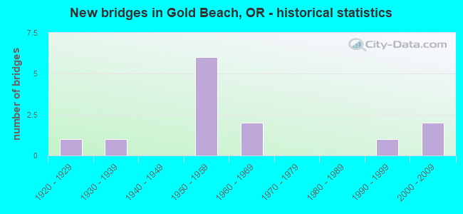
- New bridges - historical statistics
- 11920-1929
- 11930-1939
- 61950-1959
- 21960-1969
- 11990-1999
- 22000-2009
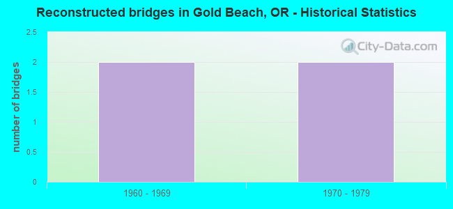
- Reconstructed bridges - Historical Statistics
- 21960-1969
- 21970-1979
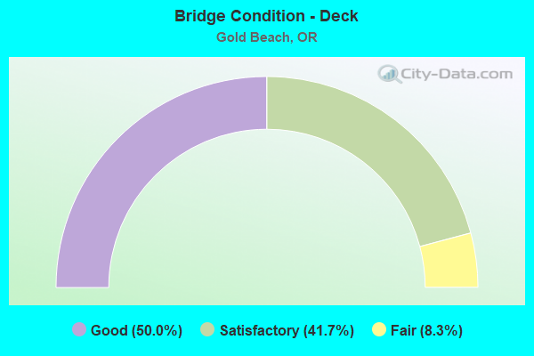
- Bridge Condition - Deck
- 50.0%Good
- 41.7%Satisfactory
- 8.3%Fair
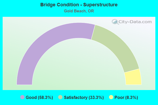
- Bridge Condition - Superstructure
- 58.3%Good
- 33.3%Satisfactory
- 8.3%Poor
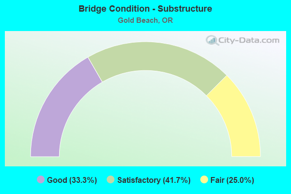
- Bridge Condition - Substructure
- 33.3%Good
- 41.7%Satisfactory
- 25.0%Fair
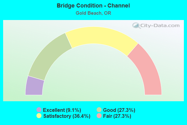
- Bridge Condition - Channel
- 9.1%Excellent
- 27.3%Good
- 36.4%Satisfactory
- 27.3%Fair
Find on map >> Show street view
Structure Number: 1172 009 32764, Location: OXING ROGUE RIVER (Lat: 42.427400, Lng: -124.413250), Route carried "on" structure: US 101, Year Built: 1930, Status: Open, Structure Length: 57.85m (189.80ft), Average Daily Traffic: 6,410 (year 2020), Truck Traffic: 18%, Average Future Daily Traffic: 7,300 (year 2040), Design Load: H 15, Features Intersected: ROGUE RIVER (WEDDERBURN)
Minimum Vertical Clearance: 30+ m (98+ ft), Kilometerpoint: 527.382, Lanes on structure: 2, Base Highway Network: Yes, Owner: State Highway Agency, Approaching Roadway Width: 8.2m (26.9ft), Material/Design: Concrete continuous, Design/Construction: Arch - Deck, Number Of Spans In Main Unit: 7, Number Of Approach Spans: 18, Length of Maximum Span: 70.1m (230.0ft), Curb or Sidewalk Widths: Left: 1.1m (3.6ft), Right: 1.1m (3.6ft), Curb-To-Curb Width: 8.2m (26.9ft), Out-to-Out Width: 11.1m (36.4ft)
Condition: Deck: Satisfactory, Superstructure: Satisfactory, Substructure: Satisfactory, Channel: Satisfactory, Operating Rating: 25.3 metric tons, Method Used To Determine Operating Rating: Load and Resistance Factor Rating (LRFR) rating reported by rating factor(RF) method using HL-93 loadings, Inventory Rating: 19.4 metric tons, Method Used To Determine Inventory Rating: Load and Resistance Factor Rating (LRFR) rating reported by rating factor(RF) method using HL-93 loadings, Structural Evaluation: Meets minimum limits, Deck Geometry: High priority of corrective action, Waterway Adequacy: Superior to present desirable criteria, Approach Roadway Alignment: Equal to present minimum criteria, Length Of Structure Improvement: 63.60m (208.66ft), Designated Inspection Frequency: Every 24 months, Underwater Inspection Frequency: Every 24 months, Inspection Date: August 2021, Underwater Inspection Date: August 2021, Bridge Improvement Cost: $6,686,000, Roadway Improvement Cost: $669,000, Total Project Cost: $10,697,000, Deck Structure Type: Concrete Cast-file-Place, Wearing Surface/Protective System: Wearing Surface: Latex Concrete, Deck Protection: Cathodic Protection
Find on map >> Show street view
Structure Number: 61103000001096, Location: 5 MI EASTLY OF HWY 101 (Lat: 42.352247, Lng: -124.353617), Route carried "on" structure: Federal lands road 36800, Year Built: 1965, Status: Open, Structure Length: 4.93m (16.17ft), Average Daily Traffic: 38 (year 1995), Average Future Daily Traffic: 57 (year 2042), Features Intersected: HUNTER CREEK, Facility Carried by Structure: HUNTER CREEK ROAD
Minimum Vertical Clearance: 30+ m (98+ ft), Kilometerpoint: 0.320, Lanes on structure: 1, Owner: U.S. Forest Service, Approaching Roadway Width: 6.7m (22.0ft), Material/Design: Steel, Design/Construction: Stringer/Multi-beam, Number Of Spans In Main Unit: 3, Length of Maximum Span: 26.2m (86.0ft), Curb or Sidewalk Widths: Left: 1.1m (3.6ft), Right: 0.3m (1.0ft), Curb-To-Curb Width: 4.3m (14.1ft), Out-to-Out Width: 5.6m (18.4ft)
Condition: Deck: Satisfactory, Superstructure: Good, Substructure: Good, Channel: Excellent, Operating Rating: 54.5 metric tons, Method Used To Determine Operating Rating: Allowable Stress (AS), Inventory Rating: 36.3 metric tons, Method Used To Determine Inventory Rating: Allowable Stress (AS), Structural Evaluation: Better than present minimum criteria, Deck Geometry: Equal to present minimum criteria, Waterway Adequacy: Equal to present desirable criteria, Approach Roadway Alignment: Equal to present minimum criteria, Designated Inspection Frequency: Every 24 months, Critical Feature Inspection Frequency: Every 24 months, Other Special Inspection Frequency: Every 72 months, Inspection Date: July 2020, Critical Feature Inspection Date: July 2020, Other Special Inspection Date: August 2018, Deck Structure Type: Concrete Cast-file-Place
Find on map >> Show street view
Structure Number: 61103000001097, Location: 6 MI EASTLY OF HWY 101 (Lat: 42.349728, Lng: -124.346389), Route carried "on" structure: Federal lands road 36800, Year Built: 1964, Status: Open, Structure Length: 5.27m (17.29ft), Average Daily Traffic: 38 (year 1995), Average Future Daily Traffic: 57 (year 2042), Features Intersected: HUNTER CREEK, Facility Carried by Structure: HUNTER CREEK ROAD
Minimum Vertical Clearance: 30+ m (98+ ft), Kilometerpoint: 1.280, Lanes on structure: 1, Owner: U.S. Forest Service, Approaching Roadway Width: 6.7m (22.0ft), Skew: 3 degrees, Material/Design: Concrete continuous, Design/Construction: Frame, Number Of Spans In Main Unit: 4, Length of Maximum Span: 21.3m (69.9ft), Curb or Sidewalk Widths: Left: 1.1m (3.6ft), Right: 0.3m (1.0ft), Curb-To-Curb Width: 4.3m (14.1ft), Out-to-Out Width: 5.6m (18.4ft)
Condition: Deck: Fair, Superstructure: Satisfactory, Substructure: Satisfactory, Channel: Satisfactory, Operating Rating: 40.9 metric tons, Method Used To Determine Operating Rating: Load Factor (LF), Inventory Rating: 28.1 metric tons, Method Used To Determine Inventory Rating: Load Factor (LF), Structural Evaluation: Equal to present minimum criteria, Deck Geometry: Equal to present minimum criteria, Waterway Adequacy: Superior to present desirable criteria, Approach Roadway Alignment: Equal to present minimum criteria, Designated Inspection Frequency: Every 24 months, Inspection Date: June 2020, Deck Structure Type: Concrete Cast-file-Place
Find on map >> Show street view
Structure Number: 8290 009 33048, Location: 02.8 MI S ROGUE RIVER (Lat: 42.388731, Lng: -124.422661), Route carried "on" structure: US 101, Year Built: 1959, Status: Open, Structure Length: 10.97m (35.99ft), Average Daily Traffic: 4,269 (year 2020), Truck Traffic: 20%, Average Future Daily Traffic: 4,900 (year 2040), Design Load: HS 20, Features Intersected: HUNTER CREEK
Minimum Vertical Clearance: 30+ m (98+ ft), Kilometerpoint: 531.856, Lanes on structure: 2, Base Highway Network: Yes, Owner: State Highway Agency, Approaching Roadway Width: 9.1m (29.9ft), Skew: 3 degrees, Material/Design: Concrete continuous, Design/Construction: Box Beam or Girders - Multiple, Number Of Spans In Main Unit: 4, Length of Maximum Span: 30.5m (100.1ft), Curb-To-Curb Width: 9.1m (29.9ft), Out-to-Out Width: 10.5m (34.4ft)
Condition: Deck: Satisfactory, Superstructure: Satisfactory, Substructure: Satisfactory, Channel: Good, Operating Rating: 23.0 metric tons, Method Used To Determine Operating Rating: Load and Resistance Factor Rating (LRFR) rating reported by rating factor(RF) method using HL-93 loadings, Inventory Rating: 17.8 metric tons, Method Used To Determine Inventory Rating: Load and Resistance Factor Rating (LRFR) rating reported by rating factor(RF) method using HL-93 loadings, Structural Evaluation: Meets minimum limits, Deck Geometry: Meets minimum limits, Waterway Adequacy: Equal to present desirable criteria, Approach Roadway Alignment: Equal to present desirable criteria, Designated Inspection Frequency: Every 24 months, Underwater Inspection Frequency: Every 36 months, Inspection Date: May 2021, Underwater Inspection Date: September 2020, Deck Structure Type: Concrete Cast-file-Place, Wearing Surface/Protective System: Wearing Surface: Latex Concrete
Find on map >> Show street view
Structure Number: 15C00905950007, Location: 0.7 MI E PATTERSON BRIDGE (Lat: 42.428200, Lng: -124.403508), Route carried "on" structure: ServiceCounty highway A305, Year Built: 1957, Year Reconstructed: 1973, Status: Open, Structure Length: 1.07m (3.51ft), Average Daily Traffic: 3,451 (year 2020), Truck Traffic: 10%, Average Future Daily Traffic: 3,901 (year 2025), Design Load: H 20, Features Intersected: INDIAN CREEK, Facility Carried by Structure: JERRYS FLAT ROAD
Minimum Vertical Clearance: 30+ m (98+ ft), Kilometerpoint: 1.127, Lanes on structure: 2, Owner: County Highway Agency, Approaching Roadway Width: 7.9m (25.9ft), Material/Design: Prestressed concrete, Design/Construction: Slab, Number Of Spans In Main Unit: 1, Length of Maximum Span: 9.1m (29.9ft), Curb or Sidewalk Widths: Left: 0.9m (3.0ft), Right: 0.0m, Curb-To-Curb Width: 9.1m (29.9ft), Out-to-Out Width: 13.4m (44.0ft)
Condition: Deck: Satisfactory, Superstructure: Satisfactory, Substructure: Satisfactory, Channel: Satisfactory, Operating Rating: 79.8 metric tons, Method Used To Determine Operating Rating: Load Factor (LF), Inventory Rating: 48.1 metric tons, Method Used To Determine Inventory Rating: Load Factor (LF), Structural Evaluation: Equal to present minimum criteria, Deck Geometry: Meets minimum limits, Waterway Adequacy: Equal to present desirable criteria, Approach Roadway Alignment: Equal to present desirable criteria, Designated Inspection Frequency: Every 24 months, Inspection Date: July 2020, Deck Structure Type: Other, Wearing Surface/Protective System: Wearing Surface: Bituminous
Find on map >> Show street view
Structure Number: 15C01006350004, Location: .2 MI N GOLD BEACH LUMBER (Lat: 42.389964, Lng: -124.415528), Route carried "on" structure: ServiceCounty highway A304, Year Built: 1928, Year Reconstructed: 1975, Status: Posted for load, Structure Length: 6.31m (20.70ft), Average Daily Traffic: 739 (year 2020), Truck Traffic: 10%, Average Future Daily Traffic: 834 (year 2025), Design Load: H 15, Features Intersected: HUNTER CREEK, Facility Carried by Structure: HUNTER CREEK RD
Minimum Vertical Clearance: 30+ m (98+ ft), Kilometerpoint: 0.322, Lanes on structure: 2, Owner: County Highway Agency, Approaching Roadway Width: 9.8m (32.2ft), Skew: 3 degrees, Material/Design: Concrete, Design/Construction: Tee Beam, Number Of Spans In Main Unit: 5, Length of Maximum Span: 18.3m (60.0ft), Curb-To-Curb Width: 6.6m (21.7ft), Out-to-Out Width: 7.6m (24.9ft)
Condition: Deck: Satisfactory, Superstructure: Poor, Substructure: Fair, Channel: Fair, Operating Rating: 15.9 metric tons, Method Used To Determine Operating Rating: Load and Resistance Factor Rating (LRFR) rating reported by rating factor(RF) method using HL-93 loadings, Inventory Rating: 12.3 metric tons, Method Used To Determine Inventory Rating: Load and Resistance Factor Rating (LRFR) rating reported by rating factor(RF) method using HL-93 loadings, Structural Evaluation: High priority of corrective action, Deck Geometry: High priority of corrective action, Waterway Adequacy: Equal to present desirable criteria, Approach Roadway Alignment: Equal to present minimum criteria, Bridge Posting: Required (Relationship of Operating Rating to Maximum Legal Load: 20.0 - 29.9% below), Length Of Structure Improvement: 6.30m (20.67ft), Designated Inspection Frequency: Every 24 months, Underwater Inspection Frequency: Every 24 months, Inspection Date: November 2020, Underwater Inspection Date: August 2021, Bridge Improvement Cost: $663,000, Roadway Improvement Cost: $66,000, Total Project Cost: $1,061,000, Deck Structure Type: Concrete Cast-file-Place, Wearing Surface/Protective System: Wearing Surface: Bituminous
Find on map >> Show street view
Structure Number: 15C24 635 0009, Location: 1.9 MI E GOLD BEACH LUM (Lat: 42.371806, Lng: -124.408381), Route carried "on" structure: ServiceCounty highway A304, Year Built: 1959, Year Reconstructed: 1968, Status: Open, Structure Length: 5.30m (17.39ft), Average Daily Traffic: 1,680 (year 2020), Truck Traffic: 10%, Average Future Daily Traffic: 1,900 (year 2025), Design Load: HS 20, Features Intersected: HUNTER'S CREEK, Facility Carried by Structure: HUNTER CREEK RD
Minimum Vertical Clearance: 30+ m (98+ ft), Kilometerpoint: 1.448, Lanes on structure: 2, Owner: County Highway Agency, Approaching Roadway Width: 9.8m (32.2ft), Skew: 3 degrees, Material/Design: Concrete continuous, Design/Construction: Tee Beam, Number Of Spans In Main Unit: 4, Length of Maximum Span: 19.8m (65.0ft), Curb-To-Curb Width: 7.7m (25.3ft), Out-to-Out Width: 8.8m (28.9ft)
Condition: Deck: Good, Superstructure: Good, Substructure: Fair, Channel: Satisfactory, Operating Rating: 35.4 metric tons, Method Used To Determine Operating Rating: Load Factor (LF), Inventory Rating: 20.9 metric tons, Method Used To Determine Inventory Rating: Load Factor (LF), Structural Evaluation: Somewhat better than minimum adequacy, Deck Geometry: Meets minimum limits, Waterway Adequacy: Equal to present desirable criteria, Approach Roadway Alignment: Equal to present minimum criteria, Designated Inspection Frequency: Every 24 months, Underwater Inspection Frequency: Every 60 months, Inspection Date: November 2020, Underwater Inspection Date: June 2018, Deck Structure Type: Concrete Cast-file-Place, Wearing Surface/Protective System: Wearing Surface: Bituminous
Find on map >> Show street view
Structure Number: 15C25 635 0038, Location: 3.8 MI E HWY 101 (Lat: 42.354889, Lng: -124.373317), Route carried "on" structure: ServiceCounty highway A304, Year Built: 1959, Year Reconstructed: 1976, Status: Open, Structure Length: 5.24m (17.19ft), Average Daily Traffic: 208 (year 2020), Truck Traffic: 4%, Average Future Daily Traffic: 233 (year 2025), Design Load: HS 20, Features Intersected: HUNTER'S CREEK, Facility Carried by Structure: HUNTER CREEK RD
Minimum Vertical Clearance: 30+ m (98+ ft), Kilometerpoint: 6.116, Lanes on structure: 2, Owner: County Highway Agency, Approaching Roadway Width: 9.1m (29.9ft), Skew: 1 degrees, Material/Design: Concrete continuous, Design/Construction: Tee Beam, Number Of Spans In Main Unit: 4, Length of Maximum Span: 19.8m (65.0ft), Curb-To-Curb Width: 9.4m (30.8ft), Out-to-Out Width: 10.1m (33.1ft)
Condition: Deck: Good, Superstructure: Good, Substructure: Fair, Channel: Fair, Operating Rating: 42.6 metric tons, Method Used To Determine Operating Rating: Load Factor (LF), Inventory Rating: 25.4 metric tons, Method Used To Determine Inventory Rating: Load Factor (LF), Structural Evaluation: Somewhat better than minimum adequacy, Deck Geometry: Equal to present minimum criteria, Waterway Adequacy: Equal to present desirable criteria, Approach Roadway Alignment: Equal to present minimum criteria, Designated Inspection Frequency: Every 24 months, Underwater Inspection Frequency: Every 60 months, Inspection Date: November 2020, Underwater Inspection Date: June 2018, Deck Structure Type: Concrete Cast-file-Place, Wearing Surface/Protective System: Wearing Surface: Bituminous
Find on map >> Show street view
Structure Number: 16014 009 32647, Location: 01.1 MI N ROGUE RIVER (Lat: 42.431869, Lng: -124.430850), Route carried "on" structure: US 101, Year Built: 1956, Status: Posted for load, Structure Length: 0.76m (2.49ft), Average Daily Traffic: 3,429 (year 2020), Truck Traffic: 18%, Average Future Daily Traffic: 4,100 (year 2040), Design Load: H 20, Features Intersected: CONN RD
Minimum Vertical Clearance: 30+ m (98+ ft), Kilometerpoint: 525.403, Lanes on structure: 2, Lanes under structure: 2, Base Highway Network: Yes, Owner: State Highway Agency, Approaching Roadway Width: 11.7m (38.4ft), Material/Design: Concrete, Design/Construction: Frame, Number Of Spans In Main Unit: 1, Length of Maximum Span: 7.6m (24.9ft), Curb-To-Curb Width: 14.0m (45.9ft), Out-to-Out Width: 14.0m (45.9ft)
Condition: Deck: Good, Superstructure: Good, Substructure: Satisfactory, Operating Rating: 28.4 metric tons, Method Used To Determine Operating Rating: Field evaluation and documented engineering judgment, Inventory Rating: 21.9 metric tons, Method Used To Determine Inventory Rating: Field evaluation and documented engineering judgment, Structural Evaluation: Somewhat better than minimum adequacy, Deck Geometry: Superior to present desirable criteria, Underclear: High priority of corrective action, Approach Roadway Alignment: Equal to present desirable criteria, Bridge Posting: Required (Relationship of Operating Rating to Maximum Legal Load: 10.0 - 19.9% below), Length Of Structure Improvement: 0.80m (2.62ft), Designated Inspection Frequency: Every 24 months, Inspection Date: May 2021, Bridge Improvement Cost: $80,000, Roadway Improvement Cost: $8,000, Total Project Cost: $128,000, Deck Structure Type: Concrete Cast-file-Place
Find on map >> Show street view
Structure Number: 18059 00015C02, Location: 2.8 MI E OF GOLD BEACH (Lat: 42.445358, Lng: -124.370211), Route carried "on" structure: ServiceCounty highway A305, Year Built: 1993, Status: Open, Structure Length: 1.80m (5.91ft), Average Daily Traffic: 2,219 (year 2020), Truck Traffic: 10%, Average Future Daily Traffic: 2,509 (year 2025), Design Load: HS 25 or greater, Features Intersected: SAUNDERS CREEK, Facility Carried by Structure: COUNTY RD 595
Minimum Vertical Clearance: 30+ m (98+ ft), Kilometerpoint: 4.989, Lanes on structure: 2, Owner: County Highway Agency, Approaching Roadway Width: 11.0m (36.1ft), Material/Design: Prestressed concrete, Design/Construction: Slab, Number Of Spans In Main Unit: 1, Length of Maximum Span: 17.7m (58.1ft), Curb-To-Curb Width: 10.8m (35.4ft), Out-to-Out Width: 11.0m (36.1ft)
Condition: Deck: Good, Superstructure: Good, Substructure: Good, Channel: Fair, Operating Rating: 72.6 metric tons, Method Used To Determine Operating Rating: Load Factor (LF), Inventory Rating: 43.5 metric tons, Method Used To Determine Inventory Rating: Load Factor (LF), Structural Evaluation: Better than present minimum criteria, Deck Geometry: Somewhat better than minimum adequacy, Waterway Adequacy: Equal to present desirable criteria, Approach Roadway Alignment: Equal to present desirable criteria, Designated Inspection Frequency: Every 24 months, Inspection Date: November 2020, Deck Structure Type: Other, Wearing Surface/Protective System: Wearing Surface: Bituminous, Membrane: Epoxy
Find on map >> Show street view
Structure Number: 20182 000 0011, Location: Milepoint 1.1 (Lat: 42.340850, Lng: -124.351019), Route carried "on" structure: County highway , Year Built: 2004, Status: Open, Structure Length: 1.78m (5.84ft), Average Daily Traffic: 74 (year 2020), Truck Traffic: 5%, Average Future Daily Traffic: 84 (year 2025), Design Load: HL 93, Features Intersected: Metzgus Creek, Facility Carried by Structure: LS Fk Hunter Ck Rd
Minimum Vertical Clearance: 30+ m (98+ ft), Kilometerpoint: 1.770, Lanes on structure: 2, Owner: County Highway Agency, Approaching Roadway Width: 6.5m (21.3ft), Material/Design: Prestressed concrete, Design/Construction: Slab, Number Of Spans In Main Unit: 1, Length of Maximum Span: 17.1m (56.1ft), Curb-To-Curb Width: 6.5m (21.3ft), Out-to-Out Width: 7.3m (24.0ft)
Condition: Deck: Good, Superstructure: Good, Substructure: Good, Channel: Good, Operating Rating: 58.0 metric tons, Method Used To Determine Operating Rating: Load and Resistance Factor Rating (LRFR) rating reported by rating factor(RF) method using HL-93 loadings, Inventory Rating: 44.7 metric tons, Method Used To Determine Inventory Rating: Load and Resistance Factor Rating (LRFR) rating reported by rating factor(RF) method using HL-93 loadings, Structural Evaluation: Better than present minimum criteria, Deck Geometry: Somewhat better than minimum adequacy, Waterway Adequacy: Equal to present desirable criteria, Approach Roadway Alignment: Equal to present minimum criteria, Designated Inspection Frequency: Every 24 months, Inspection Date: November 2020, Deck Structure Type: Other, Wearing Surface/Protective System: Wearing Surface: Bituminous, Deck Protection: Epoxy Coated Reinforcing
Find on map >> Show street view
Structure Number: 21001, Location: Milepoint 1.50 (Lat: 42.337144, Lng: -124.351611), Route carried "on" structure: County highway , Year Built: 2009, Status: Open, Structure Length: 1.80m (5.91ft), Average Daily Traffic: 74 (year 2020), Truck Traffic: 5%, Average Future Daily Traffic: 84 (year 2025), Design Load: HL 93, Features Intersected: S. Fork Hunter Cr, Facility Carried by Structure: S Fk Hunter Ck Rd
Minimum Vertical Clearance: 30+ m (98+ ft), Kilometerpoint: 2.414, Lanes on structure: 2, Owner: County Highway Agency, Approaching Roadway Width: 11.8m (38.7ft), Material/Design: Prestressed concrete, Design/Construction: Slab, Number Of Spans In Main Unit: 1, Length of Maximum Span: 18.0m (59.1ft), Curb-To-Curb Width: 11.8m (38.7ft), Out-to-Out Width: 13.4m (44.0ft)
Condition: Deck: Good, Superstructure: Good, Substructure: Good, Channel: Good, Operating Rating: 64.8 metric tons, Method Used To Determine Operating Rating: Load and Resistance Factor Rating (LRFR) rating reported by rating factor(RF) method using HL-93 loadings, Inventory Rating: 49.9 metric tons, Method Used To Determine Inventory Rating: Load and Resistance Factor Rating (LRFR) rating reported by rating factor(RF) method using HL-93 loadings, Structural Evaluation: Better than present minimum criteria, Deck Geometry: Superior to present desirable criteria, Waterway Adequacy: Equal to present desirable criteria, Approach Roadway Alignment: High priority of corrective action, Designated Inspection Frequency: Every 24 months, Inspection Date: November 2020, Deck Structure Type: Concrete Precast Panels, Wearing Surface/Protective System: Wearing Surface: Bituminous
Find on map >> Show street view
Structure Number: 16014 009 32647, Location: 01.1 MI N ROGUE RIVER (Lat: 42.431869, Lng: -124.430850), Route carried "under" structure: ServiceUS 101, Year Built: 1956, Structure Length: 0. m, Average Daily Traffic: 514 (year 2020), Truck Traffic: 21%, Features Intersected: CONN RD
Minimum Vertical Clearance: 30+ m (98+ ft), Kilometerpoint: 525.451, Lanes on structure: 2, Lanes under structure: 2, Material/Design: Concrete, Design/Construction: Frame, Length of Maximum Span: 7.6m (24.9ft)