Bridge Statistics for Glenwood Springs, Colorado (CO)
Condition, Traffic, Stress, Structural Evaluation, Project Costs
- National Bridge Inventory (NBI) Statistics
- 15Number of bridges
- 302ft / 91.7mTotal length
- $4,383,000Total costs
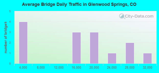
- 197,673Total average daily traffic
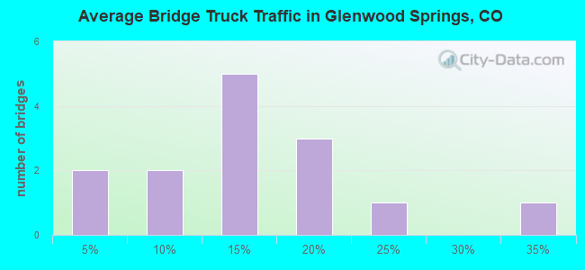
- 19,873Total average daily truck traffic
- National Bridge Inventory (NBI) Registered Bridges for Glenwood Springs
- No street view available for this location
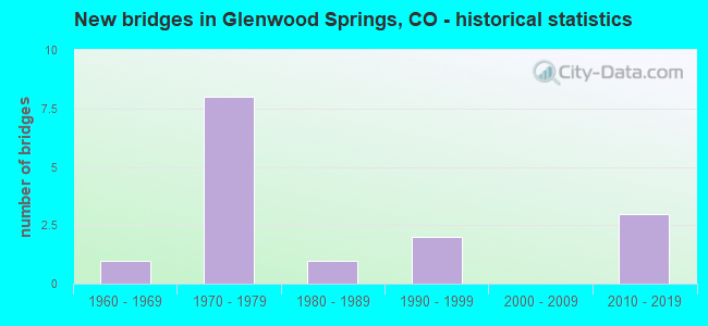
- New bridges - historical statistics
- 11960-1969
- 81970-1979
- 11980-1989
- 21990-1999
- 32010-2019
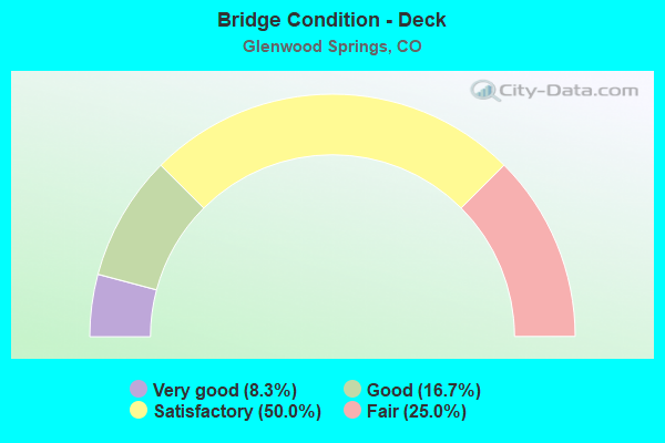
- Bridge Condition - Deck
- 8.3%Very good
- 16.7%Good
- 50.0%Satisfactory
- 25.0%Fair
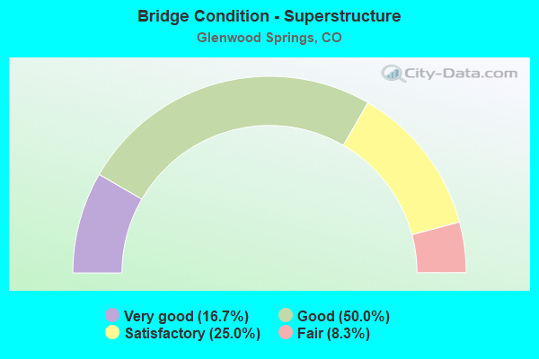
- Bridge Condition - Superstructure
- 16.7%Very good
- 50.0%Good
- 25.0%Satisfactory
- 8.3%Fair
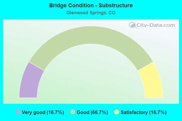
- Bridge Condition - Substructure
- 16.7%Very good
- 66.7%Good
- 16.7%Satisfactory
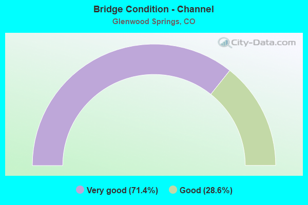
- Bridge Condition - Channel
- 71.4%Very good
- 28.6%Good
Find on map >> Show street view
Structure Number: F-07-AA, Location: BTWN NEW CASTLE & GLENWOO (Lat: 39.571472, Lng: -107.455761), Route carried "on" structure: Interstate 70A, Year Built: 1971, Status: Open, Structure Length: 6.25m (20.51ft), Average Daily Traffic: 15,500 (year 2020), Truck Traffic: 10%, Average Future Daily Traffic: 22,165 (year 2040), Design Load: HS 20+Mod, Features Intersected: UP RR, Facility Carried by Structure: I 70 ML WBND
Minimum Vertical Clearance: 30+ m (98+ ft), Kilometerpoint: 175.169, Lanes on structure: 2, Base Highway Network: Yes, Owner: State Highway Agency, Approaching Roadway Width: 12.8m (42.0ft), Skew: 14 degrees, Material/Design: Steel continuous, Design/Construction: Stringer/Multi-beam, Number Of Spans In Main Unit: 3, Length of Maximum Span: 24.0m (78.7ft), Curb-To-Curb Width: 12.8m (42.0ft), Out-to-Out Width: 13.6m (44.6ft)
Condition: Deck: Satisfactory, Superstructure: Good, Substructure: Good, Operating Rating: 69.3 metric tons, Method Used To Determine Operating Rating: Load Factor (LF), Inventory Rating: 41.5 metric tons, Method Used To Determine Inventory Rating: Load Factor (LF), Structural Evaluation: Better than present minimum criteria, Deck Geometry: Equal to present desirable criteria, Underclear: Better than present minimum criteria, Approach Roadway Alignment: Equal to present desirable criteria, Designated Inspection Frequency: Every 24 months, Inspection Date: August 2020, Deck Structure Type: Concrete Cast-file-Place, Wearing Surface/Protective System: Wearing Surface: Bituminous
Find on map >> Show street view
Structure Number: F-07-AF, Location: W. GLENWOOD INTERCHANGE (Lat: 39.560814, Lng: -107.361519), Route carried "on" structure: Interstate 70A, Year Built: 1970, Status: Open, Structure Length: 3.60m (11.81ft), Average Daily Traffic: 16,500 (year 2020), Truck Traffic: 11%, Average Future Daily Traffic: 20,955 (year 2040), Design Load: HS 20+Mod, Features Intersected: COUNTY ROAD 133, Facility Carried by Structure: I 70 ML WBND
Minimum Vertical Clearance: 30+ m (98+ ft), Kilometerpoint: 184.128, Lanes on structure: 2, Lanes under structure: 3, Base Highway Network: Yes, Owner: State Highway Agency, Approaching Roadway Width: 11.6m (38.1ft), Skew: 10 degrees, Material/Design: Concrete continuous, Design/Construction: Tee Beam, Number Of Spans In Main Unit: 3, Length of Maximum Span: 13.4m (44.0ft), Curb-To-Curb Width: 12.0m (39.4ft), Out-to-Out Width: 12.8m (42.0ft)
Condition: Deck: Satisfactory, Superstructure: Good, Substructure: Good, Operating Rating: 49.9 metric tons, Method Used To Determine Operating Rating: Load Factor (LF), Inventory Rating: 29.9 metric tons, Method Used To Determine Inventory Rating: Load Factor (LF), Structural Evaluation: Better than present minimum criteria, Deck Geometry: Equal to present minimum criteria, Underclear: High priority of corrective action, Approach Roadway Alignment: Equal to present desirable criteria, Designated Inspection Frequency: Every 24 months, Inspection Date: August 2020, Deck Structure Type: Other, Wearing Surface/Protective System: Wearing Surface: Bituminous
Find on map >> Show street view
Structure Number: F-07-AG, Location: W. GLENWOOD INTERCHANGE (Lat: 39.560636, Lng: -107.361539), Route carried "on" structure: Interstate 70A, Year Built: 1970, Status: Open, Structure Length: 3.60m (11.81ft), Average Daily Traffic: 16,500 (year 2020), Truck Traffic: 11%, Average Future Daily Traffic: 20,955 (year 2040), Design Load: HS 20, Features Intersected: COUNTY ROAD 133, Facility Carried by Structure: I 70 ML EBND
Minimum Vertical Clearance: 30+ m (98+ ft), Kilometerpoint: 184.127, Lanes on structure: 2, Lanes under structure: 3, Base Highway Network: Yes, Owner: State Highway Agency, Approaching Roadway Width: 11.6m (38.1ft), Skew: 10 degrees, Material/Design: Concrete continuous, Design/Construction: Tee Beam, Number Of Spans In Main Unit: 3, Length of Maximum Span: 13.4m (44.0ft), Curb-To-Curb Width: 12.0m (39.4ft), Out-to-Out Width: 12.8m (42.0ft)
Condition: Deck: Fair, Superstructure: Satisfactory, Substructure: Satisfactory, Operating Rating: 50.1 metric tons, Method Used To Determine Operating Rating: Load Factor (LF), Inventory Rating: 30.0 metric tons, Method Used To Determine Inventory Rating: Load Factor (LF), Structural Evaluation: Equal to present minimum criteria, Deck Geometry: Equal to present minimum criteria, Underclear: High priority of corrective action, Approach Roadway Alignment: Better than present minimum criteria, Designated Inspection Frequency: Every 24 months, Inspection Date: August 2020, Deck Structure Type: Other, Wearing Surface/Protective System: Wearing Surface: Bituminous
Find on map >> Show street view
Structure Number: F-07-AH, Location: IN GLENWOOD (Lat: 39.553003, Lng: -107.332269), Route carried "on" structure: County highway , Year Built: 1970, Status: Open, Structure Length: 5.78m (18.96ft), Average Daily Traffic: 1,645 (year 2008), Truck Traffic: 9%, Average Future Daily Traffic: 3,455 (year 2028), Design Load: HS 20+Mod, Features Intersected: I 70 ML, Facility Carried by Structure: DEVEREUX ROAD
Minimum Vertical Clearance: 30+ m (98+ ft), Kilometerpoint: 2.952, Lanes on structure: 2, Lanes under structure: 5, Owner: State Highway Agency, Approaching Roadway Width: 8.2m (26.9ft), Material/Design: Concrete continuous, Design/Construction: Box Beam or Girders - Multiple, Number Of Spans In Main Unit: 2, Length of Maximum Span: 28.5m (93.5ft), Curb-To-Curb Width: 8.5m (27.9ft), Out-to-Out Width: 9.3m (30.5ft)
Condition: Deck: Fair, Superstructure: Fair, Substructure: Good, Operating Rating: 43.5 metric tons, Method Used To Determine Operating Rating: Load Factor (LF), Inventory Rating: 25.9 metric tons, Method Used To Determine Inventory Rating: Load Factor (LF), Structural Evaluation: Somewhat better than minimum adequacy, Deck Geometry: Somewhat better than minimum adequacy, Underclear: Better than present minimum criteria, Approach Roadway Alignment: Equal to present minimum criteria, Designated Inspection Frequency: Every 24 months, Inspection Date: August 2020, Deck Structure Type: Other, Wearing Surface/Protective System: Wearing Surface: Bituminous
Find on map >> Show street view
Structure Number: F-07-AI, Location: GLENWOOD SPRINGS (Lat: 39.549533, Lng: -107.328375), Route carried "on" structure: Interstate 70A, Year Built: 1970, Status: Open, Structure Length: 4.33m (14.21ft), Average Daily Traffic: 24,000 (year 2020), Truck Traffic: 12%, Average Future Daily Traffic: 29,760 (year 2040), Design Load: HS 20+Mod, Features Intersected: SH 82 ML, Facility Carried by Structure: I 70 ML
Minimum Vertical Clearance: 30+ m (98+ ft), Kilometerpoint: 187.472, Lanes on structure: 4, Lanes under structure: 3, Base Highway Network: Yes, Owner: State Highway Agency, Approaching Roadway Width: 23.2m (76.1ft), Skew: 31 degrees, Material/Design: Concrete continuous, Design/Construction: Tee Beam, Number Of Spans In Main Unit: 3, Length of Maximum Span: 17.4m (57.1ft), Curb-To-Curb Width: 19.7m (64.6ft), Out-to-Out Width: 20.9m (68.6ft)
Condition: Deck: Fair, Superstructure: Satisfactory, Substructure: Good, Operating Rating: 55.3 metric tons, Method Used To Determine Operating Rating: Load Factor (LF), Inventory Rating: 32.7 metric tons, Method Used To Determine Inventory Rating: Load Factor (LF), Structural Evaluation: Equal to present minimum criteria, Deck Geometry: Equal to present minimum criteria, Underclear: High priority of corrective action, Approach Roadway Alignment: Equal to present desirable criteria, Designated Inspection Frequency: Every 24 months, Inspection Date: August 2020, Deck Structure Type: Other, Wearing Surface/Protective System: Wearing Surface: Bituminous
Find on map >> Show street view
Structure Number: F-07-V, Location: GLENWOOD SPRINGS (Lat: 39.549528, Lng: -107.326369), Route carried "on" structure: State highway 27, Year Built: 2017, Status: Open, Structure Length: 29.91m (98.13ft), Average Daily Traffic: 29,000 (year 2018), Truck Traffic: 4%, Average Future Daily Traffic: 32,190 (year 2038), Design Load: HL 93, Features Intersected: I70 ML,COLORADO RVR,RR, Facility Carried by Structure: SH 82 ML
Minimum Vertical Clearance: 30+ m (98+ ft), Kilometerpoint: 0.486, Lanes on structure: 4, Lanes under structure: 8, Base Highway Network: Yes, Owner: State Highway Agency, Approaching Roadway Width: 17.1m (56.1ft), Skew: 9 degrees, Material/Design: Steel continuous, Design/Construction: Box Beam or Girders - Single/Spread, Number Of Spans In Main Unit: 5, Number Of Approach Spans: 3, Length of Maximum Span: 53.0m (173.9ft), Curb-To-Curb Width: 15.8m (51.8ft), Out-to-Out Width: 17.1m (56.1ft)
Condition: Deck: Good, Superstructure: Good, Substructure: Good, Channel: Very good, Operating Rating: 44.7 metric tons, Method Used To Determine Operating Rating: Load and Resistance Factor Rating (LRFR) rating reported by rating factor(RF) method using HL-93 loadings, Inventory Rating: 32.4 metric tons, Method Used To Determine Inventory Rating: Load and Resistance Factor Rating (LRFR) rating reported by rating factor(RF) method using HL-93 loadings, Structural Evaluation: Better than present minimum criteria, Deck Geometry: Meets minimum limits, Underclear: Meets minimum limits, Waterway Adequacy: Equal to present desirable criteria, Approach Roadway Alignment: Equal to present desirable criteria, Length Of Structure Improvement: 20.64m (67.72ft), Designated Inspection Frequency: Every 24 months, Inspection Date: September 2020, Bridge Improvement Cost: $1,000,000, Roadway Improvement Cost: $100,000, Total Project Cost: $1,500,000, Deck Structure Type: Concrete Cast-file-Place, Wearing Surface/Protective System: Wearing Surface: Epoxy Overlay, Membrane: Epoxy, Deck Protection: Epoxy Coated Reinforcing
Find on map >> Show street view
Structure Number: GAR126-00.02, Location: W. OF CR 117 (Lat: 39.462222, Lng: -107.324444), Route carried "on" structure: County highway , Year Built: 2014, Status: Open, Structure Length: 1.37m (4.49ft), Average Daily Traffic: 155 (year 2021), Truck Traffic: 16%, Average Future Daily Traffic: 197 (year 2041), Features Intersected: Fourmile Creek, Facility Carried by Structure: County Road 126
Minimum Vertical Clearance: 30+ m (98+ ft), Kilometerpoint: 0.024, Lanes on structure: 2, Owner: County Highway Agency, Approaching Roadway Width: 9.4m (30.8ft), Material/Design: Prestressed concrete, Design/Construction: Slab, Number Of Spans In Main Unit: 1, Length of Maximum Span: 12.2m (40.0ft), Curb or Sidewalk Widths: Left: 0.2m (0.7ft), Right: 0.2m (0.7ft), Curb-To-Curb Width: 9.4m (30.8ft), Out-to-Out Width: 11.0m (36.1ft)
Condition: Deck: Very good, Superstructure: Very good, Substructure: Very good, Channel: Very good, Operating Rating: 71.0 metric tons, Method Used To Determine Operating Rating: Load and Resistance Factor Rating (LRFR) rating reported by rating factor(RF) method using HL-93 loadings, Inventory Rating: 44.4 metric tons, Method Used To Determine Inventory Rating: Load and Resistance Factor Rating (LRFR) rating reported by rating factor(RF) method using HL-93 loadings, Structural Evaluation: Equal to present desirable criteria, Deck Geometry: Equal to present minimum criteria, Waterway Adequacy: Equal to present desirable criteria, Approach Roadway Alignment: Equal to present minimum criteria, Designated Inspection Frequency: Every 24 months, Inspection Date: September 2021, Deck Structure Type: Concrete Cast-file-Place, Wearing Surface/Protective System: Wearing Surface: Bituminous, Deck Protection: Epoxy Coated Reinforcing
Find on map >> Show street view
Structure Number: GAR134-04.9, Location: Exit 111 of I-70 (Lat: 39.561778, Lng: -107.407361), Route carried "on" structure: County highway , Year Built: 1980, Year Reconstructed: 1998, Status: Open, Structure Length: 7.61m (24.97ft), Average Daily Traffic: 958 (year 2020), Truck Traffic: 30%, Average Future Daily Traffic: 1,217 (year 2040), Design Load: HS 20, Features Intersected: Colorado River, Facility Carried by Structure: County Road 134
Minimum Vertical Clearance: 30+ m (98+ ft), Kilometerpoint: 7.806, Lanes on structure: 2, Owner: County Highway Agency, Approaching Roadway Width: 7.3m (24.0ft), Material/Design: Steel continuous, Design/Construction: Stringer/Multi-beam, Number Of Spans In Main Unit: 3, Length of Maximum Span: 37.4m (122.7ft), Curb-To-Curb Width: 7.8m (25.6ft), Out-to-Out Width: 8.5m (27.9ft)
Condition: Deck: Satisfactory, Superstructure: Good, Substructure: Satisfactory, Channel: Very good, Operating Rating: 41.9 metric tons, Method Used To Determine Operating Rating: Load Factor (LF), Inventory Rating: 34.5 metric tons, Method Used To Determine Inventory Rating: Load Factor (LF), Structural Evaluation: Equal to present minimum criteria, Deck Geometry: Meets minimum limits, Waterway Adequacy: Equal to present desirable criteria, Approach Roadway Alignment: Somewhat better than minimum adequacy, Designated Inspection Frequency: Every 24 months, Inspection Date: September 2021, Deck Structure Type: Concrete Cast-file-Place, Wearing Surface/Protective System: Wearing Surface: Monolithic Concrete
Find on map >> Show street view
Structure Number: GLNWD-27TH ST R, Location: 0.2 MI W OF HIGHWAY 82 (Lat: 39.525272, Lng: -107.325631), Route carried "on" structure: City street , Year Built: 2019, Status: Open, Structure Length: 5.88m (19.29ft), Average Daily Traffic: 14,921 (year 2021), Truck Traffic: 10%, Average Future Daily Traffic: 18,950 (year 2041), Design Load: HL 93, Features Intersected: ROARING FORK RIVER, Facility Carried by Structure: 27TH STREET
Minimum Vertical Clearance: 30+ m (98+ ft), Kilometerpoint: 0.146, Lanes on structure: 2, Owner: City or Municipal Highway Agency, Approaching Roadway Width: 9.1m (29.9ft), Material/Design: Steel, Design/Construction: Stringer/Multi-beam, Number Of Spans In Main Unit: 1, Length of Maximum Span: 57.9m (190.0ft), Curb-To-Curb Width: 9.1m (29.9ft), Out-to-Out Width: 10.1m (33.1ft)
Condition: Deck: Good, Superstructure: Very good, Substructure: Very good, Channel: Very good, Operating Rating: 55.1 metric tons, Method Used To Determine Operating Rating: Load and Resistance Factor Rating (LRFR) rating reported by rating factor(RF) method using HL-93 loadings, Inventory Rating: 42.1 metric tons, Method Used To Determine Inventory Rating: Load and Resistance Factor Rating (LRFR) rating reported by rating factor(RF) method using HL-93 loadings, Structural Evaluation: Equal to present desirable criteria, Deck Geometry: High priority of corrective action, Waterway Adequacy: Equal to present desirable criteria, Approach Roadway Alignment: Better than present minimum criteria, Designated Inspection Frequency: Every 24 months, Inspection Date: September 2021, Deck Structure Type: Concrete Cast-file-Place, Wearing Surface/Protective System: Wearing Surface: Monolithic Concrete
Find on map >> Show street view
Structure Number: GLNWD-7A, Location: 4 Bl. W. of Pine Street (Lat: 39.546833, Lng: -107.330583), Route carried "on" structure: City street , Year Built: 1991, Status: Open, Structure Length: 6.05m (19.85ft), Average Daily Traffic: 12,878 (year 2021), Truck Traffic: 16%, Average Future Daily Traffic: 16,355 (year 2041), Design Load: HS 20, Features Intersected: Roaring Fork River, Facility Carried by Structure: 7th Street
Minimum Vertical Clearance: 30+ m (98+ ft), Kilometerpoint: 0.143, Lanes on structure: 2, Owner: City or Municipal Highway Agency, Approaching Roadway Width: 7.9m (25.9ft), Material/Design: Steel continuous, Design/Construction: Stringer/Multi-beam, Number Of Spans In Main Unit: 3, Length of Maximum Span: 29.9m (98.1ft), Curb or Sidewalk Widths: Left: 2.5m (8.2ft), Right: 2.5m (8.2ft), Curb-To-Curb Width: 7.9m (25.9ft), Out-to-Out Width: 13.6m (44.6ft)
Condition: Deck: Satisfactory, Superstructure: Good, Substructure: Good, Channel: Good, Operating Rating: 24.7 metric tons, Method Used To Determine Operating Rating: Load Factor (LF), Inventory Rating: 14.8 metric tons, Method Used To Determine Inventory Rating: Load Factor (LF), Structural Evaluation: High priority of corrective action, Deck Geometry: High priority of corrective action, Waterway Adequacy: Equal to present desirable criteria, Approach Roadway Alignment: Equal to present minimum criteria, Length Of Structure Improvement: 6.05m (19.85ft), Designated Inspection Frequency: Every 24 months, Other Special Inspection Frequency: Every 60 months, Inspection Date: September 2021, Other Special Inspection Date: July 2021, Bridge Improvement Cost: $1,021,000, Roadway Improvement Cost: $102,000, Total Project Cost: $1,123,000 ( Estimate for 2017), Deck Structure Type: Concrete Cast-file-Place, Wearing Surface/Protective System: Wearing Surface: Bituminous, Membrane: Preformed Fabric, Deck Protection: Epoxy Coated Reinforcing
Find on map >> Show street view
Structure Number: GLNWD-DEVEREUX, Location: 0.25 Miles South of I-70 (Lat: 39.552222, Lng: -107.336500), Route carried "on" structure: City street , Year Built: 1966, Status: Open, Structure Length: 9.10m (29.86ft), Average Daily Traffic: 1,252 (year 2020), Truck Traffic: 16%, Average Future Daily Traffic: 1,590 (year 2040), Design Load: HS 20, Features Intersected: Colorado River, Facility Carried by Structure: Devereux, AC To RR
Minimum Vertical Clearance: 30+ m (98+ ft), Kilometerpoint: 2.634, Lanes on structure: 2, Owner: City or Municipal Highway Agency, Approaching Roadway Width: 8.5m (27.9ft), Skew: 2 degrees, Material/Design: Prestressed concrete continuous, Design/Construction: Stringer/Multi-beam, Number Of Spans In Main Unit: 3, Length of Maximum Span: 29.3m (96.1ft), Curb or Sidewalk Widths: Left: 0.6m (2.0ft), Right: 0.6m (2.0ft), Curb-To-Curb Width: 7.3m (24.0ft), Out-to-Out Width: 8.6m (28.2ft)
Condition: Deck: Satisfactory, Superstructure: Satisfactory, Substructure: Good, Channel: Good, Operating Rating: 45.4 metric tons, Method Used To Determine Operating Rating: Load Factor (LF), Inventory Rating: 10.7 metric tons, Method Used To Determine Inventory Rating: Load Factor (LF), Structural Evaluation: High priority of corrective action, Deck Geometry: Meets minimum limits, Waterway Adequacy: Equal to present desirable criteria, Approach Roadway Alignment: Somewhat better than minimum adequacy, Length Of Structure Improvement: 9.10m (29.86ft), Designated Inspection Frequency: Every 24 months, Underwater Inspection Frequency: Every 60 months, Inspection Date: September 2021, Underwater Inspection Date: August 2020, Bridge Improvement Cost: $1,600,000, Roadway Improvement Cost: $160,000, Total Project Cost: $1,760,000 ( Estimate for 2017), Deck Structure Type: Concrete Cast-file-Place, Wearing Surface/Protective System: Wearing Surface: Monolithic Concrete
Find on map >> Show street view
Structure Number: GLNWD-MIDAVE, Location: Exit 114 of I-70 (Lat: 39.559500, Lng: -107.360778), Route carried "on" structure: City street , Year Built: 1996, Status: Open, Structure Length: 8.17m (26.80ft), Average Daily Traffic: 16,364 (year 2020), Truck Traffic: 20%, Average Future Daily Traffic: 20,782 (year 2040), Design Load: HS 20, Features Intersected: Colorado River, Facility Carried by Structure: Midland Avenue
Minimum Vertical Clearance: 30+ m (98+ ft), Kilometerpoint: 7.841, Lanes on structure: 3, Owner: City or Municipal Highway Agency, Approaching Roadway Width: 14.0m (45.9ft), Material/Design: Steel continuous, Design/Construction: Stringer/Multi-beam, Number Of Spans In Main Unit: 3, Length of Maximum Span: 59.1m (193.9ft), Curb or Sidewalk Widths: Left: 0.0m, Right: 2.6m (8.5ft), Curb-To-Curb Width: 14.6m (47.9ft), Out-to-Out Width: 18.0m (59.1ft)
Condition: Deck: Satisfactory, Superstructure: Good, Substructure: Good, Channel: Very good, Operating Rating: 66.9 metric tons, Method Used To Determine Operating Rating: Load Factor (LF), Inventory Rating: 40.0 metric tons, Method Used To Determine Inventory Rating: Load Factor (LF), Structural Evaluation: Better than present minimum criteria, Deck Geometry: Somewhat better than minimum adequacy, Waterway Adequacy: Equal to present desirable criteria, Approach Roadway Alignment: Equal to present desirable criteria, Designated Inspection Frequency: Every 24 months, Inspection Date: September 2021, Deck Structure Type: Concrete Cast-file-Place, Wearing Surface/Protective System: Wearing Surface: Bituminous, Membrane: Preformed Fabric, Deck Protection: Epoxy Coated Reinforcing
Find on map >> Show street view
Structure Number: F-07-AG, Location: W. GLENWOOD INTERCHANGE (Lat: 39.560636, Lng: -107.361539), Route carried "under" structure: County highway , Year Built: 1970, Structure Length: 0. m, Features Intersected: COUNTY ROAD 133, Facility Carried by Structure: I 70 ML EBND
Minimum Vertical Clearance: 5.79m (19.00ft), Kilometerpoint: 0.000, Lanes on structure: 2, Lanes under structure: 2, Material/Design: Concrete continuous, Design/Construction: Tee Beam, Length of Maximum Span: 13.4m (44.0ft)
Find on map >> Show street view
Structure Number: F-07-AH, Location: IN GLENWOOD (Lat: 39.553003, Lng: -107.332269), Route carried "under" structure: Interstate 70A, Year Built: 1970, Structure Length: 0. m, Average Daily Traffic: 25,000 (year 2018), Truck Traffic: 9%, Features Intersected: I 70 ML, Facility Carried by Structure: DEVEREUX ROAD
Minimum Vertical Clearance: 5.13m (16.83ft), Kilometerpoint: 2.952, Lanes on structure: 2, Lanes under structure: 5, Material/Design: Concrete continuous, Design/Construction: Box Beam or Girders - Multiple, Length of Maximum Span: 28.5m (93.5ft)
Find on map >> Show street view
Structure Number: F-07-AI, Location: GLENWOOD SPRINGS (Lat: 39.549533, Lng: -107.328375), Route carried "under" structure: State highway 82A, Year Built: 1970, Structure Length: 0. m, Average Daily Traffic: 23,000 (year 2011), Truck Traffic: 4%, Features Intersected: SH 82 ML, Facility Carried by Structure: I 70 ML
Minimum Vertical Clearance: 5.46m (17.91ft), Kilometerpoint: 0.002, Lanes on structure: 4, Lanes under structure: 2, Material/Design: Concrete continuous, Design/Construction: Tee Beam, Length of Maximum Span: 17.4m (57.1ft)