Bridge Statistics for Glen Ridge, Florida (FL)
Condition, Traffic, Stress, Structural Evaluation, Project Costs
- National Bridge Inventory (NBI) Statistics
- 13Number of bridges
- 249ft / 75.6mTotal length
- 268,250Total average daily traffic
- 15,600Total average daily truck traffic
- National Bridge Inventory (NBI) Registered Bridges for Glen Ridge
- No street view available for this location
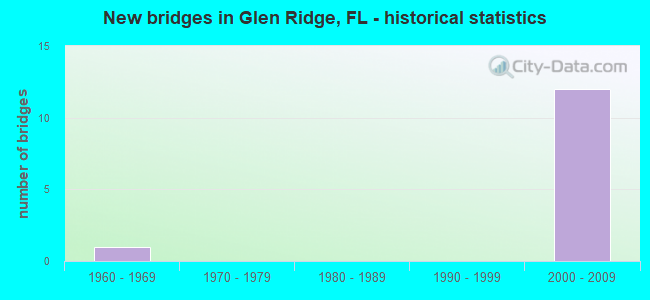
- New bridges - historical statistics
- 11960-1969
- 122000-2009


- Bridge Condition - Deck
- 22.2%Very good
- 55.6%Good
- 22.2%Satisfactory

- Bridge Condition - Superstructure
- 33.3%Very good
- 44.4%Good
- 22.2%Satisfactory

- Bridge Condition - Substructure
- 11.1%Very good
- 88.9%Good

- Bridge Condition - Channel
- 14.3%Excellent
- 57.1%Good
- 28.6%Satisfactory
Find on map >> Show street view
Structure Number: 930466, Location: 1.0mile south of SR-80 (Lat: 26.661944, Lng: -80.088333), Route carried "on" structure: State highway 807, Year Built: 2000, Status: Open, Structure Length: 1.21m (3.97ft), Average Daily Traffic: 31,500 (year 2020), Truck Traffic: 4%, Average Future Daily Traffic: 54,652 (year 2042), Design Load: HS 25 or greater, Features Intersected: L-6 Canal
Minimum Vertical Clearance: 30+ m (98+ ft), Kilometerpoint: 8.269, Lanes on structure: 7, Base Highway Network: Yes, Owner: State Highway Agency, Approaching Roadway Width: 26.1m (85.6ft), Skew: 20 degrees, Material/Design: Prestressed concrete, Design/Construction: Stringer/Multi-beam, Number Of Spans In Main Unit: 1, Length of Maximum Span: 12.1m (39.7ft), Curb or Sidewalk Widths: Left: 2.2m (7.2ft), Right: 2.2m (7.2ft), Curb-To-Curb Width: 30.6m (100.4ft), Out-to-Out Width: 31.5m (103.3ft)
Condition: Deck: Satisfactory, Superstructure: Satisfactory, Substructure: Good, Channel: Excellent, Operating Rating: 46.3 metric tons, Method Used To Determine Operating Rating: Load Factor (LF), Inventory Rating: 27.8 metric tons, Method Used To Determine Inventory Rating: Load Factor (LF), Structural Evaluation: Equal to present minimum criteria, Deck Geometry: Better than present minimum criteria, Waterway Adequacy: Superior to present desirable criteria, Approach Roadway Alignment: Equal to present desirable criteria, Designated Inspection Frequency: Every 24 months, Inspection Date: May 2020, Deck Structure Type: Concrete Precast Panels
Find on map >> Show street view
Structure Number: 930472, Location: SE quadrant PB Int Airprt (Lat: 26.676111, Lng: -80.086111), Route carried "on" structure: Ramp US 98, Year Built: 2002, Status: Open, Structure Length: 6.96m (22.83ft), Average Daily Traffic: 11,000 (year 2020), Truck Traffic: 5%, Average Future Daily Traffic: 19,085 (year 2042), Design Load: HS 20+Mod, Features Intersected: C-51 Canal, Facility Carried by Structure: EBSR80 to SBSR807
Minimum Vertical Clearance: 30+ m (98+ ft), Kilometerpoint: 0.069, Lanes on structure: 1, Owner: State Highway Agency, Approaching Roadway Width: 7.9m (25.9ft), Skew: 9 degrees, Navigation Control: Yes ( Vertical Clearance: 2.2m (7.2ft), Horizontal Clearance: 22.9m (75.1ft)), Material/Design: Prestressed concrete, Design/Construction: Stringer/Multi-beam, Number Of Spans In Main Unit: 3, Length of Maximum Span: 23.3m (76.4ft), Curb-To-Curb Width: 8.4m (27.6ft), Out-to-Out Width: 9.4m (30.8ft)
Condition: Deck: Very good, Superstructure: Very good, Substructure: Good, Channel: Good, Operating Rating: 62.5 metric tons, Method Used To Determine Operating Rating: Load Factor (LF), Inventory Rating: 37.5 metric tons, Method Used To Determine Inventory Rating: Load Factor (LF), Structural Evaluation: Better than present minimum criteria, Deck Geometry: Superior to present desirable criteria, Waterway Adequacy: Superior to present desirable criteria, Approach Roadway Alignment: Equal to present desirable criteria, Designated Inspection Frequency: Every 24 months, Underwater Inspection Frequency: Every 24 months, Inspection Date: October 2020, Underwater Inspection Date: October 2020, Deck Structure Type: Concrete Cast-file-Place
Find on map >> Show street view
Structure Number: 930473, Location: SE quadrant PB Int Airprt (Lat: 26.676069, Lng: -80.085944), Route carried "on" structure: Ramp US 98, Year Built: 2002, Status: Open, Structure Length: 6.92m (22.70ft), Average Daily Traffic: 11,000 (year 2020), Truck Traffic: 5%, Average Future Daily Traffic: 19,085 (year 2042), Design Load: HS 20+Mod, Features Intersected: C-51 Canal, Facility Carried by Structure: SBSR807 to EBSR80
Minimum Vertical Clearance: 30+ m (98+ ft), Kilometerpoint: 0.051, Lanes on structure: 1, Owner: State Highway Agency, Approaching Roadway Width: 7.1m (23.3ft), Skew: 9 degrees, Navigation Control: Yes ( Vertical Clearance: 2.2m (7.2ft), Horizontal Clearance: 13.4m (44.0ft)), Material/Design: Prestressed concrete, Design/Construction: Stringer/Multi-beam, Number Of Spans In Main Unit: 5, Length of Maximum Span: 13.9m (45.6ft), Curb-To-Curb Width: 8.4m (27.6ft), Out-to-Out Width: 9.4m (30.8ft)
Condition: Deck: Good, Superstructure: Very good, Substructure: Good, Channel: Good, Operating Rating: 68.8 metric tons, Method Used To Determine Operating Rating: Load Factor (LF), Inventory Rating: 41.3 metric tons, Method Used To Determine Inventory Rating: Load Factor (LF), Structural Evaluation: Better than present minimum criteria, Deck Geometry: Superior to present desirable criteria, Waterway Adequacy: Superior to present desirable criteria, Approach Roadway Alignment: Equal to present desirable criteria, Designated Inspection Frequency: Every 24 months, Underwater Inspection Frequency: Every 24 months, Inspection Date: October 2020, Underwater Inspection Date: October 2020, Deck Structure Type: Concrete Cast-file-Place
Find on map >> Show street view
Structure Number: 930474, Location: SE quadrant PB Int Airpt (Lat: 26.676244, Lng: -80.082958), Route carried "on" structure: Ramp US 98, Year Built: 2002, Status: Open, Structure Length: 7.25m (23.79ft), Average Daily Traffic: 11,000 (year 2020), Truck Traffic: 5%, Average Future Daily Traffic: 19,085 (year 2042), Design Load: HS 20+Mod, Features Intersected: C-51 Canal, Facility Carried by Structure: NBSR807 to EBSR80
Minimum Vertical Clearance: 30+ m (98+ ft), Kilometerpoint: 0.179, Lanes on structure: 1, Owner: State Highway Agency, Approaching Roadway Width: 7.3m (24.0ft), Skew: 4 degrees, Navigation Control: Yes ( Vertical Clearance: 2.3m (7.5ft), Horizontal Clearance: 12.3m (40.4ft)), Material/Design: Prestressed concrete, Design/Construction: Stringer/Multi-beam, Number Of Spans In Main Unit: 3, Length of Maximum Span: 24.2m (79.4ft), Curb or Sidewalk Widths: Left: 0.0m, Right: 1.8m (5.9ft), Curb-To-Curb Width: 9.0m (29.5ft), Out-to-Out Width: 12.0m (39.4ft)
Condition: Deck: Very good, Superstructure: Very good, Substructure: Good, Channel: Satisfactory, Operating Rating: 72.3 metric tons, Method Used To Determine Operating Rating: Load Factor (LF), Inventory Rating: 45.1 metric tons, Method Used To Determine Inventory Rating: Load Factor (LF), Structural Evaluation: Better than present minimum criteria, Deck Geometry: Superior to present desirable criteria, Waterway Adequacy: Superior to present desirable criteria, Approach Roadway Alignment: Equal to present desirable criteria, Designated Inspection Frequency: Every 24 months, Underwater Inspection Frequency: Every 24 months, Inspection Date: October 2020, Underwater Inspection Date: October 2020, Deck Structure Type: Concrete Cast-file-Place
Find on map >> Show street view
Structure Number: 930475, Location: SE quadrant PB Int Airpt (Lat: 26.676428, Lng: -80.083083), Route carried "on" structure: State highway 807, Year Built: 2002, Status: Open, Structure Length: 15.78m (51.77ft), Average Daily Traffic: 19,500 (year 2020), Truck Traffic: 5%, Average Future Daily Traffic: 33,832 (year 2042), Design Load: HS 20+Mod, Features Intersected: EB SR80 & C-51 Canal
Minimum Vertical Clearance: 30+ m (98+ ft), Kilometerpoint: 0.604, Lanes on structure: 3, Lanes under structure: 4, Base Highway Network: Yes, Owner: State Highway Agency, Approaching Roadway Width: 13.1m (43.0ft), Skew: 5 degrees, Navigation Control: Yes ( Vertical Clearance: 7.4m (24.3ft), Horizontal Clearance: 12.3m (40.4ft)), Material/Design: Prestressed concrete, Design/Construction: Stringer/Multi-beam, Number Of Spans In Main Unit: 4, Length of Maximum Span: 45.3m (148.6ft), Curb or Sidewalk Widths: Left: 0.0m, Right: 1.8m (5.9ft), Curb-To-Curb Width: 13.7m (44.9ft), Out-to-Out Width: 19.0m (62.3ft)
Condition: Deck: Good, Superstructure: Good, Substructure: Good, Channel: Good, Operating Rating: 55.3 metric tons, Method Used To Determine Operating Rating: Load Factor (LF), Inventory Rating: 34.5 metric tons, Method Used To Determine Inventory Rating: Load Factor (LF), Structural Evaluation: Better than present minimum criteria, Deck Geometry: Somewhat better than minimum adequacy, Underclear: Superior to present desirable criteria, Waterway Adequacy: Superior to present desirable criteria, Approach Roadway Alignment: Equal to present desirable criteria, Designated Inspection Frequency: Every 24 months, Underwater Inspection Frequency: Every 24 months, Inspection Date: September 2020, Underwater Inspection Date: September 2020, Deck Structure Type: Concrete Cast-file-Place
Find on map >> Show street view
Structure Number: 930476, Location: SE quadrant PB Int Airpt (Lat: 26.677128, Lng: -80.081614), Route carried "on" structure: State highway 807, Year Built: 2002, Status: Open, Structure Length: 6.34m (20.80ft), Average Daily Traffic: 19,500 (year 2020), Truck Traffic: 5%, Average Future Daily Traffic: 33,832 (year 2042), Design Load: HS 20+Mod, Features Intersected: WB SR 80
Minimum Vertical Clearance: 30+ m (98+ ft), Kilometerpoint: 0.830, Lanes on structure: 3, Lanes under structure: 4, Base Highway Network: Yes, Owner: State Highway Agency, Approaching Roadway Width: 13.1m (43.0ft), Skew: 5 degrees, Material/Design: Prestressed concrete, Design/Construction: Stringer/Multi-beam, Number Of Spans In Main Unit: 2, Length of Maximum Span: 40.5m (132.9ft), Curb or Sidewalk Widths: Left: 0.0m, Right: 1.8m (5.9ft), Curb-To-Curb Width: 13.7m (44.9ft), Out-to-Out Width: 19.0m (62.3ft)
Condition: Deck: Good, Superstructure: Good, Substructure: Good, Operating Rating: 87.0 metric tons, Method Used To Determine Operating Rating: Load Factor (LF), Inventory Rating: 52.2 metric tons, Method Used To Determine Inventory Rating: Load Factor (LF), Structural Evaluation: Better than present minimum criteria, Deck Geometry: Somewhat better than minimum adequacy, Underclear: Meets minimum limits, Approach Roadway Alignment: Equal to present desirable criteria, Designated Inspection Frequency: Every 24 months, Inspection Date: October 2020, Deck Structure Type: Concrete Cast-file-Place
Find on map >> Show street view
Structure Number: 930532, Location: SE quadrant PB Int Airpt (Lat: 26.676433, Lng: -80.083428), Route carried "on" structure: State highway 807, Year Built: 2002, Status: Open, Structure Length: 15.78m (51.77ft), Average Daily Traffic: 19,500 (year 2020), Truck Traffic: 5%, Average Future Daily Traffic: 33,832 (year 2042), Design Load: HS 20+Mod, Features Intersected: EB SR80 & C-51 Canal
Minimum Vertical Clearance: 5.09m (16.70ft), Kilometerpoint: 0.576, Lanes on structure: 3, Lanes under structure: 4, Base Highway Network: Yes, Owner: State Highway Agency, Approaching Roadway Width: 13.8m (45.3ft), Skew: 5 degrees, Navigation Control: Yes ( Vertical Clearance: 7.4m (24.3ft), Horizontal Clearance: 12.3m (40.4ft)), Material/Design: Prestressed concrete, Design/Construction: Stringer/Multi-beam, Number Of Spans In Main Unit: 4, Length of Maximum Span: 45.3m (148.6ft), Curb or Sidewalk Widths: Left: 1.8m (5.9ft), Right: 0.0m, Curb-To-Curb Width: 13.7m (44.9ft), Out-to-Out Width: 19.0m (62.3ft)
Condition: Deck: Good, Superstructure: Good, Substructure: Good, Channel: Satisfactory, Operating Rating: 70.9 metric tons, Method Used To Determine Operating Rating: Load Factor (LF), Inventory Rating: 44.2 metric tons, Method Used To Determine Inventory Rating: Load Factor (LF), Structural Evaluation: Better than present minimum criteria, Deck Geometry: Somewhat better than minimum adequacy, Underclear: Superior to present desirable criteria, Waterway Adequacy: Superior to present desirable criteria, Approach Roadway Alignment: Equal to present desirable criteria, Designated Inspection Frequency: Every 24 months, Underwater Inspection Frequency: Every 24 months, Inspection Date: September 2020, Underwater Inspection Date: September 2020, Deck Structure Type: Concrete Cast-file-Place
Find on map >> Show street view
Structure Number: 930533, Location: SE quadrant PB Int Airpt (Lat: 26.677256, Lng: -80.081742), Route carried "on" structure: State highway 807, Year Built: 2002, Status: Open, Structure Length: 6.34m (20.80ft), Average Daily Traffic: 19,500 (year 2020), Truck Traffic: 5%, Average Future Daily Traffic: 33,832 (year 2042), Design Load: HS 20+Mod, Features Intersected: WB SR 80
Minimum Vertical Clearance: 30+ m (98+ ft), Kilometerpoint: 0.818, Lanes on structure: 3, Lanes under structure: 4, Base Highway Network: Yes, Owner: State Highway Agency, Approaching Roadway Width: 13.8m (45.3ft), Skew: 5 degrees, Material/Design: Prestressed concrete, Design/Construction: Stringer/Multi-beam, Number Of Spans In Main Unit: 2, Length of Maximum Span: 40.5m (132.9ft), Curb or Sidewalk Widths: Left: 1.8m (5.9ft), Right: 0.0m, Curb-To-Curb Width: 13.7m (44.9ft), Out-to-Out Width: 19.0m (62.3ft)
Condition: Deck: Good, Superstructure: Good, Substructure: Very good, Operating Rating: 87.0 metric tons, Method Used To Determine Operating Rating: Load Factor (LF), Inventory Rating: 52.2 metric tons, Method Used To Determine Inventory Rating: Load Factor (LF), Structural Evaluation: Better than present minimum criteria, Deck Geometry: Somewhat better than minimum adequacy, Underclear: Meets minimum limits, Approach Roadway Alignment: Equal to present desirable criteria, Designated Inspection Frequency: Every 24 months, Inspection Date: October 2020, Deck Structure Type: Concrete Cast-file-Place
Find on map >> Show street view
Structure Number: 934201, Location: 500FT WEST OF I-95 (Lat: 26.666019, Lng: -80.073914), Route carried "on" structure: County highway , Year Built: 1967, Status: Open, Structure Length: 9.00m (29.53ft), Average Daily Traffic: 11,000 (year 2020), Truck Traffic: 3%, Average Future Daily Traffic: 19,085 (year 2042), Design Load: HS 20, Features Intersected: WPB CANAL C-51, Facility Carried by Structure: SUMMIT BLVD
Minimum Vertical Clearance: 30+ m (98+ ft), Kilometerpoint: 3.116, Lanes on structure: 4, Owner: County Highway Agency, Approaching Roadway Width: 15.9m (52.2ft), Skew: 3 degrees, Material/Design: Steel, Design/Construction: Stringer/Multi-beam, Number Of Spans In Main Unit: 7, Length of Maximum Span: 13.0m (42.7ft), Curb or Sidewalk Widths: Left: 1.5m (4.9ft), Right: 1.5m (4.9ft), Curb-To-Curb Width: 15.9m (52.2ft), Out-to-Out Width: 19.1m (62.7ft)
Condition: Deck: Satisfactory, Superstructure: Satisfactory, Substructure: Good, Channel: Good, Operating Rating: 64.4 metric tons, Method Used To Determine Operating Rating: Load Factor (LF), Inventory Rating: 38.6 metric tons, Method Used To Determine Inventory Rating: Load Factor (LF), Structural Evaluation: Equal to present minimum criteria, Deck Geometry: Meets minimum limits, Waterway Adequacy: Equal to present desirable criteria, Approach Roadway Alignment: Equal to present desirable criteria, Designated Inspection Frequency: Every 24 months, Underwater Inspection Frequency: Every 24 months, Inspection Date: March 2020, Underwater Inspection Date: March 2020, Deck Structure Type: Concrete Cast-file-Place
Find on map >> Show street view
Structure Number: 930475, Location: SE quadrant PB Int Airpt (Lat: 26.676428, Lng: -80.083083), Route carried "under" structure: US 98, Year Built: 2002, Structure Length: 0. m, Average Daily Traffic: 24,000 (year 2018), Truck Traffic: 5%, Features Intersected: EB SR80 & C-51 Canal, Facility Carried by Structure: NB SR 807
Minimum Vertical Clearance: 7.41m (24.31ft), Kilometerpoint: 0.000, Lanes on structure: 3, Lanes under structure: 4, Material/Design: Prestressed concrete, Design/Construction: Stringer/Multi-beam, Length of Maximum Span: 45.3m (148.6ft)
Find on map >> Show street view
Structure Number: 930476, Location: SE quadrant PB Int Airpt (Lat: 26.677128, Lng: -80.081614), Route carried "under" structure: US 98, Year Built: 2002, Structure Length: 0. m, Average Daily Traffic: 30,250 (year 2020), Truck Traffic: 8%, Features Intersected: WB SR 80, Facility Carried by Structure: NB SR 807
Minimum Vertical Clearance: 7.83m (25.69ft), Kilometerpoint: 30.816, Lanes on structure: 3, Lanes under structure: 4, Material/Design: Prestressed concrete, Design/Construction: Stringer/Multi-beam, Length of Maximum Span: 40.5m (132.9ft)
Find on map >> Show street view
Structure Number: 930532, Location: SE quadrant PB Int Airpt (Lat: 26.676433, Lng: -80.083428), Route carried "under" structure: US 98, Year Built: 2002, Structure Length: 0. m, Average Daily Traffic: 30,250 (year 2020), Truck Traffic: 8%, Features Intersected: EB SR80 & C-51 Canal, Facility Carried by Structure: SB SR 807
Minimum Vertical Clearance: 7.43m (24.38ft), Kilometerpoint: 30.708, Lanes on structure: 3, Lanes under structure: 4, Material/Design: Prestressed concrete, Design/Construction: Stringer/Multi-beam, Length of Maximum Span: 45.3m (148.6ft)
Find on map >> Show street view
Structure Number: 930533, Location: SE quadrant PB Int Airpt (Lat: 26.677256, Lng: -80.081742), Route carried "under" structure: US 98, Year Built: 2002, Structure Length: 0. m, Average Daily Traffic: 30,250 (year 2020), Truck Traffic: 8%, Features Intersected: WB SR 80, Facility Carried by Structure: SB SR 807
Minimum Vertical Clearance: 7.85m (25.75ft), Kilometerpoint: 30.792, Lanes on structure: 3, Lanes under structure: 4, Material/Design: Prestressed concrete, Design/Construction: Stringer/Multi-beam, Length of Maximum Span: 40.5m (132.9ft)