Bridge Statistics for Glen Avon, California (CA)
Condition, Traffic, Stress, Structural Evaluation, Project Costs
- National Bridge Inventory (NBI) Statistics
- 13Number of bridges
- 98ft / 29.9mTotal length
- 1,041,514Total average daily traffic
- 125,641Total average daily truck traffic
- National Bridge Inventory (NBI) Registered Bridges for Glen Avon
- No street view available for this location
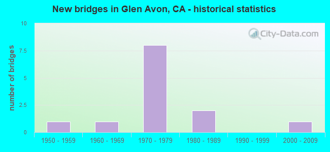
- New bridges - historical statistics
- 11950-1959
- 11960-1969
- 81970-1979
- 21980-1989
- 12000-2009

- Reconstructed bridges - Historical Statistics
- 21970-1979
- 01980-1989
- 01990-1999
- 22000-2009


- Bridge Condition - Deck
- 28.6%Good
- 71.4%Fair

- Bridge Condition - Substructure
- 85.7%Good
- 14.3%Fair

- Bridge Condition - Channel
- 66.7%Excellent
- 33.3%Very good
Find on map >> Show street view
Structure Number: 56 0526, Location: 08-RIV-060-R3.75 (Lat: 34.019067, Lng: -117.494128), Route carried "on" structure: State highway 60, Year Built: 1975, Year Reconstructed: 2008, Status: Open, Structure Length: 4.08m (13.39ft), Average Daily Traffic: 138,000 (year 2016), Truck Traffic: 13%, Average Future Daily Traffic: 204,714 (year 2038), Design Load: HS 20, Features Intersected: CAMPBELL STREET
Minimum Vertical Clearance: 30+ m (98+ ft), Kilometerpoint: 3.750, Lanes on structure: 10, Lanes under structure: 2, Base Highway Network: Yes (, Subroute: 1), Owner: State Highway Agency, Approaching Roadway Width: 24.2m (79.4ft), Skew: 30 degrees, Material/Design: Prestressed concrete, Design/Construction: Box Beam or Girders - Multiple, Number Of Spans In Main Unit: 1, Length of Maximum Span: 40.8m (133.9ft), Curb-To-Curb Width: 50.0m (164.0ft), Out-to-Out Width: 50.0m (164.0ft)
Condition: Deck: Fair, Superstructure: Good, Substructure: Good, Operating Rating: 99.8 metric tons, Method Used To Determine Operating Rating: Load Factor (LF), Inventory Rating: 32.4 metric tons, Method Used To Determine Inventory Rating: Load Factor (LF), Structural Evaluation: Better than present minimum criteria, Deck Geometry: Superior to present desirable criteria, Underclear: Meets minimum limits, Approach Roadway Alignment: Equal to present desirable criteria, Designated Inspection Frequency: Every 24 months, Inspection Date: December 2021, Deck Structure Type: Concrete Cast-file-Place
Find on map >> Show street view
Structure Number: 56 0528, Location: 08-RIV-060-R5.58 (Lat: 34.016067, Lng: -117.462786), Route carried "on" structure: State highway 60, Year Built: 1975, Year Reconstructed: 2008, Status: Open, Structure Length: 5.85m (19.19ft), Average Daily Traffic: 242,000 (year 2019), Truck Traffic: 13%, Average Future Daily Traffic: 285,000 (year 2040), Design Load: HS 20, Features Intersected: PYRITE STREET
Minimum Vertical Clearance: 30+ m (98+ ft), Kilometerpoint: 5.580, Lanes on structure: 10, Lanes under structure: 2, Base Highway Network: Yes (, Subroute: 1), Owner: State Highway Agency, Approaching Roadway Width: 24.2m (79.4ft), Skew: 31 degrees, Material/Design: Prestressed concrete continuous, Design/Construction: Box Beam or Girders - Multiple, Number Of Spans In Main Unit: 2, Length of Maximum Span: 34.7m (113.8ft), Curb-To-Curb Width: 48.5m (159.1ft), Out-to-Out Width: 50.0m (164.0ft)
Condition: Deck: Fair, Superstructure: Good, Substructure: Good, Operating Rating: 99.8 metric tons, Method Used To Determine Operating Rating: Load Factor (LF), Inventory Rating: 32.4 metric tons, Method Used To Determine Inventory Rating: Load Factor (LF), Structural Evaluation: Better than present minimum criteria, Deck Geometry: Superior to present desirable criteria, Underclear: Meets minimum limits, Approach Roadway Alignment: Equal to present desirable criteria, Designated Inspection Frequency: Every 24 months, Inspection Date: June 2021, Deck Structure Type: Concrete Cast-file-Place
Find on map >> Show street view
Structure Number: 56 0643, Location: 08-RIV-060-R3.03 (Lat: 34.019131, Lng: -117.507019), Route carried "on" structure: County highway R162, Year Built: 1971, Status: Open, Structure Length: 7.22m (23.69ft), Average Daily Traffic: 36,055 (year 2016), Truck Traffic: 4%, Average Future Daily Traffic: 38,000 (year 2038), Design Load: HS 20, Features Intersected: STATE ROUTE 60, Facility Carried by Structure: COUNTRY VILLAGE RD
Minimum Vertical Clearance: 30+ m (98+ ft), Kilometerpoint: 0.000, Lanes on structure: 5, Lanes under structure: 10, Owner: State Highway Agency, Approaching Roadway Width: 23.2m (76.1ft), Skew: 1 degrees, Material/Design: Prestressed concrete continuous, Design/Construction: Stringer/Multi-beam, Number Of Spans In Main Unit: 2, Length of Maximum Span: 36.0m (118.1ft), Curb or Sidewalk Widths: Left: 1.5m (4.9ft), Right: 0.0m, Curb-To-Curb Width: 23.2m (76.1ft), Out-to-Out Width: 25.3m (83.0ft)
Condition: Deck: Fair, Superstructure: Good, Substructure: Good, Operating Rating: 51.8 metric tons, Method Used To Determine Operating Rating: Load and Resistance Factor Rating (LRFR) rating reported by rating factor(RF) method using HL-93 loadings, Inventory Rating: 24.9 metric tons, Method Used To Determine Inventory Rating: Load and Resistance Factor Rating (LRFR) rating reported by rating factor(RF) method using HL-93 loadings, Structural Evaluation: Equal to present minimum criteria, Deck Geometry: Better than present minimum criteria, Underclear: Equal to present minimum criteria, Approach Roadway Alignment: Equal to present desirable criteria, Designated Inspection Frequency: Every 24 months, Inspection Date: December 2021, Deck Structure Type: Concrete Cast-file-Place
Find on map >> Show street view
Structure Number: 56 0645, Location: 08-RIV-060-R2.64 (Lat: 34.018361, Lng: -117.513617), Route carried "on" structure: State highway 60, Year Built: 1970, Year Reconstructed: 1975, Status: Open, Structure Length: 3.82m (12.53ft), Average Daily Traffic: 170,000 (year 2016), Truck Traffic: 13%, Average Future Daily Traffic: 183,516 (year 2038), Design Load: HS 20, Features Intersected: SAN SEVAINE CHANNEL
Minimum Vertical Clearance: 30+ m (98+ ft), Kilometerpoint: 2.640, Lanes on structure: 10, Base Highway Network: Yes (, Subroute: 1), Owner: State Highway Agency, Approaching Roadway Width: 24.2m (79.4ft), Skew: 30 degrees, Material/Design: Prestressed concrete, Design/Construction: Box Beam or Girders - Multiple, Number Of Spans In Main Unit: 1, Length of Maximum Span: 37.6m (123.4ft), Curb-To-Curb Width: 48.7m (159.8ft), Out-to-Out Width: 50.0m (164.0ft)
Condition: Deck: Fair, Superstructure: Good, Substructure: Good, Channel: Excellent, Operating Rating: 41.1 metric tons, Method Used To Determine Operating Rating: Load and Resistance Factor Rating (LRFR) rating reported by rating factor(RF) method using HL-93 loadings, Inventory Rating: 28.5 metric tons, Method Used To Determine Inventory Rating: Load and Resistance Factor Rating (LRFR) rating reported by rating factor(RF) method using HL-93 loadings, Structural Evaluation: Better than present minimum criteria, Deck Geometry: Superior to present desirable criteria, Waterway Adequacy: Equal to present desirable criteria, Approach Roadway Alignment: Equal to present desirable criteria, Designated Inspection Frequency: Every 24 months, Inspection Date: December 2021, Deck Structure Type: Concrete Cast-file-Place
Find on map >> Show street view
Structure Number: 56C0142, Location: 0.1 MI. NW/O BELLEGRAVE (Lat: 34.007242, Lng: -117.504739), Route carried "on" structure: County highway , Year Built: 1954, Year Reconstructed: 1970, Status: Open, Structure Length: 1.62m (5.31ft), Average Daily Traffic: 26,000 (year 2011), Truck Traffic: 3%, Average Future Daily Traffic: 53,226 (year 2038), Features Intersected: SAN SEVAINE CHANNEL, Facility Carried by Structure: VAN BUREN BOULEVRD
Minimum Vertical Clearance: 30+ m (98+ ft), Kilometerpoint: 0.000, Lanes on structure: 4, Base Highway Network: Yes, Owner: County Highway Agency, Approaching Roadway Width: 22.6m (74.1ft), Skew: 20 degrees, Material/Design: Concrete, Design/Construction: Culvert, Number Of Spans In Main Unit: 5, Length of Maximum Span: 3.0m (9.8ft), Curb or Sidewalk Widths: Left: 0.2m (0.7ft), Right: 0.2m (0.7ft)
Condition: Channel: Very good, Culverts: Satisfactory, Operating Rating: 40.5 metric tons, Method Used To Determine Operating Rating: Field evaluation and documented engineering judgment, Inventory Rating: 24.3 metric tons, Method Used To Determine Inventory Rating: Field evaluation and documented engineering judgment, Structural Evaluation: Equal to present minimum criteria, Waterway Adequacy: Equal to present minimum criteria, Approach Roadway Alignment: Equal to present desirable criteria, Designated Inspection Frequency: Every 24 months, Inspection Date: March 2020
Find on map >> Show street view
Structure Number: 56C0206, Location: 0.4 MI. SW/O MISSION BLVD (Lat: 34.009453, Lng: -117.491906), Route carried "on" structure: County highway , Year Built: 1966, Status: Open, Structure Length: 1.07m (3.51ft), Average Daily Traffic: 3,000 (year 2012), Truck Traffic: 2%, Average Future Daily Traffic: 6,141 (year 2040), Features Intersected: BLY CHANNEL, Facility Carried by Structure: BELLEGRAVE AVENUE
Minimum Vertical Clearance: 30+ m (98+ ft), Kilometerpoint: 0.000, Lanes on structure: 2, Owner: County Highway Agency, Approaching Roadway Width: 12.2m (40.0ft), Skew: 1 degrees, Material/Design: Prestressed concrete, Design/Construction: Slab, Number Of Spans In Main Unit: 1, Length of Maximum Span: 10.1m (33.1ft), Curb or Sidewalk Widths: Left: 0.0m, Right: 1.7m (5.6ft), Curb-To-Curb Width: 21.2m (69.6ft), Out-to-Out Width: 23.2m (76.1ft)
Condition: Deck: Good, Superstructure: Good, Substructure: Good, Channel: Excellent, Operating Rating: 34.7 metric tons, Method Used To Determine Operating Rating: Field evaluation and documented engineering judgment, Inventory Rating: 20.7 metric tons, Method Used To Determine Inventory Rating: Field evaluation and documented engineering judgment, Structural Evaluation: Somewhat better than minimum adequacy, Deck Geometry: Superior to present desirable criteria, Waterway Adequacy: Superior to present desirable criteria, Approach Roadway Alignment: Equal to present desirable criteria, Designated Inspection Frequency: Every 24 months, Inspection Date: April 2020, Deck Structure Type: Concrete Precast Panels, Wearing Surface/Protective System: Wearing Surface: Bituminous
Find on map >> Show street view
Structure Number: 56C0365, Location: 0.7 MI. E/O ETIWANDA AVE. (Lat: 34.014364, Lng: -117.512625), Route carried "on" structure: County highway , Year Built: 1984, Status: Open, Structure Length: 2.87m (9.42ft), Average Daily Traffic: 5,644 (year 2009), Truck Traffic: 1%, Average Future Daily Traffic: 10,408 (year 2038), Design Load: HS 20, Features Intersected: SAN SEVAINE CHANNEL, Facility Carried by Structure: SAN SEVAINE WAY
Minimum Vertical Clearance: 30+ m (98+ ft), Kilometerpoint: 0.000, Lanes on structure: 4, Owner: County Highway Agency, Approaching Roadway Width: 19.6m (64.3ft), Skew: 4 degrees, Material/Design: Concrete continuous, Design/Construction: Slab, Number Of Spans In Main Unit: 3, Length of Maximum Span: 9.4m (30.8ft), Curb or Sidewalk Widths: Left: 0.3m (1.0ft), Right: 1.7m (5.6ft), Curb-To-Curb Width: 19.6m (64.3ft), Out-to-Out Width: 21.9m (71.9ft)
Condition: Deck: Good, Superstructure: Good, Substructure: Good, Channel: Excellent, Operating Rating: 83.9 metric tons, Method Used To Determine Operating Rating: Load Factor (LF), Inventory Rating: 50.2 metric tons, Method Used To Determine Inventory Rating: Load Factor (LF), Structural Evaluation: Better than present minimum criteria, Deck Geometry: Better than present minimum criteria, Waterway Adequacy: Superior to present desirable criteria, Approach Roadway Alignment: Better than present minimum criteria, Designated Inspection Frequency: Every 48 months, Inspection Date: March 2018, Deck Structure Type: Concrete Cast-file-Place, Wearing Surface/Protective System: Wearing Surface: Bituminous
Find on map >> Show street view
Structure Number: 56C0471, Location: 0.7 MI. N/O ROUTE 60 FWY. (Lat: 34.028311, Lng: -117.506850), Route carried "on" structure: County highway , Year Built: 1984, Status: Open, Structure Length: 2.05m (6.73ft), Average Daily Traffic: 28,884 (year 2011), Truck Traffic: 20%, Average Future Daily Traffic: 66,000 (year 2038), Design Load: HS 20, Features Intersected: DECLEZ CHANNEL, Facility Carried by Structure: COUNTRY VILLAGE RD
Minimum Vertical Clearance: 30+ m (98+ ft), Kilometerpoint: 0.000, Lanes on structure: 3, Owner: County Highway Agency, Approaching Roadway Width: 15.2m (49.9ft), Skew: 4 degrees, Material/Design: Prestressed concrete, Design/Construction: Box Beam or Girders - Multiple, Number Of Spans In Main Unit: 1, Length of Maximum Span: 18.9m (62.0ft), Curb or Sidewalk Widths: Left: 0.0m, Right: 1.5m (4.9ft), Curb-To-Curb Width: 15.2m (49.9ft), Out-to-Out Width: 17.3m (56.8ft)
Condition: Deck: Fair, Superstructure: Good, Substructure: Fair, Channel: Very good, Operating Rating: 54.1 metric tons, Method Used To Determine Operating Rating: Assigned rating based on Load Factor Design (LFD) reported in metric tons, Inventory Rating: 32.4 metric tons, Method Used To Determine Inventory Rating: Assigned rating based on Load Factor Design (LFD) reported in metric tons, Structural Evaluation: Somewhat better than minimum adequacy, Deck Geometry: Equal to present minimum criteria, Waterway Adequacy: Equal to present desirable criteria, Approach Roadway Alignment: Equal to present desirable criteria, Designated Inspection Frequency: Every 24 months, Inspection Date: March 2020, Deck Structure Type: Concrete Cast-file-Place
Find on map >> Show street view
Structure Number: 56C0576, Location: 0.15 MI NW/O BELLEGRAVE (Lat: 34.007403, Lng: -117.504625), Route carried "on" structure: County highway , Year Built: 2006, Status: Open, Structure Length: 1.36m (4.46ft), Average Daily Traffic: 28,931 (year 2009), Truck Traffic: 3%, Average Future Daily Traffic: 53,000 (year 2038), Features Intersected: SAN SEVAINE CHANNEL, Facility Carried by Structure: VAN BUREN BLVD.
Minimum Vertical Clearance: 30+ m (98+ ft), Kilometerpoint: 0.000, Lanes on structure: 4, Base Highway Network: Yes, Owner: County Highway Agency, Approaching Roadway Width: 22.6m (74.1ft), Skew: 21 degrees, Material/Design: Concrete, Design/Construction: Culvert, Number Of Spans In Main Unit: 2, Length of Maximum Span: 6.4m (21.0ft), Curb or Sidewalk Widths: Left: 0.2m (0.7ft), Right: 0.2m (0.7ft)
Condition: Channel: Excellent, Culverts: Satisfactory, Operating Rating: 54.1 metric tons, Method Used To Determine Operating Rating: Field evaluation and documented engineering judgment, Inventory Rating: 32.4 metric tons, Method Used To Determine Inventory Rating: Field evaluation and documented engineering judgment, Structural Evaluation: Equal to present minimum criteria, Waterway Adequacy: Equal to present desirable criteria, Approach Roadway Alignment: Equal to present desirable criteria, Designated Inspection Frequency: Every 48 months, Inspection Date: March 2018
Find on map >> Show street view
Structure Number: 56 0526, Location: 08-RIV-060-R3.75 (Lat: 34.019067, Lng: -117.494128), Route carried "under" structure: County highway R170, Year Built: 1975, Structure Length: 0. m, Average Daily Traffic: 10,000 (year 2016), Truck Traffic: 7%, Features Intersected: CAMPBELL STREET, Facility Carried by Structure: STATE ROUTE 60
Minimum Vertical Clearance: 4.75m (15.58ft), Kilometerpoint: 0.000, Lanes on structure: 10, Lanes under structure: 2, Material/Design: Prestressed concrete, Design/Construction: Box Beam or Girders - Multiple, Length of Maximum Span: 40.8m (133.9ft)
Find on map >> Show street view
Structure Number: 56 0528, Location: 08-RIV-060-R5.58 (Lat: 34.016067, Lng: -117.462786), Route carried "under" structure: County highway R169, Year Built: 1975, Structure Length: 0. m, Average Daily Traffic: 13,000 (year 2020), Truck Traffic: 2%, Features Intersected: PYRITE STREET, Facility Carried by Structure: STATE ROUTE 60
Minimum Vertical Clearance: 5.41m (17.75ft), Kilometerpoint: 0.000, Lanes on structure: 10, Lanes under structure: 2, Material/Design: Prestressed concrete continuous, Design/Construction: Box Beam or Girders - Multiple, Length of Maximum Span: 34.7m (113.8ft)
Find on map >> Show street view
Structure Number: 56 0643, Location: 08-RIV-060-R3.03 (Lat: 34.019131, Lng: -117.507019), Route carried "under" structure: State highway 60, Year Built: 1971, Structure Length: 0. m, Average Daily Traffic: 170,000 (year 2016), Truck Traffic: 13%, Features Intersected: STATE ROUTE 60, Facility Carried by Structure: COUNTRY VILLAGE RD
Minimum Vertical Clearance: 5.03m (16.50ft), Kilometerpoint: 3.030, Lanes on structure: 5, Lanes under structure: 10, Material/Design: Prestressed concrete continuous, Design/Construction: Stringer/Multi-beam, Length of Maximum Span: 36.0m (118.1ft)
Find on map >> Show street view
Structure Number: 56 066, Location: 08-RIV-060-R4.55 (Lat: 34.019522, Lng: -117.480650), Route carried "under" structure: State highway 60, Year Built: 1975, Structure Length: 0. m, Average Daily Traffic: 170,000 (year 2016), Truck Traffic: 13%, Features Intersected: STATE ROUTE 60, Facility Carried by Structure: PEDLEY ROAD
Minimum Vertical Clearance: 6.32m (20.73ft), Kilometerpoint: 4.550, Lanes on structure: 2, Lanes under structure: 10, Material/Design: Prestressed concrete continuous, Design/Construction: Box Beam or Girders - Multiple, Length of Maximum Span: 41.1m (134.8ft)