Bridge Statistics for Glasgow, Delaware (DE)
Condition, Traffic, Stress, Structural Evaluation, Project Costs
- National Bridge Inventory (NBI) Statistics
- 10Number of bridges
- 246ft / 74.8mTotal length
- $1,779,000Total costs
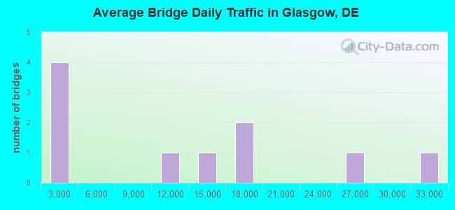
- 119,634Total average daily traffic
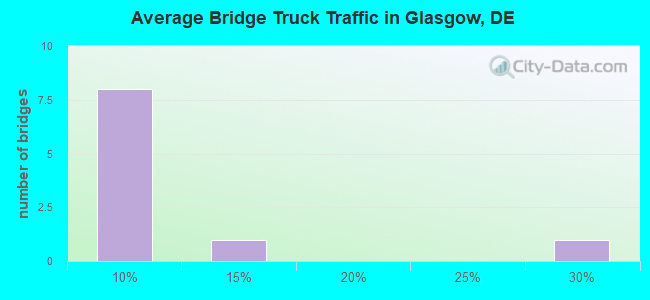
- 14,602Total average daily truck traffic
- National Bridge Inventory (NBI) Registered Bridges for Glasgow
- No street view available for this location
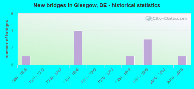
- New bridges - historical statistics
- 11920-1929
- 41950-1959
- 11980-1989
- 31990-1999
- 12010-2019
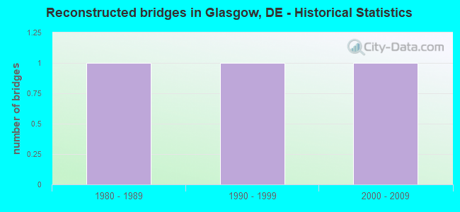
- Reconstructed bridges - Historical Statistics
- 11980-1989
- 11990-1999
- 12000-2009
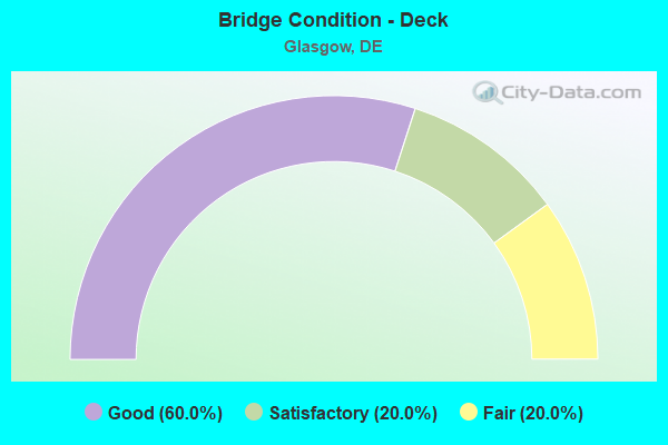
- Bridge Condition - Deck
- 60.0%Good
- 20.0%Satisfactory
- 20.0%Fair
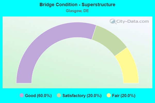
- Bridge Condition - Superstructure
- 60.0%Good
- 20.0%Satisfactory
- 20.0%Fair
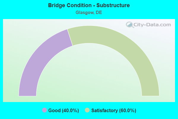
- Bridge Condition - Substructure
- 40.0%Good
- 60.0%Satisfactory
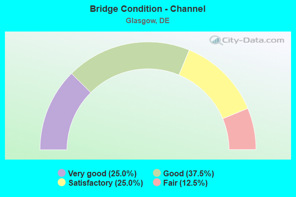
- Bridge Condition - Channel
- 25.0%Very good
- 37.5%Good
- 25.0%Satisfactory
- 12.5%Fair
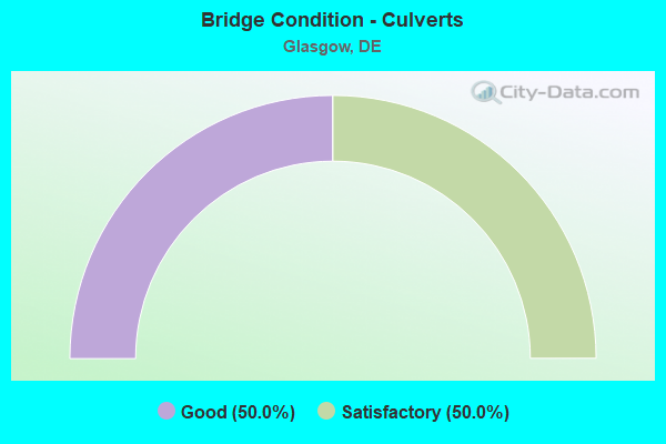
- Bridge Condition - Culverts
- 50.0%Good
- 50.0%Satisfactory
Find on map >> Show street view
Structure Number: 1321B, Location: E OF LUMS POND STATE PARK (Lat: 39.571872, Lng: -75.692928), Route carried "on" structure: City street , Year Built: 1998, Status: Open, Structure Length: 0.79m (2.59ft), Average Daily Traffic: 99 (year 2019), Truck Traffic: 8%, Average Future Daily Traffic: 123 (year 2042), Design Load: HS 25 or greater, Features Intersected: WATERWAY, Facility Carried by Structure: CORNWELL DR.
Minimum Vertical Clearance: 30.48m (100.00ft), Kilometerpoint: 0.080, Lanes on structure: 2, Owner: State Highway Agency, Approaching Roadway Width: 9.4m (30.8ft), Material/Design: Concrete, Design/Construction: Culvert, Number Of Spans In Main Unit: 3, Length of Maximum Span: 2.4m (7.9ft)
Condition: Channel: Fair, Culverts: Satisfactory, Inventory Rating: 91.3 metric tons, Method Used To Determine Inventory Rating: Load Factor (LF), Structural Evaluation: Equal to present minimum criteria, Waterway Adequacy: Equal to present minimum criteria, Approach Roadway Alignment: Equal to present desirable criteria, Designated Inspection Frequency: Every 24 months, Underwater Inspection Frequency: Every 48 months, Inspection Date: June 2020, Underwater Inspection Date: June 2020
Find on map >> Show street view
Structure Number: 1351 387A, Location: NORTH OF GLASGOW (Lat: 39.610300, Lng: -75.746214), Route carried "on" structure: County highway 387A, Year Built: 1926, Year Reconstructed: 1998, Status: Open, Structure Length: 0.98m (3.22ft), Average Daily Traffic: 9,158 (year 2020), Truck Traffic: 8%, Average Future Daily Traffic: 11,382 (year 2043), Design Load: HS 25 or greater, Features Intersected: MUDDY RUN, Facility Carried by Structure: GLASGOW AVE.
Minimum Vertical Clearance: 30.48m (100.00ft), Kilometerpoint: 2.704, Lanes on structure: 1, Owner: State Highway Agency, Approaching Roadway Width: 4.6m (15.1ft), Design/Construction: Slab, Number Of Spans In Main Unit: 1, Length of Maximum Span: 9.4m (30.8ft), Curb-To-Curb Width: 8.0m (26.2ft), Out-to-Out Width: 8.7m (28.5ft)
Condition: Deck: Good, Superstructure: Good, Substructure: Good, Channel: Satisfactory, Operating Rating: 54.4 metric tons, Method Used To Determine Operating Rating: Field evaluation and documented engineering judgment, Inventory Rating: 32.7 metric tons, Method Used To Determine Inventory Rating: Field evaluation and documented engineering judgment, Structural Evaluation: Better than present minimum criteria, Deck Geometry: High priority of replacement, Waterway Adequacy: Better than present minimum criteria, Approach Roadway Alignment: Equal to present desirable criteria, Length Of Structure Improvement: 0.98m (3.22ft), Designated Inspection Frequency: Every 24 months, Inspection Date: April 2021, Bridge Improvement Cost: $25,000, Roadway Improvement Cost: $3,000, Total Project Cost: $38,000, Deck Structure Type: Other, Wearing Surface/Protective System: Wearing Surface: Latex Concrete
Find on map >> Show street view
Structure Number: 1354N387, Location: NORTH OF GLASGOW (Lat: 39.610322, Lng: -75.745019), Route carried "on" structure: State highway 896, Year Built: 1991, Status: Open, Structure Length: 1.30m (4.27ft), Average Daily Traffic: 16,773 (year 2019), Truck Traffic: 9%, Average Future Daily Traffic: 21,045 (year 2043), Design Load: HS 20+Mod, Features Intersected: MUDDY RUN
Minimum Vertical Clearance: 30.48m (100.00ft), Kilometerpoint: 6.100, Lanes on structure: 2, Base Highway Network: Yes, Owner: State Highway Agency, Approaching Roadway Width: 12.2m (40.0ft), Skew: 1 degrees, Material/Design: Concrete, Design/Construction: Culvert, Number Of Spans In Main Unit: 1, Length of Maximum Span: 13.0m (42.7ft), Curb-To-Curb Width: 14.1m (46.3ft), Out-to-Out Width: 14.8m (48.6ft)
Condition: Channel: Good, Culverts: Good, Inventory Rating: 69.9 metric tons, Method Used To Determine Inventory Rating: Load Factor (LF), Structural Evaluation: Better than present minimum criteria, Deck Geometry: Superior to present desirable criteria, Waterway Adequacy: Equal to present minimum criteria, Approach Roadway Alignment: Equal to present desirable criteria, Designated Inspection Frequency: Every 24 months, Inspection Date: March 2021, Deck Structure Type: Concrete Cast-file-Place, Wearing Surface/Protective System: Wearing Surface: Monolithic Concrete, Deck Protection: Epoxy Coated Reinforcing
Find on map >> Show street view
Structure Number: 1354S387, Location: NORTH OF GLASGOW (Lat: 39.610306, Lng: -75.745275), Route carried "on" structure: State highway 896, Year Built: 1991, Status: Open, Structure Length: 1.31m (4.30ft), Average Daily Traffic: 16,773 (year 2019), Truck Traffic: 9%, Average Future Daily Traffic: 21,045 (year 2043), Design Load: HS 20+Mod, Features Intersected: MUDDY RUN
Minimum Vertical Clearance: 30.48m (100.00ft), Kilometerpoint: 6.389, Lanes on structure: 2, Base Highway Network: Yes, Owner: State Highway Agency, Approaching Roadway Width: 12.2m (40.0ft), Skew: 1 degrees, Material/Design: Concrete, Design/Construction: Culvert, Number Of Spans In Main Unit: 1, Length of Maximum Span: 13.1m (43.0ft), Curb-To-Curb Width: 15.5m (50.9ft), Out-to-Out Width: 16.3m (53.5ft)
Condition: Channel: Good, Culverts: Satisfactory, Inventory Rating: 71.5 metric tons, Method Used To Determine Inventory Rating: Load Factor (LF), Structural Evaluation: Equal to present minimum criteria, Deck Geometry: Superior to present desirable criteria, Waterway Adequacy: Equal to present desirable criteria, Approach Roadway Alignment: Equal to present desirable criteria, Designated Inspection Frequency: Every 24 months, Inspection Date: March 2021, Deck Structure Type: Concrete Cast-file-Place, Wearing Surface/Protective System: Wearing Surface: Monolithic Concrete, Deck Protection: Epoxy Coated Reinforcing
Find on map >> Show street view
Structure Number: 1361 356, Location: SOUTH OF NEWARK (Lat: 39.626100, Lng: -75.724258), Route carried "on" structure: State highway 72, Year Built: 1958, Year Reconstructed: 2007, Status: Open, Structure Length: 1.31m (4.30ft), Average Daily Traffic: 14,669 (year 2020), Truck Traffic: 7%, Average Future Daily Traffic: 18,232 (year 2043), Design Load: HS 20+Mod, Features Intersected: MUDDY RUN, Facility Carried by Structure: SUNSET LAKE RD
Minimum Vertical Clearance: 30.48m (100.00ft), Kilometerpoint: 8.400, Lanes on structure: 2, Owner: State Highway Agency, Approaching Roadway Width: 12.2m (40.0ft), Skew: 1 degrees, Material/Design: Prestressed concrete, Design/Construction: Box Beam or Girders - Multiple, Number Of Spans In Main Unit: 1, Length of Maximum Span: 12.1m (39.7ft), Curb-To-Curb Width: 13.4m (44.0ft), Out-to-Out Width: 15.7m (51.5ft)
Condition: Deck: Good, Superstructure: Good, Substructure: Satisfactory, Channel: Satisfactory, Operating Rating: 50.5 metric tons, Method Used To Determine Operating Rating: Load and Resistance Factor Rating (LRFR) rating reported by rating factor(RF) method using HL-93 loadings, Inventory Rating: 34.3 metric tons, Method Used To Determine Inventory Rating: Load and Resistance Factor Rating (LRFR) rating reported by rating factor(RF) method using HL-93 loadings, Structural Evaluation: Equal to present minimum criteria, Deck Geometry: Equal to present minimum criteria, Waterway Adequacy: Equal to present minimum criteria, Approach Roadway Alignment: Equal to present desirable criteria, Designated Inspection Frequency: Every 24 months, Inspection Date: April 2021, Deck Structure Type: Concrete Precast Panels, Wearing Surface/Protective System: Wearing Surface: Bituminous, Membrane: Other
Find on map >> Show street view
Structure Number: 1366 399, Location: N.W. OF SUMMIT BRIDGE (Lat: 39.545125, Lng: -75.759667), Route carried "on" structure: County highway 399, Year Built: 2013, Status: Open, Structure Length: 1.13m (3.71ft), Average Daily Traffic: 2,146 (year 2020), Truck Traffic: 7%, Average Future Daily Traffic: 2,667 (year 2043), Design Load: HL 93, Features Intersected: GUTHRIE RUN, Facility Carried by Structure: CHESPEAKE CITY RD.
Minimum Vertical Clearance: 30.48m (100.00ft), Kilometerpoint: 1.802, Lanes on structure: 2, Owner: State Highway Agency, Approaching Roadway Width: 6.6m (21.7ft), Material/Design: Prestressed concrete, Design/Construction: Box Beam or Girders - Multiple, Number Of Spans In Main Unit: 1, Length of Maximum Span: 9.2m (30.2ft), Curb-To-Curb Width: 12.2m (40.0ft), Out-to-Out Width: 12.2m (40.0ft)
Condition: Deck: Good, Superstructure: Good, Substructure: Good, Channel: Very good, Operating Rating: 39.9 metric tons, Method Used To Determine Operating Rating: Load and Resistance Factor Rating (LRFR) rating reported by rating factor(RF) method using HL-93 loadings, Inventory Rating: 32.4 metric tons, Method Used To Determine Inventory Rating: Load and Resistance Factor Rating (LRFR) rating reported by rating factor(RF) method using HL-93 loadings, Structural Evaluation: Better than present minimum criteria, Deck Geometry: Equal to present minimum criteria, Waterway Adequacy: Equal to present minimum criteria, Approach Roadway Alignment: Equal to present desirable criteria, Length Of Structure Improvement: 1.55m (5.09ft), Designated Inspection Frequency: Every 24 months, Inspection Date: September 2021, Bridge Improvement Cost: $300,000, Roadway Improvement Cost: $30,000, Total Project Cost: $450,000, Deck Structure Type: Concrete Precast Panels, Wearing Surface/Protective System: Wearing Surface: Bituminous
Find on map >> Show street view
Structure Number: 1367, Location: CARAVEL FARMS (Lat: 39.596556, Lng: -75.723778), Route carried "on" structure: City street , Year Built: 1980, Status: Open, Structure Length: 0.69m (2.26ft), Average Daily Traffic: 99 (year 2019), Truck Traffic: 11%, Average Future Daily Traffic: 123 (year 2040), Design Load: HS 20, Features Intersected: BELLTOWN RUN, Facility Carried by Structure: CARAVEL DR
Minimum Vertical Clearance: 30.48m (100.00ft), Kilometerpoint: 0.000, Lanes on structure: 2, Owner: State Highway Agency, Approaching Roadway Width: 6.9m (22.6ft), Material/Design: Concrete, Design/Construction: Culvert, Number Of Spans In Main Unit: 2, Length of Maximum Span: 3.0m (9.8ft), Curb-To-Curb Width: 11.0m (36.1ft), Out-to-Out Width: 11.6m (38.1ft)
Condition: Channel: Good, Culverts: Good, Operating Rating: 54.4 metric tons, Method Used To Determine Operating Rating: Field evaluation and documented engineering judgment, Inventory Rating: 32.7 metric tons, Method Used To Determine Inventory Rating: Field evaluation and documented engineering judgment, Structural Evaluation: Better than present minimum criteria, Deck Geometry: Superior to present desirable criteria, Waterway Adequacy: Better than present minimum criteria, Approach Roadway Alignment: Equal to present desirable criteria, Designated Inspection Frequency: Every 24 months, Inspection Date: October 2020, Wearing Surface/Protective System: Wearing Surface: Bituminous
Find on map >> Show street view
Structure Number: 1506 399, Location: JUST N. OF SUMMIT BRIDGE (Lat: 39.548583, Lng: -75.738789), Route carried "on" structure: County highway 399, Year Built: 1959, Status: Open, Structure Length: 4.55m (14.93ft), Average Daily Traffic: 2,699 (year 2019), Truck Traffic: 8%, Average Future Daily Traffic: 3,354 (year 2042), Design Load: HS 20, Features Intersected: US301/SR896, Facility Carried by Structure: CHESAPEAKE CITY RD
Minimum Vertical Clearance: 30.48m (100.00ft), Kilometerpoint: 3.653, Lanes on structure: 2, Lanes under structure: 4, Owner: State Highway Agency, Approaching Roadway Width: 8.5m (27.9ft), Material/Design: Steel, Design/Construction: Stringer/Multi-beam, Number Of Spans In Main Unit: 3, Length of Maximum Span: 25.0m (82.0ft), Curb-To-Curb Width: 8.5m (27.9ft), Out-to-Out Width: 10.7m (35.1ft)
Condition: Deck: Fair, Superstructure: Satisfactory, Substructure: Satisfactory, Operating Rating: 77.1 metric tons, Method Used To Determine Operating Rating: Load Factor (LF), Inventory Rating: 42.5 metric tons, Method Used To Determine Inventory Rating: Load Factor (LF), Structural Evaluation: Equal to present minimum criteria, Deck Geometry: Meets minimum limits, Underclear: Meets minimum limits, Approach Roadway Alignment: Equal to present desirable criteria, Length Of Structure Improvement: 4.51m (14.80ft), Designated Inspection Frequency: Every 24 months, Inspection Date: August 2020, Bridge Improvement Cost: $521,000, Roadway Improvement Cost: $52,000, Total Project Cost: $781,000, Deck Structure Type: Concrete Cast-file-Place, Wearing Surface/Protective System: Wearing Surface: Monolithic Concrete, Deck Protection: Epoxy Coated Reinforcing
Find on map >> Show street view
Structure Number: 1494016, Location: 9 MI W OF REEDY POINT (Lat: 39.540833, Lng: -75.738333), Route carried "on" structure: State highway 896, Year Built: 1959, Year Reconstructed: 1987, Status: Open, Structure Length: 62.73m (205.81ft), Average Daily Traffic: 26,840 (year 2020), Truck Traffic: 25%, Average Future Daily Traffic: 61,724 (year 2037), Design Load: HS 20, Features Intersected: C&D CANAL
Minimum Vertical Clearance: 4.87m (15.98ft), Kilometerpoint: 18.506, Lanes on structure: 4, Base Highway Network: Yes, Owner: Corps of Engineers (Civil), Approaching Roadway Width: 19.5m (64.0ft), Skew: 30 degrees, Navigation Control: Yes ( Vertical Clearance: 40.8m (133.9ft), Horizontal Clearance: 137.1m (449.8ft)), Material/Design: Steel, Design/Construction: Truss - Thru, Number Of Spans In Main Unit: 3, Number Of Approach Spans: 6, Length of Maximum Span: 182.9m (600.1ft), Curb-To-Curb Width: 17.8m (58.4ft), Out-to-Out Width: 19.5m (64.0ft)
Condition: Deck: Satisfactory, Superstructure: Fair, Substructure: Satisfactory, Channel: Very good, Operating Rating: 27.5 metric tons, Method Used To Determine Operating Rating: Load and Resistance Factor Rating (LRFR) rating reported by rating factor(RF) method using HL-93 loadings, Inventory Rating: 21.1 metric tons, Method Used To Determine Inventory Rating: Load and Resistance Factor Rating (LRFR) rating reported by rating factor(RF) method using HL-93 loadings, Structural Evaluation: Somewhat better than minimum adequacy, Deck Geometry: Somewhat better than minimum adequacy, Waterway Adequacy: Superior to present desirable criteria, Approach Roadway Alignment: Better than present minimum criteria, Length Of Structure Improvement: 62.73m (205.81ft), Designated Inspection Frequency: Every 24 months, Critical Feature Inspection Frequency: Every 24 months, Underwater Inspection Frequency: Every 48 months, Inspection Date: June 2020, Critical Feature Inspection Date: June 2020, Underwater Inspection Date: June 2020, Bridge Improvement Cost: $500,000, Roadway Improvement Cost: $10,000, Total Project Cost: $510,000 ( Estimate for 2018), Deck Structure Type: Concrete Cast-file-Place, Wearing Surface/Protective System: Wearing Surface: Monolithic Concrete
Find on map >> Show street view
Structure Number: 1506 399, Location: JUST N. OF SUMMIT BRIDGE (Lat: 39.548583, Lng: -75.738789), Route carried "under" structure: US 301, Year Built: 1959, Structure Length: 0. m, Average Daily Traffic: 30,378 (year 2019), Truck Traffic: 9%, Features Intersected: US301/SR896, Facility Carried by Structure: CHESAPEAKE CITY RD
Minimum Vertical Clearance: 4.51m (14.80ft), Kilometerpoint: 5.520, Lanes on structure: 2, Lanes under structure: 4, Material/Design: Steel, Design/Construction: Stringer/Multi-beam, Length of Maximum Span: 25.0m (82.0ft)