Bridge Statistics for Gladstone, Michigan (MI)
Condition, Traffic, Stress, Structural Evaluation, Project Costs
- National Bridge Inventory (NBI) Statistics
- 13Number of bridges
- 108ft / 33.0mTotal length
- $200,000Total costs
- 42,127Total average daily traffic
- 3,449Total average daily truck traffic
- National Bridge Inventory (NBI) Registered Bridges for Gladstone
- No street view available for this location
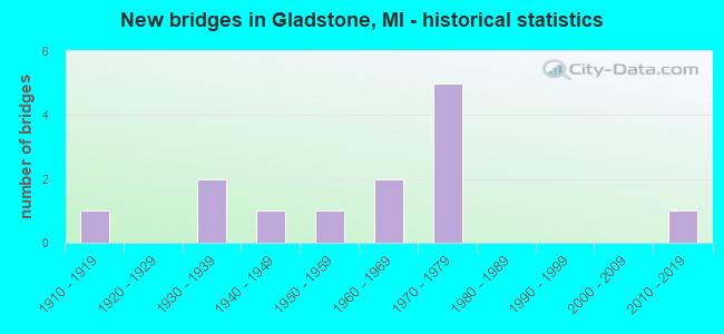
- New bridges - historical statistics
- 11910-1919
- 21930-1939
- 11940-1949
- 11950-1959
- 21960-1969
- 51970-1979
- 12010-2019

- Reconstructed bridges - Historical Statistics
- 21990-1999
- 22000-2009
- 12010-2019


- Bridge Condition - Deck
- 22.2%Very good
- 33.3%Good
- 33.3%Satisfactory
- 11.1%Fair

- Bridge Condition - Superstructure
- 10.0%Excellent
- 70.0%Good
- 10.0%Fair
- 10.0%Poor

- Bridge Condition - Substructure
- 60.0%Good
- 20.0%Satisfactory
- 10.0%Fair
- 10.0%Poor

- Bridge Condition - Channel
- 10.0%Very good
- 50.0%Good
- 30.0%Satisfactory
- 10.0%Fair

- Bridge Condition - Culverts
- 50.0%Very good
- 50.0%Satisfactory
Find on map >> Show street view
Structure Number: 209, Location: 0.4 MI E OF US-41 (Lat: 45.926561, Lng: -86.963425), Route carried "on" structure: US 2, Year Built: 1931, Year Reconstructed: 1997, Status: Open, Structure Length: 2.43m (7.97ft), Average Daily Traffic: 8,505 (year 2007), Truck Traffic: 8%, Average Future Daily Traffic: 11,941 (year 2018), Design Load: HS 25 or greater, Features Intersected: RAPID RIVER
Minimum Vertical Clearance: 30.48m (100.00ft), Kilometerpoint: 52.774, Lanes on structure: 2, Base Highway Network: Yes (Inventory Route: 134, Subroute: 6), Owner: State Highway Agency, Approaching Roadway Width: 14.6m (47.9ft), Skew: 2 degrees, Material/Design: Steel, Design/Construction: Stringer/Multi-beam, Number Of Spans In Main Unit: 2, Length of Maximum Span: 11.9m (39.0ft), Curb or Sidewalk Widths: Left: 1.5m (4.9ft), Right: 1.5m (4.9ft), Curb-To-Curb Width: 15.9m (52.2ft), Out-to-Out Width: 19.7m (64.6ft)
Condition: Deck: Satisfactory, Superstructure: Good, Substructure: Good, Channel: Good, Operating Rating: 72.3 metric tons, Method Used To Determine Operating Rating: Load Factor (LF) rating reported by rating factor (RF) method using MS18 loading, Inventory Rating: 43.1 metric tons, Method Used To Determine Inventory Rating: Load Factor (LF) rating reported by rating factor (RF) method using MS18 loading, Structural Evaluation: Better than present minimum criteria, Deck Geometry: Superior to present desirable criteria, Waterway Adequacy: Equal to present desirable criteria, Approach Roadway Alignment: Equal to present desirable criteria, Designated Inspection Frequency: Every 24 months, Inspection Date: September 2021, Deck Structure Type: Concrete Cast-file-Place, Wearing Surface/Protective System: Wearing Surface: Monolithic Concrete, Deck Protection: Epoxy Coated Reinforcing
Find on map >> Show street view
Structure Number: 21, Location: 3.5 MI N OF M-35 (Lat: 45.895744, Lng: -86.998322), Route carried "on" structure: US 2, Year Built: 1971, Year Reconstructed: 2006, Status: Open, Structure Length: 2.23m (7.32ft), Average Daily Traffic: 4,267 (year 2007), Truck Traffic: 11%, Average Future Daily Traffic: 11,500 (year 2026), Design Load: HS 20, Features Intersected: DAYS RIVER
Minimum Vertical Clearance: 30.48m (100.00ft), Kilometerpoint: 9.862, Lanes on structure: 2, Base Highway Network: Yes (Inventory Route: 321, Subroute: 1), Owner: State Highway Agency, Approaching Roadway Width: 12.8m (42.0ft), Skew: 3 degrees, Material/Design: Steel, Design/Construction: Stringer/Multi-beam, Number Of Spans In Main Unit: 1, Length of Maximum Span: 21.3m (69.9ft), Curb-To-Curb Width: 11.7m (38.4ft), Out-to-Out Width: 12.9m (42.3ft)
Condition: Deck: Good, Superstructure: Good, Substructure: Good, Channel: Satisfactory, Operating Rating: 65.1 metric tons, Method Used To Determine Operating Rating: Load Factor (LF) rating reported by rating factor (RF) method using MS18 loading, Inventory Rating: 39.2 metric tons, Method Used To Determine Inventory Rating: Load Factor (LF) rating reported by rating factor (RF) method using MS18 loading, Structural Evaluation: Better than present minimum criteria, Deck Geometry: Better than present minimum criteria, Waterway Adequacy: Equal to present desirable criteria, Approach Roadway Alignment: Equal to present desirable criteria, Designated Inspection Frequency: Every 24 months, Inspection Date: September 2021, Deck Structure Type: Concrete Cast-file-Place, Wearing Surface/Protective System: Wearing Surface: Latex Concrete
Find on map >> Show street view
Structure Number: 2101, Location: 3.5 MI N OF M-35 (Lat: 45.895697, Lng: -86.997903), Route carried "on" structure: US 2, Year Built: 1971, Year Reconstructed: 2006, Status: Open, Structure Length: 2.23m (7.32ft), Average Daily Traffic: 4,267 (year 2007), Truck Traffic: 10%, Average Future Daily Traffic: 6,098 (year 2018), Design Load: HS 20, Features Intersected: DAYS RIVER
Minimum Vertical Clearance: 30.48m (100.00ft), Kilometerpoint: 47.439, Lanes on structure: 2, Base Highway Network: Yes (Inventory Route: 134, Subroute: 6), Owner: State Highway Agency, Approaching Roadway Width: 12.8m (42.0ft), Skew: 3 degrees, Material/Design: Steel, Design/Construction: Stringer/Multi-beam, Number Of Spans In Main Unit: 1, Length of Maximum Span: 21.3m (69.9ft), Curb-To-Curb Width: 11.7m (38.4ft), Out-to-Out Width: 12.9m (42.3ft)
Condition: Deck: Satisfactory, Superstructure: Good, Substructure: Good, Channel: Good, Operating Rating: 66.7 metric tons, Method Used To Determine Operating Rating: Load Factor (LF) rating reported by rating factor (RF) method using MS18 loading, Inventory Rating: 39.9 metric tons, Method Used To Determine Inventory Rating: Load Factor (LF) rating reported by rating factor (RF) method using MS18 loading, Structural Evaluation: Better than present minimum criteria, Deck Geometry: Better than present minimum criteria, Waterway Adequacy: Equal to present desirable criteria, Approach Roadway Alignment: Equal to present desirable criteria, Designated Inspection Frequency: Every 24 months, Inspection Date: September 2021, Deck Structure Type: Concrete Cast-file-Place, Wearing Surface/Protective System: Wearing Surface: Latex Concrete
Find on map >> Show street view
Structure Number: 2102, Location: E LTS OF GLADSTONE (Lat: 45.859592, Lng: -87.025875), Route carried "on" structure: US 2, Year Built: 1971, Status: Open, Structure Length: 5.76m (18.90ft), Average Daily Traffic: 4,661 (year 2007), Truck Traffic: 10%, Average Future Daily Traffic: 5,510 (year 2018), Design Load: HS 20, Features Intersected: WCL RR
Minimum Vertical Clearance: 30.48m (100.00ft), Kilometerpoint: 5.190, Lanes on structure: 2, Base Highway Network: Yes (Inventory Route: 321, Subroute: 1), Owner: State Highway Agency, Approaching Roadway Width: 12.2m (40.0ft), Skew: 4 degrees, Material/Design: Steel, Design/Construction: Stringer/Multi-beam, Number Of Spans In Main Unit: 3, Length of Maximum Span: 20.4m (66.9ft), Curb or Sidewalk Widths: Left: 0.2m (0.7ft), Right: 0.2m (0.7ft), Curb-To-Curb Width: 12.2m (40.0ft), Out-to-Out Width: 12.9m (42.3ft)
Condition: Deck: Satisfactory, Superstructure: Good, Substructure: Satisfactory, Operating Rating: 61.9 metric tons, Method Used To Determine Operating Rating: Load Factor (LF) rating reported by rating factor (RF) method using MS18 loading, Inventory Rating: 36.9 metric tons, Method Used To Determine Inventory Rating: Load Factor (LF) rating reported by rating factor (RF) method using MS18 loading, Structural Evaluation: Equal to present minimum criteria, Deck Geometry: Better than present minimum criteria, Approach Roadway Alignment: Equal to present desirable criteria, Designated Inspection Frequency: Every 24 months, Inspection Date: September 2021, Deck Structure Type: Concrete Cast-file-Place, Wearing Surface/Protective System: Wearing Surface: Latex Concrete
Find on map >> Show street view
Structure Number: 2103, Location: E LTS OF GLADSTONE (Lat: 45.859914, Lng: -87.025653), Route carried "on" structure: US 2, Year Built: 1970, Status: Open, Structure Length: 5.76m (18.90ft), Average Daily Traffic: 4,661 (year 2007), Truck Traffic: 10%, Average Future Daily Traffic: 5,510 (year 2018), Design Load: HS 20, Features Intersected: WCL RR
Minimum Vertical Clearance: 30.48m (100.00ft), Kilometerpoint: 42.808, Lanes on structure: 2, Base Highway Network: Yes (Inventory Route: 134, Subroute: 6), Owner: State Highway Agency, Approaching Roadway Width: 12.2m (40.0ft), Skew: 4 degrees, Material/Design: Steel, Design/Construction: Stringer/Multi-beam, Number Of Spans In Main Unit: 3, Length of Maximum Span: 20.4m (66.9ft), Curb or Sidewalk Widths: Left: 0.2m (0.7ft), Right: 0.2m (0.7ft), Curb-To-Curb Width: 12.2m (40.0ft), Out-to-Out Width: 12.9m (42.3ft)
Condition: Deck: Good, Superstructure: Good, Substructure: Good, Operating Rating: 61.9 metric tons, Method Used To Determine Operating Rating: Load Factor (LF) rating reported by rating factor (RF) method using MS18 loading, Inventory Rating: 36.9 metric tons, Method Used To Determine Inventory Rating: Load Factor (LF) rating reported by rating factor (RF) method using MS18 loading, Structural Evaluation: Better than present minimum criteria, Deck Geometry: Better than present minimum criteria, Approach Roadway Alignment: Equal to present desirable criteria, Designated Inspection Frequency: Every 24 months, Inspection Date: September 2021, Deck Structure Type: Concrete Cast-file-Place, Wearing Surface/Protective System: Wearing Surface: Latex Concrete
Find on map >> Show street view
Structure Number: 2109, Location: IN BRAMPTON (Lat: 45.930067, Lng: -87.070453), Route carried "on" structure: State highway 35, Year Built: 1966, Status: Open, Structure Length: 1.82m (5.97ft), Average Daily Traffic: 3,875 (year 2007), Truck Traffic: 11%, Average Future Daily Traffic: 4,265 (year 2018), Design Load: HS 20, Features Intersected: DAYS RIVER
Minimum Vertical Clearance: 30.48m (100.00ft), Kilometerpoint: 11.329, Lanes on structure: 2, Base Highway Network: Yes (Inventory Route: 550, Subroute: 4), Owner: State Highway Agency, Approaching Roadway Width: 12.2m (40.0ft), Skew: 4 degrees, Material/Design: Steel, Design/Construction: Stringer/Multi-beam, Number Of Spans In Main Unit: 1, Length of Maximum Span: 18.2m (59.7ft), Curb or Sidewalk Widths: Left: 0.2m (0.7ft), Right: 0.2m (0.7ft), Curb-To-Curb Width: 13.4m (44.0ft), Out-to-Out Width: 14.1m (46.3ft)
Condition: Deck: Good, Superstructure: Good, Substructure: Good, Channel: Good, Operating Rating: 63.2 metric tons, Method Used To Determine Operating Rating: Load Factor (LF) rating reported by rating factor (RF) method using MS18 loading, Inventory Rating: 37.9 metric tons, Method Used To Determine Inventory Rating: Load Factor (LF) rating reported by rating factor (RF) method using MS18 loading, Structural Evaluation: Better than present minimum criteria, Deck Geometry: Better than present minimum criteria, Waterway Adequacy: Equal to present minimum criteria, Approach Roadway Alignment: Equal to present desirable criteria, Designated Inspection Frequency: Every 24 months, Inspection Date: October 2021, Deck Structure Type: Concrete Cast-file-Place, Wearing Surface/Protective System: Wearing Surface: Latex Concrete
Find on map >> Show street view
Structure Number: 2119, Location: 1.5 MI SW OF BRAMPTON (Lat: 45.917911, Lng: -87.088353), Route carried "on" structure: County highway , Year Built: 1959, Year Reconstructed: 2004, Status: Open, Structure Length: 1.03m (3.38ft), Average Daily Traffic: 148 (year 2021), Truck Traffic: 18%, Average Future Daily Traffic: 163 (year 2041), Design Load: H 15, Features Intersected: DAY S RIVER, Facility Carried by Structure: ROUTE 434
Minimum Vertical Clearance: 30.48m (100.00ft), Kilometerpoint: 3.993, Lanes on structure: 2, Owner: County Highway Agency, Approaching Roadway Width: 9.1m (29.9ft), Material/Design: Prestressed concrete, Design/Construction: Tee Beam, Number Of Spans In Main Unit: 1, Length of Maximum Span: 10.0m (32.8ft), Curb-To-Curb Width: 9.1m (29.9ft), Out-to-Out Width: 10.0m (32.8ft)
Condition: Deck: Very good, Superstructure: Good, Substructure: Good, Channel: Good, Operating Rating: 48.9 metric tons, Method Used To Determine Operating Rating: Field evaluation and documented engineering judgment, Inventory Rating: 29.3 metric tons, Method Used To Determine Inventory Rating: Field evaluation and documented engineering judgment, Structural Evaluation: Better than present minimum criteria, Deck Geometry: Equal to present minimum criteria, Waterway Adequacy: Equal to present desirable criteria, Approach Roadway Alignment: Equal to present minimum criteria, Designated Inspection Frequency: Every 24 months, Inspection Date: June 2021, Deck Structure Type: Concrete Precast Panels, Wearing Surface/Protective System: Wearing Surface: Bituminous
Find on map >> Show street view
Structure Number: 212, Location: 2 MI WEST OF GLADSTONE (Lat: 45.840583, Lng: -87.088697), Route carried "on" structure: County highway 2122, Year Built: 1974, Year Reconstructed: 2015, Status: Open, Structure Length: 7.45m (24.44ft), Average Daily Traffic: 1,539 (year 2020), Truck Traffic: 5%, Average Future Daily Traffic: 1,600 (year 2040), Design Load: Greater than HL93, Features Intersected: ESCANABA RIVER, Facility Carried by Structure: ROUTE 420
Minimum Vertical Clearance: 30.48m (100.00ft), Kilometerpoint: 11.082, Lanes on structure: 2, Owner: County Highway Agency, Approaching Roadway Width: 10.3m (33.8ft), Material/Design: Steel continuous, Design/Construction: Stringer/Multi-beam, Number Of Spans In Main Unit: 2, Length of Maximum Span: 36.6m (120.1ft), Curb-To-Curb Width: 10.4m (34.1ft), Out-to-Out Width: 11.3m (37.1ft)
Condition: Deck: Very good, Superstructure: Excellent, Substructure: Satisfactory, Channel: Good, Operating Rating: 65.4 metric tons, Method Used To Determine Operating Rating: Load and Resistance Factor Rating (LRFR) rating reported by rating factor(RF) method using HL-93 loadings, Inventory Rating: 50.5 metric tons, Method Used To Determine Inventory Rating: Load and Resistance Factor Rating (LRFR) rating reported by rating factor(RF) method using HL-93 loadings, Structural Evaluation: Equal to present minimum criteria, Deck Geometry: Equal to present minimum criteria, Waterway Adequacy: Equal to present desirable criteria, Approach Roadway Alignment: Equal to present desirable criteria, Designated Inspection Frequency: Every 24 months, Underwater Inspection Frequency: Every 60 months, Inspection Date: July 2020, Underwater Inspection Date: August 2019, Deck Structure Type: Concrete Cast-file-Place, Wearing Surface/Protective System: Wearing Surface: Monolithic Concrete, Deck Protection: Epoxy Coated Reinforcing
Find on map >> Show street view
Structure Number: 2141, Location: 2 MI N OF GLADSTONE (Lat: 45.894944, Lng: -86.992814), Route carried "on" structure: County highway , Year Built: 1940, Status: Open, Structure Length: 1.46m (4.79ft), Average Daily Traffic: 783 (year 2021), Truck Traffic: 8%, Average Future Daily Traffic: 861 (year 2041), Design Load: H 20, Features Intersected: DAY S RIVER, Facility Carried by Structure: ROUTE 515
Minimum Vertical Clearance: 30.48m (100.00ft), Kilometerpoint: 4.938, Lanes on structure: 2, Owner: County Highway Agency, Approaching Roadway Width: 11.6m (38.1ft), Material/Design: Concrete, Design/Construction: Slab, Number Of Spans In Main Unit: 2, Length of Maximum Span: 7.0m (23.0ft), Curb-To-Curb Width: 10.7m (35.1ft), Out-to-Out Width: 12.3m (40.4ft)
Condition: Deck: Fair, Superstructure: Fair, Substructure: Fair, Channel: Fair, Operating Rating: 43.7 metric tons, Method Used To Determine Operating Rating: Field evaluation and documented engineering judgment, Inventory Rating: 26.2 metric tons, Method Used To Determine Inventory Rating: Field evaluation and documented engineering judgment, Structural Evaluation: Somewhat better than minimum adequacy, Deck Geometry: Equal to present minimum criteria, Waterway Adequacy: Equal to present desirable criteria, Approach Roadway Alignment: Equal to present desirable criteria, Designated Inspection Frequency: Every 24 months, Inspection Date: June 2021, Deck Structure Type: Concrete Cast-file-Place, Wearing Surface/Protective System: Wearing Surface: Bituminous
Find on map >> Show street view
Structure Number: 3301, Location: 0.2 MILE E OF SQUIRES RD (Lat: 42.014775, Lng: -84.822103), Route carried "on" structure: County highway , Year Built: 1965, Status: Open, Structure Length: 0.70m (2.30ft), Average Daily Traffic: 418 (year 2013), Average Future Daily Traffic: 686 (year 2038), Design Load: HS 20+Mod, Features Intersected: SOAP CREEK, Facility Carried by Structure: STERLING ROAD
Minimum Vertical Clearance: 30.48m (100.00ft), Kilometerpoint: 0.338, Lanes on structure: 2, Owner: County Highway Agency, Approaching Roadway Width: 10.4m (34.1ft), Skew: 2 degrees, Material/Design: Steel, Design/Construction: Culvert, Number Of Spans In Main Unit: 2, Length of Maximum Span: 3.0m (9.8ft), Curb-To-Curb Width: 9.4m (30.8ft), Out-to-Out Width: 9.4m (30.8ft)
Condition: Channel: Satisfactory, Culverts: Satisfactory, Operating Rating: 97.2 metric tons, Method Used To Determine Operating Rating: Load Factor (LF) rating reported by rating factor (RF) method using MS18 loading, Inventory Rating: 97.2 metric tons, Method Used To Determine Inventory Rating: Load Factor (LF) rating reported by rating factor (RF) method using MS18 loading, Structural Evaluation: Equal to present minimum criteria, Deck Geometry: Equal to present minimum criteria, Waterway Adequacy: Meets minimum limits, Approach Roadway Alignment: Better than present minimum criteria, Designated Inspection Frequency: Every 24 months, Inspection Date: November 2020, Wearing Surface/Protective System: Wearing Surface: Bituminous
Find on map >> Show street view
Structure Number: 3351, Location: 0.05 MI W OF CRAMPTON (Lat: 41.769686, Lng: -84.573306), Route carried "on" structure: Alternate County highway , Year Built: 1918, Status: Open, Structure Length: 1.09m (3.58ft), Average Daily Traffic: 32 (year 2014), Average Future Daily Traffic: 52 (year 2038), Design Load: HS 20+Mod, Features Intersected: SILVER CREEK, Facility Carried by Structure: BURT ROAD
Minimum Vertical Clearance: 30.48m (100.00ft), Kilometerpoint: 2.065, Lanes on structure: 2, Owner: County Highway Agency, Approaching Roadway Width: 5.8m (19.0ft), Material/Design: Concrete, Design/Construction: Arch - Deck, Number Of Spans In Main Unit: 1, Length of Maximum Span: 9.4m (30.8ft), Curb-To-Curb Width: 6.1m (20.0ft), Out-to-Out Width: 6.7m (22.0ft)
Condition: Superstructure: Poor, Substructure: Poor, Channel: Satisfactory, Operating Rating: 54.6 metric tons, Method Used To Determine Operating Rating: Field evaluation and documented engineering judgment, Inventory Rating: 32.7 metric tons, Method Used To Determine Inventory Rating: Field evaluation and documented engineering judgment, Structural Evaluation: Meets minimum limits, Deck Geometry: Somewhat better than minimum adequacy, Waterway Adequacy: Equal to present desirable criteria, Approach Roadway Alignment: Somewhat better than minimum adequacy, Length Of Structure Improvement: 1.52m (4.99ft), Designated Inspection Frequency: Every 12 months, Inspection Date: November 2021, Bridge Improvement Cost: $95,000, Roadway Improvement Cost: $60,000, Total Project Cost: $200,000
Find on map >> Show street view
Structure Number: 13567, Location: 9.1 MI S JCT US-2 (Lat: 45.789469, Lng: -86.976269), Route carried "on" structure: County highway 513, Year Built: 2010, Status: Open, Structure Length: 1.04m (3.41ft), Average Daily Traffic: 150 (year 2001), Average Future Daily Traffic: 173 (year 2021), Features Intersected: SQUAW CREEK
Minimum Vertical Clearance: 30.48m (100.00ft), Kilometerpoint: 14.108, Lanes on structure: 2, Owner: County Highway Agency, Approaching Roadway Width: 9.1m (29.9ft), Material/Design: Concrete, Design/Construction: Culvert, Number Of Spans In Main Unit: 1, Length of Maximum Span: 9.8m (32.2ft), Curb-To-Curb Width: 10.1m (33.1ft), Out-to-Out Width: 13.4m (44.0ft)
Condition: Channel: Very good, Culverts: Very good, Operating Rating: 48.3 metric tons, Method Used To Determine Operating Rating: Load and Resistance Factor (LRFR), Inventory Rating: 38.9 metric tons, Method Used To Determine Inventory Rating: Load and Resistance Factor (LRFR), Structural Evaluation: Equal to present desirable criteria, Deck Geometry: Better than present minimum criteria, Waterway Adequacy: Equal to present desirable criteria, Approach Roadway Alignment: Equal to present desirable criteria, Designated Inspection Frequency: Every 24 months, Inspection Date: July 2020, Deck Structure Type: Concrete Precast Panels, Wearing Surface/Protective System: Wearing Surface: Bituminous
Find on map >> Show street view
Structure Number: 2111, Location: IN GLADSTONE (4TH AVE) (Lat: 45.852678, Lng: -87.025367), Route carried "under" structure: State highway 35, Year Built: 1936, Structure Length: 0. m, Average Daily Traffic: 8,821 (year 2007), Truck Traffic: 4%, Features Intersected: M-35, Facility Carried by Structure: WCL RR
Minimum Vertical Clearance: 4.24m (13.91ft), Kilometerpoint: 0.183, Lanes under structure: 4, Material/Design: Steel, Design/Construction: Girder and Floorbeam System, Length of Maximum Span: 18.6m (61.0ft)