Bridge Statistics for Gibsland, Louisiana (LA)
Condition, Traffic, Stress, Structural Evaluation, Project Costs
- National Bridge Inventory (NBI) Statistics
- 26Number of bridges
- 430ft / 131mTotal length
- $6,475,000Total costs
- 312,300Total average daily traffic
- 66,724Total average daily truck traffic
- National Bridge Inventory (NBI) Registered Bridges for Gibsland
- No street view available for this location
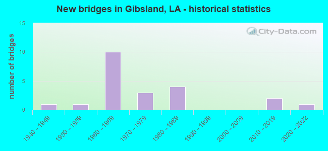
- New bridges - historical statistics
- 11940-1949
- 11950-1959
- 101960-1969
- 31970-1979
- 41980-1989
- 22010-2019
- 12020-2022

- Reconstructed bridges - Historical Statistics
- 11970-1979
- 11980-1989


- Bridge Condition - Deck
- 14.3%Very good
- 33.3%Satisfactory
- 33.3%Fair
- 9.5%Poor
- 4.8%Imminent failure
- 4.8%Failed

- Bridge Condition - Superstructure
- 14.3%Very good
- 19.0%Satisfactory
- 52.4%Fair
- 9.5%Poor
- 4.8%Failed

- Bridge Condition - Substructure
- 14.3%Very good
- 9.5%Good
- 33.3%Satisfactory
- 28.6%Fair
- 4.8%Poor
- 4.8%Critical
- 4.8%Failed

- Bridge Condition - Channel
- 17.6%Very good
- 35.3%Good
- 47.1%Satisfactory
Find on map >> Show street view
Structure Number: 40700000000113, Location: 5.5 MI E OF LA 507 (Lat: 32.276381, Lng: -93.082811), Route carried "on" structure: State highway 4, Year Built: 2021, Status: Open, Structure Length: 3.05m (10.01ft), Average Daily Traffic: 650 (year 2019), Truck Traffic: 14%, Average Future Daily Traffic: 800 (year 2039), Design Load: Greater than HL93, Features Intersected: CREEK
Minimum Vertical Clearance: 30+ m (98+ ft), Kilometerpoint: 8.927, Lanes on structure: 2, Owner: State Highway Agency, Approaching Roadway Width: 7.4m (24.3ft), Material/Design: Concrete, Design/Construction: Slab, Number Of Spans In Main Unit: 5, Length of Maximum Span: 6.1m (20.0ft), Curb-To-Curb Width: 9.5m (31.2ft), Out-to-Out Width: 10.5m (34.4ft)
Condition: Deck: Very good, Superstructure: Very good, Substructure: Very good, Channel: Good, Operating Rating: 50.2 metric tons, Method Used To Determine Operating Rating: Load and Resistance Factor Rating (LRFR) rating reported by rating factor(RF) method using HL-93 loadings, Inventory Rating: 39.5 metric tons, Method Used To Determine Inventory Rating: Load and Resistance Factor Rating (LRFR) rating reported by rating factor(RF) method using HL-93 loadings, Structural Evaluation: Equal to present desirable criteria, Deck Geometry: Equal to present minimum criteria, Waterway Adequacy: Meets minimum limits, Approach Roadway Alignment: Equal to present minimum criteria, Designated Inspection Frequency: Every 24 months, Underwater Inspection Frequency: Every 60 months, Inspection Date: April 2021, Underwater Inspection Date: December 2020, Deck Structure Type: Concrete Cast-file-Place
Find on map >> Show street view
Structure Number: 40700000040307, Location: 1.1 MI EAST OF LA 154 (Lat: 32.546539, Lng: -93.034681), Route carried "on" structure: US 80, Year Built: 2012, Status: Open, Structure Length: 9.14m (29.99ft), Average Daily Traffic: 1,180 (year 2016), Truck Traffic: 19%, Average Future Daily Traffic: 2,108 (year 2036), Design Load: HS 20, Features Intersected: BLACK LAKE CREEK
Minimum Vertical Clearance: 30+ m (98+ ft), Kilometerpoint: 16.454, Lanes on structure: 2, Owner: State Highway Agency, Approaching Roadway Width: 7.3m (24.0ft), Skew: 34 degrees, Material/Design: Concrete, Design/Construction: Slab, Number Of Spans In Main Unit: 15, Length of Maximum Span: 6.1m (20.0ft), Curb-To-Curb Width: 12.0m (39.4ft), Out-to-Out Width: 13.0m (42.7ft)
Condition: Deck: Very good, Superstructure: Very good, Substructure: Very good, Channel: Satisfactory, Operating Rating: 51.2 metric tons, Method Used To Determine Operating Rating: Load and Resistance Factor Rating (LRFR) rating reported by rating factor(RF) method using HL-93 loadings, Inventory Rating: 39.5 metric tons, Method Used To Determine Inventory Rating: Load and Resistance Factor Rating (LRFR) rating reported by rating factor(RF) method using HL-93 loadings, Structural Evaluation: Equal to present desirable criteria, Deck Geometry: Equal to present minimum criteria, Waterway Adequacy: Better than present minimum criteria, Approach Roadway Alignment: Equal to present desirable criteria, Designated Inspection Frequency: Every 24 months, Underwater Inspection Frequency: Every 60 months, Inspection Date: April 2020, Underwater Inspection Date: August 2020, Deck Structure Type: Concrete Cast-file-Place, Wearing Surface/Protective System: Wearing Surface: Monolithic Concrete
Find on map >> Show street view
Structure Number: 40700000301176, Location: 1.94 MI SOUTHEAST OF US 8 (Lat: 32.531519, Lng: -93.016661), Route carried "on" structure: County highway , Year Built: 2013, Status: Open, Structure Length: 1.83m (6.00ft), Average Daily Traffic: 150 (year 2020), Average Future Daily Traffic: 255 (year 2036), Design Load: HS 20, Features Intersected: TRIB TO BLACK LAKE CREEK, Facility Carried by Structure: Grover Jones Rd
Minimum Vertical Clearance: 30+ m (98+ ft), Kilometerpoint: 0.000, Lanes on structure: 2, Owner: County Highway Agency, Approaching Roadway Width: 5.5m (18.0ft), Skew: 30 degrees, Material/Design: Concrete, Design/Construction: Slab, Number Of Spans In Main Unit: 3, Length of Maximum Span: 6.1m (20.0ft), Curb-To-Curb Width: 7.2m (23.6ft), Out-to-Out Width: 8.1m (26.6ft)
Condition: Deck: Very good, Superstructure: Very good, Substructure: Very good, Channel: Very good, Operating Rating: 42.1 metric tons, Method Used To Determine Operating Rating: Load and Resistance Factor Rating (LRFR) rating reported by rating factor(RF) method using HL-93 loadings, Inventory Rating: 32.4 metric tons, Method Used To Determine Inventory Rating: Load and Resistance Factor Rating (LRFR) rating reported by rating factor(RF) method using HL-93 loadings, Structural Evaluation: Equal to present desirable criteria, Deck Geometry: Meets minimum limits, Waterway Adequacy: Equal to present desirable criteria, Approach Roadway Alignment: Equal to present minimum criteria, Designated Inspection Frequency: Every 24 months, Inspection Date: May 2021, Deck Structure Type: Concrete Precast Panels, Wearing Surface/Protective System: Wearing Surface: Monolithic Concrete
Find on map >> Show street view
Structure Number: 40700010605801, Location: 4.0 MI SOUTH OF I-20 (Lat: 32.545931, Lng: -93.108000), Route carried "on" structure: US 80, Year Built: 1984, Status: Open, Structure Length: 15.30m (50.20ft), Average Daily Traffic: 1,320 (year 2016), Truck Traffic: 19%, Average Future Daily Traffic: 2,312 (year 2036), Design Load: HS 20, Features Intersected: LEATHERMAN CREEK
Minimum Vertical Clearance: 30+ m (98+ ft), Kilometerpoint: 9.312, Lanes on structure: 2, Owner: State Highway Agency, Approaching Roadway Width: 12.2m (40.0ft), Material/Design: Concrete, Design/Construction: Slab, Number Of Spans In Main Unit: 25, Length of Maximum Span: 6.1m (20.0ft), Curb-To-Curb Width: 12.3m (40.4ft), Out-to-Out Width: 13.0m (42.7ft)
Condition: Deck: Satisfactory, Superstructure: Satisfactory, Substructure: Satisfactory, Channel: Satisfactory, Operating Rating: 68.0 metric tons, Method Used To Determine Operating Rating: Load Factor (LF), Inventory Rating: 40.8 metric tons, Method Used To Determine Inventory Rating: Load Factor (LF), Structural Evaluation: Equal to present minimum criteria, Deck Geometry: Better than present minimum criteria, Waterway Adequacy: Somewhat better than minimum adequacy, Approach Roadway Alignment: Equal to present desirable criteria, Designated Inspection Frequency: Every 24 months, Underwater Inspection Frequency: Every 60 months, Inspection Date: May 2021, Underwater Inspection Date: August 2020, Deck Structure Type: Concrete Cast-file-Place
Find on map >> Show street view
Structure Number: 40700010606621, Location: 4.8 MI SOUTH OF I-20 (Lat: 32.546169, Lng: -93.094200), Route carried "on" structure: US 80, Year Built: 1984, Status: Open, Structure Length: 7.35m (24.11ft), Average Daily Traffic: 1,320 (year 2016), Truck Traffic: 19%, Average Future Daily Traffic: 2,312 (year 2036), Design Load: HS 20, Features Intersected: BRINSON CREEK
Minimum Vertical Clearance: 30+ m (98+ ft), Kilometerpoint: 10.609, Lanes on structure: 2, Owner: State Highway Agency, Approaching Roadway Width: 12.2m (40.0ft), Material/Design: Concrete, Design/Construction: Slab, Number Of Spans In Main Unit: 12, Length of Maximum Span: 6.1m (20.0ft), Curb-To-Curb Width: 12.3m (40.4ft), Out-to-Out Width: 13.0m (42.7ft)
Condition: Deck: Fair, Superstructure: Fair, Substructure: Satisfactory, Channel: Satisfactory, Operating Rating: 68.0 metric tons, Method Used To Determine Operating Rating: Load Factor (LF), Inventory Rating: 40.8 metric tons, Method Used To Determine Inventory Rating: Load Factor (LF), Structural Evaluation: Somewhat better than minimum adequacy, Deck Geometry: Better than present minimum criteria, Waterway Adequacy: Equal to present minimum criteria, Approach Roadway Alignment: Equal to present desirable criteria, Designated Inspection Frequency: Every 24 months, Inspection Date: May 2021, Deck Structure Type: Concrete Cast-file-Place
Find on map >> Show street view
Structure Number: 40700010607041, Location: 5.2 MI SOUTH OF I-20 (Lat: 32.546300, Lng: -93.086800), Route carried "on" structure: US 80, Year Built: 1984, Status: Open, Structure Length: 7.35m (24.11ft), Average Daily Traffic: 1,320 (year 2016), Truck Traffic: 19%, Average Future Daily Traffic: 2,312 (year 2036), Design Load: HS 20, Features Intersected: BLACK LAKE CREEK
Minimum Vertical Clearance: 30+ m (98+ ft), Kilometerpoint: 11.299, Lanes on structure: 2, Owner: State Highway Agency, Approaching Roadway Width: 12.2m (40.0ft), Material/Design: Concrete, Design/Construction: Slab, Number Of Spans In Main Unit: 12, Length of Maximum Span: 6.1m (20.0ft), Curb-To-Curb Width: 12.3m (40.4ft), Out-to-Out Width: 13.0m (42.7ft)
Condition: Deck: Fair, Superstructure: Fair, Substructure: Satisfactory, Channel: Good, Operating Rating: 68.0 metric tons, Method Used To Determine Operating Rating: Load Factor (LF), Inventory Rating: 40.8 metric tons, Method Used To Determine Inventory Rating: Load Factor (LF), Structural Evaluation: Somewhat better than minimum adequacy, Deck Geometry: Better than present minimum criteria, Waterway Adequacy: Somewhat better than minimum adequacy, Approach Roadway Alignment: Equal to present desirable criteria, Designated Inspection Frequency: Every 24 months, Inspection Date: May 2021, Deck Structure Type: Concrete Cast-file-Place
Find on map >> Show street view
Structure Number: 40700010609771, Location: 0.6 MI EAST OF LA 154 (Lat: 32.545061, Lng: -93.042400), Route carried "on" structure: US 80, Year Built: 1953, Status: Posted for load, Structure Length: 2.47m (8.10ft), Average Daily Traffic: 1,180 (year 2016), Truck Traffic: 19%, Average Future Daily Traffic: 2,108 (year 2036), Design Load: HS 20, Features Intersected: SLOUGH BRIDGE
Minimum Vertical Clearance: 30+ m (98+ ft), Kilometerpoint: 15.672, Lanes on structure: 2, Owner: State Highway Agency, Approaching Roadway Width: 12.2m (40.0ft), Material/Design: Concrete, Design/Construction: Slab, Number Of Spans In Main Unit: 4, Length of Maximum Span: 6.1m (20.0ft), Curb-To-Curb Width: 8.6m (28.2ft), Out-to-Out Width: 10.1m (33.1ft)
Condition: Deck: Poor, Superstructure: Poor, Substructure: Poor, Channel: Satisfactory, Operating Rating: 14.6 metric tons, Method Used To Determine Operating Rating: Load and Resistance Factor Rating (LRFR) rating reported by rating factor(RF) method using HL-93 loadings, Inventory Rating: 11.3 metric tons, Method Used To Determine Inventory Rating: Load and Resistance Factor Rating (LRFR) rating reported by rating factor(RF) method using HL-93 loadings, Structural Evaluation: High priority of replacement, Deck Geometry: Somewhat better than minimum adequacy, Waterway Adequacy: Equal to present minimum criteria, Approach Roadway Alignment: Equal to present desirable criteria, Bridge Posting: Required (Relationship of Operating Rating to Maximum Legal Load: 30.0 - 39.9% below), Length Of Structure Improvement: 3.26m (10.70ft), Designated Inspection Frequency: Every 24 months, Other Special Inspection Frequency: Every 12 months, Inspection Date: April 2020, Other Special Inspection Date: April 2021, Bridge Improvement Cost: $278,000, Total Project Cost: $417,000 ( Estimate for 2016), Deck Structure Type: Concrete Cast-file-Place, Wearing Surface/Protective System: Wearing Surface: Bituminous
Find on map >> Show street view
Structure Number: 40700880500571, Location: .57 MI NORTH OF US 80 (Lat: 32.553250, Lng: -93.053300), Route carried "on" structure: State highway 154, Year Built: 1971, Status: Open, Structure Length: 3.05m (10.01ft), Average Daily Traffic: 1,380 (year 2016), Truck Traffic: 19%, Average Future Daily Traffic: 2,380 (year 2036), Design Load: HS 20, Features Intersected: BLACK LAKE RELIEF
Minimum Vertical Clearance: 30+ m (98+ ft), Kilometerpoint: 0.895, Lanes on structure: 2, Owner: State Highway Agency, Approaching Roadway Width: 13.4m (44.0ft), Material/Design: Concrete, Design/Construction: Slab, Number Of Spans In Main Unit: 5, Length of Maximum Span: 6.1m (20.0ft), Curb-To-Curb Width: 13.4m (44.0ft), Out-to-Out Width: 15.0m (49.2ft)
Condition: Deck: Satisfactory, Superstructure: Satisfactory, Substructure: Satisfactory, Channel: Satisfactory, Operating Rating: 49.2 metric tons, Method Used To Determine Operating Rating: Load and Resistance Factor Rating (LRFR) rating reported by rating factor(RF) method using HL-93 loadings, Inventory Rating: 38.2 metric tons, Method Used To Determine Inventory Rating: Load and Resistance Factor Rating (LRFR) rating reported by rating factor(RF) method using HL-93 loadings, Structural Evaluation: Equal to present minimum criteria, Deck Geometry: Equal to present desirable criteria, Waterway Adequacy: Equal to present desirable criteria, Approach Roadway Alignment: Equal to present minimum criteria, Designated Inspection Frequency: Every 24 months, Inspection Date: April 2020, Deck Structure Type: Concrete Cast-file-Place
Find on map >> Show street view
Structure Number: 40700880500641, Location: .64 MI NORTH OF US 80 (Lat: 32.554239, Lng: -93.053700), Route carried "on" structure: State highway 154, Year Built: 1971, Status: Open, Structure Length: 4.27m (14.01ft), Average Daily Traffic: 1,380 (year 2016), Truck Traffic: 19%, Average Future Daily Traffic: 2,380 (year 2036), Design Load: HS 20, Features Intersected: BLACK LAKE CREEK
Minimum Vertical Clearance: 30+ m (98+ ft), Kilometerpoint: 1.011, Lanes on structure: 2, Owner: State Highway Agency, Approaching Roadway Width: 13.4m (44.0ft), Material/Design: Concrete, Design/Construction: Slab, Number Of Spans In Main Unit: 7, Length of Maximum Span: 6.1m (20.0ft), Curb-To-Curb Width: 13.4m (44.0ft), Out-to-Out Width: 15.0m (49.2ft)
Condition: Deck: Satisfactory, Superstructure: Satisfactory, Substructure: Satisfactory, Channel: Satisfactory, Operating Rating: 71.7 metric tons, Method Used To Determine Operating Rating: Load Factor (LF), Inventory Rating: 43.5 metric tons, Method Used To Determine Inventory Rating: Load Factor (LF), Structural Evaluation: Equal to present minimum criteria, Deck Geometry: Equal to present desirable criteria, Waterway Adequacy: Equal to present desirable criteria, Approach Roadway Alignment: Equal to present minimum criteria, Designated Inspection Frequency: Every 24 months, Inspection Date: April 2020, Deck Structure Type: Concrete Cast-file-Place
Find on map >> Show street view
Structure Number: 40700880501241, Location: LA 154 OVER I-20 (Lat: 32.563031, Lng: -93.054200), Route carried "on" structure: State highway 154, Year Built: 1964, Status: Open, Structure Length: 8.11m (26.61ft), Average Daily Traffic: 680 (year 2016), Truck Traffic: 19%, Average Future Daily Traffic: 1,139 (year 2036), Design Load: HS 20, Features Intersected: LA 154 OVER I-20
Minimum Vertical Clearance: 30+ m (98+ ft), Kilometerpoint: 1.992, Lanes on structure: 2, Lanes under structure: 4, Owner: State Highway Agency, Approaching Roadway Width: 14.0m (45.9ft), Material/Design: Prestressed concrete, Design/Construction: Stringer/Multi-beam, Number Of Spans In Main Unit: 4, Length of Maximum Span: 24.4m (80.1ft), Curb-To-Curb Width: 8.5m (27.9ft), Out-to-Out Width: 10.2m (33.5ft)
Condition: Deck: Poor, Superstructure: Fair, Substructure: Fair, Operating Rating: 64.4 metric tons, Method Used To Determine Operating Rating: Load Factor (LF), Inventory Rating: 38.1 metric tons, Method Used To Determine Inventory Rating: Load Factor (LF), Structural Evaluation: Somewhat better than minimum adequacy, Deck Geometry: Somewhat better than minimum adequacy, Underclear: Somewhat better than minimum adequacy, Approach Roadway Alignment: Equal to present desirable criteria, Designated Inspection Frequency: Every 24 months, Other Special Inspection Frequency: Every 12 months, Inspection Date: April 2021, Other Special Inspection Date: April 2020, Deck Structure Type: Concrete Cast-file-Place
Find on map >> Show street view
Structure Number: 40704510404551, Location: 3.5 MI EAST OF US 80 (Lat: 32.563050, Lng: -93.097700), Route carried "on" structure: Interstate 20, Year Built: 1964, Status: Open, Structure Length: 3.81m (12.50ft), Average Daily Traffic: 16,750 (year 2016), Truck Traffic: 36%, Average Future Daily Traffic: 33,150 (year 2036), Design Load: HS 20, Features Intersected: CANEY CREEK
Minimum Vertical Clearance: 30+ m (98+ ft), Kilometerpoint: 7.310, Lanes on structure: 2, Base Highway Network: Yes (Inventory Route: 451-04-1, Subroute: 10), Owner: State Highway Agency, Approaching Roadway Width: 12.2m (40.0ft), Skew: 10 degrees, Material/Design: Concrete, Design/Construction: Slab, Number Of Spans In Main Unit: 5, Length of Maximum Span: 7.6m (24.9ft), Curb-To-Curb Width: 12.3m (40.4ft), Out-to-Out Width: 13.8m (45.3ft)
Condition: Deck: Fair, Superstructure: Fair, Substructure: Fair, Channel: Very good, Operating Rating: 67.1 metric tons, Method Used To Determine Operating Rating: Load Factor (LF), Inventory Rating: 39.9 metric tons, Method Used To Determine Inventory Rating: Load Factor (LF), Structural Evaluation: Somewhat better than minimum adequacy, Deck Geometry: Better than present minimum criteria, Waterway Adequacy: Equal to present desirable criteria, Approach Roadway Alignment: Equal to present desirable criteria, Designated Inspection Frequency: Every 24 months, Underwater Inspection Frequency: Every 60 months, Inspection Date: April 2020, Underwater Inspection Date: December 2020, Deck Structure Type: Concrete Cast-file-Place
Find on map >> Show street view
Structure Number: 40704510404552, Location: 3.5 MI EAST OF US 80 (Lat: 32.563300, Lng: -93.097300), Route carried "on" structure: Interstate 20, Year Built: 1964, Status: Open, Structure Length: 3.81m (12.50ft), Average Daily Traffic: 16,750 (year 2016), Truck Traffic: 36%, Average Future Daily Traffic: 33,150 (year 2036), Design Load: HS 20, Features Intersected: CANEY CREEK
Minimum Vertical Clearance: 30+ m (98+ ft), Kilometerpoint: 20.580, Lanes on structure: 2, Base Highway Network: Yes (Inventory Route: 451-04-2, Subroute: 10), Owner: State Highway Agency, Approaching Roadway Width: 12.2m (40.0ft), Skew: 10 degrees, Material/Design: Concrete, Design/Construction: Slab, Number Of Spans In Main Unit: 5, Length of Maximum Span: 7.6m (24.9ft), Curb-To-Curb Width: 9.1m (29.9ft), Out-to-Out Width: 13.8m (45.3ft)
Condition: Deck: Fair, Superstructure: Fair, Substructure: Fair, Channel: Very good, Operating Rating: 67.1 metric tons, Method Used To Determine Operating Rating: Load Factor (LF), Inventory Rating: 39.9 metric tons, Method Used To Determine Inventory Rating: Load Factor (LF), Structural Evaluation: Somewhat better than minimum adequacy, Deck Geometry: High priority of replacement, Waterway Adequacy: Equal to present desirable criteria, Approach Roadway Alignment: Equal to present desirable criteria, Length Of Structure Improvement: 4.72m (15.49ft), Designated Inspection Frequency: Every 24 months, Inspection Date: April 2020, Bridge Improvement Cost: $403,000, Total Project Cost: $604,000 ( Estimate for 2016), Deck Structure Type: Concrete Cast-file-Place
Find on map >> Show street view
Structure Number: 40704510404991, Location: 3.9 MI EAST OF US 80 (Lat: 32.563281, Lng: -93.090200), Route carried "on" structure: Interstate 20, Year Built: 1964, Status: Open, Structure Length: 5.33m (17.49ft), Average Daily Traffic: 16,750 (year 2016), Truck Traffic: 36%, Average Future Daily Traffic: 33,150 (year 2036), Design Load: HS 20, Features Intersected: DRAIN
Minimum Vertical Clearance: 30+ m (98+ ft), Kilometerpoint: 8.011, Lanes on structure: 2, Base Highway Network: Yes (Inventory Route: 451-04-1, Subroute: 10), Owner: State Highway Agency, Approaching Roadway Width: 12.2m (40.0ft), Skew: 10 degrees, Material/Design: Concrete, Design/Construction: Slab, Number Of Spans In Main Unit: 7, Length of Maximum Span: 7.6m (24.9ft), Curb-To-Curb Width: 8.4m (27.6ft), Out-to-Out Width: 10.1m (33.1ft)
Condition: Deck: Fair, Superstructure: Fair, Substructure: Fair, Channel: Good, Operating Rating: 67.1 metric tons, Method Used To Determine Operating Rating: Load Factor (LF), Inventory Rating: 39.9 metric tons, Method Used To Determine Inventory Rating: Load Factor (LF), Structural Evaluation: Somewhat better than minimum adequacy, Deck Geometry: High priority of replacement, Waterway Adequacy: Equal to present desirable criteria, Approach Roadway Alignment: Equal to present desirable criteria, Length Of Structure Improvement: 6.25m (20.51ft), Designated Inspection Frequency: Every 24 months, Underwater Inspection Frequency: Every 60 months, Inspection Date: April 2020, Underwater Inspection Date: December 2020, Bridge Improvement Cost: $533,000, Total Project Cost: $799,000 ( Estimate for 2016), Deck Structure Type: Concrete Cast-file-Place
Find on map >> Show street view
Structure Number: 40704510404992, Location: 3.9 MI EAST OF US 80 (Lat: 32.563539, Lng: -93.089700), Route carried "on" structure: Interstate 20, Year Built: 1964, Status: Open, Structure Length: 5.33m (17.49ft), Average Daily Traffic: 33,500 (year 2016), Truck Traffic: 36%, Average Future Daily Traffic: 33,150 (year 2036), Design Load: HS 20, Features Intersected: DRAIN
Minimum Vertical Clearance: 30+ m (98+ ft), Kilometerpoint: 19.863, Lanes on structure: 2, Base Highway Network: Yes (Inventory Route: 451-04-2, Subroute: 10), Owner: State Highway Agency, Approaching Roadway Width: 12.2m (40.0ft), Skew: 10 degrees, Material/Design: Concrete, Design/Construction: Slab, Number Of Spans In Main Unit: 7, Length of Maximum Span: 7.6m (24.9ft), Curb-To-Curb Width: 8.4m (27.6ft), Out-to-Out Width: 10.1m (33.1ft)
Condition: Deck: Fair, Superstructure: Fair, Substructure: Fair, Channel: Good, Operating Rating: 67.1 metric tons, Method Used To Determine Operating Rating: Load Factor (LF), Inventory Rating: 39.9 metric tons, Method Used To Determine Inventory Rating: Load Factor (LF), Structural Evaluation: Somewhat better than minimum adequacy, Deck Geometry: High priority of replacement, Waterway Adequacy: Equal to present desirable criteria, Approach Roadway Alignment: Equal to present desirable criteria, Length Of Structure Improvement: 6.25m (20.51ft), Designated Inspection Frequency: Every 24 months, Inspection Date: April 2020, Bridge Improvement Cost: $533,000, Total Project Cost: $799,000 ( Estimate for 2016), Deck Structure Type: Concrete Cast-file-Place
Find on map >> Show street view
Structure Number: 40704510405281, Location: 1.86 MI WEST OF LA 154 (Lat: 32.563319, Lng: -93.085200), Route carried "on" structure: Interstate 20, Year Built: 1964, Status: Open, Structure Length: 6.86m (22.51ft), Average Daily Traffic: 16,750 (year 2016), Truck Traffic: 36%, Average Future Daily Traffic: 33,150 (year 2036), Design Load: HS 20, Features Intersected: LEATHERMAN CREEK
Minimum Vertical Clearance: 30+ m (98+ ft), Kilometerpoint: 8.481, Lanes on structure: 2, Base Highway Network: Yes (Inventory Route: 451-04-1, Subroute: 10), Owner: State Highway Agency, Approaching Roadway Width: 12.2m (40.0ft), Skew: 12 degrees, Material/Design: Concrete, Design/Construction: Slab, Number Of Spans In Main Unit: 9, Length of Maximum Span: 7.6m (24.9ft), Curb-To-Curb Width: 8.7m (28.5ft), Out-to-Out Width: 10.1m (33.1ft)
Condition: Deck: Satisfactory, Superstructure: Satisfactory, Substructure: Satisfactory, Channel: Good, Operating Rating: 70.7 metric tons, Method Used To Determine Operating Rating: Load Factor (LF), Inventory Rating: 42.6 metric tons, Method Used To Determine Inventory Rating: Load Factor (LF), Structural Evaluation: Equal to present minimum criteria, Deck Geometry: High priority of corrective action, Waterway Adequacy: Equal to present desirable criteria, Approach Roadway Alignment: Equal to present desirable criteria, Length Of Structure Improvement: 7.77m (25.49ft), Designated Inspection Frequency: Every 24 months, Underwater Inspection Frequency: Every 60 months, Inspection Date: May 2021, Underwater Inspection Date: August 2020, Bridge Improvement Cost: $663,000, Total Project Cost: $994,000 ( Estimate for 2016), Deck Structure Type: Concrete Cast-file-Place
Find on map >> Show street view
Structure Number: 40704510405292, Location: 1.86 MI WEST OF LA 154 (Lat: 32.563561, Lng: -93.084200), Route carried "on" structure: Interstate 20, Year Built: 1964, Status: Open, Structure Length: 6.86m (22.51ft), Average Daily Traffic: 16,750 (year 2016), Truck Traffic: 36%, Average Future Daily Traffic: 33,150 (year 2036), Design Load: HS 20, Features Intersected: LEATHERMAN CREEK
Minimum Vertical Clearance: 30+ m (98+ ft), Kilometerpoint: 19.348, Lanes on structure: 2, Base Highway Network: Yes (Inventory Route: 451-04-2, Subroute: 10), Owner: State Highway Agency, Approaching Roadway Width: 12.2m (40.0ft), Skew: 12 degrees, Material/Design: Concrete, Design/Construction: Slab, Number Of Spans In Main Unit: 9, Length of Maximum Span: 7.6m (24.9ft), Curb-To-Curb Width: 8.7m (28.5ft), Out-to-Out Width: 10.1m (33.1ft)
Condition: Deck: Fair, Superstructure: Fair, Substructure: Fair, Channel: Good, Operating Rating: 70.7 metric tons, Method Used To Determine Operating Rating: Load Factor (LF), Inventory Rating: 42.6 metric tons, Method Used To Determine Inventory Rating: Load Factor (LF), Structural Evaluation: Somewhat better than minimum adequacy, Deck Geometry: High priority of corrective action, Waterway Adequacy: Equal to present desirable criteria, Approach Roadway Alignment: Equal to present desirable criteria, Length Of Structure Improvement: 7.77m (25.49ft), Designated Inspection Frequency: Every 24 months, Inspection Date: May 2021, Bridge Improvement Cost: $663,000, Total Project Cost: $994,000 ( Estimate for 2016), Deck Structure Type: Concrete Cast-file-Place
Find on map >> Show street view
Structure Number: 40704510406521, Location: 0.56 MI WEST OF LA 154 (Lat: 32.563261, Lng: -93.063900), Route carried "on" structure: Interstate 20, Year Built: 1986, Status: Open, Structure Length: 11.03m (36.19ft), Average Daily Traffic: 16,750 (year 2016), Truck Traffic: 36%, Average Future Daily Traffic: 33,150 (year 2036), Design Load: HS 20, Features Intersected: L & N W RAILROAD
Minimum Vertical Clearance: 30+ m (98+ ft), Kilometerpoint: 10.485, Lanes on structure: 2, Lanes under structure: 5, Base Highway Network: Yes (Inventory Route: 451-04-1, Subroute: 10), Owner: State Highway Agency, Approaching Roadway Width: 11.6m (38.1ft), Skew: 10 degrees, Material/Design: Prestressed concrete, Design/Construction: Stringer/Multi-beam, Number Of Spans In Main Unit: 5, Length of Maximum Span: 22.9m (75.1ft), Curb-To-Curb Width: 12.2m (40.0ft), Out-to-Out Width: 13.0m (42.7ft)
Condition: Deck: Satisfactory, Superstructure: Fair, Substructure: Good, Operating Rating: 61.7 metric tons, Method Used To Determine Operating Rating: Load Factor (LF), Inventory Rating: 31.7 metric tons, Method Used To Determine Inventory Rating: Load Factor (LF), Structural Evaluation: Somewhat better than minimum adequacy, Deck Geometry: Better than present minimum criteria, Underclear: High priority of corrective action, Approach Roadway Alignment: Equal to present desirable criteria, Designated Inspection Frequency: Every 24 months, Inspection Date: May 2021, Deck Structure Type: Concrete Cast-file-Place
Find on map >> Show street view
Structure Number: 40704510406522, Location: .56 MI WEST OF LA 154 (Lat: 32.563500, Lng: -93.062700), Route carried "on" structure: Interstate 20, Year Built: 1964, Year Reconstructed: 1987, Status: Open, Structure Length: 10.73m (35.20ft), Average Daily Traffic: 16,750 (year 2016), Truck Traffic: 36%, Average Future Daily Traffic: 33,150 (year 2036), Design Load: HS 20, Features Intersected: L & NW R/R
Minimum Vertical Clearance: 30+ m (98+ ft), Kilometerpoint: 17.326, Lanes on structure: 2, Lanes under structure: 5, Base Highway Network: Yes (Inventory Route: 451-04-2, Subroute: 10), Owner: State Highway Agency, Approaching Roadway Width: 11.6m (38.1ft), Skew: 10 degrees, Material/Design: Prestressed concrete, Design/Construction: Stringer/Multi-beam, Number Of Spans In Main Unit: 5, Length of Maximum Span: 22.9m (75.1ft), Curb-To-Curb Width: 12.2m (40.0ft), Out-to-Out Width: 13.0m (42.7ft)
Condition: Deck: Satisfactory, Superstructure: Fair, Substructure: Good, Operating Rating: 61.7 metric tons, Method Used To Determine Operating Rating: Load Factor (LF), Inventory Rating: 31.7 metric tons, Method Used To Determine Inventory Rating: Load Factor (LF), Structural Evaluation: Somewhat better than minimum adequacy, Deck Geometry: Better than present minimum criteria, Underclear: Meets minimum limits, Approach Roadway Alignment: Equal to present desirable criteria, Designated Inspection Frequency: Every 24 months, Inspection Date: May 2021, Deck Structure Type: Concrete Cast-file-Place
Find on map >> Show street view
Structure Number: 40704510407391, Location: 1.3 MI EAST OF LA 154 (Lat: 32.563189, Lng: -93.048900), Route carried "on" structure: Interstate 20, Year Built: 1964, Status: Open, Structure Length: 1.55m (5.09ft), Average Daily Traffic: 29,200 (year 2016), Truck Traffic: 36%, Average Future Daily Traffic: 48,790 (year 2036), Design Load: HS 20, Features Intersected: BLACK LAKE CREEK
Minimum Vertical Clearance: 30+ m (98+ ft), Kilometerpoint: 11.891, Lanes on structure: 4, Base Highway Network: Yes (Inventory Route: 451-04-1, Subroute: 10), Owner: State Highway Agency, Approaching Roadway Width: 23.2m (76.1ft), Skew: 10 degrees, Material/Design: Concrete, Design/Construction: Culvert, Number Of Spans In Main Unit: 4, Length of Maximum Span: 3.0m (9.8ft), Curb-To-Curb Width: 20.1m (65.9ft), Out-to-Out Width: 30.5m (100.1ft)
Condition: Channel: Satisfactory, Culverts: Satisfactory, Operating Rating: 42.1 metric tons, Method Used To Determine Operating Rating: Load and Resistance Factor Rating (LRFR) rating reported by rating factor(RF) method using HL-93 loadings, Inventory Rating: 32.4 metric tons, Method Used To Determine Inventory Rating: Load and Resistance Factor Rating (LRFR) rating reported by rating factor(RF) method using HL-93 loadings, Structural Evaluation: Equal to present minimum criteria, Deck Geometry: Equal to present minimum criteria, Waterway Adequacy: Equal to present desirable criteria, Approach Roadway Alignment: Equal to present desirable criteria, Designated Inspection Frequency: Every 24 months, Inspection Date: April 2020, Deck Structure Type: Concrete Cast-file-Place
Find on map >> Show street view
Structure Number: 40704510409501, Location: 2.5 MI EAST OF LA 154 (Lat: 32.561431, Lng: -93.012900), Route carried "on" structure: County highway , Year Built: 1964, Status: Open, Structure Length: 8.90m (29.20ft), Average Daily Traffic: 2,870 (year 2015), Average Future Daily Traffic: 4,879 (year 2036), Design Load: HS 20, Features Intersected: I-20, Facility Carried by Structure: BREWER RD
Minimum Vertical Clearance: 30+ m (98+ ft), Kilometerpoint: 15.276, Lanes on structure: 2, Lanes under structure: 4, Base Highway Network: Yes (Inventory Route: 451-04-1, Subroute: 10), Owner: State Highway Agency, Approaching Roadway Width: 11.9m (39.0ft), Skew: 3 degrees, Material/Design: Prestressed concrete, Design/Construction: Stringer/Multi-beam, Number Of Spans In Main Unit: 4, Length of Maximum Span: 24.4m (80.1ft), Curb-To-Curb Width: 7.3m (24.0ft), Out-to-Out Width: 8.9m (29.2ft)
Condition: Deck: Satisfactory, Superstructure: Fair, Substructure: Satisfactory, Operating Rating: 69.8 metric tons, Method Used To Determine Operating Rating: Load Factor (LF), Inventory Rating: 30.8 metric tons, Method Used To Determine Inventory Rating: Load Factor (LF), Structural Evaluation: Somewhat better than minimum adequacy, Deck Geometry: High priority of replacement, Underclear: Equal to present minimum criteria, Approach Roadway Alignment: Equal to present desirable criteria, Length Of Structure Improvement: 9.81m (32.19ft), Designated Inspection Frequency: Every 24 months, Inspection Date: April 2020, Bridge Improvement Cost: $837,000, Total Project Cost: $1,255,000 ( Estimate for 2016), Deck Structure Type: Concrete Cast-file-Place
Find on map >> Show street view
Structure Number: 40732323930191, Location: 1.0 MI. S.E. OF U.S. (Lat: 32.539119, Lng: -93.031181), Route carried "on" structure: County highway , Year Built: 1972, Status: Temporarily open, Structure Length: 1.19m (3.90ft), Average Daily Traffic: 170 (year 2020), Average Future Daily Traffic: 289 (year 2036), Design Load: H 10, Features Intersected: TRIB. TO BLACKLAKE CREEK, Facility Carried by Structure: Grover Jones Rd
Minimum Vertical Clearance: 30+ m (98+ ft), Kilometerpoint: 0.000, Lanes on structure: 2, Owner: County Highway Agency, Approaching Roadway Width: 7.6m (24.9ft), Material/Design: Wood or Timber, Design/Construction: Stringer/Multi-beam, Number Of Spans In Main Unit: 2, Length of Maximum Span: 5.8m (19.0ft), Curb-To-Curb Width: 6.1m (20.0ft), Out-to-Out Width: 6.1m (20.0ft)
Condition: Deck: Failed, Superstructure: Failed, Substructure: Failed, Channel: Satisfactory, Deck Geometry: Meets minimum limits, Waterway Adequacy: High priority of corrective action, Approach Roadway Alignment: Better than present minimum criteria, Bridge Posting: Required (Relationship of Operating Rating to Maximum Legal Load: > 39.9% below), Length Of Structure Improvement: 1.83m (6.00ft), Designated Inspection Frequency: Every 24 months, Other Special Inspection Frequency: Every 6 months, Inspection Date: May 2021, Other Special Inspection Date: November 2021, Bridge Improvement Cost: $109,000, Total Project Cost: $163,000 ( Estimate for 2016), Deck Structure Type: Wood or Timber, Wearing Surface/Protective System: Wearing Surface: Bituminous
Find on map >> Show street view
Structure Number: 40732328930391, Location: 300 FT. NO. OF U.S. (Lat: 32.546411, Lng: -93.056961), Route carried "on" structure: County highway , Year Built: 1940, Year Reconstructed: 1975, Status: Closed, Structure Length: 4.11m (13.48ft), Average Daily Traffic: 150 (year 2020), Average Future Daily Traffic: 255 (year 2036), Design Load: HS 15, Features Intersected: KCS RAILROAD, Facility Carried by Structure: Sparta Rd
Minimum Vertical Clearance: 30+ m (98+ ft), Kilometerpoint: 0.000, Lanes on structure: 2, Owner: Railroad, Approaching Roadway Width: 7.3m (24.0ft), Material/Design: Steel, Design/Construction: Stringer/Multi-beam, Number Of Spans In Main Unit: 1, Number Of Approach Spans: 5, Length of Maximum Span: 10.4m (34.1ft), Curb-To-Curb Width: 6.1m (20.0ft), Out-to-Out Width: 6.5m (21.3ft)
Condition: Deck: Imminent failure, Superstructure: Poor, Substructure: Critical, Deck Geometry: Meets minimum limits, Underclear: Meets minimum limits, Approach Roadway Alignment: High priority of corrective action, Bridge Posting: Required (Relationship of Operating Rating to Maximum Legal Load: > 39.9% below), Length Of Structure Improvement: 5.03m (16.50ft), Designated Inspection Frequency: Every 24 months, Other Special Inspection Frequency: Every 6 months, Inspection Date: May 2021, Other Special Inspection Date: November 2020, Bridge Improvement Cost: $300,000, Total Project Cost: $450,000 ( Estimate for 2016), Deck Structure Type: Wood or Timber
Find on map >> Show street view
Structure Number: 40700880501241, Location: I-20 W UNDER LA 154 (Lat: 32.563461, Lng: -93.054131), Route carried "under" structure: Interstate 20, Structure Length: 0. m, Average Daily Traffic: 28,700 (year 2016), Features Intersected: I-20 W AND LA 154 NB
Minimum Vertical Clearance: 5.49m (18.01ft), Kilometerpoint: 16.525, Lanes on structure: 2, Length of Maximum Span: 0.0m
Find on map >> Show street view
Structure Number: 40700880501241, Location: I-20 E UNDER LA 154 (Lat: 32.563231, Lng: -93.054289), Route carried "under" structure: Interstate 20, Structure Length: 0. m, Average Daily Traffic: 32,500 (year 2016), Features Intersected: I-20 E AND LA 154
Minimum Vertical Clearance: 4.91m (16.11ft), Kilometerpoint: 11.388, Lanes on structure: 2, Length of Maximum Span: 0.0m
Find on map >> Show street view
Structure Number: 40704510409501, Location: I-20 E UNDER BREWER RD (Lat: 32.561619, Lng: -93.013111), Route carried "under" structure: Interstate 20, Structure Length: 0. m, Average Daily Traffic: 28,700 (year 2016), Features Intersected: I-20 E &BREWER RD SB
Minimum Vertical Clearance: 5.12m (16.80ft), Kilometerpoint: 15.276, Lanes on structure: 2, Length of Maximum Span: 0.0m
Find on map >> Show street view
Structure Number: 40704510409501, Location: I-20 W UNDER BREWER RD (Lat: 32.561869, Lng: -93.013150), Route carried "under" structure: Interstate 20, Structure Length: 0. m, Average Daily Traffic: 28,700 (year 2016), Features Intersected: I-20 W AND BREWER RD NB
Minimum Vertical Clearance: 5.15m (16.90ft), Kilometerpoint: 12.654, Lanes on structure: 2, Length of Maximum Span: 0.0m