Bridge Statistics for Gibraltar, Michigan (MI)
Condition, Traffic, Stress, Structural Evaluation, Project Costs
- National Bridge Inventory (NBI) Statistics
- 19Number of bridges
- 75ft / 23.4mTotal length
- $900,000Total costs
- 112,811Total average daily traffic
- 5,400Total average daily truck traffic
- 115,673Total future (year 2012) average daily traffic
- National Bridge Inventory (NBI) Registered Bridges for Gibraltar
- No street view available for this location
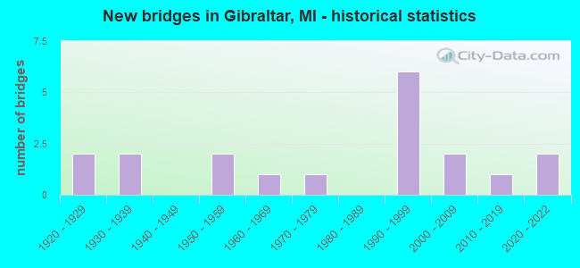
- New bridges - historical statistics
- 21920-1929
- 21930-1939
- 21950-1959
- 11960-1969
- 11970-1979
- 61990-1999
- 22000-2009
- 12010-2019
- 22020-2022


- Bridge Condition - Deck
- 9.1%Excellent
- 9.1%Very good
- 18.2%Good
- 9.1%Satisfactory
- 36.4%Fair
- 18.2%Poor

- Bridge Condition - Superstructure
- 8.3%Excellent
- 8.3%Very good
- 16.7%Good
- 8.3%Satisfactory
- 33.3%Fair
- 25.0%Poor

- Bridge Condition - Substructure
- 8.3%Excellent
- 8.3%Very good
- 8.3%Good
- 33.3%Satisfactory
- 16.7%Fair
- 25.0%Poor

- Bridge Condition - Channel
- 5.3%Excellent
- 21.1%Very good
- 36.8%Good
- 26.3%Satisfactory
- 10.5%Fair

- Bridge Condition - Culverts
- 14.3%Excellent
- 14.3%Very good
- 42.9%Good
- 14.3%Satisfactory
- 14.3%Fair
Find on map >> Show street view
Structure Number: 12, Location: 1.8 W & 0.3 S OF ALCONA (Lat: 44.750919, Lng: -83.335767), Route carried "on" structure: County highway 166, Year Built: 1994, Status: Open, Structure Length: 0.88m (2.89ft), Average Daily Traffic: 211 (year 2003), Truck Traffic: 20%, Average Future Daily Traffic: 290 (year 2023), Design Load: HS 20, Features Intersected: BLACK RIVER, Facility Carried by Structure: SHAW ROAD
Minimum Vertical Clearance: 30.48m (100.00ft), Kilometerpoint: 5.456, Lanes on structure: 2, Owner: County Highway Agency, Approaching Roadway Width: 11.6m (38.1ft), Skew: 1 degrees, Material/Design: Wood or Timber, Design/Construction: Slab, Number Of Spans In Main Unit: 1, Length of Maximum Span: 8.5m (27.9ft), Curb or Sidewalk Widths: Left: 0.4m (1.3ft), Right: 0.4m (1.3ft), Curb-To-Curb Width: 9.1m (29.9ft), Out-to-Out Width: 10.5m (34.4ft)
Condition: Deck: Good, Superstructure: Good, Substructure: Good, Channel: Good, Operating Rating: 51.0 metric tons, Method Used To Determine Operating Rating: Allowable Stress (AS), Inventory Rating: 35.0 metric tons, Method Used To Determine Inventory Rating: Allowable Stress (AS), Structural Evaluation: Better than present minimum criteria, Deck Geometry: Equal to present minimum criteria, Waterway Adequacy: Equal to present desirable criteria, Approach Roadway Alignment: Better than present minimum criteria, Designated Inspection Frequency: Every 24 months, Inspection Date: May 2021, Deck Structure Type: Wood or Timber, Wearing Surface/Protective System: Wearing Surface: Bituminous
Find on map >> Show street view
Structure Number: 5046, Location: 200 FT S OF 12 MILE ROAD (Lat: 43.145136, Lng: -85.690375), Route carried "on" structure: County highway 4119, Year Built: 1956, Year Reconstructed: 1972, Status: Open, Structure Length: 0.61m (2.00ft), Average Daily Traffic: 4,436 (year 2004), Average Future Daily Traffic: 7,540 (year 2024), Design Load: HS 20+Mod, Features Intersected: UNNAMED CREEK, Facility Carried by Structure: ALPINE AVE
Minimum Vertical Clearance: 30.48m (100.00ft), Kilometerpoint: 5.863, Lanes on structure: 2, Owner: County Highway Agency, Approaching Roadway Width: 13.4m (44.0ft), Material/Design: Steel, Design/Construction: Culvert, Number Of Spans In Main Unit: 2, Length of Maximum Span: 2.7m (8.9ft)
Condition: Channel: Good, Culverts: Satisfactory, Operating Rating: 97.2 metric tons, Method Used To Determine Operating Rating: Load Factor (LF) rating reported by rating factor (RF) method using MS18 loading, Inventory Rating: 97.2 metric tons, Method Used To Determine Inventory Rating: Load Factor (LF) rating reported by rating factor (RF) method using MS18 loading, Structural Evaluation: Equal to present minimum criteria, Waterway Adequacy: Equal to present desirable criteria, Approach Roadway Alignment: Equal to present desirable criteria, Designated Inspection Frequency: Every 24 months, Inspection Date: October 2021
Find on map >> Show street view
Structure Number: 11785, Location: 0.5 MI SW OF TRENTON (Lat: 42.106358, Lng: -83.218981), Route carried "on" structure: State highway 85, Year Built: 2016, Status: Open, Structure Length: 1.31m (4.30ft), Average Daily Traffic: 15,575 (year 2014), Truck Traffic: 7%, Average Future Daily Traffic: 17,325 (year 2036), Design Load: Greater than HL93, Features Intersected: MARSH CREEK
Minimum Vertical Clearance: 30.48m (100.00ft), Kilometerpoint: 3.708, Lanes on structure: 2, Base Highway Network: Yes (Inventory Route: 159, Subroute: 5), Owner: State Highway Agency, Approaching Roadway Width: 12.8m (42.0ft), Material/Design: Prestressed concrete, Design/Construction: Box Beam or Girders - Single/Spread, Number Of Spans In Main Unit: 1, Length of Maximum Span: 11.9m (39.0ft), Curb-To-Curb Width: 12.8m (42.0ft), Out-to-Out Width: 13.8m (45.3ft)
Condition: Deck: Very good, Superstructure: Very good, Substructure: Very good, Channel: Good, Operating Rating: 71.6 metric tons, Method Used To Determine Operating Rating: Load and Resistance Factor Rating (LRFR) rating reported by rating factor(RF) method using HL-93 loadings, Inventory Rating: 54.4 metric tons, Method Used To Determine Inventory Rating: Load and Resistance Factor Rating (LRFR) rating reported by rating factor(RF) method using HL-93 loadings, Structural Evaluation: Equal to present desirable criteria, Deck Geometry: Equal to present desirable criteria, Waterway Adequacy: Equal to present desirable criteria, Approach Roadway Alignment: Equal to present desirable criteria, Designated Inspection Frequency: Every 24 months, Inspection Date: May 2020, Deck Structure Type: Concrete Cast-file-Place, Wearing Surface/Protective System: Wearing Surface: Monolithic Concrete, Deck Protection: Epoxy Coated Reinforcing
Find on map >> Show street view
Structure Number: 11786, Location: .5 MI SW OF TRENTON (Lat: 42.106678, Lng: -83.219536), Route carried "on" structure: State highway 85, Year Built: 1958, Status: Open, Structure Length: 1.31m (4.30ft), Average Daily Traffic: 15,575 (year 2014), Truck Traffic: 7%, Average Future Daily Traffic: 17,325 (year 2036), Design Load: HS 20+Mod, Features Intersected: MARSH CREEK
Minimum Vertical Clearance: 30.48m (100.00ft), Kilometerpoint: 3.496, Lanes on structure: 2, Base Highway Network: Yes (Inventory Route: 159, Subroute: 6), Owner: State Highway Agency, Approaching Roadway Width: 11.6m (38.1ft), Skew: 2 degrees, Material/Design: Concrete, Design/Construction: Slab, Number Of Spans In Main Unit: 1, Length of Maximum Span: 13.1m (43.0ft), Curb-To-Curb Width: 13.1m (43.0ft), Out-to-Out Width: 14.2m (46.6ft)
Condition: Deck: Good, Superstructure: Fair, Substructure: Satisfactory, Channel: Good, Operating Rating: 64.5 metric tons, Method Used To Determine Operating Rating: Load Factor (LF) rating reported by rating factor (RF) method using MS18 loading, Inventory Rating: 38.6 metric tons, Method Used To Determine Inventory Rating: Load Factor (LF) rating reported by rating factor (RF) method using MS18 loading, Structural Evaluation: Somewhat better than minimum adequacy, Deck Geometry: Superior to present desirable criteria, Waterway Adequacy: Equal to present desirable criteria, Approach Roadway Alignment: Equal to present desirable criteria, Designated Inspection Frequency: Every 24 months, Inspection Date: May 2020, Deck Structure Type: Concrete Cast-file-Place, Wearing Surface/Protective System: Wearing Surface: Latex Concrete
Find on map >> Show street view
Structure Number: 11987, Location: BROWNSTOWNE/DERN (Lat: 42.052039, Lng: -83.191078), Route carried "on" structure: County highway , Year Built: 2002, Status: Open, Structure Length: 1.37m (4.49ft), Average Daily Traffic: 760 (year 2002), Truck Traffic: 1%, Average Future Daily Traffic: 760 (year 2020), Design Load: HS 20+Mod, Features Intersected: CANAL (MIDDLE), Facility Carried by Structure: MARLEY DRIVE
Minimum Vertical Clearance: 30.48m (100.00ft), Kilometerpoint: 0.208, Lanes on structure: 2, Owner: County Highway Agency, Approaching Roadway Width: 9.1m (29.9ft), Material/Design: Concrete, Design/Construction: Culvert, Number Of Spans In Main Unit: 1, Length of Maximum Span: 12.8m (42.0ft), Curb or Sidewalk Widths: Left: 1.3m (4.3ft), Right: 1.3m (4.3ft), Curb-To-Curb Width: 7.3m (24.0ft), Out-to-Out Width: 11.0m (36.1ft)
Condition: Channel: Good, Culverts: Good, Operating Rating: 60.9 metric tons, Method Used To Determine Operating Rating: Load Factor (LF) rating reported by rating factor (RF) method using MS18 loading, Inventory Rating: 36.3 metric tons, Method Used To Determine Inventory Rating: Load Factor (LF) rating reported by rating factor (RF) method using MS18 loading, Structural Evaluation: Better than present minimum criteria, Waterway Adequacy: Equal to present desirable criteria, Approach Roadway Alignment: Equal to present minimum criteria, Designated Inspection Frequency: Every 24 months, Underwater Inspection Frequency: Every 60 months, Inspection Date: September 2020, Underwater Inspection Date: November 2018, Deck Structure Type: Concrete Cast-file-Place, Wearing Surface/Protective System: Wearing Surface: Epoxy Overlay, Membrane: Epoxy, Deck Protection: Bituminous
Find on map >> Show street view
Structure Number: 11988, Location: BROWNSTOWNE/MARCUS (Lat: 42.052092, Lng: -83.188831), Route carried "on" structure: County highway , Year Built: 2002, Status: Open, Structure Length: 1.37m (4.49ft), Average Daily Traffic: 760 (year 2002), Truck Traffic: 1%, Average Future Daily Traffic: 760 (year 2020), Design Load: HS 20+Mod, Features Intersected: CANAL (EAST), Facility Carried by Structure: MARLEY DRIVE
Minimum Vertical Clearance: 30.48m (100.00ft), Kilometerpoint: 0.394, Lanes on structure: 2, Owner: County Highway Agency, Approaching Roadway Width: 9.1m (29.9ft), Material/Design: Concrete, Design/Construction: Culvert, Number Of Spans In Main Unit: 1, Length of Maximum Span: 12.8m (42.0ft), Curb or Sidewalk Widths: Left: 1.3m (4.3ft), Right: 1.3m (4.3ft), Curb-To-Curb Width: 7.3m (24.0ft), Out-to-Out Width: 11.0m (36.1ft)
Condition: Channel: Very good, Culverts: Good, Operating Rating: 60.9 metric tons, Method Used To Determine Operating Rating: Load Factor (LF) rating reported by rating factor (RF) method using MS18 loading, Inventory Rating: 36.3 metric tons, Method Used To Determine Inventory Rating: Load Factor (LF) rating reported by rating factor (RF) method using MS18 loading, Structural Evaluation: Better than present minimum criteria, Waterway Adequacy: Equal to present desirable criteria, Approach Roadway Alignment: Equal to present minimum criteria, Designated Inspection Frequency: Every 24 months, Underwater Inspection Frequency: Every 60 months, Inspection Date: September 2020, Underwater Inspection Date: November 2018, Deck Structure Type: Concrete Cast-file-Place, Wearing Surface/Protective System: Wearing Surface: Epoxy Overlay, Membrane: Epoxy, Deck Protection: Bituminous
Find on map >> Show street view
Structure Number: 11992, Location: GIBRALTAR W/JEFFERSON (Lat: 42.095306, Lng: -83.211000), Route carried "on" structure: City street 2057, Year Built: 1976, Status: Open, Structure Length: 2.74m (8.99ft), Average Daily Traffic: 9,406 (year 1996), Truck Traffic: 2%, Average Future Daily Traffic: 13,450 (year 2015), Design Load: HS 20+Mod, Features Intersected: BROWNSTOWN CREEK, Facility Carried by Structure: GIBRALTAR ROAD
Minimum Vertical Clearance: 30.48m (100.00ft), Kilometerpoint: 0.385, Lanes on structure: 2, Owner: County Highway Agency, Approaching Roadway Width: 8.5m (27.9ft), Skew: 1 degrees, Material/Design: Concrete, Design/Construction: Slab, Number Of Spans In Main Unit: 3, Length of Maximum Span: 10.0m (32.8ft), Curb or Sidewalk Widths: Left: 0.2m (0.7ft), Right: 0.2m (0.7ft), Curb-To-Curb Width: 8.5m (27.9ft), Out-to-Out Width: 15.9m (52.2ft)
Condition: Deck: Poor, Superstructure: Poor, Substructure: Satisfactory, Channel: Satisfactory, Operating Rating: 56.1 metric tons, Method Used To Determine Operating Rating: Load Factor (LF) rating reported by rating factor (RF) method using MS18 loading, Inventory Rating: 33.7 metric tons, Method Used To Determine Inventory Rating: Load Factor (LF) rating reported by rating factor (RF) method using MS18 loading, Structural Evaluation: Meets minimum limits, Deck Geometry: High priority of replacement, Waterway Adequacy: Equal to present desirable criteria, Approach Roadway Alignment: Equal to present desirable criteria, Designated Inspection Frequency: Every 12 months, Inspection Date: November 2021, Deck Structure Type: Concrete Cast-file-Place, Wearing Surface/Protective System: Wearing Surface: Bituminous, Membrane: Preformed Fabric
Find on map >> Show street view
Structure Number: 11993, Location: GIBRALTAR E/JEFFERSON (Lat: 42.085400, Lng: -83.205700), Route carried "on" structure: City street 2057, Year Built: 1992, Status: Open, Structure Length: 1.04m (3.41ft), Average Daily Traffic: 2,926 (year 1996), Truck Traffic: 1%, Average Future Daily Traffic: 1,751 (year 2015), Design Load: HS 20+Mod, Features Intersected: BLAKELY DRAIN, Facility Carried by Structure: S GIBRALTAR
Minimum Vertical Clearance: 30.48m (100.00ft), Kilometerpoint: 6.555, Lanes on structure: 2, Owner: City or Municipal Highway Agency, Approaching Roadway Width: 8.5m (27.9ft), Material/Design: Concrete, Design/Construction: Culvert, Number Of Spans In Main Unit: 1, Length of Maximum Span: 10.0m (32.8ft), Curb or Sidewalk Widths: Left: 1.8m (5.9ft), Right: 1.8m (5.9ft), Curb-To-Curb Width: 8.5m (27.9ft), Out-to-Out Width: 12.9m (42.3ft)
Condition: Channel: Good, Culverts: Good, Operating Rating: 54.5 metric tons, Method Used To Determine Operating Rating: Field evaluation and documented engineering judgment, Inventory Rating: 32.7 metric tons, Method Used To Determine Inventory Rating: Field evaluation and documented engineering judgment, Structural Evaluation: Better than present minimum criteria, Deck Geometry: Meets minimum limits, Waterway Adequacy: Equal to present desirable criteria, Approach Roadway Alignment: Equal to present desirable criteria, Designated Inspection Frequency: Every 24 months, Underwater Inspection Frequency: Every 60 months, Inspection Date: August 2021, Underwater Inspection Date: October 2021, Deck Structure Type: Concrete Cast-file-Place, Wearing Surface/Protective System: Wearing Surface: Bituminous
Find on map >> Show street view
Structure Number: 11994, Location: GIBRALTAR E/JEFFERSON (Lat: 42.087828, Lng: -83.200025), Route carried "on" structure: City street 2057, Year Built: 1992, Status: Open, Structure Length: 0.83m (2.72ft), Average Daily Traffic: 2,929 (year 1996), Truck Traffic: 1%, Average Future Daily Traffic: 1,751 (year 2015), Design Load: HS 20+Mod, Features Intersected: FRANK & POET DRAIN, Facility Carried by Structure: S GIBRALTAR
Minimum Vertical Clearance: 30.48m (100.00ft), Kilometerpoint: 0.906, Lanes on structure: 2, Owner: City or Municipal Highway Agency, Approaching Roadway Width: 8.5m (27.9ft), Material/Design: Concrete, Design/Construction: Culvert, Number Of Spans In Main Unit: 1, Length of Maximum Span: 7.4m (24.3ft), Curb or Sidewalk Widths: Left: 1.8m (5.9ft), Right: 1.8m (5.9ft), Curb-To-Curb Width: 8.5m (27.9ft), Out-to-Out Width: 12.8m (42.0ft)
Condition: Channel: Satisfactory, Culverts: Very good, Operating Rating: 61.7 metric tons, Method Used To Determine Operating Rating: Field evaluation and documented engineering judgment, Inventory Rating: 45.4 metric tons, Method Used To Determine Inventory Rating: Field evaluation and documented engineering judgment, Structural Evaluation: Equal to present desirable criteria, Deck Geometry: Meets minimum limits, Waterway Adequacy: Better than present minimum criteria, Approach Roadway Alignment: Equal to present desirable criteria, Designated Inspection Frequency: Every 24 months, Underwater Inspection Frequency: Every 60 months, Inspection Date: August 2021, Underwater Inspection Date: August 2019, Deck Structure Type: Concrete Cast-file-Place, Wearing Surface/Protective System: Wearing Surface: Bituminous
Find on map >> Show street view
Structure Number: 11995, Location: GIBRALTAR E/S GIBRALTAR (Lat: 42.090386, Lng: -83.193144), Route carried "on" structure: City street 8206, Year Built: 1992, Status: Open, Structure Length: 0.82m (2.69ft), Average Daily Traffic: 2,690 (year 1996), Truck Traffic: 1%, Average Future Daily Traffic: 3,041 (year 2015), Design Load: HS 25 or greater, Features Intersected: W GIBRALTAR WATERWAY, Facility Carried by Structure: STOEFLET ROAD
Minimum Vertical Clearance: 30+ m (98+ ft), Kilometerpoint: 0.653, Lanes on structure: 2, Owner: City or Municipal Highway Agency, Approaching Roadway Width: 11.0m (36.1ft), Material/Design: Prestressed concrete, Design/Construction: Box Beam or Girders - Multiple, Number Of Spans In Main Unit: 1, Length of Maximum Span: 7.6m (24.9ft), Curb or Sidewalk Widths: Left: 1.7m (5.6ft), Right: 1.7m (5.6ft), Curb-To-Curb Width: 7.3m (24.0ft), Out-to-Out Width: 11.5m (37.7ft)
Condition: Deck: Fair, Superstructure: Satisfactory, Substructure: Satisfactory, Channel: Very good, Operating Rating: 97.2 metric tons, Method Used To Determine Operating Rating: Load Factor (LF) rating reported by rating factor (RF) method using MS18 loading, Inventory Rating: 72.9 metric tons, Method Used To Determine Inventory Rating: Load Factor (LF) rating reported by rating factor (RF) method using MS18 loading, Structural Evaluation: Equal to present minimum criteria, Deck Geometry: High priority of replacement, Waterway Adequacy: Better than present minimum criteria, Approach Roadway Alignment: Equal to present desirable criteria, Designated Inspection Frequency: Every 24 months, Underwater Inspection Frequency: Every 60 months, Inspection Date: August 2021, Underwater Inspection Date: August 2019, Deck Structure Type: Concrete Cast-file-Place, Wearing Surface/Protective System: Wearing Surface: Monolithic Concrete, Deck Protection: Epoxy Coated Reinforcing
Find on map >> Show street view
Structure Number: 11996, Location: GIBRALTAR, W/BAYVIEW (Lat: 42.089958, Lng: -83.191428), Route carried "on" structure: City street 8206, Year Built: 1992, Status: Open, Structure Length: 0.82m (2.69ft), Average Daily Traffic: 2,690 (year 1996), Truck Traffic: 1%, Average Future Daily Traffic: 3,041 (year 2015), Design Load: HS 25 or greater, Features Intersected: E GIBRALTAR WATERWAY, Facility Carried by Structure: STOEFLET ROAD
Minimum Vertical Clearance: 30+ m (98+ ft), Kilometerpoint: 0.785, Lanes on structure: 2, Owner: City or Municipal Highway Agency, Approaching Roadway Width: 11.0m (36.1ft), Material/Design: Prestressed concrete, Design/Construction: Box Beam or Girders - Multiple, Number Of Spans In Main Unit: 1, Length of Maximum Span: 7.6m (24.9ft), Curb or Sidewalk Widths: Left: 1.7m (5.6ft), Right: 1.7m (5.6ft), Curb-To-Curb Width: 7.3m (24.0ft), Out-to-Out Width: 11.5m (37.7ft)
Condition: Deck: Fair, Superstructure: Good, Substructure: Satisfactory, Channel: Very good, Operating Rating: 97.2 metric tons, Method Used To Determine Operating Rating: Load Factor (LF) rating reported by rating factor (RF) method using MS18 loading, Inventory Rating: 72.9 metric tons, Method Used To Determine Inventory Rating: Load Factor (LF) rating reported by rating factor (RF) method using MS18 loading, Structural Evaluation: Equal to present minimum criteria, Deck Geometry: High priority of replacement, Waterway Adequacy: Better than present minimum criteria, Approach Roadway Alignment: Equal to present desirable criteria, Designated Inspection Frequency: Every 24 months, Underwater Inspection Frequency: Every 60 months, Inspection Date: August 2021, Underwater Inspection Date: August 2021, Deck Structure Type: Concrete Cast-file-Place, Wearing Surface/Protective System: Wearing Surface: Monolithic Concrete, Deck Protection: Epoxy Coated Reinforcing
Find on map >> Show street view
Structure Number: 11997, Location: GIBRALTAR E/JEFFERSON (Lat: 42.094689, Lng: -83.202753), Route carried "on" structure: City street 2057, Year Built: 1932, Status: Open, Structure Length: 0.83m (2.72ft), Average Daily Traffic: 3,208 (year 1996), Truck Traffic: 2%, Average Future Daily Traffic: 8,274 (year 2015), Design Load: HS 20+Mod, Features Intersected: FRANK & POET DRAIN, Facility Carried by Structure: GIBRALTAR ROAD
Minimum Vertical Clearance: 30+ m (98+ ft), Kilometerpoint: 7.244, Lanes on structure: 4, Owner: City or Municipal Highway Agency, Approaching Roadway Width: 8.8m (28.9ft), Material/Design: Concrete, Design/Construction: Tee Beam, Number Of Spans In Main Unit: 1, Length of Maximum Span: 7.4m (24.3ft), Curb or Sidewalk Widths: Left: 1.7m (5.6ft), Right: 1.7m (5.6ft), Curb-To-Curb Width: 12.2m (40.0ft), Out-to-Out Width: 17.0m (55.8ft)
Condition: Deck: Poor, Superstructure: Poor, Substructure: Poor, Channel: Good, Operating Rating: 64.2 metric tons, Method Used To Determine Operating Rating: Load Factor (LF) rating reported by rating factor (RF) method using MS18 loading, Inventory Rating: 38.2 metric tons, Method Used To Determine Inventory Rating: Load Factor (LF) rating reported by rating factor (RF) method using MS18 loading, Structural Evaluation: Meets minimum limits, Deck Geometry: High priority of replacement, Waterway Adequacy: Better than present minimum criteria, Approach Roadway Alignment: Equal to present desirable criteria, Designated Inspection Frequency: Every 12 months, Underwater Inspection Frequency: Every 60 months, Inspection Date: August 2021, Underwater Inspection Date: August 2021, Deck Structure Type: Concrete Cast-file-Place, Wearing Surface/Protective System: Wearing Surface: Bituminous
Find on map >> Show street view
Structure Number: 11998, Location: GIBRALTAR E/N GIBRALTAR (Lat: 42.094947, Lng: -83.190658), Route carried "on" structure: City street 2057, Year Built: 2021, Status: Open, Structure Length: 2.13m (6.99ft), Average Daily Traffic: 5,546 (year 1989), Truck Traffic: 1%, Average Future Daily Traffic: 6,379 (year 2015), Design Load: Greater than HL93, Features Intersected: WATERWAY CANAL, Facility Carried by Structure: GIBRALTAR ROAD
Minimum Vertical Clearance: 30.48m (100.00ft), Kilometerpoint: 8.253, Lanes on structure: 2, Owner: City or Municipal Highway Agency, Approaching Roadway Width: 9.1m (29.9ft), Skew: 2 degrees, Material/Design: Prestressed concrete, Design/Construction: Box Beam or Girders - Multiple, Number Of Spans In Main Unit: 1, Length of Maximum Span: 20.4m (66.9ft), Curb or Sidewalk Widths: Left: 2.4m (7.9ft), Right: 2.4m (7.9ft), Curb-To-Curb Width: 9.1m (29.9ft), Out-to-Out Width: 14.6m (47.9ft)
Condition: Deck: Excellent, Superstructure: Excellent, Substructure: Excellent, Channel: Excellent, Operating Rating: 68.4 metric tons, Method Used To Determine Operating Rating: Load and Resistance Factor Rating (LRFR) rating reported by rating factor(RF) method using HL-93 loadings, Inventory Rating: 52.5 metric tons, Method Used To Determine Inventory Rating: Load and Resistance Factor Rating (LRFR) rating reported by rating factor(RF) method using HL-93 loadings, Structural Evaluation: Superior to present desirable criteria, Deck Geometry: High priority of corrective action, Waterway Adequacy: Equal to present minimum criteria, Approach Roadway Alignment: Equal to present desirable criteria, Designated Inspection Frequency: Every 24 months, Inspection Date: Febuary 2022, Deck Structure Type: Concrete Cast-file-Place, Wearing Surface/Protective System: Wearing Surface: Monolithic Concrete, Deck Protection: Epoxy Coated Reinforcing
Find on map >> Show street view
Structure Number: 12, Location: GIBRALTAR/TRENTON E/FORT (Lat: 42.112131, Lng: -83.205436), Route carried "on" structure: County highway 2057, Year Built: 1965, Status: Open, Structure Length: 0.70m (2.30ft), Average Daily Traffic: 5,617 (year 1995), Truck Traffic: 2%, Average Future Daily Traffic: 3,092 (year 2015), Design Load: HS 20+Mod, Features Intersected: FRANK & POET DRAIN, Facility Carried by Structure: VREELAND ROAD
Minimum Vertical Clearance: 30.48m (100.00ft), Kilometerpoint: 6.639, Lanes on structure: 2, Owner: County Highway Agency, Approaching Roadway Width: 12.2m (40.0ft), Material/Design: Steel, Design/Construction: Culvert, Number Of Spans In Main Unit: 3, Length of Maximum Span: 2.1m (6.9ft), Curb-To-Curb Width: 11.6m (38.1ft), Out-to-Out Width: 12.2m (40.0ft)
Condition: Channel: Satisfactory, Culverts: Fair, Operating Rating: 97.2 metric tons, Method Used To Determine Operating Rating: Load and Resistance Factor Rating (LRFR) rating reported by rating factor(RF) method using HL-93 loadings, Inventory Rating: 95.3 metric tons, Method Used To Determine Inventory Rating: Load and Resistance Factor Rating (LRFR) rating reported by rating factor(RF) method using HL-93 loadings, Structural Evaluation: Somewhat better than minimum adequacy, Deck Geometry: Somewhat better than minimum adequacy, Waterway Adequacy: Meets minimum limits, Approach Roadway Alignment: Equal to present minimum criteria, Designated Inspection Frequency: Every 24 months, Inspection Date: May 2020
Find on map >> Show street view
Structure Number: 12184, Location: BROWNSTOWN S/VREELAND (Lat: 42.104108, Lng: -83.224839), Route carried "on" structure: County highway 2057, Year Built: 2020, Status: Open, Structure Length: 0.78m (2.56ft), Average Daily Traffic: 14,720 (year 2018), Truck Traffic: 8%, Average Future Daily Traffic: 16,430 (year 2039), Design Load: Greater than HL93, Features Intersected: BROWNSTOWN CREEK, Facility Carried by Structure: ALLEN ROAD
Minimum Vertical Clearance: 30.48m (100.00ft), Kilometerpoint: 0.480, Lanes on structure: 2, Owner: County Highway Agency, Approaching Roadway Width: 12.2m (40.0ft), Skew: 4 degrees, Material/Design: Concrete, Design/Construction: Culvert, Number Of Spans In Main Unit: 1, Length of Maximum Span: 7.8m (25.6ft), Curb-To-Curb Width: 12.2m (40.0ft), Out-to-Out Width: 22.2m (72.8ft)
Condition: Channel: Very good, Culverts: Excellent, Operating Rating: 71.9 metric tons, Method Used To Determine Operating Rating: Load and Resistance Factor Rating (LRFR) rating reported by rating factor(RF) method using HL-93 loadings, Inventory Rating: 55.7 metric tons, Method Used To Determine Inventory Rating: Load and Resistance Factor Rating (LRFR) rating reported by rating factor(RF) method using HL-93 loadings, Structural Evaluation: Superior to present desirable criteria, Deck Geometry: Somewhat better than minimum adequacy, Waterway Adequacy: Equal to present minimum criteria, Approach Roadway Alignment: Equal to present desirable criteria, Designated Inspection Frequency: Every 24 months, Inspection Date: August 2020, Wearing Surface/Protective System: Wearing Surface: Low Slump Concrete, Membrane: Preformed Fabric
Find on map >> Show street view
Structure Number: 12198, Location: GIBRALTAR S/GIBRALTAR RD (Lat: 42.087108, Lng: -83.207639), Route carried "on" structure: County highway 2057, Year Built: 1924, Status: Open, Structure Length: 1.49m (4.89ft), Average Daily Traffic: 10,048 (year 1995), Truck Traffic: 7%, Average Future Daily Traffic: 7,063 (year 2015), Features Intersected: BLAKELY DRAIN, Facility Carried by Structure: JEFFERSON AVENUE
Minimum Vertical Clearance: 30.48m (100.00ft), Kilometerpoint: 5.224, Lanes on structure: 2, Owner: County Highway Agency, Approaching Roadway Width: 14.0m (45.9ft), Skew: 4 degrees, Material/Design: Concrete, Design/Construction: Tee Beam, Number Of Spans In Main Unit: 1, Length of Maximum Span: 12.2m (40.0ft), Curb or Sidewalk Widths: Left: 0.8m (2.6ft), Right: 0.8m (2.6ft), Curb-To-Curb Width: 12.2m (40.0ft), Out-to-Out Width: 14.0m (45.9ft)
Condition: Deck: Fair, Superstructure: Fair, Substructure: Fair, Channel: Fair, Operating Rating: 61.6 metric tons, Method Used To Determine Operating Rating: Load Factor (LF) rating reported by rating factor (RF) method using MS18 loading, Inventory Rating: 36.9 metric tons, Method Used To Determine Inventory Rating: Load Factor (LF) rating reported by rating factor (RF) method using MS18 loading, Structural Evaluation: Somewhat better than minimum adequacy, Deck Geometry: Somewhat better than minimum adequacy, Waterway Adequacy: Equal to present minimum criteria, Approach Roadway Alignment: Equal to present desirable criteria, Designated Inspection Frequency: Every 24 months, Underwater Inspection Frequency: Every 60 months, Inspection Date: September 2020, Underwater Inspection Date: November 2018, Deck Structure Type: Concrete Cast-file-Place, Wearing Surface/Protective System: Wearing Surface: Integral Concrete
Find on map >> Show street view
Structure Number: 12199, Location: GIBRALTAR N/GIBRALTAR (Lat: 42.095233, Lng: -83.203178), Route carried "on" structure: County highway 2057, Year Built: 1936, Status: Open, Structure Length: 0.64m (2.10ft), Average Daily Traffic: 14,984 (year 1995), Truck Traffic: 5%, Average Future Daily Traffic: 6,601 (year 2015), Design Load: HS 20+Mod, Features Intersected: FRANK & POET DRAIN, Facility Carried by Structure: JEFFERSON AVENUE
Minimum Vertical Clearance: 30.48m (100.00ft), Kilometerpoint: 6.199, Lanes on structure: 3, Owner: County Highway Agency, Approaching Roadway Width: 16.1m (52.8ft), Material/Design: Concrete, Design/Construction: Slab, Number Of Spans In Main Unit: 1, Length of Maximum Span: 5.4m (17.7ft), Curb or Sidewalk Widths: Left: 0.2m (0.7ft), Right: 1.5m (4.9ft), Curb-To-Curb Width: 15.9m (52.2ft), Out-to-Out Width: 17.7m (58.1ft)
Condition: Deck: Fair, Superstructure: Fair, Substructure: Fair, Channel: Fair, Operating Rating: 57.0 metric tons, Method Used To Determine Operating Rating: Load Factor (LF) rating reported by rating factor (RF) method using MS18 loading, Inventory Rating: 34.3 metric tons, Method Used To Determine Inventory Rating: Load Factor (LF) rating reported by rating factor (RF) method using MS18 loading, Structural Evaluation: Somewhat better than minimum adequacy, Deck Geometry: Better than present minimum criteria, Waterway Adequacy: High priority of corrective action, Approach Roadway Alignment: Equal to present desirable criteria, Designated Inspection Frequency: Every 24 months, Underwater Inspection Frequency: Every 60 months, Inspection Date: September 2020, Underwater Inspection Date: November 2018, Deck Structure Type: Concrete Cast-file-Place, Wearing Surface/Protective System: Wearing Surface: Bituminous
Find on map >> Show street view
Structure Number: 12495, Location: EAST OF ADAMS (Lat: 42.086736, Lng: -83.186142), Route carried "on" structure: City street , Year Built: 1925, Status: Posted for load, Structure Length: 1.40m (4.59ft), Average Daily Traffic: 350 (year 1992), Truck Traffic: 1%, Average Future Daily Traffic: 400 (year 2012), Design Load: H 15, Features Intersected: HORSE ISL & ADAMS DR BYU, Facility Carried by Structure: HORSE ISLAND DRIVE
Minimum Vertical Clearance: 30.48m (100.00ft), Kilometerpoint: 0.462, Lanes on structure: 1, Owner: City or Municipal Highway Agency, Approaching Roadway Width: 6.7m (22.0ft), Skew: 2 degrees, Material/Design: Concrete, Design/Construction: Arch - Deck, Number Of Spans In Main Unit: 1, Length of Maximum Span: 12.2m (40.0ft), Curb-To-Curb Width: 6.0m (19.7ft), Out-to-Out Width: 7.0m (23.0ft)
Condition: Superstructure: Poor, Substructure: Poor, Channel: Satisfactory, Operating Rating: 99.1 metric tons, Method Used To Determine Operating Rating: Load Factor (LF), Inventory Rating: 58.0 metric tons, Method Used To Determine Inventory Rating: Load Factor (LF), Structural Evaluation: Meets minimum limits, Deck Geometry: High priority of corrective action, Waterway Adequacy: Equal to present minimum criteria, Approach Roadway Alignment: Meets minimum limits, Length Of Structure Improvement: 2.13m (6.99ft), Designated Inspection Frequency: Every 12 months, Underwater Inspection Frequency: Every 60 months, Inspection Date: August 2021, Underwater Inspection Date: August 2020, Bridge Improvement Cost: $700,000, Roadway Improvement Cost: $200,000, Total Project Cost: $900,000, Deck Structure Type: Concrete Cast-file-Place, Wearing Surface/Protective System: Wearing Surface: Bituminous, Membrane: Preformed Fabric
Find on map >> Show street view
Structure Number: 12496, Location: EAST OF WORTH (Lat: 42.085514, Lng: -83.195783), Route carried "on" structure: City street , Year Built: 1990, Status: Posted for load, Structure Length: 2.35m (7.71ft), Average Daily Traffic: 380 (year 1992), Truck Traffic: 1%, Average Future Daily Traffic: 400 (year 2012), Design Load: HS 20, Features Intersected: W GIBRALTAR WATERWAY, Facility Carried by Structure: YOUNG DRIVE
Minimum Vertical Clearance: 30.48m (100.00ft), Kilometerpoint: 0.861, Lanes on structure: 2, Owner: City or Municipal Highway Agency, Approaching Roadway Width: 8.5m (27.9ft), Material/Design: Prestressed concrete, Design/Construction: Box Beam or Girders - Multiple, Number Of Spans In Main Unit: 2, Length of Maximum Span: 11.2m (36.7ft), Curb-To-Curb Width: 8.5m (27.9ft), Out-to-Out Width: 9.5m (31.2ft)
Condition: Deck: Satisfactory, Superstructure: Fair, Substructure: Poor, Channel: Satisfactory, Operating Rating: 21.4 metric tons, Method Used To Determine Operating Rating: Load and Resistance Factor Rating (LRFR) rating reported by rating factor(RF) method using HL-93 loadings, Inventory Rating: 16.5 metric tons, Method Used To Determine Inventory Rating: Load and Resistance Factor Rating (LRFR) rating reported by rating factor(RF) method using HL-93 loadings, Structural Evaluation: Meets minimum limits, Deck Geometry: Equal to present minimum criteria, Waterway Adequacy: Equal to present desirable criteria, Approach Roadway Alignment: Equal to present desirable criteria, Bridge Posting: Required (Relationship of Operating Rating to Maximum Legal Load: > 39.9% below), Designated Inspection Frequency: Every 12 months, Underwater Inspection Frequency: Every 24 months, Inspection Date: August 2021, Underwater Inspection Date: August 2020, Deck Structure Type: Concrete Cast-file-Place, Wearing Surface/Protective System: Wearing Surface: Monolithic Concrete, Deck Protection: Epoxy Coated Reinforcing