Bridge Statistics for Germantown, Wisconsin (WI)
Condition, Traffic, Stress, Structural Evaluation, Project Costs
- National Bridge Inventory (NBI) Statistics
- 30Number of bridges
- 269ft / 82.1mTotal length
- $6,505,000Total costs
- 809,708Total average daily traffic
- 63,711Total average daily truck traffic
- National Bridge Inventory (NBI) Registered Bridges for Germantown
- No street view available for this location
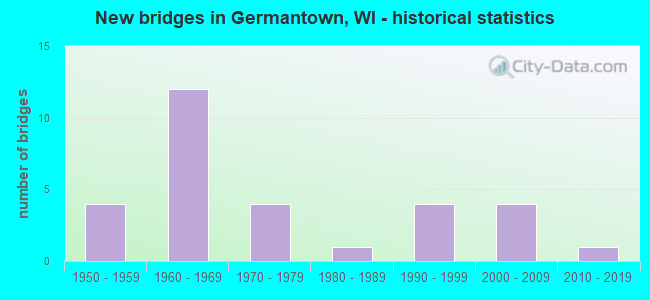
- New bridges - historical statistics
- 41950-1959
- 121960-1969
- 41970-1979
- 11980-1989
- 41990-1999
- 42000-2009
- 12010-2019
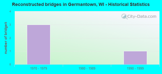
- Reconstructed bridges - Historical Statistics
- 31970-1979
- 01980-1989
- 11990-1999
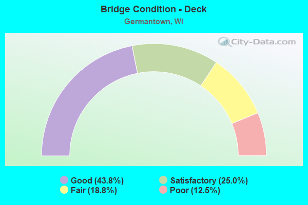
- Bridge Condition - Deck
- 43.8%Good
- 25.0%Satisfactory
- 18.8%Fair
- 12.5%Poor
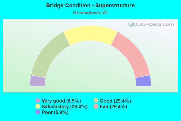
- Bridge Condition - Superstructure
- 5.9%Very good
- 29.4%Good
- 29.4%Satisfactory
- 29.4%Fair
- 5.9%Poor

- Bridge Condition - Substructure
- 5.9%Excellent
- 11.8%Very good
- 23.5%Good
- 35.3%Satisfactory
- 23.5%Fair
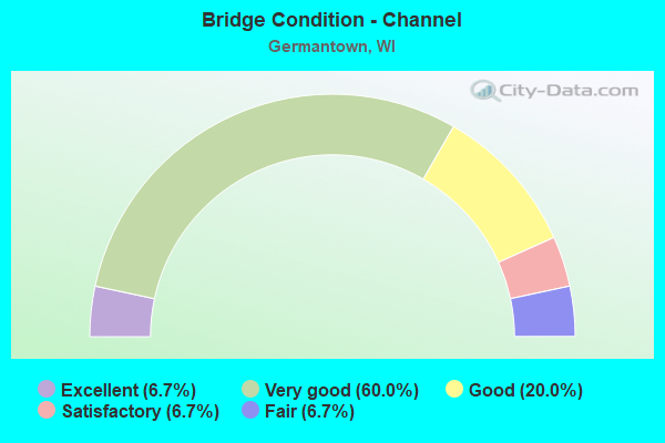
- Bridge Condition - Channel
- 6.7%Excellent
- 60.0%Very good
- 20.0%Good
- 6.7%Satisfactory
- 6.7%Fair
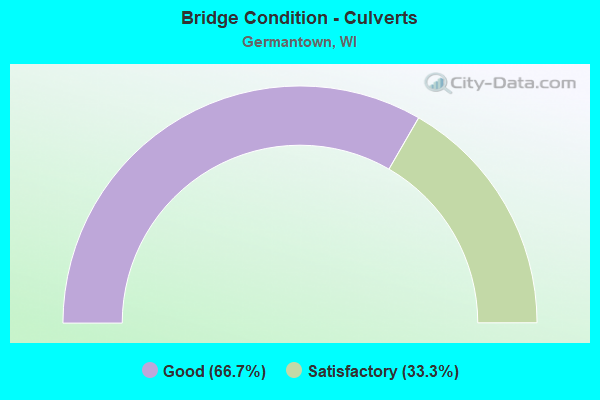
- Bridge Condition - Culverts
- 66.7%Good
- 33.3%Satisfactory
Find on map >> Show street view
Structure Number: B660001, Location: 6.8 MI N JCT STH 74 TO E (Lat: 43.247461, Lng: -88.181453), Route carried "on" structure: Interstate 41, Year Built: 1952, Year Reconstructed: 1970, Status: Open, Structure Length: 5.32m (17.45ft), Average Daily Traffic: 43,700 (year 2019), Truck Traffic: 9%, Average Future Daily Traffic: 52,440 (year 2039), Design Load: HS 20, Features Intersected: WISC & SOUTHERN RR
Minimum Vertical Clearance: 30+ m (98+ ft), Kilometerpoint: 0.000, Lanes on structure: 4, Base Highway Network: Yes, Owner: State Highway Agency, Approaching Roadway Width: 20.1m (65.9ft), Skew: 2 degrees, Material/Design: Steel continuous, Design/Construction: Stringer/Multi-beam, Number Of Spans In Main Unit: 3, Length of Maximum Span: 20.1m (65.9ft), Curb-To-Curb Width: 20.1m (65.9ft), Out-to-Out Width: 21.0m (68.9ft)
Condition: Deck: Satisfactory, Superstructure: Good, Substructure: Satisfactory, Operating Rating: 44.1 metric tons, Method Used To Determine Operating Rating: Load Factor (LF), Inventory Rating: 25.9 metric tons, Method Used To Determine Inventory Rating: Load Factor (LF), Structural Evaluation: Equal to present minimum criteria, Deck Geometry: Equal to present minimum criteria, Underclear: Superior to present desirable criteria, Approach Roadway Alignment: Equal to present desirable criteria, Designated Inspection Frequency: Every 24 months, Inspection Date: August 2021, Deck Structure Type: Concrete Cast-file-Place, Wearing Surface/Protective System: Wearing Surface: Epoxy Overlay
Find on map >> Show street view
Structure Number: B660002, Location: 0.18 MI S JCT STH 167 (Lat: 43.248186, Lng: -88.182092), Route carried "on" structure: Interstate 41, Year Built: 1952, Year Reconstructed: 1970, Status: Open, Structure Length: 5.32m (17.45ft), Average Daily Traffic: 43,700 (year 2019), Truck Traffic: 9%, Average Future Daily Traffic: 52,440 (year 2039), Design Load: HS 20, Features Intersected: WIS & SOUTHERN RR
Minimum Vertical Clearance: 30+ m (98+ ft), Kilometerpoint: 0.000, Lanes on structure: 4, Base Highway Network: Yes, Owner: State Highway Agency, Approaching Roadway Width: 20.1m (65.9ft), Skew: 2 degrees, Material/Design: Steel continuous, Design/Construction: Stringer/Multi-beam, Number Of Spans In Main Unit: 3, Length of Maximum Span: 20.1m (65.9ft), Curb-To-Curb Width: 21.6m (70.9ft), Out-to-Out Width: 22.5m (73.8ft)
Condition: Deck: Satisfactory, Superstructure: Satisfactory, Substructure: Satisfactory, Operating Rating: 42.5 metric tons, Method Used To Determine Operating Rating: Load Factor (LF), Inventory Rating: 24.3 metric tons, Method Used To Determine Inventory Rating: Load Factor (LF), Structural Evaluation: Equal to present minimum criteria, Deck Geometry: Better than present minimum criteria, Underclear: Equal to present desirable criteria, Approach Roadway Alignment: Equal to present desirable criteria, Designated Inspection Frequency: Every 24 months, Inspection Date: September 2020, Deck Structure Type: Concrete Cast-file-Place, Wearing Surface/Protective System: Wearing Surface: Epoxy Overlay
Find on map >> Show street view
Structure Number: B660012, Location: 1.3 MI W JCT CTH Y (Lat: 43.267986, Lng: -88.181472), Route carried "on" structure: City street , Year Built: 1953, Status: Open, Structure Length: 0.88m (2.89ft), Average Daily Traffic: 105 (year 2019), Truck Traffic: 11%, Average Future Daily Traffic: 115 (year 2040), Design Load: HS 20, Features Intersected: BR CEDAR CREEK, Facility Carried by Structure: LRD SHADOW LANE
Minimum Vertical Clearance: 30+ m (98+ ft), Kilometerpoint: 0.000, Lanes on structure: 2, Owner: City or Municipal Highway Agency, Approaching Roadway Width: 10.4m (34.1ft), Skew: 4 degrees, Material/Design: Steel, Design/Construction: Stringer/Multi-beam, Number Of Spans In Main Unit: 1, Length of Maximum Span: 8.5m (27.9ft), Curb or Sidewalk Widths: Left: 1.1m (3.6ft), Right: 1.1m (3.6ft), Curb-To-Curb Width: 11.2m (36.7ft), Out-to-Out Width: 13.3m (43.6ft)
Condition: Deck: Fair, Superstructure: Fair, Substructure: Satisfactory, Channel: Good, Operating Rating: 60.4 metric tons, Method Used To Determine Operating Rating: Load Factor (LF), Inventory Rating: 35.6 metric tons, Method Used To Determine Inventory Rating: Load Factor (LF), Structural Evaluation: Somewhat better than minimum adequacy, Deck Geometry: Superior to present desirable criteria, Waterway Adequacy: Better than present minimum criteria, Approach Roadway Alignment: Equal to present desirable criteria, Designated Inspection Frequency: Every 24 months, Inspection Date: August 2021, Deck Structure Type: Concrete Cast-file-Place, Wearing Surface/Protective System: Wearing Surface: Bituminous
Find on map >> Show street view
Structure Number: B66002, Location: 1.3M N JCT STH 60 (Lat: 43.343992, Lng: -88.122028), Route carried "on" structure: County highway , Year Built: 1956, Year Reconstructed: 1975, Status: Open, Structure Length: 0.96m (3.15ft), Average Daily Traffic: 1,391 (year 2019), Average Future Daily Traffic: 1,530 (year 2040), Design Load: H 15, Features Intersected: BR CEDAR CREEK, Facility Carried by Structure: CTH G
Minimum Vertical Clearance: 30+ m (98+ ft), Kilometerpoint: 0.000, Lanes on structure: 2, Owner: County Highway Agency, Approaching Roadway Width: 8.5m (27.9ft), Material/Design: Steel, Design/Construction: Stringer/Multi-beam, Number Of Spans In Main Unit: 1, Length of Maximum Span: 9.1m (29.9ft), Curb-To-Curb Width: 10.4m (34.1ft), Out-to-Out Width: 11.2m (36.7ft)
Condition: Deck: Satisfactory, Superstructure: Poor, Substructure: Good, Channel: Very good, Operating Rating: 34.3 metric tons, Method Used To Determine Operating Rating: Load Factor (LF), Inventory Rating: 19.4 metric tons, Method Used To Determine Inventory Rating: Load Factor (LF), Structural Evaluation: Meets minimum limits, Deck Geometry: Equal to present minimum criteria, Waterway Adequacy: Equal to present desirable criteria, Approach Roadway Alignment: Equal to present desirable criteria, Length Of Structure Improvement: 1.40m (4.59ft), Designated Inspection Frequency: Every 12 months, Inspection Date: August 2021, Bridge Improvement Cost: $150,000, Roadway Improvement Cost: $15,000, Total Project Cost: $225,000 ( Estimate for 2021), Deck Structure Type: Concrete Cast-file-Place, Wearing Surface/Protective System: Wearing Surface: Monolithic Concrete
Find on map >> Show street view
Structure Number: B660029, Location: 0.1M E JCT STH 175 (Lat: 43.192042, Lng: -88.132728), Route carried "on" structure: County highway , Year Built: 1969, Year Reconstructed: 1996, Status: Open, Structure Length: 1.42m (4.66ft), Average Daily Traffic: 22,200 (year 2018), Average Future Daily Traffic: 26,640 (year 2038), Design Load: HS 20, Features Intersected: MENOMONEE RIVER, Facility Carried by Structure: CTH Q COUNTY LINE
Minimum Vertical Clearance: 30+ m (98+ ft), Kilometerpoint: 0.000, Lanes on structure: 2, Base Highway Network: Yes, Owner: County Highway Agency, Approaching Roadway Width: 13.4m (44.0ft), Skew: 4 degrees, Material/Design: Concrete continuous, Design/Construction: Culvert, Number Of Spans In Main Unit: 3, Length of Maximum Span: 3.0m (9.8ft)
Condition: Channel: Good, Culverts: Satisfactory, Operating Rating: 53.9 metric tons, Method Used To Determine Operating Rating: Field evaluation and documented engineering judgment, Inventory Rating: 32.4 metric tons, Method Used To Determine Inventory Rating: Field evaluation and documented engineering judgment, Structural Evaluation: Equal to present minimum criteria, Waterway Adequacy: Equal to present desirable criteria, Approach Roadway Alignment: Equal to present desirable criteria, Designated Inspection Frequency: Every 24 months, Inspection Date: November 2020, Deck Structure Type: Concrete Cast-file-Place, Wearing Surface/Protective System: Wearing Surface: Bituminous
Find on map >> Show street view
Structure Number: B660031, Location: 0.8M N JCT STH 175 (Lat: 43.208817, Lng: -88.142564), Route carried "on" structure: City street , Year Built: 1970, Status: Open, Structure Length: 9.91m (32.51ft), Average Daily Traffic: 5,200 (year 2019), Average Future Daily Traffic: 5,200 (year 2040), Design Load: H 20, Features Intersected: IH 41-USH 45, Facility Carried by Structure: LRD MAPLE RD
Minimum Vertical Clearance: 30+ m (98+ ft), Kilometerpoint: 0.000, Lanes on structure: 2, Lanes under structure: 6, Owner: State Highway Agency, Approaching Roadway Width: 11.6m (38.1ft), Skew: 4 degrees, Material/Design: Steel continuous, Design/Construction: Stringer/Multi-beam, Number Of Spans In Main Unit: 2, Length of Maximum Span: 49.4m (162.1ft), Curb-To-Curb Width: 11.6m (38.1ft), Out-to-Out Width: 12.5m (41.0ft)
Condition: Deck: Fair, Superstructure: Fair, Substructure: Fair, Operating Rating: 49.0 metric tons, Method Used To Determine Operating Rating: Load Factor (LF), Inventory Rating: 29.2 metric tons, Method Used To Determine Inventory Rating: Load Factor (LF), Structural Evaluation: Somewhat better than minimum adequacy, Deck Geometry: Somewhat better than minimum adequacy, Underclear: Meets minimum limits, Approach Roadway Alignment: Equal to present desirable criteria, Designated Inspection Frequency: Every 24 months, Inspection Date: September 2021, Deck Structure Type: Concrete Cast-file-Place, Wearing Surface/Protective System: Wearing Surface: Low Slump Concrete
Find on map >> Show street view
Structure Number: B660032, Location: 0.7 MI E JCT STH 175 (Lat: 43.213536, Lng: -88.148053), Route carried "on" structure: State highway 167, Year Built: 1969, Status: Open, Structure Length: 6.31m (20.70ft), Average Daily Traffic: 9,700 (year 2019), Truck Traffic: 3%, Average Future Daily Traffic: 23,280 (year 2040), Design Load: HS 20, Features Intersected: IH 41-USH 45
Minimum Vertical Clearance: 30+ m (98+ ft), Kilometerpoint: 0.000, Lanes on structure: 4, Lanes under structure: 6, Base Highway Network: Yes, Owner: State Highway Agency, Approaching Roadway Width: 16.2m (53.1ft), Material/Design: Steel continuous, Design/Construction: Stringer/Multi-beam, Number Of Spans In Main Unit: 2, Length of Maximum Span: 30.9m (101.4ft), Curb-To-Curb Width: 16.3m (53.5ft), Out-to-Out Width: 16.9m (55.4ft)
Condition: Deck: Good, Superstructure: Satisfactory, Substructure: Satisfactory, Operating Rating: 52.3 metric tons, Method Used To Determine Operating Rating: Load Factor (LF), Inventory Rating: 30.8 metric tons, Method Used To Determine Inventory Rating: Load Factor (LF), Structural Evaluation: Equal to present minimum criteria, Deck Geometry: Meets minimum limits, Underclear: Somewhat better than minimum adequacy, Approach Roadway Alignment: Equal to present desirable criteria, Designated Inspection Frequency: Every 24 months, Inspection Date: September 2021, Deck Structure Type: Concrete Cast-file-Place, Wearing Surface/Protective System: Wearing Surface: Monolithic Concrete, Deck Protection: Epoxy Coated Reinforcing
Find on map >> Show street view
Structure Number: B660033, Location: 2.5M W JCT STH 145 (Lat: 43.214217, Lng: -88.147864), Route carried "on" structure: City street , Year Built: 1969, Status: Open, Structure Length: 6.31m (20.70ft), Average Daily Traffic: 9,700 (year 2019), Truck Traffic: 4%, Average Future Daily Traffic: 6,145 (year 2040), Design Load: HS 20, Features Intersected: IH 41-USH 45, Facility Carried by Structure: LRD LANNON ROAD SB
Minimum Vertical Clearance: 30+ m (98+ ft), Kilometerpoint: 0.000, Lanes on structure: 4, Lanes under structure: 6, Base Highway Network: Yes, Owner: State Highway Agency, Approaching Roadway Width: 21.0m (68.9ft), Material/Design: Steel continuous, Design/Construction: Stringer/Multi-beam, Number Of Spans In Main Unit: 2, Length of Maximum Span: 30.9m (101.4ft), Curb-To-Curb Width: 21.0m (68.9ft), Out-to-Out Width: 23.6m (77.4ft)
Condition: Deck: Good, Superstructure: Satisfactory, Substructure: Satisfactory, Operating Rating: 53.9 metric tons, Method Used To Determine Operating Rating: Load Factor (LF), Inventory Rating: 32.4 metric tons, Method Used To Determine Inventory Rating: Load Factor (LF), Structural Evaluation: Equal to present minimum criteria, Deck Geometry: Superior to present desirable criteria, Underclear: Equal to present minimum criteria, Approach Roadway Alignment: Equal to present desirable criteria, Designated Inspection Frequency: Every 24 months, Inspection Date: September 2021, Deck Structure Type: Concrete Cast-file-Place, Wearing Surface/Protective System: Wearing Surface: Monolithic Concrete, Deck Protection: Epoxy Coated Reinforcing
Find on map >> Show street view
Structure Number: B660034, Location: 0.7 MI N JCT STH 167 (Lat: 43.221339, Lng: -88.157681), Route carried "on" structure: County highway , Year Built: 1969, Status: Open, Structure Length: 17.11m (56.14ft), Average Daily Traffic: 2,400 (year 2019), Average Future Daily Traffic: 2,400 (year 2039), Design Load: H 20, Features Intersected: IH 41/USH 45, Facility Carried by Structure: CTH Y/MEQUON RD
Minimum Vertical Clearance: 30+ m (98+ ft), Kilometerpoint: 0.000, Lanes on structure: 2, Lanes under structure: 6, Owner: State Highway Agency, Approaching Roadway Width: 11.6m (38.1ft), Skew: 3 degrees, Material/Design: Steel continuous, Design/Construction: Stringer/Multi-beam, Number Of Spans In Main Unit: 4, Length of Maximum Span: 51.2m (168.0ft), Curb-To-Curb Width: 11.6m (38.1ft), Out-to-Out Width: 12.5m (41.0ft)
Condition: Deck: Poor, Superstructure: Fair, Substructure: Fair, Operating Rating: 45.7 metric tons, Method Used To Determine Operating Rating: Load Factor (LF), Inventory Rating: 27.5 metric tons, Method Used To Determine Inventory Rating: Load Factor (LF), Structural Evaluation: Somewhat better than minimum adequacy, Deck Geometry: Somewhat better than minimum adequacy, Underclear: Meets minimum limits, Approach Roadway Alignment: Equal to present desirable criteria, Length Of Structure Improvement: 17.56m (57.61ft), Designated Inspection Frequency: Every 24 months, Inspection Date: October 2020, Bridge Improvement Cost: $2,800,000, Roadway Improvement Cost: $280,000, Total Project Cost: $4,200,000 ( Estimate for 2021), Deck Structure Type: Concrete Cast-file-Place, Wearing Surface/Protective System: Wearing Surface: Low Slump Concrete
Find on map >> Show street view
Structure Number: B660035, Location: 0.6M E JCT STH 175 (Lat: 43.236008, Lng: -88.174639), Route carried "on" structure: City street , Year Built: 1969, Status: Open, Structure Length: 8.85m (29.04ft), Average Daily Traffic: 2,800 (year 2019), Average Future Daily Traffic: 2,360 (year 2040), Design Load: H 20, Features Intersected: IH 41-USH 45, Facility Carried by Structure: LRD FREISTADT RD
Minimum Vertical Clearance: 30+ m (98+ ft), Kilometerpoint: 0.000, Lanes on structure: 2, Lanes under structure: 6, Owner: State Highway Agency, Approaching Roadway Width: 11.6m (38.1ft), Skew: 4 degrees, Material/Design: Steel continuous, Design/Construction: Stringer/Multi-beam, Number Of Spans In Main Unit: 2, Length of Maximum Span: 44.5m (146.0ft), Curb-To-Curb Width: 11.6m (38.1ft), Out-to-Out Width: 12.5m (41.0ft)
Condition: Deck: Fair, Superstructure: Fair, Substructure: Fair, Operating Rating: 47.4 metric tons, Method Used To Determine Operating Rating: Load Factor (LF), Inventory Rating: 27.5 metric tons, Method Used To Determine Inventory Rating: Load Factor (LF), Structural Evaluation: Somewhat better than minimum adequacy, Deck Geometry: Somewhat better than minimum adequacy, Underclear: Somewhat better than minimum adequacy, Approach Roadway Alignment: Equal to present desirable criteria, Designated Inspection Frequency: Every 24 months, Inspection Date: September 2021, Deck Structure Type: Concrete Cast-file-Place, Wearing Surface/Protective System: Wearing Surface: Low Slump Concrete
Find on map >> Show street view
Structure Number: B660036, Location: 5.6M W JCT STH 145 (Lat: 43.250633, Lng: -88.182150), Route carried "on" structure: State highway 167, Year Built: 1969, Status: Open, Structure Length: 6.52m (21.39ft), Average Daily Traffic: 12,200 (year 2019), Truck Traffic: 8%, Average Future Daily Traffic: 11,500 (year 2040), Design Load: HS 20, Features Intersected: IH 41-USH 45
Minimum Vertical Clearance: 30+ m (98+ ft), Kilometerpoint: 0.000, Lanes on structure: 2, Lanes under structure: 6, Base Highway Network: Yes, Owner: State Highway Agency, Approaching Roadway Width: 15.8m (51.8ft), Skew: 30 degrees, Material/Design: Steel continuous, Design/Construction: Stringer/Multi-beam, Number Of Spans In Main Unit: 2, Length of Maximum Span: 32.6m (107.0ft), Curb-To-Curb Width: 15.8m (51.8ft), Out-to-Out Width: 21.6m (70.9ft)
Condition: Deck: Poor, Superstructure: Fair, Substructure: Fair, Operating Rating: 58.8 metric tons, Method Used To Determine Operating Rating: Load Factor (LF), Inventory Rating: 34.0 metric tons, Method Used To Determine Inventory Rating: Load Factor (LF), Structural Evaluation: Somewhat better than minimum adequacy, Deck Geometry: Superior to present desirable criteria, Underclear: Equal to present minimum criteria, Approach Roadway Alignment: Equal to present desirable criteria, Length Of Structure Improvement: 6.98m (22.90ft), Designated Inspection Frequency: Every 24 months, Inspection Date: September 2021, Bridge Improvement Cost: $1,112,000, Roadway Improvement Cost: $111,000, Total Project Cost: $1,669,000 ( Estimate for 2021), Deck Structure Type: Concrete Cast-file-Place, Wearing Surface/Protective System: Wearing Surface: Monolithic Concrete
Find on map >> Show street view
Structure Number: B66009, Location: 0.9M W JCT HIGHLAND DR (Lat: 43.514406, Lng: -88.279783), Route carried "on" structure: County highway , Year Built: 1979, Status: Open, Structure Length: 0.80m (2.62ft), Average Daily Traffic: 2,100 (year 2019), Average Future Daily Traffic: 1,830 (year 2039), Design Load: HS 20, Features Intersected: BR W BR MILWAUKEE RIVER, Facility Carried by Structure: CTH H
Minimum Vertical Clearance: 30+ m (98+ ft), Kilometerpoint: 0.000, Lanes on structure: 2, Owner: County Highway Agency, Approaching Roadway Width: 8.5m (27.9ft), Skew: 1 degrees, Material/Design: Concrete continuous, Design/Construction: Culvert, Number Of Spans In Main Unit: 2, Length of Maximum Span: 3.6m (11.8ft)
Condition: Channel: Satisfactory, Culverts: Good, Operating Rating: 53.9 metric tons, Method Used To Determine Operating Rating: Field evaluation and documented engineering judgment, Inventory Rating: 32.4 metric tons, Method Used To Determine Inventory Rating: Field evaluation and documented engineering judgment, Structural Evaluation: Better than present minimum criteria, Waterway Adequacy: Equal to present desirable criteria, Approach Roadway Alignment: Equal to present desirable criteria, Designated Inspection Frequency: Every 24 months, Inspection Date: October 2020, Wearing Surface/Protective System: Wearing Surface: Bituminous
Find on map >> Show street view
Structure Number: B660091, Location: 2.0M N JCT STH 167 (Lat: 43.274400, Lng: -88.163686), Route carried "on" structure: State highway 145, Year Built: 1985, Status: Open, Structure Length: 0.73m (2.40ft), Average Daily Traffic: 3,100 (year 2019), Truck Traffic: 4%, Average Future Daily Traffic: 4,880 (year 2039), Design Load: HS 20, Features Intersected: KUHN CREEK
Minimum Vertical Clearance: 30+ m (98+ ft), Kilometerpoint: 0.000, Lanes on structure: 2, Owner: State Highway Agency, Approaching Roadway Width: 12.2m (40.0ft), Skew: 3 degrees, Material/Design: Concrete continuous, Design/Construction: Culvert, Number Of Spans In Main Unit: 2, Length of Maximum Span: 2.4m (7.9ft)
Condition: Channel: Very good, Culverts: Good, Operating Rating: 53.9 metric tons, Method Used To Determine Operating Rating: Field evaluation and documented engineering judgment, Inventory Rating: 32.4 metric tons, Method Used To Determine Inventory Rating: Field evaluation and documented engineering judgment, Structural Evaluation: Better than present minimum criteria, Waterway Adequacy: Equal to present desirable criteria, Approach Roadway Alignment: Equal to present desirable criteria, Designated Inspection Frequency: Every 48 months, Inspection Date: October 2020, Deck Structure Type: Concrete Cast-file-Place, Wearing Surface/Protective System: Wearing Surface: Bituminous
Find on map >> Show street view
Structure Number: B660099, Location: 1.4 MI N JCT STH 167 (Lat: 43.236217, Lng: -88.117344), Route carried "on" structure: State highway 145, Year Built: 1990, Status: Open, Structure Length: 1.33m (4.36ft), Average Daily Traffic: 5,300 (year 2019), Truck Traffic: 4%, Average Future Daily Traffic: 6,930 (year 2037), Design Load: HS 20, Features Intersected: MENOMONEE RIVER
Minimum Vertical Clearance: 30+ m (98+ ft), Kilometerpoint: 0.000, Lanes on structure: 2, Base Highway Network: Yes, Owner: State Highway Agency, Approaching Roadway Width: 13.4m (44.0ft), Material/Design: Concrete, Design/Construction: Slab, Number Of Spans In Main Unit: 1, Length of Maximum Span: 12.2m (40.0ft), Curb-To-Curb Width: 15.2m (49.9ft), Out-to-Out Width: 16.2m (53.1ft)
Condition: Deck: Good, Superstructure: Good, Substructure: Good, Channel: Very good, Operating Rating: 58.8 metric tons, Method Used To Determine Operating Rating: Load Factor (LF), Inventory Rating: 34.0 metric tons, Method Used To Determine Inventory Rating: Load Factor (LF), Structural Evaluation: Better than present minimum criteria, Deck Geometry: Superior to present desirable criteria, Waterway Adequacy: Superior to present desirable criteria, Approach Roadway Alignment: Equal to present desirable criteria, Designated Inspection Frequency: Every 48 months, Inspection Date: September 2018, Deck Structure Type: Concrete Cast-file-Place, Wearing Surface/Protective System: Wearing Surface: Bituminous, Deck Protection: Epoxy Coated Reinforcing
Find on map >> Show street view
Structure Number: B660117, Location: 0.1M N JCT STH 167 (Lat: 43.221428, Lng: -88.132739), Route carried "on" structure: City street , Year Built: 1992, Status: Open, Structure Length: 1.04m (3.41ft), Average Daily Traffic: 2,700 (year 2019), Average Future Daily Traffic: 1,972 (year 2039), Design Load: HS 20, Features Intersected: MENOMONEE RIVER, Facility Carried by Structure: LRD RIVER LANE
Minimum Vertical Clearance: 30+ m (98+ ft), Kilometerpoint: 0.000, Lanes on structure: 2, Owner: City or Municipal Highway Agency, Approaching Roadway Width: 14.0m (45.9ft), Skew: 1 degrees, Material/Design: Concrete, Design/Construction: Slab, Number Of Spans In Main Unit: 1, Length of Maximum Span: 9.8m (32.2ft), Curb or Sidewalk Widths: Left: 1.7m (5.6ft), Right: 1.7m (5.6ft), Curb-To-Curb Width: 14.0m (45.9ft), Out-to-Out Width: 18.3m (60.0ft)
Condition: Deck: Satisfactory, Superstructure: Satisfactory, Substructure: Good, Channel: Very good, Operating Rating: 67.0 metric tons, Method Used To Determine Operating Rating: Load Factor (LF), Inventory Rating: 38.9 metric tons, Method Used To Determine Inventory Rating: Load Factor (LF), Structural Evaluation: Equal to present minimum criteria, Deck Geometry: Superior to present desirable criteria, Waterway Adequacy: Equal to present desirable criteria, Approach Roadway Alignment: Equal to present desirable criteria, Designated Inspection Frequency: Every 24 months, Inspection Date: November 2020, Deck Structure Type: Concrete Cast-file-Place, Wearing Surface/Protective System: Wearing Surface: Monolithic Concrete, Deck Protection: Epoxy Coated Reinforcing
Find on map >> Show street view
Structure Number: B660118, Location: 0.8M E JCT USH 41 (Lat: 43.220822, Lng: -88.133750), Route carried "on" structure: State highway 167, Year Built: 1997, Status: Open, Structure Length: 1.35m (4.43ft), Average Daily Traffic: 19,800 (year 2019), Truck Traffic: 3%, Average Future Daily Traffic: 18,761 (year 2039), Design Load: HS 20, Features Intersected: MENOMONEE RIVER
Minimum Vertical Clearance: 30+ m (98+ ft), Kilometerpoint: 0.000, Lanes on structure: 5, Base Highway Network: Yes, Owner: City or Municipal Highway Agency, Approaching Roadway Width: 24.4m (80.1ft), Skew: 21 degrees, Material/Design: Concrete, Design/Construction: Slab, Number Of Spans In Main Unit: 1, Length of Maximum Span: 13.1m (43.0ft), Curb-To-Curb Width: 25.6m (84.0ft), Out-to-Out Width: 32.6m (107.0ft)
Condition: Deck: Good, Superstructure: Good, Substructure: Satisfactory, Channel: Very good, Operating Rating: 62.1 metric tons, Method Used To Determine Operating Rating: Load Factor (LF), Inventory Rating: 37.3 metric tons, Method Used To Determine Inventory Rating: Load Factor (LF), Structural Evaluation: Equal to present minimum criteria, Deck Geometry: Superior to present desirable criteria, Waterway Adequacy: Equal to present desirable criteria, Approach Roadway Alignment: Equal to present desirable criteria, Designated Inspection Frequency: Every 24 months, Inspection Date: November 2020, Deck Structure Type: Concrete Cast-file-Place, Wearing Surface/Protective System: Wearing Surface: Monolithic Concrete, Deck Protection: Epoxy Coated Reinforcing
Find on map >> Show street view
Structure Number: B660135, Location: .1 MI E. OF CTH P (Lat: 43.294925, Lng: -88.160308), Route carried "on" structure: City street LRD, Year Built: 2004, Status: Open, Structure Length: 2.04m (6.69ft), Average Daily Traffic: 1,371 (year 2019), Truck Traffic: 9%, Average Future Daily Traffic: 1,508 (year 2039), Design Load: HS 20, Features Intersected: CEDAR CR
Minimum Vertical Clearance: 30+ m (98+ ft), Kilometerpoint: 0.000, Lanes on structure: 2, Owner: Town or Township Highway Agency, Approaching Roadway Width: 11.0m (36.1ft), Skew: 4 degrees, Material/Design: Prestressed concrete, Design/Construction: Slab, Number Of Spans In Main Unit: 1, Length of Maximum Span: 17.8m (58.4ft), Curb-To-Curb Width: 11.1m (36.4ft), Out-to-Out Width: 11.3m (37.1ft)
Condition: Deck: Good, Superstructure: Very good, Substructure: Very good, Channel: Very good, Operating Rating: 57.0 metric tons, Method Used To Determine Operating Rating: Load Factor (LF), Inventory Rating: 29.2 metric tons, Method Used To Determine Inventory Rating: Load Factor (LF), Structural Evaluation: Better than present minimum criteria, Deck Geometry: Equal to present minimum criteria, Waterway Adequacy: Equal to present desirable criteria, Approach Roadway Alignment: Equal to present desirable criteria, Designated Inspection Frequency: Every 24 months, Inspection Date: August 2020, Deck Structure Type: Concrete Cast-file-Place, Wearing Surface/Protective System: Wearing Surface: Bituminous, Deck Protection: Epoxy Coated Reinforcing
Find on map >> Show street view
Structure Number: B660144, Location: 0.7 MI S OF MEQUON RD (Lat: 43.210400, Lng: -88.123000), Route carried "on" structure: City street , Year Built: 1998, Status: Open, Structure Length: 0.91m (2.99ft), Average Daily Traffic: 4,600 (year 2019), Average Future Daily Traffic: 5,500 (year 2039), Design Load: HL 93, Features Intersected: JEFFERSON DITCH, Facility Carried by Structure: LRD DIVISION RD
Minimum Vertical Clearance: 30+ m (98+ ft), Kilometerpoint: 0.000, Lanes on structure: 2, Owner: City or Municipal Highway Agency, Approaching Roadway Width: 9.1m (29.9ft), Material/Design: Concrete, Design/Construction: Frame, Number Of Spans In Main Unit: 1, Length of Maximum Span: 8.5m (27.9ft), Curb or Sidewalk Widths: Left: 0.0m, Right: 3.0m (9.8ft), Curb-To-Curb Width: 7.3m (24.0ft), Out-to-Out Width: 21.9m (71.9ft)
Condition: Superstructure: Satisfactory, Substructure: Excellent, Channel: Good, Operating Rating: 54.3 metric tons, Method Used To Determine Operating Rating: Field evaluation and documented engineering judgment, Inventory Rating: 36.0 metric tons, Method Used To Determine Inventory Rating: Field evaluation and documented engineering judgment, Structural Evaluation: Equal to present minimum criteria, Deck Geometry: High priority of replacement, Waterway Adequacy: Better than present minimum criteria, Approach Roadway Alignment: Equal to present desirable criteria, Length Of Structure Improvement: 1.34m (4.40ft), Designated Inspection Frequency: Every 24 months, Inspection Date: August 2021, Bridge Improvement Cost: $169,000, Roadway Improvement Cost: $16,000, Total Project Cost: $254,000 ( Estimate for 2021), Deck Structure Type: Concrete Cast-file-Place, Wearing Surface/Protective System: Wearing Surface: Bituminous
Find on map >> Show street view
Structure Number: B660174, Location: 2.4M W JCT STH 145 (Lat: 43.213778, Lng: -88.139950), Route carried "on" structure: City street , Year Built: 2008, Status: Open, Structure Length: 0.92m (3.02ft), Average Daily Traffic: 1,476 (year 2019), Average Future Daily Traffic: 1,623 (year 2039), Design Load: HS 25 or greater, Features Intersected: MENOMONEE RIVER, Facility Carried by Structure: LRD LILAC LANE
Minimum Vertical Clearance: 30+ m (98+ ft), Kilometerpoint: 0.000, Lanes on structure: 2, Owner: City or Municipal Highway Agency, Approaching Roadway Width: 9.1m (29.9ft), Material/Design: Concrete, Design/Construction: Culvert, Number Of Spans In Main Unit: 2, Length of Maximum Span: 4.3m (14.1ft), Curb or Sidewalk Widths: Left: 2.0m (6.6ft), Right: 0.0m, Curb-To-Curb Width: 9.1m (29.9ft), Out-to-Out Width: 12.8m (42.0ft)
Condition: Channel: Very good, Culverts: Good, Operating Rating: 53.9 metric tons, Method Used To Determine Operating Rating: Field evaluation and documented engineering judgment, Inventory Rating: 32.4 metric tons, Method Used To Determine Inventory Rating: Field evaluation and documented engineering judgment, Structural Evaluation: Better than present minimum criteria, Deck Geometry: Somewhat better than minimum adequacy, Waterway Adequacy: Equal to present minimum criteria, Approach Roadway Alignment: Equal to present desirable criteria, Designated Inspection Frequency: Every 48 months, Inspection Date: November 2020, Deck Structure Type: Concrete Cast-file-Place, Wearing Surface/Protective System: Wearing Surface: Monolithic Concrete
Find on map >> Show street view
Structure Number: B660175, Location: 0.1M W JCT STH 145 (Lat: 43.235469, Lng: -88.119567), Route carried "on" structure: City street , Year Built: 2008, Status: Open, Structure Length: 0.93m (3.05ft), Average Daily Traffic: 2,704 (year 2019), Average Future Daily Traffic: 2,974 (year 2039), Design Load: HS 20, Features Intersected: MENOMONEE RIVER, Facility Carried by Structure: LRD FREISTADT RD
Minimum Vertical Clearance: 30+ m (98+ ft), Kilometerpoint: 0.000, Lanes on structure: 2, Owner: City or Municipal Highway Agency, Approaching Roadway Width: 9.1m (29.9ft), Material/Design: Concrete, Design/Construction: Culvert, Number Of Spans In Main Unit: 2, Length of Maximum Span: 4.3m (14.1ft), Curb or Sidewalk Widths: Left: 0.0m, Right: 3.0m (9.8ft), Curb-To-Curb Width: 17.4m (57.1ft), Out-to-Out Width: 21.6m (70.9ft)
Condition: Channel: Very good, Culverts: Satisfactory, Operating Rating: 53.9 metric tons, Method Used To Determine Operating Rating: Field evaluation and documented engineering judgment, Inventory Rating: 32.4 metric tons, Method Used To Determine Inventory Rating: Field evaluation and documented engineering judgment, Structural Evaluation: Equal to present minimum criteria, Deck Geometry: Superior to present desirable criteria, Waterway Adequacy: Equal to present desirable criteria, Approach Roadway Alignment: Equal to present desirable criteria, Designated Inspection Frequency: Every 24 months, Inspection Date: November 2020, Wearing Surface/Protective System: Wearing Surface: Monolithic Concrete
Find on map >> Show street view
Structure Number: B660177, Location: 0.1M N JCT STH 60 (Lat: 43.324611, Lng: -88.082581), Route carried "on" structure: County highway , Year Built: 2009, Status: Open, Structure Length: 0.99m (3.25ft), Average Daily Traffic: 1,014 (year 2019), Truck Traffic: 3%, Average Future Daily Traffic: 1,115 (year 2039), Design Load: HS 25 or greater, Features Intersected: TRIB CEDAR CR, Facility Carried by Structure: CTH M
Minimum Vertical Clearance: 30+ m (98+ ft), Kilometerpoint: 0.000, Lanes on structure: 2, Owner: County Highway Agency, Approaching Roadway Width: 12.2m (40.0ft), Material/Design: Concrete, Design/Construction: Slab, Number Of Spans In Main Unit: 1, Length of Maximum Span: 9.1m (29.9ft), Curb-To-Curb Width: 12.2m (40.0ft), Out-to-Out Width: 12.8m (42.0ft)
Condition: Deck: Good, Superstructure: Good, Substructure: Very good, Channel: Very good, Operating Rating: 75.1 metric tons, Method Used To Determine Operating Rating: Load Factor (LF), Inventory Rating: 45.4 metric tons, Method Used To Determine Inventory Rating: Load Factor (LF), Structural Evaluation: Better than present minimum criteria, Deck Geometry: Better than present minimum criteria, Waterway Adequacy: Equal to present desirable criteria, Approach Roadway Alignment: Equal to present desirable criteria, Designated Inspection Frequency: Every 48 months, Inspection Date: November 2020, Deck Structure Type: Concrete Cast-file-Place, Wearing Surface/Protective System: Wearing Surface: Monolithic Concrete, Deck Protection: Epoxy Coated Reinforcing
Find on map >> Show street view
Structure Number: B660187, Location: 3.3 MI N JCT STH 100 (Lat: 43.208464, Lng: -88.141278), Route carried "on" structure: Interstate 41, Year Built: 2015, Status: Open, Structure Length: 1.26m (4.13ft), Average Daily Traffic: 40,900 (year 2019), Average Future Daily Traffic: 49,080 (year 2039), Design Load: HL 93, Features Intersected: MENOMONEE RIVER
Minimum Vertical Clearance: 30+ m (98+ ft), Kilometerpoint: 0.000, Lanes on structure: 3, Base Highway Network: Yes, Owner: State Highway Agency, Approaching Roadway Width: 22.6m (74.1ft), Skew: 3 degrees, Material/Design: Concrete, Design/Construction: Slab, Number Of Spans In Main Unit: 1, Length of Maximum Span: 12.2m (40.0ft), Curb-To-Curb Width: 22.6m (74.1ft), Out-to-Out Width: 23.4m (76.8ft)
Condition: Deck: Good, Superstructure: Good, Substructure: Good, Channel: Excellent, Operating Rating: 54.1 metric tons, Method Used To Determine Operating Rating: Load and Resistance Factor Rating (LRFR) rating reported by rating factor(RF) method using HL-93 loadings, Inventory Rating: 41.8 metric tons, Method Used To Determine Inventory Rating: Load and Resistance Factor Rating (LRFR) rating reported by rating factor(RF) method using HL-93 loadings, Structural Evaluation: Better than present minimum criteria, Deck Geometry: Superior to present desirable criteria, Waterway Adequacy: Equal to present desirable criteria, Approach Roadway Alignment: Equal to present desirable criteria, Designated Inspection Frequency: Every 48 months, Inspection Date: June 2021, Deck Structure Type: Concrete Cast-file-Place, Wearing Surface/Protective System: Wearing Surface: Epoxy Overlay, Deck Protection: Epoxy Coated Reinforcing
Find on map >> Show street view
Structure Number: P660087, Location: 0.7M E JCT STH 145 (Lat: 43.280572, Lng: -88.157797), Route carried "on" structure: City street , Year Built: 1972, Status: Open, Structure Length: 0.91m (2.99ft), Average Daily Traffic: 47 (year 2019), Average Future Daily Traffic: 51 (year 2039), Design Load: H 15, Features Intersected: BR CEDAR CREEK, Facility Carried by Structure: LRD PIONEER RD
Minimum Vertical Clearance: 30+ m (98+ ft), Kilometerpoint: 0.000, Lanes on structure: 2, Owner: Town or Township Highway Agency, Approaching Roadway Width: 8.5m (27.9ft), Material/Design: Steel, Design/Construction: Culvert, Number Of Spans In Main Unit: 2, Length of Maximum Span: 4.0m (13.1ft)
Condition: Channel: Fair, Culverts: Good, Operating Rating: 53.9 metric tons, Method Used To Determine Operating Rating: Field evaluation and documented engineering judgment, Inventory Rating: 24.3 metric tons, Method Used To Determine Inventory Rating: Field evaluation and documented engineering judgment, Structural Evaluation: Equal to present minimum criteria, Waterway Adequacy: Equal to present minimum criteria, Approach Roadway Alignment: High priority of corrective action, Length Of Structure Improvement: 1.37m (4.49ft), Designated Inspection Frequency: Every 24 months, Inspection Date: October 2020, Bridge Improvement Cost: $105,000, Roadway Improvement Cost: $10,000, Total Project Cost: $157,000 ( Estimate for 2021), Deck Structure Type: Other, Wearing Surface/Protective System: Wearing Surface: Bituminous
Find on map >> Show street view
Structure Number: B66003, Location: 1.9M N JCT STH 100 TO N (Lat: 43.192422, Lng: -88.122883), Route carried "under" structure: Interstate 41, Year Built: 1969, Structure Length: 0. m, Average Daily Traffic: 85,200 (year 2019), Truck Traffic: 10%, Features Intersected: IH 41-USH 45, Facility Carried by Structure: CTH Q COUNTY LINE
Minimum Vertical Clearance: 4.94m (16.21ft), Kilometerpoint: 0.000, Lanes on structure: 4, Lanes under structure: 6, Material/Design: Steel continuous, Design/Construction: Stringer/Multi-beam, Length of Maximum Span: 43.6m (143.0ft)
Find on map >> Show street view
Structure Number: B660031, Location: 3.4M N JCT STH 100 TO N (Lat: 43.208817, Lng: -88.142564), Route carried "under" structure: Interstate 41, Year Built: 1970, Structure Length: 0. m, Average Daily Traffic: 80,900 (year 2019), Truck Traffic: 10%, Features Intersected: IH 41-USH 45, Facility Carried by Structure: LRD MAPLE RD
Minimum Vertical Clearance: 4.65m (15.26ft), Kilometerpoint: 0.000, Lanes on structure: 2, Lanes under structure: 6, Material/Design: Steel continuous, Design/Construction: Stringer/Multi-beam, Length of Maximum Span: 49.4m (162.1ft)
Find on map >> Show street view
Structure Number: B660032, Location: 3.8M N JCT STH 100 TO N (Lat: 43.213536, Lng: -88.148053), Route carried "under" structure: Interstate 41, Year Built: 1969, Structure Length: 0. m, Average Daily Traffic: 81,800 (year 2019), Truck Traffic: 9%, Features Intersected: IH 41-USH 45, Facility Carried by Structure: STH 167 EB
Minimum Vertical Clearance: 5.01m (16.44ft), Kilometerpoint: 0.000, Lanes on structure: 4, Lanes under structure: 6, Material/Design: Steel continuous, Design/Construction: Stringer/Multi-beam, Length of Maximum Span: 30.9m (101.4ft)
Find on map >> Show street view
Structure Number: B660033, Location: 3.8M N JCT STH 100 TO N (Lat: 43.214217, Lng: -88.147864), Route carried "under" structure: Interstate 41, Year Built: 1969, Structure Length: 0. m, Average Daily Traffic: 81,800 (year 2019), Truck Traffic: 9%, Features Intersected: IH 41-USH 45, Facility Carried by Structure: LRD LANNON ROAD SB
Minimum Vertical Clearance: 5.03m (16.50ft), Kilometerpoint: 0.000, Lanes on structure: 4, Lanes under structure: 6, Material/Design: Steel continuous, Design/Construction: Stringer/Multi-beam, Length of Maximum Span: 30.9m (101.4ft)
Find on map >> Show street view
Structure Number: B660034, Location: 4.5M N JCT STH 100 TO N (Lat: 43.221339, Lng: -88.157681), Route carried "under" structure: Interstate 41, Year Built: 1969, Structure Length: 0. m, Average Daily Traffic: 81,800 (year 2019), Truck Traffic: 9%, Features Intersected: IH 41/USH 45, Facility Carried by Structure: CTH Y/MEQUON RD
Minimum Vertical Clearance: 4.78m (15.68ft), Kilometerpoint: 0.000, Lanes on structure: 2, Lanes under structure: 6, Material/Design: Steel continuous, Design/Construction: Stringer/Multi-beam, Length of Maximum Span: 51.2m (168.0ft)
Find on map >> Show street view
Structure Number: B660035, Location: 5.8M N JCT STH 74 TO E (Lat: 43.236008, Lng: -88.174639), Route carried "under" structure: Interstate 41, Year Built: 1969, Structure Length: 0. m, Average Daily Traffic: 80,000 (year 2019), Truck Traffic: 9%, Features Intersected: IH 41-USH 45, Facility Carried by Structure: LRD FREISTADT RD
Minimum Vertical Clearance: 5.00m (16.40ft), Kilometerpoint: 0.000, Lanes on structure: 2, Lanes under structure: 6, Material/Design: Steel continuous, Design/Construction: Stringer/Multi-beam, Length of Maximum Span: 44.5m (146.0ft)
Find on map >> Show street view
Structure Number: B660036, Location: 7.0M N JCT STH 100 TO N (Lat: 43.250633, Lng: -88.182150), Route carried "under" structure: Interstate 41, Year Built: 1969, Structure Length: 0. m, Average Daily Traffic: 80,000 (year 2019), Truck Traffic: 9%, Features Intersected: IH 41-USH 45, Facility Carried by Structure: STH 167
Minimum Vertical Clearance: 5.02m (16.47ft), Kilometerpoint: 0.000, Lanes on structure: 2, Lanes under structure: 6, Material/Design: Steel continuous, Design/Construction: Stringer/Multi-beam, Length of Maximum Span: 32.6m (107.0ft)