Bridge Statistics for Genoa, Illinois (IL)
Condition, Traffic, Stress, Structural Evaluation, Project Costs
- National Bridge Inventory (NBI) Statistics
- 11Number of bridges
- 102ft / 30.8mTotal length
- 34,350Total average daily traffic
- 5,875Total average daily truck traffic
- National Bridge Inventory (NBI) Registered Bridges for Genoa
- No street view available for this location
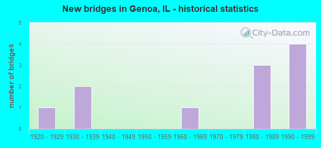
- New bridges - historical statistics
- 11920-1929
- 21930-1939
- 11960-1969
- 31980-1989
- 41990-1999

- Reconstructed bridges - Historical Statistics
- 11980-1989
- 01990-1999
- 22000-2009


- Bridge Condition - Deck
- 57.1%Good
- 28.6%Satisfactory
- 14.3%Fair

- Bridge Condition - Superstructure
- 14.3%Very good
- 57.1%Good
- 14.3%Satisfactory
- 14.3%Fair

- Bridge Condition - Substructure
- 42.9%Good
- 57.1%Satisfactory

- Bridge Condition - Channel
- 12.5%Very good
- 50.0%Good
- 25.0%Satisfactory
- 12.5%Fair
Find on map >> Show street view
Structure Number: 190005, Location: 0.7 MI S JCT ILL 72 (Lat: 42.085731, Lng: -88.684503), Route carried "on" structure: State highway 23, Year Built: 1925, Year Reconstructed: 2006, Status: Open, Structure Length: 4.35m (14.27ft), Average Daily Traffic: 4,750 (year 2021), Truck Traffic: 8%, Average Future Daily Traffic: 6,929 (year 2032), Design Load: HS 20, Features Intersected: CC & PAC. RR
Minimum Vertical Clearance: 30+ m (98+ ft), Kilometerpoint: 158.049, Lanes on structure: 2, Base Highway Network: Yes, Owner: State Highway Agency, Approaching Roadway Width: 14.6m (47.9ft), Skew: 5 degrees, Material/Design: Prestressed concrete, Design/Construction: Box Beam or Girders - Multiple, Number Of Spans In Main Unit: 3, Number Of Approach Spans: 2, Length of Maximum Span: 14.1m (46.3ft), Curb-To-Curb Width: 14.6m (47.9ft), Out-to-Out Width: 14.6m (47.9ft)
Condition: Deck: Satisfactory, Superstructure: Satisfactory, Substructure: Satisfactory, Operating Rating: 89.1 metric tons, Method Used To Determine Operating Rating: Load Factor (LF) rating reported by rating factor (RF) method using MS18 loading, Inventory Rating: 62.2 metric tons, Method Used To Determine Inventory Rating: Load Factor (LF) rating reported by rating factor (RF) method using MS18 loading, Structural Evaluation: Equal to present minimum criteria, Deck Geometry: Superior to present desirable criteria, Underclear: Equal to present minimum criteria, Approach Roadway Alignment: Equal to present minimum criteria, Designated Inspection Frequency: Every 24 months, Inspection Date: March 2021, Deck Structure Type: Concrete Precast Panels, Wearing Surface/Protective System: Wearing Surface: Integral Concrete, Deck Protection: Epoxy Coated Reinforcing
Find on map >> Show street view
Structure Number: 190026, Location: W EDGE GENOA (Lat: 42.097853, Lng: -88.704206), Route carried "on" structure: State highway 72, Year Built: 1931, Year Reconstructed: 1987, Status: Open, Structure Length: 7.01m (23.00ft), Average Daily Traffic: 5,650 (year 2021), Truck Traffic: 13%, Average Future Daily Traffic: 7,230 (year 2032), Design Load: HS 20, Features Intersected: S BR KISHWAUKEE RIV.
Minimum Vertical Clearance: 30+ m (98+ ft), Kilometerpoint: 97.845, Lanes on structure: 2, Base Highway Network: Yes, Owner: State Highway Agency, Approaching Roadway Width: 11.0m (36.1ft), Material/Design: Steel continuous, Design/Construction: Stringer/Multi-beam, Number Of Spans In Main Unit: 5, Length of Maximum Span: 17.7m (58.1ft), Curb-To-Curb Width: 11.0m (36.1ft), Out-to-Out Width: 11.5m (37.7ft)
Condition: Deck: Satisfactory, Superstructure: Good, Substructure: Satisfactory, Channel: Good, Operating Rating: 56.7 metric tons, Method Used To Determine Operating Rating: Load Factor (LF) rating reported by rating factor (RF) method using MS18 loading, Inventory Rating: 34.3 metric tons, Method Used To Determine Inventory Rating: Load Factor (LF) rating reported by rating factor (RF) method using MS18 loading, Structural Evaluation: Equal to present minimum criteria, Deck Geometry: Meets minimum limits, Waterway Adequacy: Equal to present desirable criteria, Approach Roadway Alignment: Equal to present desirable criteria, Designated Inspection Frequency: Every 24 months, Inspection Date: March 2021, Deck Structure Type: Concrete Cast-file-Place, Wearing Surface/Protective System: Deck Protection: Epoxy Coated Reinforcing
Find on map >> Show street view
Structure Number: 190035, Location: 1 MI N JCT ILL 72 (Lat: 42.109861, Lng: -88.646839), Route carried "on" structure: State highway 23, Year Built: 1987, Status: Open, Structure Length: 1.22m (4.00ft), Average Daily Traffic: 3,100 (year 2021), Truck Traffic: 11%, Average Future Daily Traffic: 3,314 (year 2032), Design Load: HS 20, Features Intersected: DEER CREEK TRIB.
Minimum Vertical Clearance: 30+ m (98+ ft), Kilometerpoint: 163.843, Lanes on structure: 2, Base Highway Network: Yes, Owner: State Highway Agency, Approaching Roadway Width: 9.8m (32.2ft), Skew: 1 degrees, Material/Design: Concrete, Design/Construction: Slab, Number Of Spans In Main Unit: 1, Length of Maximum Span: 11.6m (38.1ft), Curb-To-Curb Width: 9.8m (32.2ft), Out-to-Out Width: 10.0m (32.8ft)
Condition: Deck: Fair, Superstructure: Fair, Substructure: Good, Channel: Good, Operating Rating: 63.2 metric tons, Method Used To Determine Operating Rating: Load Factor (LF) rating reported by rating factor (RF) method using MS18 loading, Inventory Rating: 37.9 metric tons, Method Used To Determine Inventory Rating: Load Factor (LF) rating reported by rating factor (RF) method using MS18 loading, Structural Evaluation: Somewhat better than minimum adequacy, Deck Geometry: Meets minimum limits, Waterway Adequacy: Equal to present desirable criteria, Approach Roadway Alignment: Equal to present desirable criteria, Designated Inspection Frequency: Every 24 months, Inspection Date: March 2021, Deck Structure Type: Concrete Cast-file-Place, Wearing Surface/Protective System: Deck Protection: Epoxy Coated Reinforcing
Find on map >> Show street view
Structure Number: 192011, Location: 0.5 MI W JCT IL 23 N (Lat: 42.095517, Lng: -88.658981), Route carried "on" structure: State highway 23, Year Built: 1987, Status: Open, Structure Length: 0.98m (3.22ft), Average Daily Traffic: 6,250 (year 2021), Truck Traffic: 11%, Average Future Daily Traffic: 7,893 (year 2032), Design Load: HS 20, Features Intersected: DEER CREEK
Minimum Vertical Clearance: 30+ m (98+ ft), Kilometerpoint: 161.284, Lanes on structure: 2, Base Highway Network: Yes, Owner: State Highway Agency, Approaching Roadway Width: 11.4m (37.4ft), Material/Design: Concrete, Design/Construction: Culvert, Number Of Spans In Main Unit: 3, Length of Maximum Span: 3.0m (9.8ft), Curb-To-Curb Width: 9.8m (32.2ft), Out-to-Out Width: 11.6m (38.1ft)
Condition: Channel: Fair, Culverts: Good, Operating Rating: 58.0 metric tons, Method Used To Determine Operating Rating: Load Factor (LF) rating reported by rating factor (RF) method using MS18 loading, Inventory Rating: 34.7 metric tons, Method Used To Determine Inventory Rating: Load Factor (LF) rating reported by rating factor (RF) method using MS18 loading, Structural Evaluation: Better than present minimum criteria, Deck Geometry: Meets minimum limits, Waterway Adequacy: Equal to present desirable criteria, Approach Roadway Alignment: Equal to present desirable criteria, Designated Inspection Frequency: Every 48 months, Inspection Date: March 2019
Find on map >> Show street view
Structure Number: 19305, Location: 3315N 1170E (Lat: 42.111569, Lng: -88.721761), Route carried "on" structure: County highway , Year Built: 1998, Status: Open, Structure Length: 2.64m (8.66ft), Average Daily Traffic: 3,000 (year 2021), Truck Traffic: 7%, Average Future Daily Traffic: 4,037 (year 2032), Design Load: HS 20, Features Intersected: DEER CREEK, Facility Carried by Structure: GENOA ROAD
Minimum Vertical Clearance: 30+ m (98+ ft), Kilometerpoint: 6.051, Lanes on structure: 2, Base Highway Network: Yes, Owner: County Highway Agency, Approaching Roadway Width: 9.8m (32.2ft), Material/Design: Prestressed concrete, Design/Construction: Stringer/Multi-beam, Number Of Spans In Main Unit: 1, Length of Maximum Span: 25.3m (83.0ft), Curb-To-Curb Width: 12.2m (40.0ft), Out-to-Out Width: 12.2m (40.0ft)
Condition: Deck: Good, Superstructure: Very good, Substructure: Satisfactory, Channel: Good, Operating Rating: 44.1 metric tons, Method Used To Determine Operating Rating: Assigned rating based on Load Factor Design (LFD) reported by rating factor (RF) using MS18 loading, Inventory Rating: 32.4 metric tons, Method Used To Determine Inventory Rating: Assigned rating based on Load Factor Design (LFD) reported by rating factor (RF) using MS18 loading, Structural Evaluation: Equal to present minimum criteria, Deck Geometry: Equal to present minimum criteria, Waterway Adequacy: Superior to present desirable criteria, Approach Roadway Alignment: Equal to present desirable criteria, Designated Inspection Frequency: Every 24 months, Inspection Date: March 2020, Deck Structure Type: Concrete Cast-file-Place, Wearing Surface/Protective System: Membrane: Built-up, Deck Protection: Bituminous
Find on map >> Show street view
Structure Number: 193053, Location: 3310N 1310E (Lat: 42.111181, Lng: -88.695575), Route carried "on" structure: County highway , Year Built: 1999, Status: Open, Structure Length: 1.66m (5.45ft), Average Daily Traffic: 1,300 (year 2021), Truck Traffic: 46%, Average Future Daily Traffic: 1,747 (year 2032), Design Load: HS 20, Features Intersected: DEER CREEK, Facility Carried by Structure: NORTH STATE ROAD
Minimum Vertical Clearance: 30+ m (98+ ft), Kilometerpoint: 4.731, Lanes on structure: 2, Owner: County Highway Agency, Approaching Roadway Width: 6.7m (22.0ft), Skew: 1 degrees, Material/Design: Prestressed concrete, Design/Construction: Box Beam or Girders - Multiple, Number Of Spans In Main Unit: 1, Length of Maximum Span: 15.8m (51.8ft), Curb-To-Curb Width: 9.8m (32.2ft), Out-to-Out Width: 9.8m (32.2ft)
Condition: Deck: Good, Superstructure: Good, Substructure: Satisfactory, Channel: Very good, Operating Rating: 44.1 metric tons, Method Used To Determine Operating Rating: Assigned rating based on Load Factor Design (LFD) reported by rating factor (RF) using MS18 loading, Inventory Rating: 32.4 metric tons, Method Used To Determine Inventory Rating: Assigned rating based on Load Factor Design (LFD) reported by rating factor (RF) using MS18 loading, Structural Evaluation: Equal to present minimum criteria, Deck Geometry: Somewhat better than minimum adequacy, Waterway Adequacy: Equal to present desirable criteria, Approach Roadway Alignment: Equal to present desirable criteria, Designated Inspection Frequency: Every 24 months, Inspection Date: Febuary 2020, Deck Structure Type: Concrete Precast Panels, Wearing Surface/Protective System: Wearing Surface: Bituminous, Membrane: Built-up, Deck Protection: Other
Find on map >> Show street view
Structure Number: 194209, Location: 3100N 1420E (Lat: 42.080969, Lng: -88.675950), Route carried "on" structure: County highway , Year Built: 1989, Status: Open, Structure Length: 5.77m (18.93ft), Average Daily Traffic: 1,100 (year 2021), Truck Traffic: 40%, Average Future Daily Traffic: 1,687 (year 2032), Design Load: HS 20, Features Intersected: CN/IC RR, Facility Carried by Structure: DERBYLINE RD (TR 5
Minimum Vertical Clearance: 30+ m (98+ ft), Kilometerpoint: 0.740, Lanes on structure: 2, Owner: Town or Township Highway Agency, Approaching Roadway Width: 9.1m (29.9ft), Skew: 5 degrees, Material/Design: Steel continuous, Design/Construction: Stringer/Multi-beam, Number Of Spans In Main Unit: 3, Length of Maximum Span: 20.9m (68.6ft), Curb-To-Curb Width: 8.5m (27.9ft), Out-to-Out Width: 8.5m (27.9ft)
Condition: Deck: Good, Superstructure: Good, Substructure: Good, Operating Rating: 44.4 metric tons, Method Used To Determine Operating Rating: Assigned rating based on Load Factor Design (LFD) reported by rating factor (RF) using MS18 loading, Inventory Rating: 32.4 metric tons, Method Used To Determine Inventory Rating: Assigned rating based on Load Factor Design (LFD) reported by rating factor (RF) using MS18 loading, Structural Evaluation: Better than present minimum criteria, Deck Geometry: Somewhat better than minimum adequacy, Underclear: Equal to present minimum criteria, Approach Roadway Alignment: Equal to present minimum criteria, Designated Inspection Frequency: Every 48 months, Inspection Date: April 2018, Deck Structure Type: Concrete Cast-file-Place, Wearing Surface/Protective System: Deck Protection: Epoxy Coated Reinforcing
Find on map >> Show street view
Structure Number: 194211, Location: 3350N , 1390E (Lat: 42.117211, Lng: -88.683217), Route carried "on" structure: County highway , Year Built: 1996, Status: Open, Structure Length: 0.66m (2.17ft), Average Daily Traffic: 150 (year 2021), Truck Traffic: 55%, Average Future Daily Traffic: 603 (year 2032), Design Load: HS 20, Features Intersected: BR. OF DEER CREEK, Facility Carried by Structure: ASH RD
Minimum Vertical Clearance: 30+ m (98+ ft), Kilometerpoint: 1.127, Lanes on structure: 2, Owner: Town or Township Highway Agency, Approaching Roadway Width: 6.7m (22.0ft), Material/Design: Steel, Design/Construction: Culvert, Number Of Spans In Main Unit: 2, Length of Maximum Span: 2.8m (9.2ft)
Condition: Channel: Good, Culverts: Good, Operating Rating: 44.1 metric tons, Method Used To Determine Operating Rating: Assigned rating based on Load Factor Design (LFD) reported by rating factor (RF) using MS18 loading, Inventory Rating: 32.4 metric tons, Method Used To Determine Inventory Rating: Assigned rating based on Load Factor Design (LFD) reported by rating factor (RF) using MS18 loading, Structural Evaluation: Better than present minimum criteria, Waterway Adequacy: Better than present minimum criteria, Approach Roadway Alignment: Equal to present desirable criteria, Designated Inspection Frequency: Every 24 months, Inspection Date: January 2020
Find on map >> Show street view
Structure Number: 1945, Location: 3000N 1240E (Lat: 42.066461, Lng: -88.708575), Route carried "on" structure: County highway , Year Built: 1965, Year Reconstructed: 2013, Status: Open, Structure Length: 5.62m (18.44ft), Average Daily Traffic: 1,550 (year 2021), Truck Traffic: 48%, Average Future Daily Traffic: 1,928 (year 2032), Design Load: HS 20, Features Intersected: S BR KISHWAUKEE RV, Facility Carried by Structure: BASE LINE RD
Minimum Vertical Clearance: 30+ m (98+ ft), Kilometerpoint: 12.295, Lanes on structure: 2, Owner: Town or Township Highway Agency, Approaching Roadway Width: 9.1m (29.9ft), Skew: 3 degrees, Material/Design: Steel continuous, Design/Construction: Stringer/Multi-beam, Number Of Spans In Main Unit: 3, Length of Maximum Span: 20.3m (66.6ft), Curb-To-Curb Width: 9.1m (29.9ft), Out-to-Out Width: 9.1m (29.9ft)
Condition: Deck: Good, Superstructure: Good, Substructure: Good, Channel: Satisfactory, Operating Rating: 51.2 metric tons, Method Used To Determine Operating Rating: Load Factor (LF) rating reported by rating factor (RF) method using MS18 loading, Inventory Rating: 30.8 metric tons, Method Used To Determine Inventory Rating: Load Factor (LF) rating reported by rating factor (RF) method using MS18 loading, Structural Evaluation: Better than present minimum criteria, Deck Geometry: Somewhat better than minimum adequacy, Waterway Adequacy: Superior to present desirable criteria, Approach Roadway Alignment: Equal to present desirable criteria, Designated Inspection Frequency: Every 48 months, Inspection Date: October 2019, Deck Structure Type: Concrete Cast-file-Place, Wearing Surface/Protective System: Deck Protection: Epoxy Coated Reinforcing
Find on map >> Show street view
Structure Number: 194505, Location: 3000N 1365E (Lat: 42.066483, Lng: -88.689000), Route carried "on" structure: County highway , Year Built: 1991, Status: Open, Structure Length: 0.91m (2.99ft), Average Daily Traffic: 1,850 (year 2021), Truck Traffic: 50%, Average Future Daily Traffic: 2,410 (year 2032), Design Load: HS 20, Features Intersected: BR S BR KISHWAUKE RV, Facility Carried by Structure: BASELINE ROAD
Minimum Vertical Clearance: 30+ m (98+ ft), Kilometerpoint: 13.953, Lanes on structure: 2, Owner: Town or Township Highway Agency, Approaching Roadway Width: 9.1m (29.9ft), Skew: 3 degrees, Material/Design: Concrete, Design/Construction: Culvert, Number Of Spans In Main Unit: 2, Length of Maximum Span: 4.2m (13.8ft)
Condition: Channel: Satisfactory, Culverts: Good, Operating Rating: 44.4 metric tons, Method Used To Determine Operating Rating: Assigned rating based on Load Factor Design (LFD) reported by rating factor (RF) using MS18 loading, Inventory Rating: 32.4 metric tons, Method Used To Determine Inventory Rating: Assigned rating based on Load Factor Design (LFD) reported by rating factor (RF) using MS18 loading, Structural Evaluation: Better than present minimum criteria, Waterway Adequacy: Better than present minimum criteria, Approach Roadway Alignment: Equal to present desirable criteria, Designated Inspection Frequency: Every 48 months, Inspection Date: April 2018
Find on map >> Show street view
Structure Number: 199901, Location: IN GENOA (Lat: 42.098125, Lng: -88.701394), Route carried "under" structure: State highway 72, Year Built: 1932, Structure Length: 0. m, Average Daily Traffic: 5,650 (year 2021), Truck Traffic: 13%, Features Intersected: ILL 72 FAP 553, Facility Carried by Structure: IC RR
Minimum Vertical Clearance: 6.17m (20.24ft), Kilometerpoint: 98.135, Lanes under structure: 2, Material/Design: Steel, Design/Construction: Girder and Floorbeam System, Length of Maximum Span: 18.9m (62.0ft)