Bridge Statistics for Geneva, Wisconsin (WI)
Condition, Traffic, Stress, Structural Evaluation, Project Costs
- National Bridge Inventory (NBI) Statistics
- 26Number of bridges
- 220ft / 67.1mTotal length
- $897,000Total costs
- 264,744Total average daily traffic
- 23,034Total average daily truck traffic
- National Bridge Inventory (NBI) Registered Bridges for Geneva
- No street view available for this location
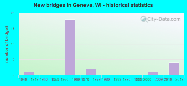
- New bridges - historical statistics
- 11940-1949
- 181960-1969
- 21970-1979
- 12000-2009
- 42010-2019


- Bridge Condition - Deck
- 36.4%Good
- 27.3%Satisfactory
- 36.4%Fair

- Bridge Condition - Superstructure
- 27.3%Good
- 54.5%Satisfactory
- 9.1%Fair
- 9.1%Poor

- Bridge Condition - Substructure
- 9.1%Very good
- 18.2%Good
- 72.7%Satisfactory

- Bridge Condition - Channel
- 44.4%Very good
- 33.3%Good
- 11.1%Satisfactory
- 11.1%Fair

- Bridge Condition - Culverts
- 42.9%Good
- 57.1%Satisfactory
Find on map >> Show street view
Structure Number: B64003, Location: 0.5 MI E JCT STH 120 (Lat: 42.603167, Lng: -88.416339), Route carried "on" structure: US 12, Year Built: 1967, Status: Open, Structure Length: 1.01m (3.31ft), Average Daily Traffic: 22,200 (year 2018), Truck Traffic: 13%, Average Future Daily Traffic: 14,500 (year 2039), Design Load: HS 20, Features Intersected: WHITE RIVER
Minimum Vertical Clearance: 30+ m (98+ ft), Kilometerpoint: 0.000, Lanes on structure: 4, Base Highway Network: Yes, Owner: State Highway Agency, Approaching Roadway Width: 25.6m (84.0ft), Skew: 1 degrees, Material/Design: Concrete continuous, Design/Construction: Culvert, Number Of Spans In Main Unit: 3, Length of Maximum Span: 3.0m (9.8ft)
Condition: Channel: Very good, Culverts: Good, Operating Rating: 53.9 metric tons, Method Used To Determine Operating Rating: Field evaluation and documented engineering judgment, Inventory Rating: 32.4 metric tons, Method Used To Determine Inventory Rating: Field evaluation and documented engineering judgment, Structural Evaluation: Better than present minimum criteria, Waterway Adequacy: Equal to present desirable criteria, Approach Roadway Alignment: Equal to present desirable criteria, Designated Inspection Frequency: Every 24 months, Inspection Date: July 2020, Deck Structure Type: Concrete Cast-file-Place, Wearing Surface/Protective System: Wearing Surface: Monolithic Concrete
Find on map >> Show street view
Structure Number: B640034, Location: 5.0 MI E JCT IH 43 MILE P (Lat: 42.615322, Lng: -88.444111), Route carried "on" structure: US 12, Year Built: 1967, Status: Open, Structure Length: 1.63m (5.35ft), Average Daily Traffic: 21,700 (year 2018), Truck Traffic: 8%, Average Future Daily Traffic: 15,530 (year 2039), Design Load: HS 20, Features Intersected: COMO CREEK
Minimum Vertical Clearance: 30+ m (98+ ft), Kilometerpoint: 0.000, Lanes on structure: 4, Base Highway Network: Yes, Owner: State Highway Agency, Approaching Roadway Width: 25.6m (84.0ft), Skew: 4 degrees, Material/Design: Concrete continuous, Design/Construction: Culvert, Number Of Spans In Main Unit: 3, Length of Maximum Span: 3.7m (12.1ft)
Condition: Channel: Very good, Culverts: Satisfactory, Operating Rating: 53.9 metric tons, Method Used To Determine Operating Rating: Field evaluation and documented engineering judgment, Inventory Rating: 32.4 metric tons, Method Used To Determine Inventory Rating: Field evaluation and documented engineering judgment, Structural Evaluation: Equal to present minimum criteria, Waterway Adequacy: Equal to present desirable criteria, Approach Roadway Alignment: Equal to present desirable criteria, Designated Inspection Frequency: Every 24 months, Inspection Date: July 2020, Deck Structure Type: Concrete Cast-file-Place, Wearing Surface/Protective System: Wearing Surface: Monolithic Concrete
Find on map >> Show street view
Structure Number: B640035, Location: 5.8 MI E JCT IH 43 (Lat: 42.615225, Lng: -88.447200), Route carried "on" structure: US 12, Year Built: 1967, Status: Open, Structure Length: 4.37m (14.34ft), Average Daily Traffic: 9,400 (year 2018), Truck Traffic: 8%, Average Future Daily Traffic: 11,280 (year 2038), Design Load: HS 20, Features Intersected: CTH NN
Minimum Vertical Clearance: 30+ m (98+ ft), Kilometerpoint: 0.000, Lanes on structure: 2, Lanes under structure: 2, Base Highway Network: Yes, Owner: State Highway Agency, Approaching Roadway Width: 11.9m (39.0ft), Skew: 4 degrees, Material/Design: Steel continuous, Design/Construction: Stringer/Multi-beam, Number Of Spans In Main Unit: 3, Length of Maximum Span: 16.5m (54.1ft), Curb-To-Curb Width: 11.9m (39.0ft), Out-to-Out Width: 12.8m (42.0ft)
Condition: Deck: Fair, Superstructure: Poor, Substructure: Satisfactory, Operating Rating: 45.7 metric tons, Method Used To Determine Operating Rating: Load Factor (LF), Inventory Rating: 27.5 metric tons, Method Used To Determine Inventory Rating: Load Factor (LF), Structural Evaluation: Meets minimum limits, Deck Geometry: Better than present minimum criteria, Underclear: Meets minimum limits, Approach Roadway Alignment: Equal to present desirable criteria, Length Of Structure Improvement: 4.82m (15.81ft), Designated Inspection Frequency: Every 12 months, Inspection Date: April 2021, Bridge Improvement Cost: $598,000, Roadway Improvement Cost: $59,000, Total Project Cost: $897,000 ( Estimate for 2021), Deck Structure Type: Concrete Cast-file-Place, Wearing Surface/Protective System: Wearing Surface: Low Slump Concrete
Find on map >> Show street view
Structure Number: B640036, Location: 1.5 MI W JCT STH 120 (Lat: 42.615575, Lng: -88.447058), Route carried "on" structure: US 12, Year Built: 1967, Status: Open, Structure Length: 4.37m (14.34ft), Average Daily Traffic: 9,400 (year 2018), Truck Traffic: 8%, Average Future Daily Traffic: 11,280 (year 2038), Design Load: HS 20, Features Intersected: CTH NN
Minimum Vertical Clearance: 30+ m (98+ ft), Kilometerpoint: 0.000, Lanes on structure: 2, Lanes under structure: 2, Base Highway Network: Yes, Owner: State Highway Agency, Approaching Roadway Width: 11.9m (39.0ft), Skew: 4 degrees, Material/Design: Steel continuous, Design/Construction: Stringer/Multi-beam, Number Of Spans In Main Unit: 3, Length of Maximum Span: 16.5m (54.1ft), Curb-To-Curb Width: 11.9m (39.0ft), Out-to-Out Width: 12.8m (42.0ft)
Condition: Deck: Fair, Superstructure: Satisfactory, Substructure: Satisfactory, Operating Rating: 44.1 metric tons, Method Used To Determine Operating Rating: Load Factor (LF), Inventory Rating: 25.9 metric tons, Method Used To Determine Inventory Rating: Load Factor (LF), Structural Evaluation: Equal to present minimum criteria, Deck Geometry: Better than present minimum criteria, Underclear: Meets minimum limits, Approach Roadway Alignment: Equal to present desirable criteria, Designated Inspection Frequency: Every 24 months, Inspection Date: April 2021, Deck Structure Type: Concrete Cast-file-Place, Wearing Surface/Protective System: Wearing Surface: Low Slump Concrete
Find on map >> Show street view
Structure Number: B640037, Location: 4.0 MI E JCT IH 43 MILE P (Lat: 42.617053, Lng: -88.457344), Route carried "on" structure: US 12, Year Built: 1967, Status: Open, Structure Length: 0.98m (3.22ft), Average Daily Traffic: 10,850 (year 2018), Truck Traffic: 8%, Average Future Daily Traffic: 7,765 (year 2039), Design Load: HS 20, Features Intersected: BR COMO CREEK
Minimum Vertical Clearance: 30+ m (98+ ft), Kilometerpoint: 0.000, Lanes on structure: 2, Base Highway Network: Yes, Owner: State Highway Agency, Approaching Roadway Width: 12.8m (42.0ft), Skew: 3 degrees, Material/Design: Concrete continuous, Design/Construction: Culvert, Number Of Spans In Main Unit: 3, Length of Maximum Span: 3.0m (9.8ft)
Condition: Channel: Good, Culverts: Good, Operating Rating: 53.9 metric tons, Method Used To Determine Operating Rating: Field evaluation and documented engineering judgment, Inventory Rating: 32.4 metric tons, Method Used To Determine Inventory Rating: Field evaluation and documented engineering judgment, Structural Evaluation: Better than present minimum criteria, Waterway Adequacy: Equal to present desirable criteria, Approach Roadway Alignment: Equal to present desirable criteria, Designated Inspection Frequency: Every 24 months, Inspection Date: July 2020, Deck Structure Type: Concrete Cast-file-Place, Wearing Surface/Protective System: Wearing Surface: Monolithic Concrete
Find on map >> Show street view
Structure Number: B640038, Location: 2.0 MI W JCT STH 120 (Lat: 42.617922, Lng: -88.457464), Route carried "on" structure: US 12, Year Built: 1967, Status: Open, Structure Length: 0.98m (3.22ft), Average Daily Traffic: 10,850 (year 2018), Truck Traffic: 8%, Average Future Daily Traffic: 7,765 (year 2039), Design Load: HS 20, Features Intersected: BR COMO CREEK
Minimum Vertical Clearance: 30+ m (98+ ft), Kilometerpoint: 0.000, Lanes on structure: 2, Base Highway Network: Yes, Owner: State Highway Agency, Approaching Roadway Width: 11.9m (39.0ft), Skew: 4 degrees, Material/Design: Concrete continuous, Design/Construction: Culvert, Number Of Spans In Main Unit: 3, Length of Maximum Span: 3.0m (9.8ft)
Condition: Channel: Good, Culverts: Satisfactory, Operating Rating: 53.9 metric tons, Method Used To Determine Operating Rating: Field evaluation and documented engineering judgment, Inventory Rating: 32.4 metric tons, Method Used To Determine Inventory Rating: Field evaluation and documented engineering judgment, Structural Evaluation: Equal to present minimum criteria, Waterway Adequacy: Equal to present desirable criteria, Approach Roadway Alignment: Equal to present desirable criteria, Designated Inspection Frequency: Every 24 months, Inspection Date: July 2020, Deck Structure Type: Concrete Cast-file-Place, Wearing Surface/Protective System: Wearing Surface: Monolithic Concrete
Find on map >> Show street view
Structure Number: B640039, Location: 0.9M W JCT CTH NN (Lat: 42.628956, Lng: -88.471219), Route carried "on" structure: City street , Year Built: 1968, Status: Open, Structure Length: 5.71m (18.73ft), Average Daily Traffic: 820 (year 2019), Average Future Daily Traffic: 820 (year 2040), Design Load: H 15, Features Intersected: USH 12, Facility Carried by Structure: LRD SPRINGFIELD RD
Minimum Vertical Clearance: 30+ m (98+ ft), Kilometerpoint: 0.000, Lanes on structure: 2, Lanes under structure: 4, Owner: State Highway Agency, Approaching Roadway Width: 9.1m (29.9ft), Skew: 1 degrees, Material/Design: Steel continuous, Design/Construction: Stringer/Multi-beam, Number Of Spans In Main Unit: 2, Length of Maximum Span: 27.7m (90.9ft), Curb-To-Curb Width: 8.2m (26.9ft), Out-to-Out Width: 9.3m (30.5ft)
Condition: Deck: Fair, Superstructure: Satisfactory, Substructure: Satisfactory, Operating Rating: 44.1 metric tons, Method Used To Determine Operating Rating: Load Factor (LF), Inventory Rating: 21.1 metric tons, Method Used To Determine Inventory Rating: Load Factor (LF), Structural Evaluation: Somewhat better than minimum adequacy, Deck Geometry: Somewhat better than minimum adequacy, Underclear: Equal to present minimum criteria, Approach Roadway Alignment: Equal to present desirable criteria, Designated Inspection Frequency: Every 24 months, Inspection Date: April 2021, Deck Structure Type: Concrete Cast-file-Place, Wearing Surface/Protective System: Wearing Surface: Bituminous
Find on map >> Show street view
Structure Number: B640041, Location: 1.7M E JCT IH 43 TO N (Lat: 42.652742, Lng: -88.507475), Route carried "on" structure: US 12, Year Built: 1968, Year Reconstructed: 2001, Status: Open, Structure Length: 4.27m (14.01ft), Average Daily Traffic: 9,400 (year 2018), Truck Traffic: 13%, Average Future Daily Traffic: 11,280 (year 2038), Design Load: HS 20, Features Intersected: LRD MACLEAN RD
Minimum Vertical Clearance: 30+ m (98+ ft), Kilometerpoint: 0.000, Lanes on structure: 2, Lanes under structure: 2, Base Highway Network: Yes, Owner: State Highway Agency, Approaching Roadway Width: 12.8m (42.0ft), Skew: 4 degrees, Material/Design: Steel continuous, Design/Construction: Stringer/Multi-beam, Number Of Spans In Main Unit: 3, Length of Maximum Span: 15.1m (49.5ft), Curb-To-Curb Width: 12.2m (40.0ft), Out-to-Out Width: 13.1m (43.0ft)
Condition: Deck: Good, Superstructure: Satisfactory, Substructure: Satisfactory, Operating Rating: 35.9 metric tons, Method Used To Determine Operating Rating: Load Factor (LF), Inventory Rating: 22.7 metric tons, Method Used To Determine Inventory Rating: Load Factor (LF), Structural Evaluation: Somewhat better than minimum adequacy, Deck Geometry: Better than present minimum criteria, Underclear: Meets minimum limits, Approach Roadway Alignment: Equal to present desirable criteria, Designated Inspection Frequency: Every 24 months, Inspection Date: April 2021, Deck Structure Type: Concrete Cast-file-Place, Wearing Surface/Protective System: Wearing Surface: Epoxy Overlay, Deck Protection: Epoxy Coated Reinforcing
Find on map >> Show street view
Structure Number: B640042, Location: 5.6M W JCT STH 120 TO N (Lat: 42.652247, Lng: -88.506667), Route carried "on" structure: US 12, Year Built: 1968, Year Reconstructed: 2001, Status: Open, Structure Length: 4.27m (14.01ft), Average Daily Traffic: 9,400 (year 2018), Truck Traffic: 13%, Average Future Daily Traffic: 11,280 (year 2038), Design Load: HS 20, Features Intersected: LRD MACLEAN RD
Minimum Vertical Clearance: 30+ m (98+ ft), Kilometerpoint: 0.000, Lanes on structure: 2, Lanes under structure: 2, Base Highway Network: Yes, Owner: State Highway Agency, Approaching Roadway Width: 12.8m (42.0ft), Skew: 4 degrees, Material/Design: Steel continuous, Design/Construction: Stringer/Multi-beam, Number Of Spans In Main Unit: 3, Length of Maximum Span: 15.1m (49.5ft), Curb-To-Curb Width: 12.1m (39.7ft), Out-to-Out Width: 13.0m (42.7ft)
Condition: Deck: Satisfactory, Superstructure: Satisfactory, Substructure: Satisfactory, Operating Rating: 39.2 metric tons, Method Used To Determine Operating Rating: Load Factor (LF), Inventory Rating: 22.7 metric tons, Method Used To Determine Inventory Rating: Load Factor (LF), Structural Evaluation: Somewhat better than minimum adequacy, Deck Geometry: Better than present minimum criteria, Underclear: Meets minimum limits, Approach Roadway Alignment: Equal to present desirable criteria, Designated Inspection Frequency: Every 24 months, Inspection Date: April 2021, Deck Structure Type: Concrete Cast-file-Place, Wearing Surface/Protective System: Wearing Surface: Epoxy Overlay, Deck Protection: Epoxy Coated Reinforcing
Find on map >> Show street view
Structure Number: B640043, Location: 0.9 MI E JCT IH 43/USH 12 (Lat: 42.656853, Lng: -88.509936), Route carried "on" structure: US 12, Year Built: 1968, Year Reconstructed: 2001, Status: Open, Structure Length: 5.82m (19.09ft), Average Daily Traffic: 9,400 (year 2018), Truck Traffic: 13%, Average Future Daily Traffic: 14,500 (year 2040), Design Load: HS 20, Features Intersected: BICYCLE TRAIL
Minimum Vertical Clearance: 30+ m (98+ ft), Kilometerpoint: 0.000, Lanes on structure: 2, Base Highway Network: Yes, Owner: State Highway Agency, Approaching Roadway Width: 12.2m (40.0ft), Skew: 4 degrees, Material/Design: Prestressed concrete continuous, Design/Construction: Stringer/Multi-beam, Number Of Spans In Main Unit: 3, Length of Maximum Span: 19.2m (63.0ft), Curb-To-Curb Width: 12.2m (40.0ft), Out-to-Out Width: 13.0m (42.7ft)
Condition: Deck: Satisfactory, Superstructure: Satisfactory, Substructure: Satisfactory, Operating Rating: 67.0 metric tons, Method Used To Determine Operating Rating: Load Factor (LF), Inventory Rating: 30.8 metric tons, Method Used To Determine Inventory Rating: Load Factor (LF), Structural Evaluation: Equal to present minimum criteria, Deck Geometry: Better than present minimum criteria, Underclear: Superior to present desirable criteria, Approach Roadway Alignment: Equal to present desirable criteria, Designated Inspection Frequency: Every 24 months, Inspection Date: March 2021, Deck Structure Type: Concrete Cast-file-Place, Wearing Surface/Protective System: Wearing Surface: Monolithic Concrete, Deck Protection: Epoxy Coated Reinforcing
Find on map >> Show street view
Structure Number: B640044, Location: 5.9 MI W JCT STH 120 (Lat: 42.656200, Lng: -88.509022), Route carried "on" structure: US 12, Year Built: 1968, Year Reconstructed: 2001, Status: Open, Structure Length: 5.82m (19.09ft), Average Daily Traffic: 9,400 (year 2018), Truck Traffic: 13%, Average Future Daily Traffic: 11,280 (year 2038), Design Load: HS 20, Features Intersected: BICYCLE TRAIL
Minimum Vertical Clearance: 30+ m (98+ ft), Kilometerpoint: 0.000, Lanes on structure: 2, Base Highway Network: Yes, Owner: State Highway Agency, Approaching Roadway Width: 12.2m (40.0ft), Skew: 4 degrees, Material/Design: Prestressed concrete continuous, Design/Construction: Stringer/Multi-beam, Number Of Spans In Main Unit: 3, Length of Maximum Span: 19.2m (63.0ft), Curb-To-Curb Width: 12.2m (40.0ft), Out-to-Out Width: 13.0m (42.7ft)
Condition: Deck: Satisfactory, Superstructure: Satisfactory, Substructure: Satisfactory, Operating Rating: 67.0 metric tons, Method Used To Determine Operating Rating: Load Factor (LF), Inventory Rating: 30.8 metric tons, Method Used To Determine Inventory Rating: Load Factor (LF), Structural Evaluation: Equal to present minimum criteria, Deck Geometry: Better than present minimum criteria, Underclear: Better than present minimum criteria, Approach Roadway Alignment: Equal to present desirable criteria, Designated Inspection Frequency: Every 24 months, Inspection Date: March 2021, Deck Structure Type: Concrete Cast-file-Place, Wearing Surface/Protective System: Wearing Surface: Monolithic Concrete, Deck Protection: Epoxy Coated Reinforcing
Find on map >> Show street view
Structure Number: B640061, Location: 2.6 MI E JCT IH 43 (Lat: 42.642194, Lng: -88.494900), Route carried "on" structure: US 12, Year Built: 1968, Status: Open, Structure Length: 1.10m (3.61ft), Average Daily Traffic: 18,800 (year 2018), Truck Traffic: 13%, Average Future Daily Traffic: 14,500 (year 2039), Design Load: HS 20, Features Intersected: JACKSON CREEK
Minimum Vertical Clearance: 30+ m (98+ ft), Kilometerpoint: 0.000, Lanes on structure: 4, Base Highway Network: Yes, Owner: State Highway Agency, Approaching Roadway Width: 25.6m (84.0ft), Skew: 1 degrees, Material/Design: Concrete continuous, Design/Construction: Culvert, Number Of Spans In Main Unit: 3, Length of Maximum Span: 3.4m (11.2ft)
Condition: Channel: Good, Culverts: Good, Operating Rating: 53.9 metric tons, Method Used To Determine Operating Rating: Field evaluation and documented engineering judgment, Inventory Rating: 32.4 metric tons, Method Used To Determine Inventory Rating: Field evaluation and documented engineering judgment, Structural Evaluation: Better than present minimum criteria, Waterway Adequacy: Equal to present desirable criteria, Approach Roadway Alignment: Equal to present desirable criteria, Designated Inspection Frequency: Every 24 months, Inspection Date: July 2020, Deck Structure Type: Concrete Cast-file-Place, Wearing Surface/Protective System: Wearing Surface: Monolithic Concrete
Find on map >> Show street view
Structure Number: B64014, Location: 0.5 MI S JCT STH 67 (Lat: 42.651267, Lng: -88.550358), Route carried "on" structure: Interstate 43, Year Built: 1976, Status: Open, Structure Length: 1.56m (5.12ft), Average Daily Traffic: 21,700 (year 2019), Truck Traffic: 16%, Average Future Daily Traffic: 27,970 (year 2039), Design Load: HS 20, Features Intersected: BR JACKSON CREEK
Minimum Vertical Clearance: 30+ m (98+ ft), Kilometerpoint: 0.000, Lanes on structure: 4, Base Highway Network: Yes, Owner: State Highway Agency, Approaching Roadway Width: 25.6m (84.0ft), Skew: 5 degrees, Material/Design: Concrete continuous, Design/Construction: Culvert, Number Of Spans In Main Unit: 3, Length of Maximum Span: 3.0m (9.8ft)
Condition: Channel: Satisfactory, Culverts: Satisfactory, Operating Rating: 53.9 metric tons, Method Used To Determine Operating Rating: Field evaluation and documented engineering judgment, Inventory Rating: 32.4 metric tons, Method Used To Determine Inventory Rating: Field evaluation and documented engineering judgment, Structural Evaluation: Equal to present minimum criteria, Waterway Adequacy: Equal to present desirable criteria, Approach Roadway Alignment: Equal to present desirable criteria, Designated Inspection Frequency: Every 24 months, Inspection Date: August 2020, Deck Structure Type: Concrete Cast-file-Place, Wearing Surface/Protective System: Wearing Surface: Monolithic Concrete
Find on map >> Show street view
Structure Number: B640148, Location: 0.2M S JCT CTH H (Lat: 42.641306, Lng: -88.521864), Route carried "on" structure: City street , Year Built: 1979, Status: Open, Structure Length: 1.04m (3.41ft), Average Daily Traffic: 274 (year 2019), Average Future Daily Traffic: 301 (year 2039), Design Load: H 20, Features Intersected: JACKSON CREEK, Facility Carried by Structure: LRD PETRIE RD
Minimum Vertical Clearance: 30+ m (98+ ft), Kilometerpoint: 0.000, Lanes on structure: 2, Owner: Town or Township Highway Agency, Approaching Roadway Width: 7.9m (25.9ft), Material/Design: Concrete, Design/Construction: Slab, Number Of Spans In Main Unit: 1, Length of Maximum Span: 9.6m (31.5ft), Curb-To-Curb Width: 7.9m (25.9ft), Out-to-Out Width: 8.5m (27.9ft)
Condition: Deck: Fair, Superstructure: Fair, Substructure: Satisfactory, Channel: Very good, Operating Rating: 50.6 metric tons, Method Used To Determine Operating Rating: Load Factor (LF), Inventory Rating: 29.2 metric tons, Method Used To Determine Inventory Rating: Load Factor (LF), Structural Evaluation: Somewhat better than minimum adequacy, Deck Geometry: Somewhat better than minimum adequacy, Waterway Adequacy: Equal to present desirable criteria, Approach Roadway Alignment: Equal to present desirable criteria, Designated Inspection Frequency: Every 24 months, Inspection Date: August 2020, Deck Structure Type: Concrete Cast-file-Place, Wearing Surface/Protective System: Wearing Surface: Monolithic Concrete
Find on map >> Show street view
Structure Number: B640169, Location: 2.1S JCT CTH NN (Lat: 42.640419, Lng: -88.517858), Route carried "on" structure: County highway , Year Built: 2006, Status: Open, Structure Length: 1.54m (5.05ft), Average Daily Traffic: 4,200 (year 2018), Truck Traffic: 10%, Average Future Daily Traffic: 5,020 (year 2038), Design Load: HS 25 or greater, Features Intersected: JACKSON CREEK, Facility Carried by Structure: CTH H
Minimum Vertical Clearance: 30+ m (98+ ft), Kilometerpoint: 0.000, Lanes on structure: 2, Owner: County Highway Agency, Approaching Roadway Width: 12.2m (40.0ft), Material/Design: Concrete, Design/Construction: Slab, Number Of Spans In Main Unit: 1, Length of Maximum Span: 14.6m (47.9ft), Curb-To-Curb Width: 13.4m (44.0ft), Out-to-Out Width: 14.0m (45.9ft)
Condition: Deck: Good, Superstructure: Good, Substructure: Very good, Channel: Very good, Operating Rating: 75.1 metric tons, Method Used To Determine Operating Rating: Load Factor (LF), Inventory Rating: 45.4 metric tons, Method Used To Determine Inventory Rating: Load Factor (LF), Structural Evaluation: Better than present minimum criteria, Deck Geometry: Better than present minimum criteria, Waterway Adequacy: Equal to present desirable criteria, Approach Roadway Alignment: Equal to present desirable criteria, Designated Inspection Frequency: Every 48 months, Inspection Date: August 2020, Deck Structure Type: Concrete Cast-file-Place, Wearing Surface/Protective System: Wearing Surface: Monolithic Concrete, Deck Protection: Epoxy Coated Reinforcing
Find on map >> Show street view
Structure Number: B640185, Location: 0.2 MI E JCT CTH HH (Lat: 42.669692, Lng: -88.519100), Route carried "on" structure: County highway , Year Built: 2016, Status: Open, Structure Length: 10.79m (35.40ft), Average Daily Traffic: 3,500 (year 2018), Average Future Daily Traffic: 4,200 (year 2038), Design Load: HL 93, Features Intersected: USH 12, Facility Carried by Structure: CTH NN EB
Minimum Vertical Clearance: 30+ m (98+ ft), Kilometerpoint: 0.000, Lanes on structure: 2, Lanes under structure: 8, Owner: State Highway Agency, Approaching Roadway Width: 12.2m (40.0ft), Skew: 3 degrees, Material/Design: Prestressed concrete continuous, Design/Construction: Stringer/Multi-beam, Number Of Spans In Main Unit: 4, Length of Maximum Span: 26.8m (87.9ft), Curb-To-Curb Width: 12.2m (40.0ft), Out-to-Out Width: 13.0m (42.7ft)
Condition: Deck: Good, Superstructure: Good, Substructure: Good, Operating Rating: 51.8 metric tons, Method Used To Determine Operating Rating: Load and Resistance Factor Rating (LRFR) rating reported by rating factor(RF) method using HL-93 loadings, Inventory Rating: 39.9 metric tons, Method Used To Determine Inventory Rating: Load and Resistance Factor Rating (LRFR) rating reported by rating factor(RF) method using HL-93 loadings, Structural Evaluation: Better than present minimum criteria, Deck Geometry: Better than present minimum criteria, Underclear: Equal to present minimum criteria, Approach Roadway Alignment: Equal to present desirable criteria, Designated Inspection Frequency: Every 48 months, Inspection Date: August 2020, Deck Structure Type: Concrete Cast-file-Place, Wearing Surface/Protective System: Wearing Surface: Monolithic Concrete, Deck Protection: Epoxy Coated Reinforcing
Find on map >> Show street view
Structure Number: B640186, Location: 0.4 MI E JCT IH 43 (Lat: 42.670003, Lng: -88.518036), Route carried "on" structure: County highway , Year Built: 2016, Status: Open, Structure Length: 10.79m (35.40ft), Average Daily Traffic: 3,500 (year 2018), Average Future Daily Traffic: 4,200 (year 2038), Design Load: HL 93, Features Intersected: USH 12, Facility Carried by Structure: CTH NN WB
Minimum Vertical Clearance: 30+ m (98+ ft), Kilometerpoint: 0.000, Lanes on structure: 2, Lanes under structure: 8, Owner: State Highway Agency, Approaching Roadway Width: 15.8m (51.8ft), Skew: 3 degrees, Material/Design: Prestressed concrete continuous, Design/Construction: Stringer/Multi-beam, Number Of Spans In Main Unit: 4, Length of Maximum Span: 26.8m (87.9ft), Curb or Sidewalk Widths: Left: 3.7m (12.1ft), Right: 0.0m, Curb-To-Curb Width: 19.5m (64.0ft), Out-to-Out Width: 20.6m (67.6ft)
Condition: Deck: Good, Superstructure: Good, Substructure: Good, Operating Rating: 44.1 metric tons, Method Used To Determine Operating Rating: Load and Resistance Factor Rating (LRFR) rating reported by rating factor(RF) method using HL-93 loadings, Inventory Rating: 34.0 metric tons, Method Used To Determine Inventory Rating: Load and Resistance Factor Rating (LRFR) rating reported by rating factor(RF) method using HL-93 loadings, Structural Evaluation: Better than present minimum criteria, Deck Geometry: Superior to present desirable criteria, Underclear: Equal to present minimum criteria, Approach Roadway Alignment: Equal to present desirable criteria, Designated Inspection Frequency: Every 48 months, Inspection Date: August 2020, Deck Structure Type: Concrete Cast-file-Place, Wearing Surface/Protective System: Wearing Surface: Monolithic Concrete, Deck Protection: Epoxy Coated Reinforcing
Find on map >> Show street view
Structure Number: B640438, Location: 0.3M N JCT CTH NN (Lat: 42.612267, Lng: -88.454250), Route carried "on" structure: County highway , Year Built: 1941, Status: Open, Structure Length: 1.09m (3.58ft), Average Daily Traffic: 8,100 (year 2018), Average Future Daily Traffic: 9,720 (year 2038), Design Load: H 15, Features Intersected: COMO CREEK, Facility Carried by Structure: CTH H
Minimum Vertical Clearance: 30+ m (98+ ft), Kilometerpoint: 0.000, Lanes on structure: 2, Owner: County Highway Agency, Approaching Roadway Width: 11.0m (36.1ft), Skew: 6 degrees, Material/Design: Concrete continuous, Design/Construction: Culvert, Number Of Spans In Main Unit: 2, Length of Maximum Span: 2.4m (7.9ft), Curb-To-Curb Width: 11.0m (36.1ft), Out-to-Out Width: 23.3m (76.4ft)
Condition: Channel: Fair, Culverts: Satisfactory, Operating Rating: 53.9 metric tons, Method Used To Determine Operating Rating: Field evaluation and documented engineering judgment, Inventory Rating: 24.3 metric tons, Method Used To Determine Inventory Rating: Field evaluation and documented engineering judgment, Structural Evaluation: Equal to present minimum criteria, Deck Geometry: Meets minimum limits, Waterway Adequacy: Equal to present desirable criteria, Approach Roadway Alignment: Equal to present desirable criteria, Designated Inspection Frequency: Every 24 months, Underwater Inspection Frequency: Every 60 months, Inspection Date: August 2020, Underwater Inspection Date: May 2019, Deck Structure Type: Concrete Cast-file-Place, Wearing Surface/Protective System: Wearing Surface: Bituminous
Find on map >> Show street view
Structure Number: B640035, Location: 0.4M N JCT CTH H (Lat: 42.615225, Lng: -88.447200), Route carried "under" structure: County highway , Year Built: 1967, Structure Length: 0. m, Average Daily Traffic: 3,100 (year 2018), Features Intersected: CTH NN, Facility Carried by Structure: USH 12 EB
Minimum Vertical Clearance: 4.29m (14.07ft), Kilometerpoint: 0.000, Lanes on structure: 2, Lanes under structure: 2, Material/Design: Steel continuous, Design/Construction: Stringer/Multi-beam, Length of Maximum Span: 16.5m (54.1ft)
Find on map >> Show street view
Structure Number: B640036, Location: 0.4M N JCT CTH H (Lat: 42.615575, Lng: -88.447058), Route carried "under" structure: County highway , Year Built: 1967, Structure Length: 0. m, Average Daily Traffic: 3,100 (year 2018), Features Intersected: CTH NN, Facility Carried by Structure: USH 12 WB
Minimum Vertical Clearance: 4.49m (14.73ft), Kilometerpoint: 0.000, Lanes on structure: 2, Lanes under structure: 2, Material/Design: Steel continuous, Design/Construction: Stringer/Multi-beam, Length of Maximum Span: 16.5m (54.1ft)
Find on map >> Show street view
Structure Number: B640039, Location: 3.2M E JCT IH 43 TO N (Lat: 42.628956, Lng: -88.471219), Route carried "under" structure: US 12, Year Built: 1968, Structure Length: 0. m, Average Daily Traffic: 18,800 (year 2018), Truck Traffic: 8%, Features Intersected: USH 12, Facility Carried by Structure: LRD SPRINGFIELD RD
Minimum Vertical Clearance: 4.48m (14.70ft), Kilometerpoint: 0.000, Lanes on structure: 2, Lanes under structure: 4, Material/Design: Steel continuous, Design/Construction: Stringer/Multi-beam, Length of Maximum Span: 27.7m (90.9ft)
Find on map >> Show street view
Structure Number: B64004, Location: 2.2M E JCT IH 43 TO N (Lat: 42.638378, Lng: -88.486739), Route carried "under" structure: US 12, Year Built: 1968, Structure Length: 0. m, Average Daily Traffic: 18,800 (year 2018), Truck Traffic: 13%, Features Intersected: USH 12, Facility Carried by Structure: LRD COMO RD
Minimum Vertical Clearance: 4.44m (14.57ft), Kilometerpoint: 0.000, Lanes on structure: 2, Lanes under structure: 4, Material/Design: Steel continuous, Design/Construction: Stringer/Multi-beam, Length of Maximum Span: 32.9m (107.9ft)
Find on map >> Show street view
Structure Number: B640041, Location: 0.8M E JCT CTH H (Lat: 42.652742, Lng: -88.507475), Route carried "under" structure: City street , Year Built: 1968, Structure Length: 0. m, Average Daily Traffic: 225 (year 2019), Features Intersected: LRD MACLEAN RD, Facility Carried by Structure: USH 12 EB
Minimum Vertical Clearance: 4.47m (14.67ft), Kilometerpoint: 0.000, Lanes on structure: 2, Lanes under structure: 2, Material/Design: Steel continuous, Design/Construction: Stringer/Multi-beam, Length of Maximum Span: 15.1m (49.5ft)
Find on map >> Show street view
Structure Number: B640042, Location: 0.8M E JCT CTH H (Lat: 42.652247, Lng: -88.506667), Route carried "under" structure: City street , Year Built: 1968, Structure Length: 0. m, Average Daily Traffic: 225 (year 2019), Features Intersected: LRD MACLEAN RD, Facility Carried by Structure: USH 12 WB
Minimum Vertical Clearance: 4.47m (14.67ft), Kilometerpoint: 0.000, Lanes on structure: 2, Lanes under structure: 2, Material/Design: Steel continuous, Design/Construction: Stringer/Multi-beam, Length of Maximum Span: 15.1m (49.5ft)
Find on map >> Show street view
Structure Number: B640185, Location: 0.3 MI S JCT IH 43 (Lat: 42.669692, Lng: -88.519100), Route carried "under" structure: US 12, Year Built: 2016, Structure Length: 0. m, Average Daily Traffic: 18,800 (year 2018), Features Intersected: USH 12, Facility Carried by Structure: CTH NN EB
Minimum Vertical Clearance: 5.43m (17.81ft), Kilometerpoint: 0.000, Lanes on structure: 2, Lanes under structure: 8, Material/Design: Prestressed concrete continuous, Design/Construction: Stringer/Multi-beam, Length of Maximum Span: 26.8m (87.9ft)
Find on map >> Show street view
Structure Number: B640186, Location: 0.3 MI S JCT IH 43 (Lat: 42.670003, Lng: -88.518036), Route carried "under" structure: US 12, Year Built: 2016, Structure Length: 0. m, Average Daily Traffic: 18,800 (year 2018), Features Intersected: USH 12, Facility Carried by Structure: CTH NN WB
Minimum Vertical Clearance: 5.42m (17.78ft), Kilometerpoint: 0.000, Lanes on structure: 2, Lanes under structure: 8, Material/Design: Prestressed concrete continuous, Design/Construction: Stringer/Multi-beam, Length of Maximum Span: 26.8m (87.9ft)