Bridge Statistics for Gaylord, Michigan (MI)
Condition, Traffic, Stress, Structural Evaluation, Project Costs
- National Bridge Inventory (NBI) Statistics
- 21Number of bridges
- 161ft / 49.4mTotal length
- 141,518Total average daily traffic
- 9,521Total average daily truck traffic
- National Bridge Inventory (NBI) Registered Bridges for Gaylord
- No street view available for this location
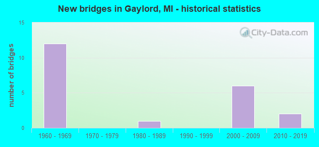
- New bridges - historical statistics
- 121960-1969
- 11980-1989
- 62000-2009
- 22010-2019

- Reconstructed bridges - Historical Statistics
- 31980-1989
- 11990-1999


- Bridge Condition - Deck
- 15.4%Very good
- 15.4%Good
- 38.5%Satisfactory
- 23.1%Fair
- 7.7%Poor

- Bridge Condition - Superstructure
- 7.7%Excellent
- 7.7%Very good
- 7.7%Good
- 30.8%Satisfactory
- 30.8%Fair
- 15.4%Poor

- Bridge Condition - Substructure
- 7.7%Excellent
- 7.7%Very good
- 15.4%Good
- 30.8%Satisfactory
- 38.5%Fair

- Bridge Condition - Channel
- 50.0%Very good
- 50.0%Good
Find on map >> Show street view
Structure Number: 1733, Location: SEC. 24-25 GRANT TWP. (Lat: 43.843919, Lng: -84.728792), Route carried "on" structure: County highway , Year Built: 1981, Status: Open, Structure Length: 1.22m (4.00ft), Average Daily Traffic: 950 (year 2006), Average Future Daily Traffic: 1,700 (year 2026), Design Load: HS 20+Mod, Features Intersected: MC CURRAN CREEK, Facility Carried by Structure: COLONVILLE ROAD
Minimum Vertical Clearance: 30.48m (100.00ft), Kilometerpoint: 3.167, Lanes on structure: 2, Owner: County Highway Agency, Approaching Roadway Width: 9.8m (32.2ft), Material/Design: Prestressed concrete, Design/Construction: Tee Beam, Number Of Spans In Main Unit: 1, Length of Maximum Span: 11.2m (36.7ft), Curb-To-Curb Width: 10.4m (34.1ft), Out-to-Out Width: 11.0m (36.1ft)
Condition: Deck: Satisfactory, Superstructure: Satisfactory, Substructure: Good, Channel: Good, Operating Rating: 53.1 metric tons, Method Used To Determine Operating Rating: Load Factor (LF) rating reported by rating factor (RF) method using MS18 loading, Inventory Rating: 32.1 metric tons, Method Used To Determine Inventory Rating: Load Factor (LF) rating reported by rating factor (RF) method using MS18 loading, Structural Evaluation: Equal to present minimum criteria, Deck Geometry: Equal to present minimum criteria, Waterway Adequacy: Superior to present desirable criteria, Approach Roadway Alignment: Equal to present desirable criteria, Designated Inspection Frequency: Every 24 months, Inspection Date: July 2020, Deck Structure Type: Concrete Cast-file-Place, Wearing Surface/Protective System: Wearing Surface: Bituminous, Deck Protection: Epoxy Coated Reinforcing
Find on map >> Show street view
Structure Number: 1738, Location: GRANT TWP SEC 30 (Lat: 43.829939, Lng: -84.838211), Route carried "on" structure: County highway , Year Built: 2010, Status: Open, Structure Length: 2.44m (8.01ft), Average Daily Traffic: 1,000 (year 2009), Truck Traffic: 3%, Average Future Daily Traffic: 1,800 (year 2029), Features Intersected: S BR TOBACCO RIVER, Facility Carried by Structure: BEAVER ROAD
Minimum Vertical Clearance: 30.48m (100.00ft), Kilometerpoint: 0.518, Lanes on structure: 2, Owner: County Highway Agency, Approaching Roadway Width: 11.0m (36.1ft), Skew: 3 degrees, Material/Design: Prestressed concrete, Design/Construction: Stringer/Multi-beam, Number Of Spans In Main Unit: 1, Length of Maximum Span: 23.2m (76.1ft), Curb-To-Curb Width: 11.0m (36.1ft), Out-to-Out Width: 11.8m (38.7ft)
Condition: Deck: Good, Superstructure: Excellent, Substructure: Excellent, Channel: Very good, Operating Rating: 61.7 metric tons, Method Used To Determine Operating Rating: Field evaluation and documented engineering judgment, Inventory Rating: 34.3 metric tons, Method Used To Determine Inventory Rating: Field evaluation and documented engineering judgment, Structural Evaluation: Superior to present desirable criteria, Deck Geometry: Better than present minimum criteria, Waterway Adequacy: Superior to present desirable criteria, Approach Roadway Alignment: Equal to present desirable criteria, Designated Inspection Frequency: Every 24 months, Inspection Date: July 2020, Deck Structure Type: Concrete Cast-file-Place, Wearing Surface/Protective System: Wearing Surface: Monolithic Concrete, Deck Protection: Epoxy Coated Reinforcing
Find on map >> Show street view
Structure Number: 5572, Location: 0.5 MI W OF WILMOTH HWY (Lat: 41.919478, Lng: -83.974075), Route carried "on" structure: County highway 4650, Year Built: 2008, Status: Open, Structure Length: 6.71m (22.01ft), Average Daily Traffic: 1,382 (year 2011), Truck Traffic: 2%, Average Future Daily Traffic: 4,314 (year 2031), Design Load: HS 25 or greater, Features Intersected: RIVER RAISIN, Facility Carried by Structure: LABERDEE RD
Minimum Vertical Clearance: 30.48m (100.00ft), Kilometerpoint: 2.395, Lanes on structure: 2, Owner: County Highway Agency, Approaching Roadway Width: 10.4m (34.1ft), Skew: 2 degrees, Material/Design: Prestressed concrete, Design/Construction: Box Beam or Girders - Multiple, Number Of Spans In Main Unit: 2, Length of Maximum Span: 32.0m (105.0ft), Curb-To-Curb Width: 10.7m (35.1ft), Out-to-Out Width: 11.3m (37.1ft)
Condition: Deck: Very good, Superstructure: Good, Substructure: Good, Channel: Good, Operating Rating: 94.8 metric tons, Method Used To Determine Operating Rating: Load Factor (LF), Inventory Rating: 56.9 metric tons, Method Used To Determine Inventory Rating: Load Factor (LF), Structural Evaluation: Better than present minimum criteria, Deck Geometry: Equal to present minimum criteria, Waterway Adequacy: Equal to present desirable criteria, Approach Roadway Alignment: Equal to present minimum criteria, Designated Inspection Frequency: Every 24 months, Inspection Date: December 2020, Deck Structure Type: Concrete Cast-file-Place, Wearing Surface/Protective System: Deck Protection: Epoxy Coated Reinforcing
Find on map >> Show street view
Structure Number: 867, Location: 2.7 MI S OF M-32 (Lat: 44.991203, Lng: -84.681342), Route carried "on" structure: Interstate 75, Year Built: 1962, Status: Open, Structure Length: 5.91m (19.39ft), Average Daily Traffic: 6,791 (year 2007), Truck Traffic: 10%, Average Future Daily Traffic: 9,705 (year 2018), Design Load: HS 20+Mod, Features Intersected: D&M RR
Minimum Vertical Clearance: 30.48m (100.00ft), Kilometerpoint: 16.154, Lanes on structure: 2, Base Highway Network: Yes (Inventory Route: 108, Subroute: 5), Owner: State Highway Agency, Approaching Roadway Width: 13.7m (44.9ft), Skew: 14 degrees, Material/Design: Steel, Design/Construction: Stringer/Multi-beam, Number Of Spans In Main Unit: 3, Length of Maximum Span: 19.8m (65.0ft), Curb-To-Curb Width: 11.6m (38.1ft), Out-to-Out Width: 13.3m (43.6ft)
Condition: Deck: Fair, Superstructure: Fair, Substructure: Fair, Operating Rating: 84.6 metric tons, Method Used To Determine Operating Rating: Load Factor (LF) rating reported by rating factor (RF) method using MS18 loading, Inventory Rating: 50.5 metric tons, Method Used To Determine Inventory Rating: Load Factor (LF) rating reported by rating factor (RF) method using MS18 loading, Structural Evaluation: Somewhat better than minimum adequacy, Deck Geometry: Equal to present minimum criteria, Approach Roadway Alignment: Equal to present minimum criteria, Designated Inspection Frequency: Every 17 months, Inspection Date: May 2021, Bridge Improvement Cost: $129,000, Deck Structure Type: Concrete Cast-file-Place, Wearing Surface/Protective System: Wearing Surface: Latex Concrete
Find on map >> Show street view
Structure Number: 8671, Location: 2.7 MI S OF M-32 (Lat: 44.990836, Lng: -84.681372), Route carried "on" structure: Interstate 75, Year Built: 1962, Status: Open, Structure Length: 5.91m (19.39ft), Average Daily Traffic: 6,791 (year 2007), Truck Traffic: 10%, Average Future Daily Traffic: 9,705 (year 2018), Design Load: HS 20+Mod, Features Intersected: D&M RR
Minimum Vertical Clearance: 30.48m (100.00ft), Kilometerpoint: 16.149, Lanes on structure: 2, Base Highway Network: Yes (Inventory Route: 108, Subroute: 10), Owner: State Highway Agency, Approaching Roadway Width: 13.7m (44.9ft), Skew: 14 degrees, Material/Design: Steel, Design/Construction: Stringer/Multi-beam, Number Of Spans In Main Unit: 3, Length of Maximum Span: 19.8m (65.0ft), Curb-To-Curb Width: 11.6m (38.1ft), Out-to-Out Width: 13.3m (43.6ft)
Condition: Deck: Satisfactory, Superstructure: Fair, Substructure: Fair, Operating Rating: 84.6 metric tons, Method Used To Determine Operating Rating: Load Factor (LF) rating reported by rating factor (RF) method using MS18 loading, Inventory Rating: 50.5 metric tons, Method Used To Determine Inventory Rating: Load Factor (LF) rating reported by rating factor (RF) method using MS18 loading, Structural Evaluation: Somewhat better than minimum adequacy, Deck Geometry: Equal to present minimum criteria, Underclear: Better than present minimum criteria, Approach Roadway Alignment: Equal to present minimum criteria, Designated Inspection Frequency: Every 17 months, Inspection Date: May 2021, Bridge Improvement Cost: $129,000, Deck Structure Type: Concrete Cast-file-Place, Wearing Surface/Protective System: Wearing Surface: Epoxy Overlay
Find on map >> Show street view
Structure Number: 8674, Location: 5.1 MI S OF M-32 (Lat: 44.957897, Lng: -84.674225), Route carried "on" structure: Interstate 75, Year Built: 1961, Year Reconstructed: 1980, Status: Open, Structure Length: 3.44m (11.29ft), Average Daily Traffic: 7,041 (year 2007), Truck Traffic: 10%, Average Future Daily Traffic: 11,274 (year 2018), Design Load: HS 20, Features Intersected: CHARLES BRINK RD
Minimum Vertical Clearance: 30.48m (100.00ft), Kilometerpoint: 12.157, Lanes on structure: 2, Lanes under structure: 2, Base Highway Network: Yes (Inventory Route: 108, Subroute: 10), Owner: State Highway Agency, Approaching Roadway Width: 13.7m (44.9ft), Material/Design: Prestressed concrete, Design/Construction: Stringer/Multi-beam, Number Of Spans In Main Unit: 3, Length of Maximum Span: 12.5m (41.0ft), Curb-To-Curb Width: 12.0m (39.4ft), Out-to-Out Width: 13.3m (43.6ft)
Condition: Deck: Fair, Superstructure: Fair, Substructure: Fair, Operating Rating: 61.9 metric tons, Method Used To Determine Operating Rating: Load Factor (LF) rating reported by rating factor (RF) method using MS18 loading, Inventory Rating: 36.9 metric tons, Method Used To Determine Inventory Rating: Load Factor (LF) rating reported by rating factor (RF) method using MS18 loading, Structural Evaluation: Somewhat better than minimum adequacy, Deck Geometry: Equal to present minimum criteria, Underclear: Better than present minimum criteria, Approach Roadway Alignment: Equal to present minimum criteria, Designated Inspection Frequency: Every 24 months, Other Special Inspection Frequency: Every 12 months, Inspection Date: September 2020, Other Special Inspection Date: September 2021, Deck Structure Type: Concrete Cast-file-Place, Wearing Surface/Protective System: Wearing Surface: Latex Concrete, Deck Protection: Epoxy Coated Reinforcing
Find on map >> Show street view
Structure Number: 8675, Location: 5.1 MI S OF M-32 (Lat: 44.957903, Lng: -84.673453), Route carried "on" structure: Interstate 75, Year Built: 1961, Year Reconstructed: 1980, Status: Open, Structure Length: 3.38m (11.09ft), Average Daily Traffic: 7,041 (year 2007), Truck Traffic: 10%, Average Future Daily Traffic: 11,274 (year 2018), Design Load: HS 20, Features Intersected: CHARLES BRINK RD
Minimum Vertical Clearance: 30.48m (100.00ft), Kilometerpoint: 12.108, Lanes on structure: 2, Lanes under structure: 2, Base Highway Network: Yes (Inventory Route: 108, Subroute: 5), Owner: State Highway Agency, Approaching Roadway Width: 13.7m (44.9ft), Skew: 1 degrees, Material/Design: Prestressed concrete, Design/Construction: Stringer/Multi-beam, Number Of Spans In Main Unit: 3, Length of Maximum Span: 12.5m (41.0ft), Curb-To-Curb Width: 12.0m (39.4ft), Out-to-Out Width: 13.3m (43.6ft)
Condition: Deck: Satisfactory, Superstructure: Satisfactory, Substructure: Satisfactory, Operating Rating: 51.2 metric tons, Method Used To Determine Operating Rating: Load Factor (LF) rating reported by rating factor (RF) method using MS18 loading, Inventory Rating: 30.5 metric tons, Method Used To Determine Inventory Rating: Load Factor (LF) rating reported by rating factor (RF) method using MS18 loading, Structural Evaluation: Equal to present minimum criteria, Deck Geometry: Equal to present minimum criteria, Underclear: Better than present minimum criteria, Approach Roadway Alignment: Equal to present minimum criteria, Designated Inspection Frequency: Every 24 months, Inspection Date: September 2020, Deck Structure Type: Concrete Cast-file-Place, Wearing Surface/Protective System: Wearing Surface: Epoxy Overlay, Deck Protection: Epoxy Coated Reinforcing
Find on map >> Show street view
Structure Number: 8677, Location: IN GAYLORD (OVER M-32 ) (Lat: 45.027392, Lng: -84.688247), Route carried "on" structure: Interstate 75, Year Built: 1961, Year Reconstructed: 1997, Status: Open, Structure Length: 4.08m (13.39ft), Average Daily Traffic: 6,791 (year 2007), Truck Traffic: 7%, Average Future Daily Traffic: 9,190 (year 2018), Design Load: HS 25 or greater, Features Intersected: M-32
Minimum Vertical Clearance: 30.48m (100.00ft), Kilometerpoint: 20.359, Lanes on structure: 2, Lanes under structure: 4, Base Highway Network: Yes (Inventory Route: 108, Subroute: 10), Owner: State Highway Agency, Approaching Roadway Width: 20.0m (65.6ft), Skew: 1 degrees, Material/Design: Prestressed concrete, Design/Construction: Stringer/Multi-beam, Number Of Spans In Main Unit: 3, Length of Maximum Span: 19.8m (65.0ft), Curb-To-Curb Width: 16.8m (55.1ft), Out-to-Out Width: 17.9m (58.7ft)
Condition: Deck: Fair, Superstructure: Poor, Substructure: Fair, Operating Rating: 64.8 metric tons, Method Used To Determine Operating Rating: Load Factor (LF) rating reported by rating factor (RF) method using MS18 loading, Inventory Rating: 39.5 metric tons, Method Used To Determine Inventory Rating: Load Factor (LF) rating reported by rating factor (RF) method using MS18 loading, Structural Evaluation: Meets minimum limits, Deck Geometry: Superior to present desirable criteria, Underclear: High priority of corrective action, Approach Roadway Alignment: Better than present minimum criteria, Designated Inspection Frequency: Every 12 months, Inspection Date: May 2021, Deck Structure Type: Concrete Cast-file-Place, Wearing Surface/Protective System: Wearing Surface: Latex Concrete
Find on map >> Show street view
Structure Number: 8678, Location: IN GAYLORD (OVER M-32) (Lat: 45.027397, Lng: -84.687633), Route carried "on" structure: Interstate 75, Year Built: 1961, Year Reconstructed: 1980, Status: Open, Structure Length: 4.08m (13.39ft), Average Daily Traffic: 6,791 (year 2007), Truck Traffic: 7%, Average Future Daily Traffic: 9,190 (year 2018), Design Load: HS 20+Mod, Features Intersected: M-32
Minimum Vertical Clearance: 30.48m (100.00ft), Kilometerpoint: 20.304, Lanes on structure: 2, Lanes under structure: 4, Base Highway Network: Yes (Inventory Route: 108, Subroute: 5), Owner: State Highway Agency, Approaching Roadway Width: 13.7m (44.9ft), Skew: 1 degrees, Material/Design: Prestressed concrete, Design/Construction: Stringer/Multi-beam, Number Of Spans In Main Unit: 3, Length of Maximum Span: 19.8m (65.0ft), Curb-To-Curb Width: 12.0m (39.4ft), Out-to-Out Width: 13.3m (43.6ft)
Condition: Deck: Poor, Superstructure: Poor, Substructure: Fair, Operating Rating: 80.0 metric tons, Method Used To Determine Operating Rating: Load Factor (LF) rating reported by rating factor (RF) method using MS18 loading, Inventory Rating: 48.0 metric tons, Method Used To Determine Inventory Rating: Load Factor (LF) rating reported by rating factor (RF) method using MS18 loading, Structural Evaluation: Meets minimum limits, Deck Geometry: Equal to present minimum criteria, Underclear: High priority of corrective action, Approach Roadway Alignment: Better than present minimum criteria, Designated Inspection Frequency: Every 12 months, Inspection Date: May 2021, Deck Structure Type: Concrete Cast-file-Place, Wearing Surface/Protective System: Wearing Surface: Latex Concrete
Find on map >> Show street view
Structure Number: 13401, Location: SOUTH END OF GAYLORD (Lat: 45.003383, Lng: -84.685289), Route carried "on" structure: Interstate 75, Year Built: 2009, Status: Open, Structure Length: 3.66m (12.01ft), Average Daily Traffic: 6,450 (year 2008), Truck Traffic: 10%, Average Future Daily Traffic: 7,700 (year 2028), Design Load: HS 25 or greater, Features Intersected: MC COY ROAD
Minimum Vertical Clearance: 30.48m (100.00ft), Kilometerpoint: 17.610, Lanes on structure: 2, Lanes under structure: 2, Base Highway Network: Yes (Inventory Route: 108, Subroute: 5), Owner: State Highway Agency, Approaching Roadway Width: 13.4m (44.0ft), Material/Design: Prestressed concrete, Design/Construction: Box Beam or Girders - Multiple, Number Of Spans In Main Unit: 1, Length of Maximum Span: 35.8m (117.5ft), Curb-To-Curb Width: 13.4m (44.0ft), Out-to-Out Width: 14.4m (47.2ft)
Condition: Deck: Satisfactory, Superstructure: Fair, Substructure: Satisfactory, Operating Rating: 91.4 metric tons, Method Used To Determine Operating Rating: Load Factor (LF) rating reported by rating factor (RF) method using MS18 loading, Inventory Rating: 40.2 metric tons, Method Used To Determine Inventory Rating: Load Factor (LF) rating reported by rating factor (RF) method using MS18 loading, Structural Evaluation: Somewhat better than minimum adequacy, Deck Geometry: Superior to present desirable criteria, Underclear: Equal to present minimum criteria, Approach Roadway Alignment: Equal to present desirable criteria, Designated Inspection Frequency: Every 24 months, Inspection Date: September 2020, Deck Structure Type: Concrete Cast-file-Place, Wearing Surface/Protective System: Wearing Surface: Epoxy Overlay, Deck Protection: Epoxy Coated Reinforcing
Find on map >> Show street view
Structure Number: 13402, Location: SOUTH END OF GAYLORD (Lat: 45.003492, Lng: -84.686078), Route carried "on" structure: Interstate 75, Year Built: 2009, Status: Open, Structure Length: 3.66m (12.01ft), Average Daily Traffic: 6,450 (year 2008), Truck Traffic: 10%, Average Future Daily Traffic: 7,700 (year 2028), Design Load: HS 25 or greater, Features Intersected: MC COY ROAD
Minimum Vertical Clearance: 30.48m (100.00ft), Kilometerpoint: 17.670, Lanes on structure: 2, Lanes under structure: 2, Base Highway Network: Yes (Inventory Route: 108, Subroute: 10), Owner: State Highway Agency, Approaching Roadway Width: 13.4m (44.0ft), Material/Design: Prestressed concrete, Design/Construction: Box Beam or Girders - Multiple, Number Of Spans In Main Unit: 1, Length of Maximum Span: 35.8m (117.5ft), Curb-To-Curb Width: 13.4m (44.0ft), Out-to-Out Width: 14.4m (47.2ft)
Condition: Deck: Satisfactory, Superstructure: Satisfactory, Substructure: Satisfactory, Operating Rating: 91.4 metric tons, Method Used To Determine Operating Rating: Load Factor (LF) rating reported by rating factor (RF) method using MS18 loading, Inventory Rating: 40.2 metric tons, Method Used To Determine Inventory Rating: Load Factor (LF) rating reported by rating factor (RF) method using MS18 loading, Structural Evaluation: Equal to present minimum criteria, Deck Geometry: Superior to present desirable criteria, Underclear: Equal to present minimum criteria, Approach Roadway Alignment: Equal to present desirable criteria, Designated Inspection Frequency: Every 24 months, Inspection Date: September 2020, Deck Structure Type: Concrete Cast-file-Place, Wearing Surface/Protective System: Wearing Surface: Epoxy Overlay, Deck Protection: Epoxy Coated Reinforcing
Find on map >> Show street view
Structure Number: 1365, Location: 2.0 MI NE OF GAYLORD (Lat: 45.070214, Lng: -84.640753), Route carried "on" structure: County highway , Year Built: 2013, Status: Open, Structure Length: 0.98m (3.22ft), Average Daily Traffic: 505 (year 2012), Truck Traffic: 3%, Average Future Daily Traffic: 912 (year 2032), Design Load: HS 20+Mod, Features Intersected: STURGEON RIVER, Facility Carried by Structure: POQUETTE ROAD
Minimum Vertical Clearance: 30.48m (100.00ft), Kilometerpoint: 16.941, Lanes on structure: 2, Owner: County Highway Agency, Approaching Roadway Width: 11.0m (36.1ft), Material/Design: Wood or Timber, Design/Construction: Slab, Number Of Spans In Main Unit: 1, Length of Maximum Span: 9.1m (29.9ft), Curb-To-Curb Width: 11.0m (36.1ft), Out-to-Out Width: 11.6m (38.1ft)
Condition: Deck: Very good, Superstructure: Very good, Substructure: Very good, Channel: Very good, Operating Rating: 54.8 metric tons, Method Used To Determine Operating Rating: Load and Resistance Factor Rating (LRFR) rating reported by rating factor(RF) method using HL-93 loadings, Inventory Rating: 42.1 metric tons, Method Used To Determine Inventory Rating: Load and Resistance Factor Rating (LRFR) rating reported by rating factor(RF) method using HL-93 loadings, Structural Evaluation: Equal to present desirable criteria, Deck Geometry: Better than present minimum criteria, Waterway Adequacy: Better than present minimum criteria, Approach Roadway Alignment: Equal to present desirable criteria, Designated Inspection Frequency: Every 24 months, Inspection Date: August 2020, Deck Structure Type: Wood or Timber, Wearing Surface/Protective System: Wearing Surface: Bituminous, Membrane: Preformed Fabric, Deck Protection: Other
Find on map >> Show street view
Structure Number: 13912, Location: 0.4 W OF OLD 27 (Lat: 45.056333, Lng: -84.682217), Route carried "on" structure: County highway , Year Built: 2009, Status: Posted for load, Structure Length: 3.96m (12.99ft), Average Daily Traffic: 200 (year 2013), Truck Traffic: 3%, Average Future Daily Traffic: 225 (year 2020), Design Load: H 10, Features Intersected: GAYLORD/MAC RAIL TRAIL, Facility Carried by Structure: CONGDON ROAD
Minimum Vertical Clearance: 30.48m (100.00ft), Kilometerpoint: 1.273, Lanes on structure: 1, Owner: County Highway Agency, Approaching Roadway Width: 4.3m (14.1ft), Material/Design: Wood or Timber, Design/Construction: Stringer/Multi-beam, Number Of Spans In Main Unit: 5, Length of Maximum Span: 9.8m (32.2ft), Curb-To-Curb Width: 4.6m (15.1ft), Out-to-Out Width: 4.9m (16.1ft)
Condition: Deck: Good, Superstructure: Satisfactory, Substructure: Satisfactory, Operating Rating: 2.9 metric tons, Method Used To Determine Operating Rating: Allowable Stress (AS) rating reported by rating factor (RF) method using MS18 loading, Inventory Rating: 1.6 metric tons, Method Used To Determine Inventory Rating: Allowable Stress (AS) rating reported by rating factor (RF) method using MS18 loading, Structural Evaluation: High priority of corrective action, Deck Geometry: High priority of replacement, Approach Roadway Alignment: Equal to present minimum criteria, Bridge Posting: Required (Relationship of Operating Rating to Maximum Legal Load: > 39.9% below), Designated Inspection Frequency: Every 24 months, Inspection Date: August 2020, Deck Structure Type: Wood or Timber, Wearing Surface/Protective System: Wearing Surface: Wood or Timber
Find on map >> Show street view
Structure Number: 8674, Location: 5.1 MI S OF M-32 (Lat: 44.957897, Lng: -84.674225), Route carried "under" structure: County highway 6945, Year Built: 1961, Structure Length: 0. m, Average Daily Traffic: 450 (year 1988), Features Intersected: CHARLES BRINK RD, Facility Carried by Structure: I-75 SB
Minimum Vertical Clearance: 4.98m (16.34ft), Kilometerpoint: 0.591, Lanes on structure: 2, Lanes under structure: 2, Material/Design: Prestressed concrete, Design/Construction: Stringer/Multi-beam, Length of Maximum Span: 12.5m (41.0ft)
Find on map >> Show street view
Structure Number: 8675, Location: 5.1 MI S OF M-32 (Lat: 44.957903, Lng: -84.673453), Route carried "under" structure: County highway 6945, Year Built: 1961, Structure Length: 0. m, Average Daily Traffic: 450 (year 1988), Features Intersected: CHARLES BRINK RD, Facility Carried by Structure: I-75 NB
Minimum Vertical Clearance: 5.08m (16.67ft), Kilometerpoint: 0.652, Lanes on structure: 2, Lanes under structure: 2, Material/Design: Prestressed concrete, Design/Construction: Stringer/Multi-beam, Length of Maximum Span: 12.5m (41.0ft)
Find on map >> Show street view
Structure Number: 8676, Location: 2.7 MI S OF M-32 (Lat: 44.987883, Lng: -84.677158), Route carried "under" structure: Interstate 75, Year Built: 1961, Structure Length: 0. m, Average Daily Traffic: 14,082 (year 2007), Truck Traffic: 10%, Features Intersected: I-75, Facility Carried by Structure: OLD US-27,ALBA RD
Minimum Vertical Clearance: 5.03m (16.50ft), Kilometerpoint: 15.659, Lanes on structure: 5, Lanes under structure: 6, Material/Design: Steel, Design/Construction: Stringer/Multi-beam, Length of Maximum Span: 28.0m (91.9ft)
Find on map >> Show street view
Structure Number: 8677, Location: IN GAYLORD (OVER M-32 ) (Lat: 45.027392, Lng: -84.688247), Route carried "under" structure: State highway 32, Year Built: 1961, Structure Length: 0. m, Average Daily Traffic: 23,981 (year 2007), Truck Traffic: 5%, Features Intersected: M-32, Facility Carried by Structure: I-75 SB
Minimum Vertical Clearance: 5.11m (16.77ft), Kilometerpoint: 17.026, Lanes on structure: 2, Lanes under structure: 4, Material/Design: Prestressed concrete, Design/Construction: Stringer/Multi-beam, Length of Maximum Span: 19.8m (65.0ft)
Find on map >> Show street view
Structure Number: 8678, Location: IN GAYLORD (OVER M-32) (Lat: 45.027397, Lng: -84.687633), Route carried "under" structure: State highway 32, Year Built: 1961, Structure Length: 0. m, Average Daily Traffic: 27,196 (year 2007), Truck Traffic: 3%, Features Intersected: M-32, Facility Carried by Structure: I-75 NB
Minimum Vertical Clearance: 5.05m (16.57ft), Kilometerpoint: 17.074, Lanes on structure: 2, Lanes under structure: 4, Material/Design: Prestressed concrete, Design/Construction: Stringer/Multi-beam, Length of Maximum Span: 19.8m (65.0ft)
Find on map >> Show street view
Structure Number: 8679, Location: 3.0 MI N OF M-32 (Lat: 45.070822, Lng: -84.688947), Route carried "under" structure: Interstate 75, Year Built: 1961, Structure Length: 0. m, Average Daily Traffic: 13,036 (year 2007), Truck Traffic: 7%, Features Intersected: I-75, Facility Carried by Structure: PARMATER RD
Minimum Vertical Clearance: 5.03m (16.50ft), Kilometerpoint: 25.157, Lanes on structure: 2, Lanes under structure: 4, Material/Design: Steel, Design/Construction: Stringer/Multi-beam, Length of Maximum Span: 17.9m (58.7ft)
Find on map >> Show street view
Structure Number: 13401, Location: SOUTH END OF GAYLORD (Lat: 45.003383, Lng: -84.685289), Route carried "under" structure: County highway 42, Year Built: 2009, Structure Length: 0. m, Average Daily Traffic: 2,070 (year 2008), Truck Traffic: 5%, Features Intersected: MC COY ROAD, Facility Carried by Structure: I-75 NB
Minimum Vertical Clearance: 4.75m (15.58ft), Kilometerpoint: 0.174, Lanes on structure: 2, Lanes under structure: 2, Material/Design: Prestressed concrete, Design/Construction: Box Beam or Girders - Multiple, Length of Maximum Span: 35.8m (117.5ft)
Find on map >> Show street view
Structure Number: 13402, Location: SOUTH END OF GAYLORD (Lat: 45.003492, Lng: -84.686078), Route carried "under" structure: County highway 42, Year Built: 2009, Structure Length: 0. m, Average Daily Traffic: 2,070 (year 2008), Features Intersected: MC COY ROAD, Facility Carried by Structure: I-75 SB
Minimum Vertical Clearance: 4.55m (14.93ft), Kilometerpoint: 0.134, Lanes on structure: 2, Lanes under structure: 2, Material/Design: Prestressed concrete, Design/Construction: Box Beam or Girders - Multiple, Length of Maximum Span: 35.8m (117.5ft)