Bridge Statistics for Gastonville, Pennsylvania (PA)
Condition, Traffic, Stress, Structural Evaluation, Project Costs
- National Bridge Inventory (NBI) Statistics
- 18Number of bridges
- 164ft / 49.9mTotal length
- $875,000Total costs
- 94,116Total average daily traffic
- 4,481Total average daily truck traffic
- National Bridge Inventory (NBI) Registered Bridges for Gastonville
- No street view available for this location
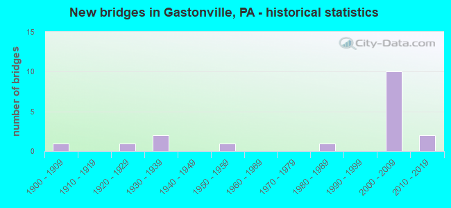
- New bridges - historical statistics
- 11900-1909
- 11920-1929
- 21930-1939
- 11950-1959
- 11980-1989
- 102000-2009
- 22010-2019

- Reconstructed bridges - Historical Statistics
- 11940-1949
- 01950-1959
- 01960-1969
- 11970-1979
- 21980-1989


- Bridge Condition - Deck
- 15.4%Very good
- 46.2%Good
- 23.1%Satisfactory
- 15.4%Poor

- Bridge Condition - Superstructure
- 23.1%Very good
- 46.2%Good
- 7.7%Satisfactory
- 7.7%Fair
- 15.4%Poor

- Bridge Condition - Substructure
- 7.7%Very good
- 53.8%Good
- 15.4%Satisfactory
- 7.7%Fair
- 15.4%Poor

- Bridge Condition - Channel
- 16.7%Excellent
- 16.7%Very good
- 8.3%Good
- 16.7%Satisfactory
- 25.0%Fair
- 16.7%Poor
Find on map >> Show street view
Structure Number: 23847, Location: HAZLE TWP .1 M N TR 940 (Lat: 40.977317, Lng: -75.979156), Route carried "on" structure: State highway 309, Year Built: 1928, Year Reconstructed: 1991, Status: Open, Structure Length: 0.82m (2.69ft), Average Daily Traffic: 18,552 (year 2020), Truck Traffic: 5%, Average Future Daily Traffic: 19,708 (year 2033), Design Load: HS 20, Features Intersected: BIG BLACK CREEK
Minimum Vertical Clearance: 30+ m (98+ ft), Kilometerpoint: 7.511, Lanes on structure: 5, Base Highway Network: Yes, Owner: State Highway Agency, Approaching Roadway Width: 17.1m (56.1ft), Skew: 2 degrees, Material/Design: Concrete, Design/Construction: Tee Beam, Number Of Spans In Main Unit: 1, Length of Maximum Span: 7.9m (25.9ft), Curb or Sidewalk Widths: Left: 1.6m (5.2ft), Right: 0.0m, Curb-To-Curb Width: 17.2m (56.4ft), Out-to-Out Width: 19.7m (64.6ft)
Condition: Deck: Satisfactory, Superstructure: Satisfactory, Substructure: Satisfactory, Channel: Fair, Operating Rating: 59.9 metric tons, Method Used To Determine Operating Rating: Load Factor (LF), Inventory Rating: 36.3 metric tons, Method Used To Determine Inventory Rating: Load Factor (LF), Structural Evaluation: Equal to present minimum criteria, Deck Geometry: High priority of replacement, Waterway Adequacy: High priority of corrective action, Approach Roadway Alignment: Equal to present desirable criteria, Length Of Structure Improvement: 1.40m (4.59ft), Designated Inspection Frequency: Every 24 months, Inspection Date: January 2021, Bridge Improvement Cost: $16,000, Roadway Improvement Cost: $100,000, Total Project Cost: $218,000, Deck Structure Type: Concrete Cast-file-Place, Wearing Surface/Protective System: Wearing Surface: Bituminous, Membrane: Preformed Fabric
Find on map >> Show street view
Structure Number: 34624, Location: UNION TOWNSHIP (Lat: 40.260250, Lng: -80.001581), Route carried "on" structure: State highway 88, Year Built: 1907, Year Reconstructed: 1988, Status: Open, Structure Length: 0.73m (2.40ft), Average Daily Traffic: 8,639 (year 2020), Truck Traffic: 3%, Average Future Daily Traffic: 10,879 (year 2032), Design Load: HS 25 or greater, Features Intersected: BRANCH OF PETERS CREEK
Minimum Vertical Clearance: 30+ m (98+ ft), Kilometerpoint: 52.297, Lanes on structure: 2, Base Highway Network: Yes, Owner: State Highway Agency, Approaching Roadway Width: 8.5m (27.9ft), Skew: 3 degrees, Material/Design: Prestressed concrete, Design/Construction: Slab, Number Of Spans In Main Unit: 1, Length of Maximum Span: 6.7m (22.0ft), Curb or Sidewalk Widths: Left: 0.2m (0.7ft), Right: 0.2m (0.7ft), Curb-To-Curb Width: 9.4m (30.8ft), Out-to-Out Width: 10.1m (33.1ft)
Condition: Deck: Satisfactory, Superstructure: Good, Substructure: Satisfactory, Channel: Poor, Operating Rating: 89.8 metric tons, Method Used To Determine Operating Rating: Load Factor (LF), Inventory Rating: 58.1 metric tons, Method Used To Determine Inventory Rating: Load Factor (LF), Structural Evaluation: Equal to present minimum criteria, Deck Geometry: High priority of corrective action, Waterway Adequacy: Superior to present desirable criteria, Approach Roadway Alignment: Equal to present desirable criteria, Length Of Structure Improvement: 0.90m (2.95ft), Designated Inspection Frequency: Every 48 months, Inspection Date: September 2019, Bridge Improvement Cost: $2,000, Roadway Improvement Cost: $5,000, Total Project Cost: $22,000, Deck Structure Type: Concrete Cast-file-Place, Wearing Surface/Protective System: Wearing Surface: Monolithic Concrete
Find on map >> Show street view
Structure Number: 34781, Location: PETERS TOWNSHIP (Lat: 40.246694, Lng: -80.043592), Route carried "on" structure: State highway , Year Built: 1984, Status: Open, Structure Length: 0.70m (2.30ft), Average Daily Traffic: 12,263 (year 2020), Truck Traffic: 6%, Average Future Daily Traffic: 5,961 (year 2032), Design Load: HS 20+Mod, Features Intersected: BRANCH OF PETERS CREEK, Facility Carried by Structure: SR 1006
Minimum Vertical Clearance: 30+ m (98+ ft), Kilometerpoint: 13.092, Lanes on structure: 2, Owner: State Highway Agency, Approaching Roadway Width: 8.5m (27.9ft), Material/Design: Concrete, Design/Construction: Slab, Number Of Spans In Main Unit: 1, Length of Maximum Span: 6.7m (22.0ft), Curb-To-Curb Width: 8.6m (28.2ft), Out-to-Out Width: 9.8m (32.2ft)
Condition: Deck: Good, Superstructure: Good, Substructure: Good, Channel: Satisfactory, Operating Rating: 75.3 metric tons, Method Used To Determine Operating Rating: Load Factor (LF), Inventory Rating: 45.4 metric tons, Method Used To Determine Inventory Rating: Load Factor (LF), Structural Evaluation: Better than present minimum criteria, Deck Geometry: High priority of replacement, Waterway Adequacy: Equal to present desirable criteria, Approach Roadway Alignment: Equal to present desirable criteria, Length Of Structure Improvement: 1.30m (4.27ft), Designated Inspection Frequency: Every 24 months, Inspection Date: March 2020, Wearing Surface/Protective System: Wearing Surface: Bituminous, Deck Protection: Epoxy Coated Reinforcing
Find on map >> Show street view
Structure Number: 34819, Location: NOTTINGHAM TOWNSHIP (Lat: 40.223864, Lng: -80.039878), Route carried "on" structure: State highway , Year Built: 1939, Year Reconstructed: 1949, Status: Posted for load, Structure Length: 0.76m (2.49ft), Average Daily Traffic: 720 (year 2020), Truck Traffic: 5%, Average Future Daily Traffic: 800 (year 2042), Design Load: H 20, Features Intersected: BRANCH OF MINGO CREEK, Facility Carried by Structure: SR 1016
Minimum Vertical Clearance: 30+ m (98+ ft), Kilometerpoint: 0.000, Lanes on structure: 1, Owner: State Highway Agency, Approaching Roadway Width: 5.8m (19.0ft), Skew: 1 degrees, Material/Design: Steel, Design/Construction: Stringer/Multi-beam, Number Of Spans In Main Unit: 1, Length of Maximum Span: 7.3m (24.0ft), Curb or Sidewalk Widths: Left: 0.2m (0.7ft), Right: 0.2m (0.7ft), Curb-To-Curb Width: 4.3m (14.1ft), Out-to-Out Width: 4.9m (16.1ft)
Condition: Deck: Poor, Superstructure: Poor, Substructure: Poor, Channel: Fair, Operating Rating: 24.5 metric tons, Method Used To Determine Operating Rating: Load Factor (LF), Inventory Rating: 14.5 metric tons, Method Used To Determine Inventory Rating: Load Factor (LF), Structural Evaluation: Meets minimum limits, Deck Geometry: High priority of replacement, Waterway Adequacy: Better than present minimum criteria, Approach Roadway Alignment: Equal to present desirable criteria, Bridge Posting: Required (Relationship of Operating Rating to Maximum Legal Load: > 39.9% below), Length Of Structure Improvement: 0.80m (2.62ft), Designated Inspection Frequency: Every 24 months, Other Special Inspection Frequency: Every 12 months, Inspection Date: March 2020, Other Special Inspection Date: March 2021, Bridge Improvement Cost: $16,000, Roadway Improvement Cost: $150,000, Total Project Cost: $221,000, Deck Structure Type: Closed Grating, Wearing Surface/Protective System: Wearing Surface: Bituminous
Find on map >> Show street view
Structure Number: 3482, Location: NOTTINGHAM TOWNSHIP (Lat: 40.217128, Lng: -80.028128), Route carried "on" structure: State highway , Year Built: 1955, Status: Open, Structure Length: 0.79m (2.59ft), Average Daily Traffic: 720 (year 2020), Truck Traffic: 5%, Average Future Daily Traffic: 430 (year 2032), Design Load: H 20, Features Intersected: LITTLE MINGO CREEK, Facility Carried by Structure: SR 1016
Minimum Vertical Clearance: 30+ m (98+ ft), Kilometerpoint: 1.426, Lanes on structure: 2, Owner: State Highway Agency, Approaching Roadway Width: 7.0m (23.0ft), Skew: 3 degrees, Material/Design: Steel, Design/Construction: Stringer/Multi-beam, Number Of Spans In Main Unit: 1, Length of Maximum Span: 6.7m (22.0ft), Curb or Sidewalk Widths: Left: 0.4m (1.3ft), Right: 0.4m (1.3ft), Curb-To-Curb Width: 7.5m (24.6ft), Out-to-Out Width: 8.2m (26.9ft)
Condition: Deck: Good, Superstructure: Poor, Substructure: Fair, Channel: Poor, Operating Rating: 81.6 metric tons, Method Used To Determine Operating Rating: Load Factor (LF), Inventory Rating: 49.0 metric tons, Method Used To Determine Inventory Rating: Load Factor (LF), Structural Evaluation: Meets minimum limits, Deck Geometry: Meets minimum limits, Waterway Adequacy: Superior to present desirable criteria, Approach Roadway Alignment: Better than present minimum criteria, Length Of Structure Improvement: 0.80m (2.62ft), Designated Inspection Frequency: Every 24 months, Inspection Date: March 2020, Bridge Improvement Cost: $16,000, Roadway Improvement Cost: $150,000, Total Project Cost: $213,000, Deck Structure Type: Concrete Cast-file-Place, Wearing Surface/Protective System: Wearing Surface: Bituminous
Find on map >> Show street view
Structure Number: 34857, Location: NOTTINGHAM & PETERS TWPS. (Lat: 40.244939, Lng: -80.037119), Route carried "on" structure: State highway , Year Built: 1939, Year Reconstructed: 1979, Status: Open, Structure Length: 1.62m (5.31ft), Average Daily Traffic: 1,586 (year 2020), Truck Traffic: 2%, Average Future Daily Traffic: 1,138 (year 2032), Design Load: H 20, Features Intersected: PETERS CREEK, Facility Carried by Structure: SR 1059
Minimum Vertical Clearance: 30+ m (98+ ft), Kilometerpoint: 8.567, Lanes on structure: 2, Owner: State Highway Agency, Approaching Roadway Width: 5.5m (18.0ft), Skew: 4 degrees, Material/Design: Steel, Design/Construction: Stringer/Multi-beam, Number Of Spans In Main Unit: 1, Length of Maximum Span: 15.2m (49.9ft), Curb or Sidewalk Widths: Left: 0.2m (0.7ft), Right: 0.2m (0.7ft), Curb-To-Curb Width: 6.7m (22.0ft), Out-to-Out Width: 7.6m (24.9ft)
Condition: Deck: Poor, Superstructure: Fair, Substructure: Poor, Channel: Fair, Operating Rating: 73.5 metric tons, Method Used To Determine Operating Rating: Load Factor (LF), Inventory Rating: 44.5 metric tons, Method Used To Determine Inventory Rating: Load Factor (LF), Structural Evaluation: Meets minimum limits, Deck Geometry: High priority of corrective action, Waterway Adequacy: Superior to present desirable criteria, Approach Roadway Alignment: Equal to present minimum criteria, Length Of Structure Improvement: 1.60m (5.25ft), Designated Inspection Frequency: Every 24 months, Inspection Date: April 2020, Bridge Improvement Cost: $15,000, Roadway Improvement Cost: $44,000, Total Project Cost: $201,000, Deck Structure Type: Concrete Cast-file-Place, Wearing Surface/Protective System: Wearing Surface: Bituminous
Find on map >> Show street view
Structure Number: 41856, Location: MINGO CREEK COUNTY PARK (Lat: 40.200681, Lng: -80.032494), Route carried "on" structure: City street T392, Year Built: 2002, Status: Open, Structure Length: 1.77m (5.81ft), Average Daily Traffic: 50 (year 2001), Truck Traffic: 5%, Average Future Daily Traffic: 75 (year 2036), Design Load: HS 20+Mod, Features Intersected: MINGO CREEK, Facility Carried by Structure: MINGO BRIDGE
Minimum Vertical Clearance: 30+ m (98+ ft), Kilometerpoint: 0.000, Lanes on structure: 2, Owner: County Highway Agency, Approaching Roadway Width: 6.7m (22.0ft), Material/Design: Prestressed concrete, Design/Construction: Box Beam or Girders - Single/Spread, Number Of Spans In Main Unit: 1, Length of Maximum Span: 15.2m (49.9ft), Curb or Sidewalk Widths: Left: 0.1m (0.3ft), Right: 0.1m (0.3ft), Curb-To-Curb Width: 6.7m (22.0ft), Out-to-Out Width: 7.6m (24.9ft)
Condition: Deck: Very good, Superstructure: Very good, Substructure: Good, Channel: Satisfactory, Operating Rating: 71.7 metric tons, Method Used To Determine Operating Rating: Load and Resistance Factor (LRFR), Inventory Rating: 45.4 metric tons, Method Used To Determine Inventory Rating: Load and Resistance Factor (LRFR), Structural Evaluation: Better than present minimum criteria, Deck Geometry: Somewhat better than minimum adequacy, Waterway Adequacy: Superior to present desirable criteria, Approach Roadway Alignment: Equal to present desirable criteria, Designated Inspection Frequency: Every 24 months, Inspection Date: March 2021, Deck Structure Type: Concrete Cast-file-Place, Wearing Surface/Protective System: Wearing Surface: Monolithic Concrete, Deck Protection: Epoxy Coated Reinforcing
Find on map >> Show street view
Structure Number: 41974, Location: 0.5MI.N OF FINELYVILLE RD (Lat: 40.260556, Lng: -79.977778), Route carried "on" structure: Other road 43, Year Built: 2000, Status: Open, Structure Length: 11.37m (37.30ft), Average Daily Traffic: 5,533 (year 2008), Truck Traffic: 4%, Average Future Daily Traffic: 7,194 (year 2030), Design Load: HS 25 or greater, Features Intersected: SR1008
Minimum Vertical Clearance: 30+ m (98+ ft), Kilometerpoint: 0.000, Lanes on structure: 2, Lanes under structure: 2, Base Highway Network: Yes, Toll: On toll road, Owner: State Toll Authority, Approaching Roadway Width: 12.8m (42.0ft), Skew: 10 degrees, Material/Design: Steel continuous, Design/Construction: Stringer/Multi-beam, Number Of Spans In Main Unit: 3, Length of Maximum Span: 42.7m (140.1ft), Curb or Sidewalk Widths: Left: 0.2m (0.7ft), Right: 0.2m (0.7ft), Curb-To-Curb Width: 12.8m (42.0ft), Out-to-Out Width: 13.8m (45.3ft)
Condition: Deck: Good, Superstructure: Good, Substructure: Good, Operating Rating: 68.0 metric tons, Method Used To Determine Operating Rating: Load Factor (LF), Inventory Rating: 40.8 metric tons, Method Used To Determine Inventory Rating: Load Factor (LF), Structural Evaluation: Better than present minimum criteria, Deck Geometry: Equal to present desirable criteria, Underclear: Equal to present desirable criteria, Approach Roadway Alignment: Equal to present desirable criteria, Designated Inspection Frequency: Every 48 months, Inspection Date: June 2019, Deck Structure Type: Concrete Cast-file-Place, Wearing Surface/Protective System: Wearing Surface: Monolithic Concrete, Deck Protection: Epoxy Coated Reinforcing
Find on map >> Show street view
Structure Number: 41975, Location: 0.5MI.N OF FINELYVILLE RD (Lat: 40.260556, Lng: -79.977778), Route carried "on" structure: Other road 43, Year Built: 2000, Status: Open, Structure Length: 11.22m (36.81ft), Average Daily Traffic: 5,633 (year 2008), Truck Traffic: 4%, Average Future Daily Traffic: 7,324 (year 2030), Design Load: HS 25 or greater, Features Intersected: SR1008
Minimum Vertical Clearance: 30+ m (98+ ft), Kilometerpoint: 78.182, Lanes on structure: 2, Lanes under structure: 2, Base Highway Network: Yes, Toll: On toll road, Owner: State Toll Authority, Approaching Roadway Width: 15.2m (49.9ft), Skew: 10 degrees, Material/Design: Steel continuous, Design/Construction: Stringer/Multi-beam, Number Of Spans In Main Unit: 3, Length of Maximum Span: 42.4m (139.1ft), Curb or Sidewalk Widths: Left: 0.2m (0.7ft), Right: 0.2m (0.7ft), Curb-To-Curb Width: 15.2m (49.9ft), Out-to-Out Width: 16.2m (53.1ft)
Condition: Deck: Good, Superstructure: Good, Substructure: Good, Operating Rating: 63.5 metric tons, Method Used To Determine Operating Rating: Load Factor (LF), Inventory Rating: 38.1 metric tons, Method Used To Determine Inventory Rating: Load Factor (LF), Structural Evaluation: Better than present minimum criteria, Deck Geometry: Superior to present desirable criteria, Underclear: Superior to present desirable criteria, Approach Roadway Alignment: Equal to present desirable criteria, Designated Inspection Frequency: Every 48 months, Inspection Date: June 2019, Deck Structure Type: Concrete Cast-file-Place, Wearing Surface/Protective System: Wearing Surface: Monolithic Concrete, Deck Protection: Epoxy Coated Reinforcing
Find on map >> Show street view
Structure Number: 41985, Location: SR 0043,SB OVER SR 1006 (Lat: 40.254167, Lng: -79.979167), Route carried "on" structure: State highway 43, Year Built: 2000, Status: Open, Structure Length: 7.28m (23.88ft), Average Daily Traffic: 5,533 (year 2008), Truck Traffic: 4%, Average Future Daily Traffic: 7,194 (year 2030), Design Load: HS 25 or greater, Features Intersected: SR 1006
Minimum Vertical Clearance: 30+ m (98+ ft), Kilometerpoint: 77.377, Lanes on structure: 2, Lanes under structure: 2, Base Highway Network: Yes, Toll: On toll road, Owner: State Toll Authority, Approaching Roadway Width: 12.8m (42.0ft), Skew: 10 degrees, Material/Design: Steel continuous, Design/Construction: Stringer/Multi-beam, Number Of Spans In Main Unit: 2, Length of Maximum Span: 43.0m (141.1ft), Curb or Sidewalk Widths: Left: 0.2m (0.7ft), Right: 0.2m (0.7ft), Curb-To-Curb Width: 12.8m (42.0ft), Out-to-Out Width: 13.8m (45.3ft)
Condition: Deck: Satisfactory, Superstructure: Good, Substructure: Good, Channel: Excellent, Operating Rating: 71.7 metric tons, Method Used To Determine Operating Rating: Load Factor (LF), Inventory Rating: 42.6 metric tons, Method Used To Determine Inventory Rating: Load Factor (LF), Structural Evaluation: Better than present minimum criteria, Deck Geometry: Equal to present desirable criteria, Underclear: Equal to present minimum criteria, Waterway Adequacy: Superior to present desirable criteria, Approach Roadway Alignment: Equal to present desirable criteria, Designated Inspection Frequency: Every 48 months, Inspection Date: April 2019, Deck Structure Type: Concrete Cast-file-Place, Wearing Surface/Protective System: Wearing Surface: Monolithic Concrete, Deck Protection: Epoxy Coated Reinforcing
Find on map >> Show street view
Structure Number: 41986, Location: SR 0043,NB OVER SR 1006 (Lat: 40.254167, Lng: -79.979167), Route carried "on" structure: State highway 43, Year Built: 2000, Status: Open, Structure Length: 7.28m (23.88ft), Average Daily Traffic: 5,633 (year 2008), Truck Traffic: 4%, Average Future Daily Traffic: 7,324 (year 2030), Design Load: HS 25 or greater, Features Intersected: SR 1006
Minimum Vertical Clearance: 30+ m (98+ ft), Kilometerpoint: 0.000, Lanes on structure: 2, Lanes under structure: 3, Base Highway Network: Yes, Toll: On toll road, Owner: State Toll Authority, Approaching Roadway Width: 12.8m (42.0ft), Skew: 10 degrees, Material/Design: Steel continuous, Design/Construction: Stringer/Multi-beam, Number Of Spans In Main Unit: 2, Length of Maximum Span: 43.0m (141.1ft), Curb or Sidewalk Widths: Left: 0.2m (0.7ft), Right: 0.2m (0.7ft), Curb-To-Curb Width: 12.8m (42.0ft), Out-to-Out Width: 13.8m (45.3ft)
Condition: Deck: Good, Superstructure: Good, Substructure: Good, Channel: Excellent, Operating Rating: 71.7 metric tons, Method Used To Determine Operating Rating: Load Factor (LF), Inventory Rating: 42.6 metric tons, Method Used To Determine Inventory Rating: Load Factor (LF), Structural Evaluation: Better than present minimum criteria, Deck Geometry: Equal to present desirable criteria, Underclear: Equal to present minimum criteria, Waterway Adequacy: Superior to present desirable criteria, Approach Roadway Alignment: Equal to present desirable criteria, Designated Inspection Frequency: Every 48 months, Inspection Date: April 2019, Deck Structure Type: Concrete Cast-file-Place, Wearing Surface/Protective System: Wearing Surface: Monolithic Concrete, Deck Protection: Epoxy Coated Reinforcing
Find on map >> Show street view
Structure Number: 42222, Location: UNION TOWNSHIP (Lat: 40.254606, Lng: -79.986283), Route carried "on" structure: State highway , Year Built: 2001, Status: Open, Structure Length: 1.49m (4.89ft), Average Daily Traffic: 7,448 (year 2022), Truck Traffic: 10%, Average Future Daily Traffic: 2,587 (year 2032), Design Load: HS 25 or greater, Features Intersected: PETERS CREEK, Facility Carried by Structure: SR 1006
Minimum Vertical Clearance: 30+ m (98+ ft), Kilometerpoint: 17.552, Lanes on structure: 2, Owner: State Highway Agency, Approaching Roadway Width: 12.2m (40.0ft), Material/Design: Prestressed concrete, Design/Construction: Box Beam or Girders - Multiple, Number Of Spans In Main Unit: 1, Length of Maximum Span: 14.0m (45.9ft), Curb or Sidewalk Widths: Left: 0.1m (0.3ft), Right: 0.1m (0.3ft), Curb-To-Curb Width: 12.7m (41.7ft), Out-to-Out Width: 13.7m (44.9ft)
Condition: Deck: Good, Superstructure: Very good, Substructure: Good, Channel: Very good, Operating Rating: 89.8 metric tons, Method Used To Determine Operating Rating: Load Factor (LF), Inventory Rating: 67.1 metric tons, Method Used To Determine Inventory Rating: Load Factor (LF), Structural Evaluation: Better than present minimum criteria, Deck Geometry: Somewhat better than minimum adequacy, Waterway Adequacy: Equal to present desirable criteria, Approach Roadway Alignment: Equal to present desirable criteria, Designated Inspection Frequency: Every 24 months, Inspection Date: March 2020, Deck Structure Type: Concrete Cast-file-Place, Wearing Surface/Protective System: Wearing Surface: Monolithic Concrete, Deck Protection: Epoxy Coated Reinforcing
Find on map >> Show street view
Structure Number: 52419, Location: Mingo Creek County Park (Lat: 40.196206, Lng: -80.036069), Route carried "on" structure: County highway 828, Year Built: 2015, Status: Open, Structure Length: 1.34m (4.40ft), Average Daily Traffic: 100 (year 2017), Truck Traffic: 1%, Average Future Daily Traffic: 100 (year 2037), Design Load: HL 93, Features Intersected: MINGO CREEK, Facility Carried by Structure: Chapel Hill Road
Minimum Vertical Clearance: 30+ m (98+ ft), Kilometerpoint: 0.000, Lanes on structure: 2, Owner: County Highway Agency, Approaching Roadway Width: 7.9m (25.9ft), Material/Design: Concrete, Design/Construction: Culvert, Number Of Spans In Main Unit: 1, Length of Maximum Span: 13.4m (44.0ft), Curb-To-Curb Width: 7.9m (25.9ft), Out-to-Out Width: 10.1m (33.1ft)
Condition: Channel: Good, Culverts: Very good, Operating Rating: 64.8 metric tons, Method Used To Determine Operating Rating: Assigned ratings based on Load and Resistance Factor Design (LRFD) reported by rating factor (RF) using HL93 loadings, Inventory Rating: 48.6 metric tons, Method Used To Determine Inventory Rating: Assigned ratings based on Load and Resistance Factor Design (LRFD) reported by rating factor (RF) using HL93 loadings, Structural Evaluation: Equal to present desirable criteria, Deck Geometry: Equal to present minimum criteria, Waterway Adequacy: Equal to present desirable criteria, Approach Roadway Alignment: Equal to present desirable criteria, Designated Inspection Frequency: Every 24 months, Inspection Date: June 2021
Find on map >> Show street view
Structure Number: 53424, Location: 0.7 mi W from SR 0088 (Lat: 40.249683, Lng: -80.016431), Route carried "on" structure: State highway , Year Built: 2016, Status: Open, Structure Length: 2.74m (8.99ft), Average Daily Traffic: 13,092 (year 2020), Truck Traffic: 1%, Average Future Daily Traffic: 6,371 (year 2036), Design Load: HL 93, Features Intersected: Peters Creek, Facility Carried by Structure: SR 1006
Minimum Vertical Clearance: 30+ m (98+ ft), Kilometerpoint: 14.891, Lanes on structure: 2, Owner: State Highway Agency, Approaching Roadway Width: 7.3m (24.0ft), Skew: 4 degrees, Material/Design: Prestressed concrete, Design/Construction: Box Beam or Girders - Single/Spread, Number Of Spans In Main Unit: 1, Length of Maximum Span: 26.5m (86.9ft), Curb-To-Curb Width: 9.8m (32.2ft), Out-to-Out Width: 10.7m (35.1ft)
Condition: Deck: Very good, Superstructure: Very good, Substructure: Very good, Channel: Very good, Operating Rating: 53.1 metric tons, Method Used To Determine Operating Rating: Assigned ratings based on Load and Resistance Factor Design (LRFD) reported by rating factor (RF) using HL93 loadings, Inventory Rating: 36.3 metric tons, Method Used To Determine Inventory Rating: Assigned ratings based on Load and Resistance Factor Design (LRFD) reported by rating factor (RF) using HL93 loadings, Structural Evaluation: Equal to present desirable criteria, Deck Geometry: Meets minimum limits, Waterway Adequacy: Better than present minimum criteria, Approach Roadway Alignment: Equal to present desirable criteria, Designated Inspection Frequency: Every 24 months, Inspection Date: March 2020, Deck Structure Type: Concrete Cast-file-Place, Wearing Surface/Protective System: Wearing Surface: Epoxy Overlay, Deck Protection: Epoxy Coated Reinforcing
Find on map >> Show street view
Structure Number: 41974, Location: 0.5MI.N OF FINELYVILLE RD (Lat: 40.260556, Lng: -79.977778), Route carried "under" structure: Spur State highway , Year Built: 2000, Structure Length: 0. m, Average Daily Traffic: 1,615 (year 2022), Truck Traffic: 3%, Features Intersected: SR1008, Facility Carried by Structure: PA TPK TOLL 43, SB
Minimum Vertical Clearance: 25.72m (84.38ft), Kilometerpoint: 0.763, Lanes on structure: 2, Lanes under structure: 2, Material/Design: Steel continuous, Design/Construction: Stringer/Multi-beam, Length of Maximum Span: 42.7m (140.1ft)
Find on map >> Show street view
Structure Number: 41975, Location: 0.5MI.N OF FINELYVILLE RD (Lat: 40.260556, Lng: -79.977778), Route carried "under" structure: Spur State highway , Year Built: 2000, Structure Length: 0. m, Average Daily Traffic: 1,615 (year 2022), Truck Traffic: 3%, Features Intersected: SR1008, Facility Carried by Structure: PA TPK TOLL 43, NB
Minimum Vertical Clearance: 24.31m (79.76ft), Kilometerpoint: 0.763, Lanes on structure: 2, Lanes under structure: 2, Material/Design: Steel continuous, Design/Construction: Stringer/Multi-beam, Length of Maximum Span: 42.4m (139.1ft)
Find on map >> Show street view
Structure Number: 41985, Location: SR 0043,SB OVER SR 1006 (Lat: 40.254167, Lng: -79.979167), Route carried "under" structure: Business State highway , Year Built: 2000, Structure Length: 0. m, Average Daily Traffic: 2,692 (year 2022), Truck Traffic: 11%, Features Intersected: SR 1006, Facility Carried by Structure: PA TPK TOLL 43,SB
Minimum Vertical Clearance: 6.93m (22.74ft), Kilometerpoint: 18.459, Lanes on structure: 2, Lanes under structure: 2, Material/Design: Steel continuous, Design/Construction: Stringer/Multi-beam, Length of Maximum Span: 43.0m (141.1ft)
Find on map >> Show street view
Structure Number: 41986, Location: SR 0043,NB OVER SR 1006 (Lat: 40.254167, Lng: -79.979167), Route carried "under" structure: State highway , Year Built: 2000, Structure Length: 0. m, Average Daily Traffic: 2,692 (year 2022), Truck Traffic: 11%, Features Intersected: SR 1006, Facility Carried by Structure: PA TPK TOLL 43,NB
Minimum Vertical Clearance: 5.98m (19.62ft), Kilometerpoint: 18.459, Lanes on structure: 2, Lanes under structure: 3, Material/Design: Steel continuous, Design/Construction: Stringer/Multi-beam, Length of Maximum Span: 43.0m (141.1ft)