Bridge Statistics for Garfield Heights, Ohio (OH)
Condition, Traffic, Stress, Structural Evaluation, Project Costs
- National Bridge Inventory (NBI) Statistics
- 24Number of bridges
- 377ft / 115mTotal length
- $650,000Total costs
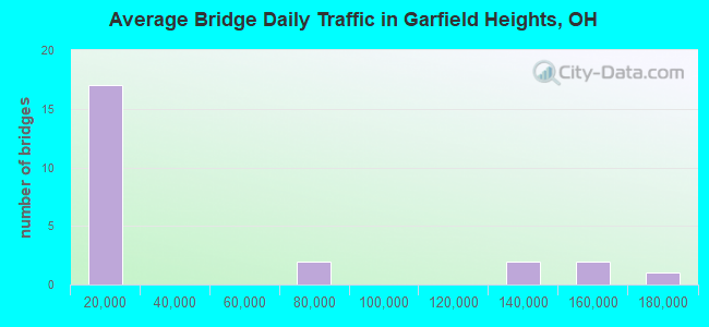
- 1,016,774Total average daily traffic
- 55,196Total average daily truck traffic
- National Bridge Inventory (NBI) Registered Bridges for Garfield Heights
- No street view available for this location
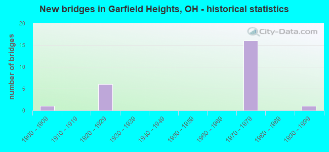
- New bridges - historical statistics
- 11900-1909
- 61920-1929
- 161970-1979
- 11990-1999
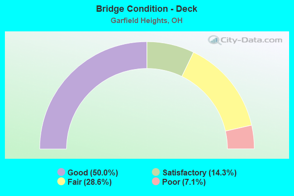
- Bridge Condition - Deck
- 50.0%Good
- 14.3%Satisfactory
- 28.6%Fair
- 7.1%Poor
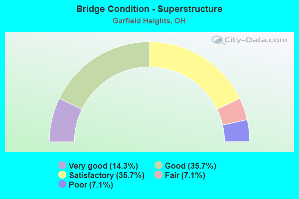
- Bridge Condition - Superstructure
- 14.3%Very good
- 35.7%Good
- 35.7%Satisfactory
- 7.1%Fair
- 7.1%Poor
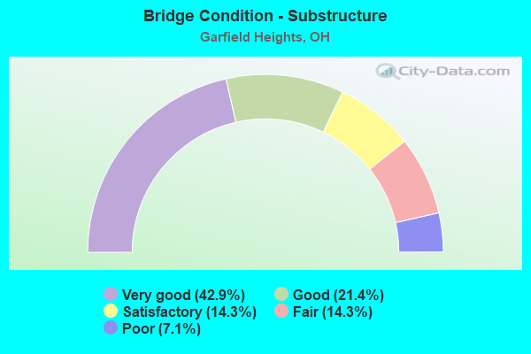
- Bridge Condition - Substructure
- 42.9%Very good
- 21.4%Good
- 14.3%Satisfactory
- 14.3%Fair
- 7.1%Poor
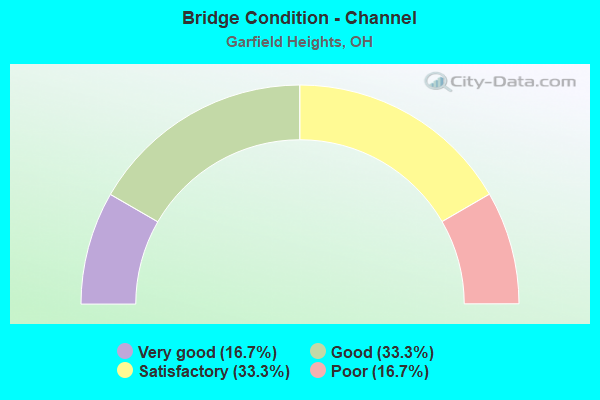
- Bridge Condition - Channel
- 16.7%Very good
- 33.3%Good
- 33.3%Satisfactory
- 16.7%Poor
Find on map >> Show street view
Structure Number: 180174, Location: APPROX 7500FT S E93RD ST. (Lat: 41.437919, Lng: -81.612811), Route carried "on" structure: State highway 14, Year Built: 1928, Status: Open, Structure Length: 1.52m (4.99ft), Average Daily Traffic: 12,155 (year 2015), Truck Traffic: 11%, Average Future Daily Traffic: 16,871 (year 2035), Design Load: H 20, Features Intersected: MILL CREEK
Minimum Vertical Clearance: 30+ m (98+ ft), Kilometerpoint: 9.978, Lanes on structure: 4, Base Highway Network: Yes, Owner: State Highway Agency, Approaching Roadway Width: 14.6m (47.9ft), Skew: 3 degrees, Material/Design: Concrete, Design/Construction: Arch - Deck, Number Of Spans In Main Unit: 1, Length of Maximum Span: 15.2m (49.9ft), Curb or Sidewalk Widths: Left: 2.2m (7.2ft), Right: 2.2m (7.2ft), Curb-To-Curb Width: 14.7m (48.2ft), Out-to-Out Width: 19.0m (62.3ft)
Condition: Deck: Good, Superstructure: Very good, Substructure: Very good, Channel: Good, Operating Rating: 97.2 metric tons, Method Used To Determine Operating Rating: Load Factor (LF) rating reported by rating factor (RF) method using MS18 loading, Inventory Rating: 68.0 metric tons, Method Used To Determine Inventory Rating: Load Factor (LF) rating reported by rating factor (RF) method using MS18 loading, Structural Evaluation: Equal to present desirable criteria, Deck Geometry: High priority of replacement, Waterway Adequacy: Somewhat better than minimum adequacy, Approach Roadway Alignment: Equal to present desirable criteria, Length Of Structure Improvement: 3.05m (10.01ft), Designated Inspection Frequency: Every 24 months, Inspection Date: August 2021, Bridge Improvement Cost: $324,000, Roadway Improvement Cost: $36,000, Total Project Cost: $360,000, Wearing Surface/Protective System: Wearing Surface: Bituminous
Find on map >> Show street view
Structure Number: 1801775, Location: APPROX 1.1 MI S MILES RD. (Lat: 41.433661, Lng: -81.605961), Route carried "on" structure: State highway 14, Year Built: 1928, Status: Open, Structure Length: 1.46m (4.79ft), Average Daily Traffic: 12,155 (year 2015), Truck Traffic: 11%, Average Future Daily Traffic: 16,871 (year 2035), Features Intersected: MILL CREEK
Minimum Vertical Clearance: 30+ m (98+ ft), Kilometerpoint: 10.783, Lanes on structure: 4, Base Highway Network: Yes, Owner: State Highway Agency, Approaching Roadway Width: 14.6m (47.9ft), Material/Design: Concrete, Design/Construction: Arch - Deck, Number Of Spans In Main Unit: 1, Length of Maximum Span: 14.6m (47.9ft), Curb or Sidewalk Widths: Left: 2.4m (7.9ft), Right: 2.1m (6.9ft), Curb-To-Curb Width: 14.7m (48.2ft), Out-to-Out Width: 19.2m (63.0ft)
Condition: Deck: Good, Superstructure: Very good, Substructure: Very good, Channel: Very good, Operating Rating: 97.2 metric tons, Method Used To Determine Operating Rating: Load Factor (LF) rating reported by rating factor (RF) method using MS18 loading, Inventory Rating: 68.0 metric tons, Method Used To Determine Inventory Rating: Load Factor (LF) rating reported by rating factor (RF) method using MS18 loading, Structural Evaluation: Equal to present desirable criteria, Deck Geometry: High priority of replacement, Waterway Adequacy: Equal to present desirable criteria, Approach Roadway Alignment: Equal to present desirable criteria, Length Of Structure Improvement: 2.44m (8.01ft), Designated Inspection Frequency: Every 24 months, Inspection Date: August 2021, Bridge Improvement Cost: $261,000, Roadway Improvement Cost: $29,000, Total Project Cost: $290,000, Wearing Surface/Protective System: Wearing Surface: Bituminous
Find on map >> Show street view
Structure Number: 1801805, Location: APPROX 2MI W CNTY144 (Lat: 41.431981, Lng: -81.602339), Route carried "on" structure: State highway 14, Year Built: 1929, Status: Open, Structure Length: 41.42m (135.89ft), Average Daily Traffic: 12,155 (year 2015), Truck Traffic: 11%, Average Future Daily Traffic: 16,871 (year 2035), Design Load: H 15, Features Intersected: NSC,W&LE RR @ HENRY ST.
Minimum Vertical Clearance: 30+ m (98+ ft), Kilometerpoint: 11.153, Lanes on structure: 4, Base Highway Network: Yes, Owner: State Highway Agency, Approaching Roadway Width: 15.2m (49.9ft), Material/Design: Steel continuous, Design/Construction: Stringer/Multi-beam, Number Of Spans In Main Unit: 9, Number Of Approach Spans: 47, Length of Maximum Span: 19.8m (65.0ft), Curb or Sidewalk Widths: Left: 1.5m (4.9ft), Right: 1.5m (4.9ft), Curb-To-Curb Width: 15.9m (52.2ft), Out-to-Out Width: 19.0m (62.3ft)
Condition: Deck: Poor, Superstructure: Poor, Substructure: Poor, Operating Rating: 61.6 metric tons, Method Used To Determine Operating Rating: Load Factor (LF) rating reported by rating factor (RF) method using MS18 loading, Inventory Rating: 38.9 metric tons, Method Used To Determine Inventory Rating: Load Factor (LF) rating reported by rating factor (RF) method using MS18 loading, Structural Evaluation: Meets minimum limits, Deck Geometry: Meets minimum limits, Underclear: Meets minimum limits, Approach Roadway Alignment: Equal to present desirable criteria, Designated Inspection Frequency: Every 12 months, Critical Feature Inspection Frequency: Every 24 months, Inspection Date: November 2021, Critical Feature Inspection Date: November 2021, Deck Structure Type: Concrete Cast-file-Place, Wearing Surface/Protective System: Wearing Surface: Latex Concrete, Membrane: Epoxy
Find on map >> Show street view
Structure Number: 1812122, Location: .09 MI. E. OF JCT. SR-14 (Lat: 41.425311, Lng: -81.580100), Route carried "on" structure: Ramp Interstate 480, Year Built: 1976, Status: Open, Structure Length: 5.21m (17.09ft), Average Daily Traffic: 5,950 (year 2000), Truck Traffic: 8%, Average Future Daily Traffic: 8,259 (year 2020), Design Load: HS 20+Mod, Features Intersected: 14-IR 480W RMP O MCCRAKN, Facility Carried by Structure: RAMP W.
Minimum Vertical Clearance: 30+ m (98+ ft), Kilometerpoint: 34.810, Lanes on structure: 1, Lanes under structure: 4, Owner: State Highway Agency, Approaching Roadway Width: 7.9m (25.9ft), Skew: 2 degrees, Material/Design: Steel continuous, Design/Construction: Stringer/Multi-beam, Number Of Spans In Main Unit: 3, Length of Maximum Span: 21.0m (68.9ft), Curb-To-Curb Width: 8.1m (26.6ft), Out-to-Out Width: 9.3m (30.5ft)
Condition: Deck: Good, Superstructure: Good, Substructure: Good, Operating Rating: 42.1 metric tons, Method Used To Determine Operating Rating: Load Factor (LF) rating reported by rating factor (RF) method using MS18 loading, Inventory Rating: 32.4 metric tons, Method Used To Determine Inventory Rating: Load Factor (LF) rating reported by rating factor (RF) method using MS18 loading, Structural Evaluation: Better than present minimum criteria, Deck Geometry: Superior to present desirable criteria, Underclear: Meets minimum limits, Approach Roadway Alignment: Equal to present desirable criteria, Designated Inspection Frequency: Every 24 months, Inspection Date: September 2021, Deck Structure Type: Concrete Cast-file-Place, Wearing Surface/Protective System: Wearing Surface: Integral Concrete, Membrane: Built-up
Find on map >> Show street view
Structure Number: 181213, Location: .11 MI. E. OF JCT. SR-14 (Lat: 41.425439, Lng: -81.579731), Route carried "on" structure: Ramp Interstate 480, Year Built: 1976, Status: Open, Structure Length: 4.42m (14.50ft), Average Daily Traffic: 129,126 (year 2010), Truck Traffic: 5%, Average Future Daily Traffic: 179,227 (year 2030), Design Load: HS 20+Mod, Features Intersected: IR480&14RMP OVR MCCRAKEN, Facility Carried by Structure: BEDFORD FREEWAY
Minimum Vertical Clearance: 30+ m (98+ ft), Kilometerpoint: 34.842, Lanes on structure: 3, Lanes under structure: 4, Owner: State Highway Agency, Approaching Roadway Width: 22.6m (74.1ft), Skew: 10 degrees, Material/Design: Steel continuous, Design/Construction: Stringer/Multi-beam, Number Of Spans In Main Unit: 3, Length of Maximum Span: 19.5m (64.0ft), Curb-To-Curb Width: 22.7m (74.5ft), Out-to-Out Width: 23.9m (78.4ft)
Condition: Deck: Good, Superstructure: Good, Substructure: Very good, Operating Rating: 42.1 metric tons, Method Used To Determine Operating Rating: Load Factor (LF) rating reported by rating factor (RF) method using MS18 loading, Inventory Rating: 32.4 metric tons, Method Used To Determine Inventory Rating: Load Factor (LF) rating reported by rating factor (RF) method using MS18 loading, Structural Evaluation: Better than present minimum criteria, Deck Geometry: Superior to present desirable criteria, Underclear: Meets minimum limits, Approach Roadway Alignment: Equal to present desirable criteria, Designated Inspection Frequency: Every 24 months, Inspection Date: September 2021, Deck Structure Type: Concrete Cast-file-Place, Wearing Surface/Protective System: Wearing Surface: Integral Concrete, Membrane: Built-up
Find on map >> Show street view
Structure Number: 1812149, Location: .16 MI. E. OF JCT. SR-14 (Lat: 41.425561, Lng: -81.579019), Route carried "on" structure: Ramp Interstate 480, Year Built: 1976, Status: Open, Structure Length: 7.01m (23.00ft), Average Daily Traffic: 7,490 (year 2001), Truck Traffic: 5%, Average Future Daily Traffic: 10,396 (year 2021), Design Load: HS 20+Mod, Features Intersected: IR480W-14RMPOVR MCCRAKEN, Facility Carried by Structure: RAMP E-N
Minimum Vertical Clearance: 30+ m (98+ ft), Kilometerpoint: 34.923, Lanes on structure: 1, Lanes under structure: 2, Owner: State Highway Agency, Approaching Roadway Width: 12.2m (40.0ft), Skew: 4 degrees, Material/Design: Steel continuous, Design/Construction: Stringer/Multi-beam, Number Of Spans In Main Unit: 3, Length of Maximum Span: 29.0m (95.1ft), Curb-To-Curb Width: 12.4m (40.7ft), Out-to-Out Width: 13.5m (44.3ft)
Condition: Deck: Satisfactory, Superstructure: Satisfactory, Substructure: Very good, Operating Rating: 42.1 metric tons, Method Used To Determine Operating Rating: Load Factor (LF) rating reported by rating factor (RF) method using MS18 loading, Inventory Rating: 32.4 metric tons, Method Used To Determine Inventory Rating: Load Factor (LF) rating reported by rating factor (RF) method using MS18 loading, Structural Evaluation: Equal to present minimum criteria, Deck Geometry: Superior to present desirable criteria, Underclear: Meets minimum limits, Approach Roadway Alignment: Equal to present desirable criteria, Designated Inspection Frequency: Every 12 months, Inspection Date: September 2021, Deck Structure Type: Concrete Cast-file-Place, Wearing Surface/Protective System: Wearing Surface: Integral Concrete, Membrane: Built-up
Find on map >> Show street view
Structure Number: 1812556, Location: 2.0 MI. W. OF JCT. SR-14 (Lat: 41.412181, Lng: -81.615811), Route carried "on" structure: City street E98ST, Year Built: 1977, Status: Open, Structure Length: 12.44m (40.81ft), Average Daily Traffic: 16,576 (year 2015), Truck Traffic: 5%, Average Future Daily Traffic: 23,007 (year 2035), Design Load: HS 20+Mod, Features Intersected: IR-480, Facility Carried by Structure: E. 98TH ST.
Minimum Vertical Clearance: 30+ m (98+ ft), Kilometerpoint: 0.542, Lanes on structure: 4, Lanes under structure: 10, Owner: State Highway Agency, Approaching Roadway Width: 15.9m (52.2ft), Skew: 1 degrees, Material/Design: Steel continuous, Design/Construction: Stringer/Multi-beam, Number Of Spans In Main Unit: 5, Length of Maximum Span: 29.0m (95.1ft), Curb or Sidewalk Widths: Left: 1.5m (4.9ft), Right: 1.5m (4.9ft), Curb-To-Curb Width: 15.9m (52.2ft), Out-to-Out Width: 19.6m (64.3ft)
Condition: Deck: Fair, Superstructure: Satisfactory, Substructure: Fair, Operating Rating: 42.1 metric tons, Method Used To Determine Operating Rating: Load Factor (LF) rating reported by rating factor (RF) method using MS18 loading, Inventory Rating: 32.4 metric tons, Method Used To Determine Inventory Rating: Load Factor (LF) rating reported by rating factor (RF) method using MS18 loading, Structural Evaluation: Somewhat better than minimum adequacy, Deck Geometry: Meets minimum limits, Underclear: High priority of corrective action, Approach Roadway Alignment: Equal to present desirable criteria, Designated Inspection Frequency: Every 12 months, Inspection Date: August 2021, Deck Structure Type: Concrete Cast-file-Place, Wearing Surface/Protective System: Wearing Surface: Integral Concrete, Membrane: Epoxy, Deck Protection: Other
Find on map >> Show street view
Structure Number: 1812564, Location: 1.35 MI. W. OF JCT. SR-14 (Lat: 41.413731, Lng: -81.603650), Route carried "on" structure: County highway C0072, Year Built: 1977, Status: Open, Structure Length: 11.03m (36.19ft), Average Daily Traffic: 18,767 (year 2015), Truck Traffic: 7%, Average Future Daily Traffic: 212,328 (year 2035), Design Load: HS 20+Mod, Features Intersected: IR480, Facility Carried by Structure: TURNEY RD
Minimum Vertical Clearance: 30+ m (98+ ft), Kilometerpoint: 77.265, Lanes on structure: 4, Lanes under structure: 8, Owner: State Highway Agency, Approaching Roadway Width: 15.9m (52.2ft), Skew: 1 degrees, Material/Design: Steel continuous, Design/Construction: Stringer/Multi-beam, Number Of Spans In Main Unit: 5, Length of Maximum Span: 28.3m (92.8ft), Curb or Sidewalk Widths: Left: 1.8m (5.9ft), Right: 1.8m (5.9ft), Curb-To-Curb Width: 15.9m (52.2ft), Out-to-Out Width: 20.2m (66.3ft)
Condition: Deck: Fair, Superstructure: Good, Substructure: Satisfactory, Operating Rating: 42.1 metric tons, Method Used To Determine Operating Rating: Load Factor (LF) rating reported by rating factor (RF) method using MS18 loading, Inventory Rating: 32.4 metric tons, Method Used To Determine Inventory Rating: Load Factor (LF) rating reported by rating factor (RF) method using MS18 loading, Structural Evaluation: Equal to present minimum criteria, Deck Geometry: Meets minimum limits, Underclear: Meets minimum limits, Approach Roadway Alignment: Equal to present desirable criteria, Designated Inspection Frequency: Every 12 months, Inspection Date: August 2021, Deck Structure Type: Concrete Cast-file-Place, Wearing Surface/Protective System: Wearing Surface: Integral Concrete
Find on map >> Show street view
Structure Number: 1812572, Location: .79 MI. W. OF JCT. SR-14 (Lat: 41.417150, Lng: -81.594650), Route carried "on" structure: Interstate 480, Year Built: 1977, Status: Open, Structure Length: 7.96m (26.12ft), Average Daily Traffic: 70,391 (year 2015), Truck Traffic: 5%, Average Future Daily Traffic: 97,703 (year 2035), Design Load: HS 20+Mod, Features Intersected: SR 17 (1697) GRANGER RD.
Minimum Vertical Clearance: 30+ m (98+ ft), Kilometerpoint: 33.394, Lanes on structure: 5, Lanes under structure: 4, Base Highway Network: Yes, Owner: State Highway Agency, Approaching Roadway Width: 20.7m (67.9ft), Skew: 4 degrees, Material/Design: Steel continuous, Design/Construction: Stringer/Multi-beam, Number Of Spans In Main Unit: 3, Length of Maximum Span: 33.5m (109.9ft), Curb-To-Curb Width: 28.3m (92.8ft), Out-to-Out Width: 29.3m (96.1ft)
Condition: Deck: Good, Superstructure: Satisfactory, Substructure: Fair, Operating Rating: 42.1 metric tons, Method Used To Determine Operating Rating: Allowable Stress (AS) rating reported by rating factor (RF) method using MS18 loading, Inventory Rating: 32.4 metric tons, Method Used To Determine Inventory Rating: Allowable Stress (AS) rating reported by rating factor (RF) method using MS18 loading, Structural Evaluation: Somewhat better than minimum adequacy, Deck Geometry: Superior to present desirable criteria, Underclear: High priority of corrective action, Approach Roadway Alignment: Equal to present desirable criteria, Designated Inspection Frequency: Every 12 months, Inspection Date: October 2021, Deck Structure Type: Concrete Cast-file-Place, Wearing Surface/Protective System: Wearing Surface: Integral Concrete, Membrane: Built-up, Deck Protection: Other
Find on map >> Show street view
Structure Number: 181258, Location: .79 MI. W. OF JCT. SR-14 (Lat: 41.417119, Lng: -81.593519), Route carried "on" structure: Interstate 480, Year Built: 1977, Status: Open, Structure Length: 8.38m (27.49ft), Average Daily Traffic: 70,391 (year 2015), Truck Traffic: 5%, Average Future Daily Traffic: 97,703 (year 2035), Design Load: HS 20+Mod, Features Intersected: SR 17 (1704) GRANGER RD.
Minimum Vertical Clearance: 30+ m (98+ ft), Kilometerpoint: 33.394, Lanes on structure: 4, Lanes under structure: 4, Base Highway Network: Yes, Owner: State Highway Agency, Approaching Roadway Width: 20.7m (67.9ft), Skew: 5 degrees, Material/Design: Steel continuous, Design/Construction: Stringer/Multi-beam, Number Of Spans In Main Unit: 3, Length of Maximum Span: 35.4m (116.1ft), Curb-To-Curb Width: 21.7m (71.2ft), Out-to-Out Width: 22.6m (74.1ft)
Condition: Deck: Good, Superstructure: Satisfactory, Substructure: Satisfactory, Operating Rating: 48.6 metric tons, Method Used To Determine Operating Rating: Load Factor (LF) rating reported by rating factor (RF) method using MS18 loading, Inventory Rating: 29.2 metric tons, Method Used To Determine Inventory Rating: Load Factor (LF) rating reported by rating factor (RF) method using MS18 loading, Structural Evaluation: Equal to present minimum criteria, Deck Geometry: Better than present minimum criteria, Underclear: High priority of corrective action, Approach Roadway Alignment: Equal to present desirable criteria, Designated Inspection Frequency: Every 12 months, Inspection Date: October 2021, Deck Structure Type: Concrete Cast-file-Place, Wearing Surface/Protective System: Wearing Surface: Integral Concrete, Membrane: Built-up, Deck Protection: Other
Find on map >> Show street view
Structure Number: 181339, Location: JCT. SR-14 AND I-480 (Lat: 41.424431, Lng: -81.579131), Route carried "on" structure: Ramp Interstate 480, Year Built: 1976, Status: Open, Structure Length: 6.64m (21.78ft), Average Daily Traffic: 129,126 (year 2010), Truck Traffic: 5%, Average Future Daily Traffic: 179,227 (year 2030), Design Load: HS 20+Mod, Features Intersected: IR 480 (RMP TO BROADWAY), Facility Carried by Structure: SR 14 AND RAMPS
Minimum Vertical Clearance: 30+ m (98+ ft), Kilometerpoint: 34.891, Lanes on structure: 3, Lanes under structure: 7, Owner: State Highway Agency, Approaching Roadway Width: 23.8m (78.1ft), Skew: 11 degrees, Material/Design: Steel continuous, Design/Construction: Stringer/Multi-beam, Number Of Spans In Main Unit: 2, Length of Maximum Span: 36.6m (120.1ft), Curb-To-Curb Width: 22.7m (74.5ft), Out-to-Out Width: 23.9m (78.4ft)
Condition: Deck: Satisfactory, Superstructure: Satisfactory, Substructure: Very good, Operating Rating: 42.1 metric tons, Method Used To Determine Operating Rating: Load Factor (LF) rating reported by rating factor (RF) method using MS18 loading, Inventory Rating: 32.4 metric tons, Method Used To Determine Inventory Rating: Load Factor (LF) rating reported by rating factor (RF) method using MS18 loading, Structural Evaluation: Equal to present minimum criteria, Deck Geometry: Superior to present desirable criteria, Underclear: Somewhat better than minimum adequacy, Approach Roadway Alignment: Equal to present desirable criteria, Designated Inspection Frequency: Every 12 months, Inspection Date: September 2021, Deck Structure Type: Concrete Cast-file-Place, Wearing Surface/Protective System: Wearing Surface: Integral Concrete, Membrane: Built-up
Find on map >> Show street view
Structure Number: 1831925, Location: 636 FT W OF BROADWAY RD (Lat: 41.424161, Lng: -81.584411), Route carried "on" structure: County highway 55, Year Built: 1995, Status: Open, Structure Length: 1.71m (5.61ft), Average Daily Traffic: 5,829 (year 2015), Truck Traffic: 5%, Average Future Daily Traffic: 8,091 (year 2035), Design Load: HS 20, Features Intersected: MILL CREEK
Minimum Vertical Clearance: 30+ m (98+ ft), Kilometerpoint: 2.189, Lanes on structure: 2, Owner: County Highway Agency, Approaching Roadway Width: 8.5m (27.9ft), Skew: 1 degrees, Material/Design: Prestressed concrete, Design/Construction: Box Beam or Girders - Multiple, Number Of Spans In Main Unit: 1, Length of Maximum Span: 16.8m (55.1ft), Curb or Sidewalk Widths: Left: 1.5m (4.9ft), Right: 1.5m (4.9ft), Curb-To-Curb Width: 8.5m (27.9ft), Out-to-Out Width: 12.2m (40.0ft)
Condition: Deck: Fair, Superstructure: Fair, Substructure: Very good, Channel: Satisfactory, Operating Rating: 97.2 metric tons, Method Used To Determine Operating Rating: Load Factor (LF) rating reported by rating factor (RF) method using MS18 loading, Inventory Rating: 59.3 metric tons, Method Used To Determine Inventory Rating: Load Factor (LF) rating reported by rating factor (RF) method using MS18 loading, Structural Evaluation: Somewhat better than minimum adequacy, Deck Geometry: High priority of replacement, Waterway Adequacy: Better than present minimum criteria, Approach Roadway Alignment: Equal to present minimum criteria, Designated Inspection Frequency: Every 12 months, Inspection Date: August 2021, Deck Structure Type: Concrete Cast-file-Place, Wearing Surface/Protective System: Wearing Surface: Monolithic Concrete, Deck Protection: Epoxy Coated Reinforcing
Find on map >> Show street view
Structure Number: 1834037, Location: UNDER HENRY ST. BR.#89 (Lat: 41.430850, Lng: -81.600831), Route carried "on" structure: City street 240, Year Built: 1928, Status: Open, Structure Length: 0.75m (2.46ft), Average Daily Traffic: 110 (year 2009), Truck Traffic: 9%, Average Future Daily Traffic: 153 (year 2029), Design Load: HS 15, Features Intersected: MILL CREEK
Minimum Vertical Clearance: 30+ m (98+ ft), Kilometerpoint: 0.982, Lanes on structure: 2, Owner: County Highway Agency, Approaching Roadway Width: 9.1m (29.9ft), Material/Design: Concrete, Design/Construction: Culvert, Number Of Spans In Main Unit: 1, Length of Maximum Span: 7.0m (23.0ft)
Condition: Channel: Good, Culverts: Poor, Operating Rating: 36.0 metric tons, Method Used To Determine Operating Rating: Load and Resistance Factor Rating (LRFR) rating reported by rating factor(RF) method using HL-93 loadings, Inventory Rating: 27.9 metric tons, Method Used To Determine Inventory Rating: Load and Resistance Factor Rating (LRFR) rating reported by rating factor(RF) method using HL-93 loadings, Structural Evaluation: Meets minimum limits, Waterway Adequacy: Superior to present desirable criteria, Approach Roadway Alignment: Equal to present minimum criteria, Designated Inspection Frequency: Every 12 months, Inspection Date: August 2021
Find on map >> Show street view
Structure Number: 1834282, Location: AT BROADWAY ROAD (Lat: 41.430661, Lng: -81.600961), Route carried "on" structure: County highway C0240, Year Built: 1929, Year Reconstructed: 1988, Status: Open, Structure Length: 3.15m (10.33ft), Average Daily Traffic: 12,155 (year 2015), Truck Traffic: 11%, Average Future Daily Traffic: 16,871 (year 2035), Design Load: HS 20+Mod, Features Intersected: MILL CREEK, Facility Carried by Structure: HENRY ST CR 240
Minimum Vertical Clearance: 30+ m (98+ ft), Kilometerpoint: 0.998, Lanes on structure: 3, Owner: County Highway Agency, Approaching Roadway Width: 9.1m (29.9ft), Material/Design: Concrete continuous, Design/Construction: Tee Beam, Number Of Spans In Main Unit: 4, Length of Maximum Span: 7.3m (24.0ft), Curb or Sidewalk Widths: Left: 1.5m (4.9ft), Right: 1.5m (4.9ft), Curb-To-Curb Width: 14.0m (45.9ft), Out-to-Out Width: 17.7m (58.1ft)
Condition: Deck: Fair, Superstructure: Good, Substructure: Good, Operating Rating: 92.0 metric tons, Method Used To Determine Operating Rating: Load Factor (LF) rating reported by rating factor (RF) method using MS18 loading, Inventory Rating: 55.1 metric tons, Method Used To Determine Inventory Rating: Load Factor (LF) rating reported by rating factor (RF) method using MS18 loading, Structural Evaluation: Better than present minimum criteria, Deck Geometry: Somewhat better than minimum adequacy, Approach Roadway Alignment: Equal to present minimum criteria, Designated Inspection Frequency: Every 12 months, Inspection Date: August 2021, Deck Structure Type: Concrete Cast-file-Place, Wearing Surface/Protective System: Wearing Surface: Latex Concrete, Deck Protection: Epoxy Coated Reinforcing
Find on map >> Show street view
Structure Number: 1890808, Location: 1500'E OF GARFIELD PK BLV (Lat: 41.430969, Lng: -81.601550), Route carried "on" structure: Other road CMP, Year Built: 1929, Status: Open, Structure Length: 0.73m (2.40ft), Average Daily Traffic: 2,000 (year 1995), Truck Traffic: 5%, Average Future Daily Traffic: 2,776 (year 2015), Features Intersected: MILL CREEK, Facility Carried by Structure: GARFIELD PARKWAY
Minimum Vertical Clearance: 30+ m (98+ ft), Kilometerpoint: 0.000, Lanes on structure: 2, Owner: Local Park, Forest, or Reservation Agency, Approaching Roadway Width: 9.8m (32.2ft), Material/Design: Concrete, Design/Construction: Culvert, Number Of Spans In Main Unit: 1, Length of Maximum Span: 6.7m (22.0ft)
Condition: Channel: Poor, Culverts: Poor, Operating Rating: 64.8 metric tons, Method Used To Determine Operating Rating: Load Factor (LF) rating reported by rating factor (RF) method using MS18 loading, Inventory Rating: 38.9 metric tons, Method Used To Determine Inventory Rating: Load Factor (LF) rating reported by rating factor (RF) method using MS18 loading, Structural Evaluation: Meets minimum limits, Waterway Adequacy: Superior to present desirable criteria, Approach Roadway Alignment: Equal to present desirable criteria, Designated Inspection Frequency: Every 12 months, Inspection Date: August 2021
Find on map >> Show street view
Structure Number: 189084, Location: 500' E. Garfield Pk Blvd (Lat: 41.433061, Lng: -81.606150), Route carried "on" structure: Other road CMP, Year Built: 1900, Year Reconstructed: 1987, Status: Open, Structure Length: 1.43m (4.69ft), Average Daily Traffic: 2,000 (year 1995), Truck Traffic: 5%, Average Future Daily Traffic: 2,776 (year 2015), Design Load: HS 25 or greater, Features Intersected: Mill Creek, Facility Carried by Structure: Garfield Parkway
Minimum Vertical Clearance: 30+ m (98+ ft), Kilometerpoint: 0.983, Lanes on structure: 2, Owner: Local Park, Forest, or Reservation Agency, Approaching Roadway Width: 9.4m (30.8ft), Material/Design: Prestressed concrete, Design/Construction: Box Beam or Girders - Multiple, Number Of Spans In Main Unit: 1, Length of Maximum Span: 13.4m (44.0ft), Curb or Sidewalk Widths: Left: 2.9m (9.5ft), Right: 3.7m (12.1ft), Curb-To-Curb Width: 8.1m (26.6ft), Out-to-Out Width: 15.9m (52.2ft)
Condition: Deck: Good, Superstructure: Good, Substructure: Good, Channel: Satisfactory, Operating Rating: 71.3 metric tons, Method Used To Determine Operating Rating: Load Factor (LF) rating reported by rating factor (RF) method using MS18 loading, Inventory Rating: 42.1 metric tons, Method Used To Determine Inventory Rating: Load Factor (LF) rating reported by rating factor (RF) method using MS18 loading, Structural Evaluation: Better than present minimum criteria, Deck Geometry: Meets minimum limits, Waterway Adequacy: Equal to present desirable criteria, Approach Roadway Alignment: Equal to present desirable criteria, Designated Inspection Frequency: Every 24 months, Inspection Date: August 2021, Deck Structure Type: Concrete Cast-file-Place, Wearing Surface/Protective System: Wearing Surface: Monolithic Concrete
Find on map >> Show street view
Structure Number: 1812122, Location: .09 MI. E. OF JCT. SR-14 (Lat: 41.425311, Lng: -81.580100), Route carried "under" structure: County highway 55, Year Built: 1976, Structure Length: 0. m, Average Daily Traffic: 9,424 (year 2015), Truck Traffic: 5%, Features Intersected: I-480 RAMP (LANE B-OBS), Facility Carried by Structure: RAMP W.
Minimum Vertical Clearance: 4.50m (14.76ft), Kilometerpoint: 2.462, Lanes on structure: 1, Lanes under structure: 4, Material/Design: Steel continuous, Design/Construction: Stringer/Multi-beam, Length of Maximum Span: 21.0m (68.9ft)
Find on map >> Show street view
Structure Number: 181213, Location: .11 MI. E. OF JCT. SR-14 (Lat: 41.425439, Lng: -81.579731), Route carried "under" structure: County highway 55, Year Built: 1976, Structure Length: 0. m, Average Daily Traffic: 9,424 (year 2015), Truck Traffic: 5%, Features Intersected: IR 480 RAMP, Facility Carried by Structure: BEDFORD FREEWAY
Minimum Vertical Clearance: 4.70m (15.42ft), Kilometerpoint: 2.462, Lanes on structure: 3, Lanes under structure: 4, Material/Design: Steel continuous, Design/Construction: Stringer/Multi-beam, Length of Maximum Span: 19.5m (64.0ft)
Find on map >> Show street view
Structure Number: 1812149, Location: .16 MI. E. OF JCT. SR-14 (Lat: 41.425561, Lng: -81.579019), Route carried "under" structure: County highway 55, Year Built: 1976, Structure Length: 0. m, Average Daily Traffic: 9,424 (year 2015), Truck Traffic: 5%, Features Intersected: I-480 RAMP (LANE OBS-EB), Facility Carried by Structure: RAMP E-N
Minimum Vertical Clearance: 4.55m (14.93ft), Kilometerpoint: 2.462, Lanes on structure: 1, Lanes under structure: 2, Material/Design: Steel continuous, Design/Construction: Stringer/Multi-beam, Length of Maximum Span: 29.0m (95.1ft)
Find on map >> Show street view
Structure Number: 1812556, Location: 2.0 MI. W. OF JCT. SR-14 (Lat: 41.412181, Lng: -81.615811), Route carried "under" structure: Interstate 480, Year Built: 1977, Structure Length: 0. m, Average Daily Traffic: 162,476 (year 2016), Truck Traffic: 5%, Features Intersected: E 98TH ST, Facility Carried by Structure: E. 98TH ST.
Minimum Vertical Clearance: 5.87m (19.26ft), Kilometerpoint: 31.443, Lanes on structure: 4, Lanes under structure: 10, Material/Design: Steel continuous, Design/Construction: Stringer/Multi-beam, Length of Maximum Span: 29.0m (95.1ft)
Find on map >> Show street view
Structure Number: 1812564, Location: 1.35 MI. W. OF JCT. SR-14 (Lat: 41.413731, Lng: -81.603650), Route carried "under" structure: Interstate 480, Year Built: 1977, Structure Length: 0. m, Average Daily Traffic: 152,974 (year 2015), Truck Traffic: 5%, Features Intersected: CR 72 (TURNEY RD), Facility Carried by Structure: TURNEY RD
Minimum Vertical Clearance: 5.67m (18.60ft), Kilometerpoint: 32.493, Lanes on structure: 4, Lanes under structure: 8, Material/Design: Steel continuous, Design/Construction: Stringer/Multi-beam, Length of Maximum Span: 28.3m (92.8ft)
Find on map >> Show street view
Structure Number: 1812572, Location: .79 MI. W. OF JCT. SR-14 (Lat: 41.417150, Lng: -81.594650), Route carried "under" structure: State highway 17, Year Built: 1977, Structure Length: 0. m, Average Daily Traffic: 8,908 (year 2015), Truck Traffic: 10%, Features Intersected: I-480 (CUY-480-2075L), Facility Carried by Structure: IR 480 W.B.
Minimum Vertical Clearance: 4.52m (14.83ft), Kilometerpoint: 27.311, Lanes on structure: 5, Lanes under structure: 4, Material/Design: Steel continuous, Design/Construction: Stringer/Multi-beam, Length of Maximum Span: 33.5m (109.9ft)
Find on map >> Show street view
Structure Number: 181258, Location: .79 MI. W. OF JCT. SR-14 (Lat: 41.417119, Lng: -81.593519), Route carried "under" structure: State highway 17, Year Built: 1977, Structure Length: 0. m, Average Daily Traffic: 8,908 (year 2015), Truck Traffic: 10%, Features Intersected: I-480 (CUY-480-2075R), Facility Carried by Structure: IR 480 E.B.
Minimum Vertical Clearance: 6.35m (20.83ft), Kilometerpoint: 27.423, Lanes on structure: 4, Lanes under structure: 4, Material/Design: Steel continuous, Design/Construction: Stringer/Multi-beam, Length of Maximum Span: 35.4m (116.1ft)
Find on map >> Show street view
Structure Number: 181339, Location: JCT. SR-14 AND I-480 (Lat: 41.424431, Lng: -81.579131), Route carried "under" structure: Interstate 480, Year Built: 1976, Structure Length: 0. m, Average Daily Traffic: 148,860 (year 2016), Truck Traffic: 5%, Features Intersected: BROADWAY AVE (SR14) RAMP, Facility Carried by Structure: SR 14 AND RAMPS
Minimum Vertical Clearance: 4.99m (16.37ft), Kilometerpoint: 34.891, Lanes on structure: 3, Lanes under structure: 7, Material/Design: Steel continuous, Design/Construction: Stringer/Multi-beam, Length of Maximum Span: 36.6m (120.1ft)