Bridge Statistics for Gardner, Illinois (IL)
Condition, Traffic, Stress, Structural Evaluation, Project Costs
- National Bridge Inventory (NBI) Statistics
- 24Number of bridges
- 276ft / 83.7mTotal length
- $828,000Total costs
- 102,375Total average daily traffic
- 23,305Total average daily truck traffic
- National Bridge Inventory (NBI) Registered Bridges for Gardner
- No street view available for this location
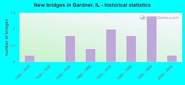
- New bridges - historical statistics
- 11930-1939
- 41950-1959
- 21960-1969
- 51970-1979
- 41980-1989
- 71990-1999
- 12000-2009

- Reconstructed bridges - Historical Statistics
- 21980-1989
- 01990-1999
- 12000-2009
- 12010-2019


- Bridge Condition - Deck
- 15.4%Very good
- 30.8%Good
- 23.1%Satisfactory
- 15.4%Fair
- 15.4%Serious

- Bridge Condition - Superstructure
- 30.8%Very good
- 7.7%Good
- 30.8%Satisfactory
- 15.4%Fair
- 15.4%Serious

- Bridge Condition - Substructure
- 30.8%Very good
- 38.5%Good
- 23.1%Satisfactory
- 7.7%Fair

- Bridge Condition - Channel
- 28.6%Very good
- 57.1%Good
- 14.3%Satisfactory

- Bridge Condition - Culverts
- 80.0%Very good
- 20.0%Fair
Find on map >> Show street view
Structure Number: 320005, Location: 4.1 MI S OF REED RD (Lat: 41.214781, Lng: -88.291047), Route carried "on" structure: Interstate 55, Year Built: 1955, Year Reconstructed: 1993, Status: Open, Structure Length: 7.13m (23.39ft), Average Daily Traffic: 10,700 (year 2021), Truck Traffic: 26%, Average Future Daily Traffic: 12,347 (year 2032), Design Load: HS 20, Features Intersected: MAZON RIVER @ TR 125
Minimum Vertical Clearance: 30+ m (98+ ft), Kilometerpoint: 369.222, Lanes on structure: 2, Lanes under structure: 2, Base Highway Network: Yes, Owner: State Highway Agency, Approaching Roadway Width: 11.6m (38.1ft), Material/Design: Steel continuous, Design/Construction: Stringer/Multi-beam, Number Of Spans In Main Unit: 3, Length of Maximum Span: 27.4m (89.9ft), Curb-To-Curb Width: 11.9m (39.0ft), Out-to-Out Width: 12.9m (42.3ft)
Condition: Deck: Good, Superstructure: Satisfactory, Substructure: Good, Channel: Good, Operating Rating: 97.2 metric tons, Method Used To Determine Operating Rating: Load Factor (LF) rating reported by rating factor (RF) method using MS18 loading, Inventory Rating: 55.1 metric tons, Method Used To Determine Inventory Rating: Load Factor (LF) rating reported by rating factor (RF) method using MS18 loading, Structural Evaluation: Equal to present minimum criteria, Deck Geometry: Equal to present minimum criteria, Underclear: High priority of corrective action, Waterway Adequacy: Equal to present desirable criteria, Approach Roadway Alignment: Equal to present desirable criteria, Designated Inspection Frequency: Every 24 months, Inspection Date: January 2020, Deck Structure Type: Concrete Cast-file-Place, Wearing Surface/Protective System: Deck Protection: Epoxy Coated Reinforcing
Find on map >> Show street view
Structure Number: 320006, Location: 4.1 MI S OF REED RD (Lat: 41.214883, Lng: -88.290911), Route carried "on" structure: Interstate 55, Year Built: 1955, Year Reconstructed: 1993, Status: Open, Structure Length: 7.13m (23.39ft), Average Daily Traffic: 10,700 (year 2021), Truck Traffic: 26%, Average Future Daily Traffic: 12,347 (year 2032), Design Load: HS 20, Features Intersected: MAZON RIVER @ TR 125
Minimum Vertical Clearance: 30+ m (98+ ft), Kilometerpoint: 369.238, Lanes on structure: 2, Lanes under structure: 2, Base Highway Network: Yes, Owner: State Highway Agency, Approaching Roadway Width: 11.6m (38.1ft), Material/Design: Steel continuous, Design/Construction: Stringer/Multi-beam, Number Of Spans In Main Unit: 3, Length of Maximum Span: 27.4m (89.9ft), Curb-To-Curb Width: 11.9m (39.0ft), Out-to-Out Width: 12.9m (42.3ft)
Condition: Deck: Satisfactory, Superstructure: Satisfactory, Substructure: Good, Channel: Good, Operating Rating: 97.2 metric tons, Method Used To Determine Operating Rating: Load Factor (LF) rating reported by rating factor (RF) method using MS18 loading, Inventory Rating: 55.1 metric tons, Method Used To Determine Inventory Rating: Load Factor (LF) rating reported by rating factor (RF) method using MS18 loading, Structural Evaluation: Equal to present minimum criteria, Deck Geometry: Equal to present minimum criteria, Underclear: High priority of corrective action, Waterway Adequacy: Equal to present desirable criteria, Approach Roadway Alignment: Equal to present desirable criteria, Designated Inspection Frequency: Every 24 months, Inspection Date: Febuary 2020, Deck Structure Type: Concrete Cast-file-Place, Wearing Surface/Protective System: Deck Protection: Epoxy Coated Reinforcing
Find on map >> Show street view
Structure Number: 320023, Location: 1.3 M N OF GARDNER (Lat: 41.205989, Lng: -88.284067), Route carried "on" structure: State highway 53, Year Built: 1969, Year Reconstructed: 2009, Status: Open, Structure Length: 6.11m (20.05ft), Average Daily Traffic: 1,450 (year 2021), Truck Traffic: 53%, Average Future Daily Traffic: 1,878 (year 2032), Design Load: HS 20, Features Intersected: MAZON RIVER
Minimum Vertical Clearance: 30+ m (98+ ft), Kilometerpoint: 5.359, Lanes on structure: 2, Base Highway Network: Yes, Owner: State Highway Agency, Approaching Roadway Width: 7.3m (24.0ft), Skew: 1 degrees, Material/Design: Steel continuous, Design/Construction: Stringer/Multi-beam, Number Of Spans In Main Unit: 4, Length of Maximum Span: 16.2m (53.1ft), Curb-To-Curb Width: 13.0m (42.7ft), Out-to-Out Width: 14.0m (45.9ft)
Condition: Deck: Fair, Superstructure: Satisfactory, Substructure: Fair, Channel: Good, Operating Rating: 62.5 metric tons, Method Used To Determine Operating Rating: Load Factor (LF) rating reported by rating factor (RF) method using MS18 loading, Inventory Rating: 37.6 metric tons, Method Used To Determine Inventory Rating: Load Factor (LF) rating reported by rating factor (RF) method using MS18 loading, Structural Evaluation: Somewhat better than minimum adequacy, Deck Geometry: Better than present minimum criteria, Waterway Adequacy: Equal to present minimum criteria, Approach Roadway Alignment: Equal to present desirable criteria, Length Of Structure Improvement: 6.10m (20.01ft), Designated Inspection Frequency: Every 24 months, Inspection Date: January 2020, Bridge Improvement Cost: $552,000, Roadway Improvement Cost: $55,000, Total Project Cost: $828,000, Deck Structure Type: Concrete Cast-file-Place
Find on map >> Show street view
Structure Number: 320078, Location: 3 MI SW OF GARDNER (Lat: 41.155075, Lng: -88.350317), Route carried "on" structure: County highway , Year Built: 1979, Status: Open, Structure Length: 16.20m (53.15ft), Average Daily Traffic: 150 (year 2019), Truck Traffic: 14%, Average Future Daily Traffic: 114 (year 2032), Design Load: HS 15, Features Intersected: I55, RT 66 & ICG RR, Facility Carried by Structure: TR 155
Minimum Vertical Clearance: 30+ m (98+ ft), Kilometerpoint: 16.672, Lanes on structure: 2, Lanes under structure: 8, Owner: State Highway Agency, Approaching Roadway Width: 6.1m (20.0ft), Skew: 3 degrees, Material/Design: Steel continuous, Design/Construction: Stringer/Multi-beam, Number Of Spans In Main Unit: 4, Number Of Approach Spans: 2, Length of Maximum Span: 36.6m (120.1ft), Curb-To-Curb Width: 8.1m (26.6ft), Out-to-Out Width: 9.1m (29.9ft)
Condition: Deck: Satisfactory, Superstructure: Good, Substructure: Very good, Operating Rating: 60.6 metric tons, Method Used To Determine Operating Rating: Load Factor (LF) rating reported by rating factor (RF) method using MS18 loading, Inventory Rating: 36.3 metric tons, Method Used To Determine Inventory Rating: Load Factor (LF) rating reported by rating factor (RF) method using MS18 loading, Structural Evaluation: Better than present minimum criteria, Deck Geometry: Somewhat better than minimum adequacy, Underclear: Equal to present minimum criteria, Approach Roadway Alignment: Equal to present minimum criteria, Designated Inspection Frequency: Every 24 months, Inspection Date: Febuary 2021, Deck Structure Type: Concrete Cast-file-Place, Wearing Surface/Protective System: Wearing Surface: Bituminous, Membrane: Built-up
Find on map >> Show street view
Structure Number: 320092, Location: 4.79 MI S OF REED RD (Lat: 41.206069, Lng: -88.302081), Route carried "on" structure: County highway , Year Built: 1993, Status: Open, Structure Length: 6.83m (22.41ft), Average Daily Traffic: 1,550 (year 2019), Truck Traffic: 4%, Average Future Daily Traffic: 1,536 (year 2032), Design Load: HS 20, Features Intersected: FAI 55, Facility Carried by Structure: TR 182
Minimum Vertical Clearance: 30+ m (98+ ft), Kilometerpoint: 2.527, Lanes on structure: 2, Lanes under structure: 4, Owner: State Highway Agency, Approaching Roadway Width: 8.5m (27.9ft), Skew: 4 degrees, Material/Design: Steel continuous, Design/Construction: Stringer/Multi-beam, Number Of Spans In Main Unit: 2, Number Of Approach Spans: 2, Length of Maximum Span: 33.7m (110.6ft), Curb-To-Curb Width: 9.1m (29.9ft), Out-to-Out Width: 10.1m (33.1ft)
Condition: Deck: Good, Superstructure: Satisfactory, Substructure: Good, Operating Rating: 72.6 metric tons, Method Used To Determine Operating Rating: Load Factor (LF) rating reported by rating factor (RF) method using MS18 loading, Inventory Rating: 39.9 metric tons, Method Used To Determine Inventory Rating: Load Factor (LF) rating reported by rating factor (RF) method using MS18 loading, Structural Evaluation: Equal to present minimum criteria, Deck Geometry: Somewhat better than minimum adequacy, Underclear: Somewhat better than minimum adequacy, Approach Roadway Alignment: Equal to present desirable criteria, Designated Inspection Frequency: Every 24 months, Inspection Date: Febuary 2021, Deck Structure Type: Concrete Cast-file-Place, Wearing Surface/Protective System: Deck Protection: Epoxy Coated Reinforcing
Find on map >> Show street view
Structure Number: 320093, Location: GARD. RD INTERCHANGE (Lat: 41.185586, Lng: -88.321897), Route carried "on" structure: County highway , Year Built: 1997, Status: Open, Structure Length: 6.49m (21.29ft), Average Daily Traffic: 2,400 (year 2019), Truck Traffic: 12%, Average Future Daily Traffic: 1,764 (year 2032), Design Load: HS 20, Features Intersected: I 55, Facility Carried by Structure: FAS 292/GARDNER RD
Minimum Vertical Clearance: 30+ m (98+ ft), Kilometerpoint: 20.615, Lanes on structure: 4, Lanes under structure: 4, Base Highway Network: Yes, Owner: State Highway Agency, Approaching Roadway Width: 18.9m (62.0ft), Skew: 1 degrees, Material/Design: Prestressed concrete, Design/Construction: Stringer/Multi-beam, Number Of Spans In Main Unit: 2, Length of Maximum Span: 24.7m (81.0ft), Curb-To-Curb Width: 18.9m (62.0ft), Out-to-Out Width: 19.8m (65.0ft)
Condition: Deck: Good, Superstructure: Very good, Substructure: Very good, Operating Rating: 76.1 metric tons, Method Used To Determine Operating Rating: Load Factor (LF) rating reported by rating factor (RF) method using MS18 loading, Inventory Rating: 38.6 metric tons, Method Used To Determine Inventory Rating: Load Factor (LF) rating reported by rating factor (RF) method using MS18 loading, Structural Evaluation: Equal to present desirable criteria, Deck Geometry: Equal to present minimum criteria, Underclear: High priority of corrective action, Approach Roadway Alignment: Equal to present desirable criteria, Designated Inspection Frequency: Every 24 months, Inspection Date: Febuary 2021, Deck Structure Type: Concrete Cast-file-Place, Wearing Surface/Protective System: Deck Protection: Epoxy Coated Reinforcing
Find on map >> Show street view
Structure Number: 320096, Location: S. EDGE OF GARDNER (Lat: 41.182114, Lng: -88.314378), Route carried "on" structure: State highway 53, Year Built: 2000, Status: Open, Structure Length: 7.31m (23.98ft), Average Daily Traffic: 1,800 (year 2021), Truck Traffic: 12%, Average Future Daily Traffic: 1,935 (year 2032), Design Load: HS 20, Features Intersected: UNION PACIFIC RR
Minimum Vertical Clearance: 30+ m (98+ ft), Kilometerpoint: 0.982, Lanes on structure: 2, Base Highway Network: Yes, Owner: State Highway Agency, Approaching Roadway Width: 11.4m (37.4ft), Skew: 4 degrees, Material/Design: Steel, Design/Construction: Stringer/Multi-beam, Number Of Spans In Main Unit: 3, Length of Maximum Span: 27.7m (90.9ft), Curb-To-Curb Width: 11.4m (37.4ft), Out-to-Out Width: 12.4m (40.7ft)
Condition: Deck: Good, Superstructure: Very good, Substructure: Good, Operating Rating: 69.7 metric tons, Method Used To Determine Operating Rating: Load Factor (LF) rating reported by rating factor (RF) method using MS18 loading, Inventory Rating: 41.8 metric tons, Method Used To Determine Inventory Rating: Load Factor (LF) rating reported by rating factor (RF) method using MS18 loading, Structural Evaluation: Better than present minimum criteria, Deck Geometry: Equal to present minimum criteria, Underclear: Equal to present desirable criteria, Approach Roadway Alignment: Equal to present minimum criteria, Designated Inspection Frequency: Every 48 months, Inspection Date: January 2018, Deck Structure Type: Concrete Cast-file-Place, Wearing Surface/Protective System: Deck Protection: Epoxy Coated Reinforcing
Find on map >> Show street view
Structure Number: 323235, Location: 0.04 MI N TR 109B (Lat: 41.242800, Lng: -88.341858), Route carried "on" structure: County highway , Year Built: 1987, Status: Open, Structure Length: 6.80m (22.31ft), Average Daily Traffic: 300 (year 2019), Truck Traffic: 16%, Average Future Daily Traffic: 313 (year 2032), Design Load: HS 20, Features Intersected: MAZON RIVER, Facility Carried by Structure: GORMAN RD CH 10
Minimum Vertical Clearance: 30+ m (98+ ft), Kilometerpoint: 4.844, Lanes on structure: 2, Owner: County Highway Agency, Approaching Roadway Width: 7.9m (25.9ft), Skew: 1 degrees, Material/Design: Steel continuous, Design/Construction: Stringer/Multi-beam, Number Of Spans In Main Unit: 3, Length of Maximum Span: 25.6m (84.0ft), Curb-To-Curb Width: 7.9m (25.9ft), Out-to-Out Width: 8.1m (26.6ft)
Condition: Deck: Satisfactory, Superstructure: Fair, Substructure: Satisfactory, Channel: Good, Operating Rating: 63.2 metric tons, Method Used To Determine Operating Rating: Load Factor (LF) rating reported by rating factor (RF) method using MS18 loading, Inventory Rating: 37.9 metric tons, Method Used To Determine Inventory Rating: Load Factor (LF) rating reported by rating factor (RF) method using MS18 loading, Structural Evaluation: Somewhat better than minimum adequacy, Deck Geometry: Somewhat better than minimum adequacy, Waterway Adequacy: Equal to present desirable criteria, Approach Roadway Alignment: Equal to present desirable criteria, Designated Inspection Frequency: Every 24 months, Inspection Date: October 2020, Deck Structure Type: Concrete Cast-file-Place
Find on map >> Show street view
Structure Number: 32325, Location: 0.4 MI E OF TYNAN RD (Lat: 41.228022, Lng: -88.362019), Route carried "on" structure: County highway , Year Built: 1963, Status: Posted for load, Structure Length: 1.28m (4.20ft), Average Daily Traffic: 1,450 (year 2019), Truck Traffic: 6%, Average Future Daily Traffic: 1,252 (year 2032), Design Load: HS 15, Features Intersected: CREEK, Facility Carried by Structure: BRACEVILLE RD CH C
Minimum Vertical Clearance: 30+ m (98+ ft), Kilometerpoint: 20.470, Lanes on structure: 2, Owner: County Highway Agency, Approaching Roadway Width: 9.8m (32.2ft), Material/Design: Prestressed concrete, Design/Construction: Box Beam or Girders - Multiple, Number Of Spans In Main Unit: 1, Length of Maximum Span: 11.9m (39.0ft), Curb-To-Curb Width: 7.3m (24.0ft), Out-to-Out Width: 7.9m (25.9ft)
Condition: Deck: Serious, Superstructure: Serious, Substructure: Good, Channel: Satisfactory, Operating Rating: 30.5 metric tons, Method Used To Determine Operating Rating: Load Factor (LF) rating reported by rating factor (RF) method using MS18 loading, Inventory Rating: 10.7 metric tons, Method Used To Determine Inventory Rating: Load Factor (LF) rating reported by rating factor (RF) method using MS18 loading, Structural Evaluation: High priority of corrective action, Deck Geometry: Meets minimum limits, Waterway Adequacy: Equal to present minimum criteria, Approach Roadway Alignment: Equal to present desirable criteria, Bridge Posting: Required (Relationship of Operating Rating to Maximum Legal Load: > 39.9% below), Designated Inspection Frequency: Every 24 months, Other Special Inspection Frequency: Every 12 months, Inspection Date: October 2020, Other Special Inspection Date: January 2022, Deck Structure Type: Concrete Precast Panels, Wearing Surface/Protective System: Wearing Surface: Bituminous
Find on map >> Show street view
Structure Number: 32326, Location: 0.2MI E at Gorman Rd (Lat: 41.228508, Lng: -88.337467), Route carried "on" structure: County highway , Year Built: 1970, Year Reconstructed: 2019, Status: Open, Structure Length: 6.88m (22.57ft), Average Daily Traffic: 1,450 (year 2019), Truck Traffic: 6%, Average Future Daily Traffic: 1,252 (year 2032), Design Load: HS 25 or greater, Features Intersected: MAZON RIVER, Facility Carried by Structure: FAS-272 Braceville
Minimum Vertical Clearance: 30+ m (98+ ft), Kilometerpoint: 22.562, Lanes on structure: 2, Owner: County Highway Agency, Approaching Roadway Width: 9.8m (32.2ft), Material/Design: Steel continuous, Design/Construction: Stringer/Multi-beam, Number Of Spans In Main Unit: 3, Length of Maximum Span: 25.9m (85.0ft), Curb-To-Curb Width: 8.5m (27.9ft), Out-to-Out Width: 8.5m (27.9ft)
Condition: Deck: Very good, Superstructure: Very good, Substructure: Very good, Channel: Very good, Operating Rating: 58.6 metric tons, Method Used To Determine Operating Rating: Load and Resistance Factor Rating (LRFR) rating reported by rating factor(RF) method using HL-93 loadings, Inventory Rating: 45.4 metric tons, Method Used To Determine Inventory Rating: Load and Resistance Factor Rating (LRFR) rating reported by rating factor(RF) method using HL-93 loadings, Structural Evaluation: Equal to present desirable criteria, Deck Geometry: Somewhat better than minimum adequacy, Waterway Adequacy: Superior to present desirable criteria, Approach Roadway Alignment: Equal to present desirable criteria, Designated Inspection Frequency: Every 48 months, Inspection Date: October 2021, Deck Structure Type: Concrete Cast-file-Place
Find on map >> Show street view
Structure Number: 3233, Location: 0.1 MI W WOODS ROAD (Lat: 41.184008, Lng: -88.379650), Route carried "on" structure: County highway , Year Built: 1934, Status: Open, Structure Length: 0.91m (2.99ft), Average Daily Traffic: 1,550 (year 2019), Truck Traffic: 13%, Average Future Daily Traffic: 1,309 (year 2032), Features Intersected: WOODS RUN, Facility Carried by Structure: GARDNER Rd/FAS 292
Minimum Vertical Clearance: 30+ m (98+ ft), Kilometerpoint: 15.787, Lanes on structure: 2, Owner: County Highway Agency, Approaching Roadway Width: 9.1m (29.9ft), Material/Design: Concrete, Design/Construction: Slab, Number Of Spans In Main Unit: 1, Length of Maximum Span: 8.8m (28.9ft), Curb-To-Curb Width: 9.1m (29.9ft), Out-to-Out Width: 10.1m (33.1ft)
Condition: Deck: Fair, Superstructure: Fair, Substructure: Satisfactory, Channel: Good, Operating Rating: 45.7 metric tons, Method Used To Determine Operating Rating: Load Factor (LF) rating reported by rating factor (RF) method using MS18 loading, Inventory Rating: 27.2 metric tons, Method Used To Determine Inventory Rating: Load Factor (LF) rating reported by rating factor (RF) method using MS18 loading, Structural Evaluation: Somewhat better than minimum adequacy, Deck Geometry: Somewhat better than minimum adequacy, Waterway Adequacy: Somewhat better than minimum adequacy, Approach Roadway Alignment: Equal to present desirable criteria, Designated Inspection Frequency: Every 24 months, Inspection Date: October 2020, Deck Structure Type: Concrete Cast-file-Place, Wearing Surface/Protective System: Wearing Surface: Bituminous
Find on map >> Show street view
Structure Number: 323331, Location: 0.67 MI E GORMAN RD (Lat: 41.185467, Lng: -88.326600), Route carried "on" structure: County highway , Year Built: 1999, Status: Open, Structure Length: 0.92m (3.02ft), Average Daily Traffic: 2,400 (year 2019), Truck Traffic: 12%, Average Future Daily Traffic: 1,764 (year 2032), Design Load: HS 20, Features Intersected: TRIB E FK MAZON RIV., Facility Carried by Structure: FAS 292/GARDNER RD
Minimum Vertical Clearance: 30+ m (98+ ft), Kilometerpoint: 20.229, Lanes on structure: 2, Owner: County Highway Agency, Approaching Roadway Width: 12.2m (40.0ft), Skew: 3 degrees, Material/Design: Concrete continuous, Design/Construction: Culvert, Number Of Spans In Main Unit: 2, Length of Maximum Span: 3.7m (12.1ft)
Condition: Channel: Very good, Culverts: Very good, Operating Rating: 61.6 metric tons, Method Used To Determine Operating Rating: Load Factor (LF) rating reported by rating factor (RF) method using MS18 loading, Inventory Rating: 37.6 metric tons, Method Used To Determine Inventory Rating: Load Factor (LF) rating reported by rating factor (RF) method using MS18 loading, Structural Evaluation: Equal to present desirable criteria, Waterway Adequacy: Equal to present desirable criteria, Approach Roadway Alignment: Equal to present desirable criteria, Designated Inspection Frequency: Every 48 months, Inspection Date: October 2018, Deck Structure Type: Concrete Cast-file-Place, Wearing Surface/Protective System: Wearing Surface: Other
Find on map >> Show street view
Structure Number: 325026, Location: .27 MI E TYNAN ROAD (Lat: 41.220706, Lng: -88.364908), Route carried "on" structure: County highway , Year Built: 1981, Status: Open, Structure Length: 0.74m (2.43ft), Average Daily Traffic: 50 (year 2019), Average Future Daily Traffic: 28 (year 2032), Features Intersected: TRIB E FK MAZON RIV, Facility Carried by Structure: TR 119 BOOTH ROAD
Minimum Vertical Clearance: 30+ m (98+ ft), Kilometerpoint: 0.435, Lanes on structure: 2, Owner: Town or Township Highway Agency, Approaching Roadway Width: 7.3m (24.0ft), Material/Design: Steel, Design/Construction: Culvert, Number Of Spans In Main Unit: 2, Length of Maximum Span: 3.4m (11.2ft), Curb-To-Curb Width: 7.3m (24.0ft), Out-to-Out Width: 7.3m (24.0ft)
Condition: Channel: Satisfactory, Culverts: Fair, Operating Rating: 71.6 metric tons, Method Used To Determine Operating Rating: Load Factor (LF) rating reported by rating factor (RF) method using MS18 loading, Inventory Rating: 68.7 metric tons, Method Used To Determine Inventory Rating: Load Factor (LF) rating reported by rating factor (RF) method using MS18 loading, Structural Evaluation: Somewhat better than minimum adequacy, Deck Geometry: Equal to present minimum criteria, Waterway Adequacy: Equal to present minimum criteria, Approach Roadway Alignment: Better than present minimum criteria, Designated Inspection Frequency: Every 24 months, Inspection Date: October 2020, Deck Structure Type: Concrete Cast-file-Place
Find on map >> Show street view
Structure Number: 325121, Location: 0.91 MI S OF FAS 289 (Lat: 41.216067, Lng: -88.302506), Route carried "on" structure: County highway , Year Built: 1977, Status: Open, Structure Length: 4.85m (15.91ft), Average Daily Traffic: 1,550 (year 2019), Truck Traffic: 4%, Average Future Daily Traffic: 1,935 (year 2032), Design Load: HS 20, Features Intersected: EAST FK MAZON RIVER, Facility Carried by Structure: CARBON HILL RD TR1
Minimum Vertical Clearance: 30+ m (98+ ft), Kilometerpoint: 1.464, Lanes on structure: 2, Owner: County Highway Agency, Approaching Roadway Width: 8.5m (27.9ft), Material/Design: Prestressed concrete, Design/Construction: Box Beam or Girders - Multiple, Number Of Spans In Main Unit: 2, Length of Maximum Span: 23.5m (77.1ft), Curb-To-Curb Width: 8.7m (28.5ft), Out-to-Out Width: 9.4m (30.8ft)
Condition: Deck: Serious, Superstructure: Serious, Substructure: Satisfactory, Channel: Good, Operating Rating: 15.2 metric tons, Method Used To Determine Operating Rating: Load Factor (LF) rating reported by rating factor (RF) method using MS18 loading, Inventory Rating: 6.5 metric tons, Method Used To Determine Inventory Rating: Load Factor (LF) rating reported by rating factor (RF) method using MS18 loading, Structural Evaluation: High priority of corrective action, Deck Geometry: Somewhat better than minimum adequacy, Waterway Adequacy: Equal to present desirable criteria, Approach Roadway Alignment: Equal to present minimum criteria, Bridge Posting: Required (Relationship of Operating Rating to Maximum Legal Load: > 39.9% below), Designated Inspection Frequency: Every 24 months, Inspection Date: October 2020, Deck Structure Type: Concrete Precast Panels, Wearing Surface/Protective System: Wearing Surface: Bituminous
Find on map >> Show street view
Structure Number: 325706, Location: .75 MI E GORMAN ROAD (Lat: 41.192739, Lng: -88.325850), Route carried "on" structure: City street , Year Built: 1983, Status: Open, Structure Length: 1.62m (5.31ft), Average Daily Traffic: 50 (year 2019), Truck Traffic: 20%, Average Future Daily Traffic: 57 (year 2032), Design Load: HS 20, Features Intersected: TRIB E FK MAZON RIV, Facility Carried by Structure: HOWLAND RD/MS 2020
Minimum Vertical Clearance: 30+ m (98+ ft), Kilometerpoint: 1.207, Lanes on structure: 2, Owner: City or Municipal Highway Agency, Approaching Roadway Width: 8.5m (27.9ft), Material/Design: Prestressed concrete, Design/Construction: Box Beam or Girders - Multiple, Number Of Spans In Main Unit: 1, Length of Maximum Span: 15.8m (51.8ft), Curb-To-Curb Width: 8.0m (26.2ft), Out-to-Out Width: 8.2m (26.9ft)
Condition: Deck: Very good, Superstructure: Very good, Substructure: Very good, Channel: Good, Operating Rating: 44.4 metric tons, Method Used To Determine Operating Rating: Assigned rating based on Load Factor Design (LFD) reported by rating factor (RF) using MS18 loading, Inventory Rating: 32.4 metric tons, Method Used To Determine Inventory Rating: Assigned rating based on Load Factor Design (LFD) reported by rating factor (RF) using MS18 loading, Structural Evaluation: Equal to present desirable criteria, Deck Geometry: Equal to present minimum criteria, Waterway Adequacy: Equal to present desirable criteria, Approach Roadway Alignment: Equal to present desirable criteria, Designated Inspection Frequency: Every 48 months, Inspection Date: October 2018, Deck Structure Type: Concrete Precast Panels
Find on map >> Show street view
Structure Number: 325716, Location: .42 MI S. GARDNER RD (Lat: 41.184439, Lng: -88.359061), Route carried "on" structure: County highway , Year Built: 1989, Status: Open, Structure Length: 0.65m (2.13ft), Average Daily Traffic: 50 (year 2019), Truck Traffic: 20%, Average Future Daily Traffic: 28 (year 2032), Design Load: HS 20, Features Intersected: TR1B W. FK MAZON RIV, Facility Carried by Structure: FILMAN RD TR-142
Minimum Vertical Clearance: 30+ m (98+ ft), Kilometerpoint: 4.844, Lanes on structure: 2, Owner: Town or Township Highway Agency, Approaching Roadway Width: 7.9m (25.9ft), Skew: 1 degrees, Material/Design: Concrete continuous, Design/Construction: Culvert, Number Of Spans In Main Unit: 2, Length of Maximum Span: 2.9m (9.5ft), Curb-To-Curb Width: 7.9m (25.9ft), Out-to-Out Width: 8.5m (27.9ft)
Condition: Channel: Very good, Culverts: Very good, Operating Rating: 67.1 metric tons, Method Used To Determine Operating Rating: Load Factor (LF) rating reported by rating factor (RF) method using MS18 loading, Inventory Rating: 40.2 metric tons, Method Used To Determine Inventory Rating: Load Factor (LF) rating reported by rating factor (RF) method using MS18 loading, Structural Evaluation: Equal to present desirable criteria, Deck Geometry: Equal to present minimum criteria, Waterway Adequacy: Equal to present desirable criteria, Approach Roadway Alignment: Equal to present desirable criteria, Designated Inspection Frequency: Every 48 months, Inspection Date: October 2018, Deck Structure Type: Concrete Cast-file-Place
Find on map >> Show street view
Structure Number: 325741, Location: SEC18 T31N R8E 3RD (Lat: 41.168164, Lng: -88.339094), Route carried "on" structure: County highway , Year Built: 1998, Status: Open, Structure Length: 0.96m (3.15ft), Average Daily Traffic: 50 (year 2019), Truck Traffic: 26%, Average Future Daily Traffic: 142 (year 2032), Design Load: HS 20, Features Intersected: TRIB E FORK MAZON RV, Facility Carried by Structure: TR 152 GORMAN RD
Minimum Vertical Clearance: 30+ m (98+ ft), Kilometerpoint: 1.996, Lanes on structure: 2, Owner: Town or Township Highway Agency, Approaching Roadway Width: 7.9m (25.9ft), Skew: 3 degrees, Material/Design: Concrete continuous, Design/Construction: Culvert, Number Of Spans In Main Unit: 2, Length of Maximum Span: 3.7m (12.1ft), Curb-To-Curb Width: 7.9m (25.9ft), Out-to-Out Width: 8.5m (27.9ft)
Condition: Channel: Good, Culverts: Very good, Operating Rating: 64.2 metric tons, Method Used To Determine Operating Rating: Load Factor (LF) rating reported by rating factor (RF) method using MS18 loading, Inventory Rating: 38.6 metric tons, Method Used To Determine Inventory Rating: Load Factor (LF) rating reported by rating factor (RF) method using MS18 loading, Structural Evaluation: Equal to present desirable criteria, Deck Geometry: Equal to present minimum criteria, Waterway Adequacy: Equal to present desirable criteria, Approach Roadway Alignment: Equal to present desirable criteria, Designated Inspection Frequency: Every 48 months, Inspection Date: October 2018, Deck Structure Type: Concrete Cast-file-Place, Wearing Surface/Protective System: Deck Protection: Epoxy Coated Reinforcing
Find on map >> Show street view
Structure Number: 32575, Location: 0.12 MI N/GARDNER RD (Lat: 41.186619, Lng: -88.326119), Route carried "on" structure: City street , Year Built: 1997, Status: Open, Structure Length: 0.92m (3.02ft), Average Daily Traffic: 75 (year 2019), Average Future Daily Traffic: 1,009 (year 2035), Design Load: HS 20, Features Intersected: TRIB TO MAZON RIVER, Facility Carried by Structure: LUTZ RD/MS 6100
Minimum Vertical Clearance: 30+ m (98+ ft), Kilometerpoint: 1.979, Lanes on structure: 2, Owner: City or Municipal Highway Agency, Approaching Roadway Width: 11.0m (36.1ft), Skew: 3 degrees, Material/Design: Concrete, Design/Construction: Culvert, Number Of Spans In Main Unit: 2, Length of Maximum Span: 4.5m (14.8ft)
Condition: Channel: Very good, Culverts: Very good, Operating Rating: 48.3 metric tons, Method Used To Determine Operating Rating: Load Factor (LF) rating reported by rating factor (RF) method using MS18 loading, Inventory Rating: 28.8 metric tons, Method Used To Determine Inventory Rating: Load Factor (LF) rating reported by rating factor (RF) method using MS18 loading, Structural Evaluation: Better than present minimum criteria, Waterway Adequacy: Superior to present desirable criteria, Approach Roadway Alignment: Equal to present desirable criteria, Designated Inspection Frequency: Every 24 months, Inspection Date: November 2020, Deck Structure Type: Concrete Cast-file-Place
Find on map >> Show street view
Structure Number: 320005, Location: 4.1 MI S OF REED RD (Lat: 41.215150, Lng: -88.290561), Route carried "under" structure: County highway , Year Built: 1955, Structure Length: 0. m, Average Daily Traffic: 50 (year 2019), Features Intersected: MAZON RIVER @ TR 125, Facility Carried by Structure: FAI 55 NB
Minimum Vertical Clearance: 3.25m (10.66ft), Kilometerpoint: 0.080, Lanes on structure: 2, Lanes under structure: 2, Material/Design: Steel continuous, Design/Construction: Stringer/Multi-beam, Length of Maximum Span: 27.4m (89.9ft)
Find on map >> Show street view
Structure Number: 320006, Location: 4.1 MI S OF REED RD (Lat: 41.215267, Lng: -88.290733), Route carried "under" structure: County highway , Year Built: 1955, Structure Length: 0. m, Average Daily Traffic: 50 (year 2019), Features Intersected: MAZON RIVER @ TR 125, Facility Carried by Structure: FAI 55 SB
Minimum Vertical Clearance: 3.25m (10.66ft), Kilometerpoint: 0.048, Lanes on structure: 2, Lanes under structure: 2, Material/Design: Steel continuous, Design/Construction: Stringer/Multi-beam, Length of Maximum Span: 27.4m (89.9ft)
Find on map >> Show street view
Structure Number: 320078, Location: 3 MI SW OF GARDNER (Lat: 41.155075, Lng: -88.350317), Route carried "under" structure: Interstate 55, Year Built: 1979, Structure Length: 0. m, Average Daily Traffic: 20,600 (year 2021), Truck Traffic: 21%, Features Intersected: I55, RT 66 & ICG RR
Minimum Vertical Clearance: 6.65m (21.82ft), Kilometerpoint: 360.741, Lanes on structure: 2, Lanes under structure: 6, Material/Design: Steel continuous, Design/Construction: Stringer/Multi-beam, Length of Maximum Span: 36.6m (120.1ft)
Find on map >> Show street view
Structure Number: 320078, Location: 3 MI SW OF GARDNER (Lat: 41.155011, Lng: -88.349936), Route carried "under" structure: County highway , Year Built: 1979, Structure Length: 0. m, Average Daily Traffic: 1,150 (year 2021), Truck Traffic: 11%, Features Intersected: I55, RT 66 & ICG RR, Facility Carried by Structure: TR 155
Minimum Vertical Clearance: 5.49m (18.01ft), Kilometerpoint: 7.226, Lanes on structure: 2, Lanes under structure: 2, Material/Design: Steel continuous, Design/Construction: Stringer/Multi-beam, Length of Maximum Span: 36.6m (120.1ft)
Find on map >> Show street view
Structure Number: 320092, Location: 4.79 MI S OF REED RD (Lat: 41.206069, Lng: -88.302081), Route carried "under" structure: Interstate 55, Year Built: 1993, Structure Length: 0. m, Average Daily Traffic: 21,400 (year 2021), Truck Traffic: 26%, Features Intersected: FAI 55, Facility Carried by Structure: TR 182
Minimum Vertical Clearance: 4.95m (16.24ft), Kilometerpoint: 367.886, Lanes on structure: 2, Lanes under structure: 4, Material/Design: Steel continuous, Design/Construction: Stringer/Multi-beam, Length of Maximum Span: 33.7m (110.6ft)
Find on map >> Show street view
Structure Number: 320093, Location: GARD. RD INTERCHANGE (Lat: 41.185589, Lng: -88.321656), Route carried "under" structure: Interstate 55, Year Built: 1997, Structure Length: 0. m, Average Daily Traffic: 21,400 (year 2021), Truck Traffic: 26%, Features Intersected: I 55, Facility Carried by Structure: FAS 292/GARDNER RD
Minimum Vertical Clearance: 5.08m (16.67ft), Kilometerpoint: 365.021, Lanes on structure: 4, Lanes under structure: 4, Material/Design: Prestressed concrete, Design/Construction: Stringer/Multi-beam, Length of Maximum Span: 24.7m (81.0ft)