Bridge Statistics for Gambrills, Maryland (MD)
Condition, Traffic, Stress, Structural Evaluation, Project Costs
- National Bridge Inventory (NBI) Statistics
- 21Number of bridges
- 194ft / 59.4mTotal length
- 981,066Total average daily traffic
- 70,003Total average daily truck traffic
- National Bridge Inventory (NBI) Registered Bridges for Gambrills
- No street view available for this location
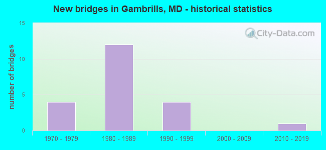
- New bridges - historical statistics
- 41970-1979
- 121980-1989
- 41990-1999
- 12010-2019


- Bridge Condition - Deck
- 54.5%Good
- 45.5%Satisfactory

- Bridge Condition - Superstructure
- 81.8%Good
- 18.2%Satisfactory

- Bridge Condition - Substructure
- 9.1%Very good
- 45.5%Good
- 45.5%Satisfactory

- Bridge Condition - Channel
- 66.7%Very good
- 33.3%Satisfactory
Find on map >> Show street view
Structure Number: 100000020076011, Location: 0.81 MILE NORTH OF MD 3 (Lat: 39.080711, Lng: -76.626667), Route carried "on" structure: Interstate 97, Year Built: 1991, Status: Open, Structure Length: 6.98m (22.90ft), Average Daily Traffic: 102,300 (year 2009), Truck Traffic: 8%, Average Future Daily Traffic: 61,916 (year 2026), Design Load: HS 20, Features Intersected: SEVERN RUN
Minimum Vertical Clearance: 30+ m (98+ ft), Kilometerpoint: 13.966, Lanes on structure: 3, Base Highway Network: Yes, Owner: State Highway Agency, Approaching Roadway Width: 17.1m (56.1ft), Material/Design: Steel continuous, Design/Construction: Stringer/Multi-beam, Number Of Spans In Main Unit: 3, Length of Maximum Span: 26.5m (86.9ft), Curb-To-Curb Width: 17.1m (56.1ft), Out-to-Out Width: 18.3m (60.0ft)
Condition: Deck: Satisfactory, Superstructure: Good, Substructure: Good, Channel: Very good, Operating Rating: 69.4 metric tons, Method Used To Determine Operating Rating: Load Factor (LF), Inventory Rating: 41.7 metric tons, Method Used To Determine Inventory Rating: Load Factor (LF), Structural Evaluation: Better than present minimum criteria, Deck Geometry: Equal to present minimum criteria, Waterway Adequacy: Equal to present desirable criteria, Approach Roadway Alignment: Equal to present desirable criteria, Designated Inspection Frequency: Every 24 months, Inspection Date: September 2021, Deck Structure Type: Concrete Cast-file-Place, Wearing Surface/Protective System: Wearing Surface: Integral Concrete, Deck Protection: Epoxy Coated Reinforcing
Find on map >> Show street view
Structure Number: 100000020076012, Location: 0.81 MILE NORTH OF MD 3 (Lat: 39.081383, Lng: -76.626728), Route carried "on" structure: Interstate 97, Year Built: 1991, Status: Open, Structure Length: 6.98m (22.90ft), Average Daily Traffic: 102,300 (year 2009), Truck Traffic: 8%, Average Future Daily Traffic: 61,916 (year 2026), Design Load: HS 20+Mod, Features Intersected: SEVERN RUN
Minimum Vertical Clearance: 30+ m (98+ ft), Kilometerpoint: 13.966, Lanes on structure: 3, Base Highway Network: Yes, Owner: State Highway Agency, Approaching Roadway Width: 17.1m (56.1ft), Material/Design: Steel continuous, Design/Construction: Stringer/Multi-beam, Number Of Spans In Main Unit: 3, Length of Maximum Span: 26.5m (86.9ft), Curb-To-Curb Width: 17.1m (56.1ft), Out-to-Out Width: 18.3m (60.0ft)
Condition: Deck: Satisfactory, Superstructure: Good, Substructure: Good, Channel: Very good, Operating Rating: 69.4 metric tons, Method Used To Determine Operating Rating: Load Factor (LF), Inventory Rating: 41.7 metric tons, Method Used To Determine Inventory Rating: Load Factor (LF), Structural Evaluation: Better than present minimum criteria, Deck Geometry: Equal to present minimum criteria, Waterway Adequacy: Equal to present desirable criteria, Approach Roadway Alignment: Equal to present desirable criteria, Designated Inspection Frequency: Every 24 months, Inspection Date: September 2021, Deck Structure Type: Concrete Cast-file-Place, Wearing Surface/Protective System: Wearing Surface: Integral Concrete, Deck Protection: Epoxy Coated Reinforcing
Find on map >> Show street view
Structure Number: 10000002009601, Location: 0.35 MILE NORTH OF IS 97 (Lat: 39.065447, Lng: -76.644864), Route carried "on" structure: State highway 32, Year Built: 1970, Status: Open, Structure Length: 5.36m (17.59ft), Average Daily Traffic: 39,092 (year 2009), Truck Traffic: 8%, Average Future Daily Traffic: 58,638 (year 2029), Design Load: HS 20, Features Intersected: MD 3 SBR
Minimum Vertical Clearance: 30+ m (98+ ft), Kilometerpoint: 1.239, Lanes on structure: 2, Lanes under structure: 3, Base Highway Network: Yes, Owner: State Highway Agency, Approaching Roadway Width: 15.5m (50.9ft), Skew: 1 degrees, Material/Design: Steel, Design/Construction: Stringer/Multi-beam, Number Of Spans In Main Unit: 3, Length of Maximum Span: 25.0m (82.0ft), Curb-To-Curb Width: 15.4m (50.5ft), Out-to-Out Width: 16.6m (54.5ft)
Condition: Deck: Satisfactory, Superstructure: Satisfactory, Substructure: Satisfactory, Operating Rating: 59.9 metric tons, Method Used To Determine Operating Rating: Load Factor (LF), Inventory Rating: 35.8 metric tons, Method Used To Determine Inventory Rating: Load Factor (LF), Structural Evaluation: Equal to present minimum criteria, Deck Geometry: Superior to present desirable criteria, Underclear: Equal to present minimum criteria, Approach Roadway Alignment: Equal to present desirable criteria, Designated Inspection Frequency: Every 24 months, Inspection Date: April 2021, Deck Structure Type: Concrete Cast-file-Place, Wearing Surface/Protective System: Wearing Surface: Monolithic Concrete
Find on map >> Show street view
Structure Number: 10000002009701, Location: 0.26 MILE NORTH OF IS 97 (Lat: 39.064728, Lng: -76.643639), Route carried "on" structure: State highway 32, Year Built: 1970, Status: Open, Structure Length: 5.61m (18.41ft), Average Daily Traffic: 39,092 (year 2009), Truck Traffic: 8%, Average Future Daily Traffic: 58,638 (year 2029), Design Load: HS 20, Features Intersected: MD 3 NBR
Minimum Vertical Clearance: 30+ m (98+ ft), Kilometerpoint: 1.094, Lanes on structure: 2, Lanes under structure: 3, Base Highway Network: Yes, Owner: State Highway Agency, Approaching Roadway Width: 15.5m (50.9ft), Skew: 1 degrees, Material/Design: Steel, Design/Construction: Stringer/Multi-beam, Number Of Spans In Main Unit: 3, Length of Maximum Span: 25.0m (82.0ft), Curb-To-Curb Width: 15.4m (50.5ft), Out-to-Out Width: 16.6m (54.5ft)
Condition: Deck: Satisfactory, Superstructure: Good, Substructure: Satisfactory, Operating Rating: 58.5 metric tons, Method Used To Determine Operating Rating: Load Factor (LF), Inventory Rating: 34.9 metric tons, Method Used To Determine Inventory Rating: Load Factor (LF), Structural Evaluation: Equal to present minimum criteria, Deck Geometry: Superior to present desirable criteria, Underclear: Equal to present minimum criteria, Approach Roadway Alignment: Equal to present desirable criteria, Designated Inspection Frequency: Every 24 months, Inspection Date: April 2021, Deck Structure Type: Concrete Cast-file-Place, Wearing Surface/Protective System: Wearing Surface: Monolithic Concrete
Find on map >> Show street view
Structure Number: 100000020142011, Location: 0.09 MI N OF MD 3 (Lat: 39.071942, Lng: -76.633719), Route carried "on" structure: Interstate 97, Year Built: 1989, Status: Open, Structure Length: 3.54m (11.61ft), Average Daily Traffic: 102,300 (year 2009), Truck Traffic: 8%, Average Future Daily Traffic: 145,840 (year 2029), Design Load: HS 20+Mod, Features Intersected: MD 997D
Minimum Vertical Clearance: 30+ m (98+ ft), Kilometerpoint: 12.764, Lanes on structure: 4, Lanes under structure: 2, Base Highway Network: Yes, Owner: State Highway Agency, Approaching Roadway Width: 20.7m (67.9ft), Material/Design: Steel, Design/Construction: Stringer/Multi-beam, Number Of Spans In Main Unit: 1, Length of Maximum Span: 34.1m (111.9ft), Curb-To-Curb Width: 20.9m (68.6ft), Out-to-Out Width: 22.1m (72.5ft)
Condition: Deck: Good, Superstructure: Good, Substructure: Satisfactory, Inventory Rating: 64.4 metric tons, Method Used To Determine Inventory Rating: Load Factor (LF), Structural Evaluation: Equal to present minimum criteria, Deck Geometry: Better than present minimum criteria, Underclear: Superior to present desirable criteria, Approach Roadway Alignment: Equal to present desirable criteria, Designated Inspection Frequency: Every 24 months, Inspection Date: July 2021, Deck Structure Type: Concrete Cast-file-Place, Wearing Surface/Protective System: Wearing Surface: Monolithic Concrete, Deck Protection: Epoxy Coated Reinforcing
Find on map >> Show street view
Structure Number: 100000020142012, Location: 0.09 MI N OF MD 3 (Lat: 39.072328, Lng: -76.633650), Route carried "on" structure: Interstate 97, Year Built: 1989, Status: Open, Structure Length: 3.54m (11.61ft), Average Daily Traffic: 102,300 (year 2009), Truck Traffic: 8%, Average Future Daily Traffic: 145,840 (year 2029), Design Load: HS 20+Mod, Features Intersected: MD 997D
Minimum Vertical Clearance: 30+ m (98+ ft), Kilometerpoint: 12.764, Lanes on structure: 2, Lanes under structure: 2, Base Highway Network: Yes, Owner: State Highway Agency, Approaching Roadway Width: 12.2m (40.0ft), Material/Design: Steel, Design/Construction: Stringer/Multi-beam, Number Of Spans In Main Unit: 1, Length of Maximum Span: 34.1m (111.9ft), Curb-To-Curb Width: 12.4m (40.7ft), Out-to-Out Width: 13.7m (44.9ft)
Condition: Deck: Good, Superstructure: Good, Substructure: Good, Inventory Rating: 68.5 metric tons, Method Used To Determine Inventory Rating: Load Factor (LF), Structural Evaluation: Better than present minimum criteria, Deck Geometry: Better than present minimum criteria, Underclear: Superior to present desirable criteria, Approach Roadway Alignment: Equal to present desirable criteria, Designated Inspection Frequency: Every 24 months, Inspection Date: July 2021, Deck Structure Type: Concrete Cast-file-Place, Wearing Surface/Protective System: Wearing Surface: Monolithic Concrete, Deck Protection: Epoxy Coated Reinforcing
Find on map >> Show street view
Structure Number: 10000002014301, Location: 0.41 MI N OF IS 97 (Lat: 39.072506, Lng: -76.633842), Route carried "on" structure: State highway 3, Year Built: 1989, Status: Open, Structure Length: 3.54m (11.61ft), Average Daily Traffic: 52,720 (year 2009), Truck Traffic: 8%, Average Future Daily Traffic: 62,689 (year 2026), Design Load: HS 20+Mod, Features Intersected: MD 997D
Minimum Vertical Clearance: 30+ m (98+ ft), Kilometerpoint: 10.951, Lanes on structure: 2, Lanes under structure: 2, Base Highway Network: Yes, Owner: State Highway Agency, Approaching Roadway Width: 11.6m (38.1ft), Material/Design: Steel, Design/Construction: Stringer/Multi-beam, Number Of Spans In Main Unit: 1, Length of Maximum Span: 34.1m (111.9ft), Curb-To-Curb Width: 11.6m (38.1ft), Out-to-Out Width: 12.8m (42.0ft)
Condition: Deck: Good, Superstructure: Good, Substructure: Satisfactory, Inventory Rating: 69.8 metric tons, Method Used To Determine Inventory Rating: Load Factor (LF), Structural Evaluation: Equal to present minimum criteria, Deck Geometry: Better than present minimum criteria, Underclear: Better than present minimum criteria, Approach Roadway Alignment: Equal to present desirable criteria, Designated Inspection Frequency: Every 24 months, Inspection Date: July 2021, Deck Structure Type: Concrete Cast-file-Place, Wearing Surface/Protective System: Wearing Surface: Monolithic Concrete, Deck Protection: Epoxy Coated Reinforcing
Find on map >> Show street view
Structure Number: 10000002014401, Location: 0.35 MILE NORTH OF IS 97 (Lat: 39.065508, Lng: -76.645664), Route carried "on" structure: State highway 32, Year Built: 1989, Status: Open, Structure Length: 5.00m (16.40ft), Average Daily Traffic: 39,092 (year 2009), Truck Traffic: 8%, Average Future Daily Traffic: 58,638 (year 2029), Design Load: HS 20, Features Intersected: MD 3 SBR
Minimum Vertical Clearance: 30+ m (98+ ft), Kilometerpoint: 1.094, Lanes on structure: 3, Lanes under structure: 2, Base Highway Network: Yes, Owner: State Highway Agency, Approaching Roadway Width: 15.2m (49.9ft), Material/Design: Steel continuous, Design/Construction: Stringer/Multi-beam, Number Of Spans In Main Unit: 3, Length of Maximum Span: 24.4m (80.1ft), Curb-To-Curb Width: 15.4m (50.5ft), Out-to-Out Width: 16.6m (54.5ft)
Condition: Deck: Satisfactory, Superstructure: Satisfactory, Substructure: Satisfactory, Inventory Rating: 54.9 metric tons, Method Used To Determine Inventory Rating: Load Factor (LF), Structural Evaluation: Equal to present minimum criteria, Deck Geometry: Somewhat better than minimum adequacy, Underclear: Somewhat better than minimum adequacy, Approach Roadway Alignment: Equal to present desirable criteria, Designated Inspection Frequency: Every 24 months, Inspection Date: April 2021, Deck Structure Type: Concrete Cast-file-Place, Wearing Surface/Protective System: Wearing Surface: Monolithic Concrete, Deck Protection: Epoxy Coated Reinforcing
Find on map >> Show street view
Structure Number: 10000002014601, Location: 0.25 M N OF BR NO 0209600 (Lat: 39.066747, Lng: -76.640900), Route carried "on" structure: State highway 3, Year Built: 1989, Status: Open, Structure Length: 12.13m (39.80ft), Average Daily Traffic: 52,720 (year 2009), Truck Traffic: 8%, Average Future Daily Traffic: 62,689 (year 2026), Design Load: HS 20, Features Intersected: IS 97
Minimum Vertical Clearance: 30+ m (98+ ft), Kilometerpoint: 10.716, Lanes on structure: 3, Lanes under structure: 4, Base Highway Network: Yes, Owner: State Highway Agency, Approaching Roadway Width: 15.2m (49.9ft), Skew: 3 degrees, Material/Design: Steel continuous, Design/Construction: Stringer/Multi-beam, Number Of Spans In Main Unit: 2, Length of Maximum Span: 57.6m (189.0ft), Curb-To-Curb Width: 15.2m (49.9ft), Out-to-Out Width: 16.5m (54.1ft)
Condition: Deck: Good, Superstructure: Good, Substructure: Good, Inventory Rating: 54.9 metric tons, Method Used To Determine Inventory Rating: Load Factor (LF), Structural Evaluation: Better than present minimum criteria, Deck Geometry: Equal to present minimum criteria, Underclear: Somewhat better than minimum adequacy, Approach Roadway Alignment: Equal to present desirable criteria, Designated Inspection Frequency: Every 24 months, Inspection Date: October 2020, Deck Structure Type: Concrete Cast-file-Place, Wearing Surface/Protective System: Wearing Surface: Monolithic Concrete, Deck Protection: Epoxy Coated Reinforcing
Find on map >> Show street view
Structure Number: 10000002020201, Location: 1.22 MI S OF MD 3 (Lat: 39.075281, Lng: -76.661747), Route carried "on" structure: ServiceCounty highway 1332, Year Built: 1992, Status: Open, Structure Length: 5.82m (19.09ft), Average Daily Traffic: 3,941 (year 2009), Truck Traffic: 8%, Average Future Daily Traffic: 5,912 (year 2029), Design Load: HS 20, Features Intersected: MD 32, Facility Carried by Structure: GAMBRILLS ROAD
Minimum Vertical Clearance: 30+ m (98+ ft), Kilometerpoint: 3.427, Lanes on structure: 2, Lanes under structure: 4, Owner: State Highway Agency, Approaching Roadway Width: 9.1m (29.9ft), Material/Design: Steel continuous, Design/Construction: Stringer/Multi-beam, Number Of Spans In Main Unit: 2, Length of Maximum Span: 28.3m (92.8ft), Curb-To-Curb Width: 9.1m (29.9ft), Out-to-Out Width: 10.4m (34.1ft)
Condition: Deck: Good, Superstructure: Good, Substructure: Good, Operating Rating: 68.9 metric tons, Method Used To Determine Operating Rating: Load Factor (LF), Inventory Rating: 41.3 metric tons, Method Used To Determine Inventory Rating: Load Factor (LF), Structural Evaluation: Better than present minimum criteria, Deck Geometry: Meets minimum limits, Underclear: Better than present minimum criteria, Approach Roadway Alignment: Equal to present desirable criteria, Designated Inspection Frequency: Every 24 months, Inspection Date: October 2020, Deck Structure Type: Concrete Cast-file-Place, Wearing Surface/Protective System: Wearing Surface: Monolithic Concrete, Deck Protection: Epoxy Coated Reinforcing
Find on map >> Show street view
Structure Number: 200000AA400701, Location: 1.3 M E OF GAMBRILLS RD (Lat: 39.085736, Lng: -76.632706), Route carried "on" structure: County highway , Year Built: 2012, Status: Open, Structure Length: 0.91m (2.99ft), Average Daily Traffic: 1,301 (year 2018), Truck Traffic: 5%, Average Future Daily Traffic: 1,500 (year 2040), Design Load: HS 25 or greater, Features Intersected: SEVERN RUN, Facility Carried by Structure: DICUS MILL ROAD
Minimum Vertical Clearance: 30+ m (98+ ft), Kilometerpoint: 0.068, Lanes on structure: 2, Owner: County Highway Agency, Approaching Roadway Width: 8.2m (26.9ft), Material/Design: Prestressed concrete, Design/Construction: Slab, Number Of Spans In Main Unit: 1, Length of Maximum Span: 8.2m (26.9ft), Curb-To-Curb Width: 8.2m (26.9ft), Out-to-Out Width: 9.1m (29.9ft)
Condition: Deck: Good, Superstructure: Good, Substructure: Very good, Channel: Satisfactory, Operating Rating: 76.2 metric tons, Method Used To Determine Operating Rating: Load Factor (LF), Inventory Rating: 45.8 metric tons, Method Used To Determine Inventory Rating: Load Factor (LF), Structural Evaluation: Better than present minimum criteria, Deck Geometry: Meets minimum limits, Waterway Adequacy: Meets minimum limits, Approach Roadway Alignment: Equal to present minimum criteria, Designated Inspection Frequency: Every 24 months, Inspection Date: November 2020, Deck Structure Type: Concrete Cast-file-Place, Wearing Surface/Protective System: Wearing Surface: Monolithic Concrete, Deck Protection: Epoxy Coated Reinforcing
Find on map >> Show street view
Structure Number: 10000002009601, Location: 0.56 MI S OF MD 932A (Lat: 39.065447, Lng: -76.644864), Route carried "under" structure: State highway 3, Year Built: 1970, Structure Length: 0. m, Average Daily Traffic: 52,720 (year 2009), Features Intersected: MD 3 SBR
Minimum Vertical Clearance: 4.88m (16.01ft), Kilometerpoint: 10.314, Lanes on structure: 2, Lanes under structure: 3, Material/Design: Steel, Design/Construction: Stringer/Multi-beam, Length of Maximum Span: 25.0m (82.0ft)
Find on map >> Show street view
Structure Number: 10000002009701, Location: 0.56 MI S OF MD 932A (Lat: 39.064728, Lng: -76.643639), Route carried "under" structure: State highway 3, Year Built: 1970, Structure Length: 0. m, Average Daily Traffic: 52,720 (year 2009), Features Intersected: MD 3 NBR
Minimum Vertical Clearance: 4.88m (16.01ft), Kilometerpoint: 10.314, Lanes on structure: 2, Lanes under structure: 3, Material/Design: Steel, Design/Construction: Stringer/Multi-beam, Length of Maximum Span: 25.0m (82.0ft)
Find on map >> Show street view
Structure Number: 100000020142011, Location: 0.03 MILE SOUTH OF MD 3 (Lat: 39.071942, Lng: -76.633719), Route carried "under" structure: State highway 997D, Year Built: 1989, Structure Length: 0. m, Average Daily Traffic: 99 (year 2006), Truck Traffic: 8%, Features Intersected: MD 997D, Facility Carried by Structure: IS 97 NBR
Minimum Vertical Clearance: 5.79m (19.00ft), Kilometerpoint: 0.386, Lanes on structure: 4, Lanes under structure: 2, Material/Design: Steel, Design/Construction: Stringer/Multi-beam, Length of Maximum Span: 34.1m (111.9ft)
Find on map >> Show street view
Structure Number: 100000020142012, Location: 0.03 MILE SOUTH OF MD 3 (Lat: 39.072328, Lng: -76.633650), Route carried "under" structure: State highway 997D, Year Built: 1989, Structure Length: 0. m, Average Daily Traffic: 99 (year 2006), Truck Traffic: 8%, Features Intersected: MD 997D, Facility Carried by Structure: IS 97 SBR
Minimum Vertical Clearance: 6.40m (21.00ft), Kilometerpoint: 0.386, Lanes on structure: 2, Lanes under structure: 2, Material/Design: Steel, Design/Construction: Stringer/Multi-beam, Length of Maximum Span: 34.1m (111.9ft)
Find on map >> Show street view
Structure Number: 10000002014301, Location: 0.03 MILE NORTH OF IS 97 (Lat: 39.072506, Lng: -76.633842), Route carried "under" structure: ServiceCounty highway 997D, Year Built: 1989, Structure Length: 0. m, Average Daily Traffic: 99 (year 2006), Truck Traffic: 8%, Features Intersected: MD 997D, Facility Carried by Structure: MD 3
Minimum Vertical Clearance: 4.88m (16.01ft), Kilometerpoint: 0.434, Lanes on structure: 2, Lanes under structure: 2, Material/Design: Steel, Design/Construction: Stringer/Multi-beam, Length of Maximum Span: 34.1m (111.9ft)
Find on map >> Show street view
Structure Number: 10000002014401, Location: 0.76 MILE NORTH OF MD 175 (Lat: 39.065508, Lng: -76.645664), Route carried "under" structure: State highway 3, Year Built: 1989, Structure Length: 0. m, Average Daily Traffic: 27,185 (year 2006), Truck Traffic: 8%, Features Intersected: MD 3 SBR
Minimum Vertical Clearance: 5.18m (16.99ft), Kilometerpoint: 10.314, Lanes on structure: 2, Lanes under structure: 2, Material/Design: Steel continuous, Design/Construction: Stringer/Multi-beam, Length of Maximum Span: 24.4m (80.1ft)
Find on map >> Show street view
Structure Number: 10000002014601, Location: 0.34 M N OF BR NO 0214700 (Lat: 39.066747, Lng: -76.640900), Route carried "under" structure: Interstate 97, Year Built: 1989, Structure Length: 0. m, Average Daily Traffic: 93,710 (year 2009), Truck Traffic: 8%, Features Intersected: IS 97, Facility Carried by Structure: MD 3 NB
Minimum Vertical Clearance: 4.88m (16.01ft), Kilometerpoint: 11.971, Lanes on structure: 2, Lanes under structure: 4, Material/Design: Steel continuous, Design/Construction: Stringer/Multi-beam, Length of Maximum Span: 57.6m (189.0ft)
Find on map >> Show street view
Structure Number: 100000020147011, Location: 0.26 MILE SOUTH OF MD 3 (Lat: 39.062278, Lng: -76.639422), Route carried "under" structure: State highway 32, Year Built: 1989, Structure Length: 0. m, Average Daily Traffic: 39,092 (year 2009), Truck Traffic: 8%, Features Intersected: MD 32 WBR, Facility Carried by Structure: IS 97 NBR
Minimum Vertical Clearance: 6.71m (22.01ft), Kilometerpoint: 0.676, Lanes on structure: 2, Lanes under structure: 2, Material/Design: Steel, Design/Construction: Stringer/Multi-beam, Length of Maximum Span: 40.5m (132.9ft)
Find on map >> Show street view
Structure Number: 100000020147012, Location: 0.26 MILE SOUTH OF MD 3 (Lat: 39.062803, Lng: -76.640189), Route carried "under" structure: State highway 32, Year Built: 1989, Structure Length: 0. m, Average Daily Traffic: 39,092 (year 2009), Truck Traffic: 8%, Features Intersected: MD 32 WBR, Facility Carried by Structure: IS 97 SBR
Minimum Vertical Clearance: 6.71m (22.01ft), Kilometerpoint: 0.676, Lanes on structure: 2, Lanes under structure: 2, Material/Design: Steel, Design/Construction: Stringer/Multi-beam, Length of Maximum Span: 37.5m (123.0ft)
Find on map >> Show street view
Structure Number: 10000002020201, Location: 1.21 MILES NORTH OF MD 3 (Lat: 39.075281, Lng: -76.661747), Route carried "under" structure: State highway 32, Year Built: 1992, Structure Length: 0. m, Average Daily Traffic: 39,092 (year 2009), Truck Traffic: 8%, Features Intersected: MD 32, Facility Carried by Structure: GAMBRILS ROAD
Minimum Vertical Clearance: 5.18m (16.99ft), Kilometerpoint: 3.041, Lanes on structure: 2, Lanes under structure: 4, Material/Design: Steel continuous, Design/Construction: Stringer/Multi-beam, Length of Maximum Span: 28.3m (92.8ft)