Bridge Statistics for Galveston, Texas (TX)
Condition, Traffic, Stress, Structural Evaluation, Project Costs
- National Bridge Inventory (NBI) Statistics
- 35Number of bridges
- 1,913ft / 583mTotal length
- $6,880,000Total costs
- 349,262Total average daily traffic
- 14,167Total average daily truck traffic
- National Bridge Inventory (NBI) Registered Bridges for Galveston
- No street view available for this location
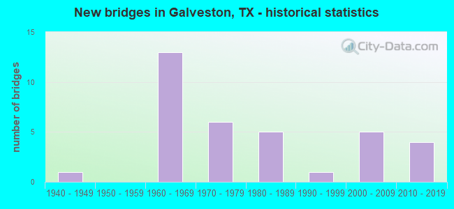
- New bridges - historical statistics
- 11940-1949
- 131960-1969
- 61970-1979
- 51980-1989
- 11990-1999
- 52000-2009
- 42010-2019
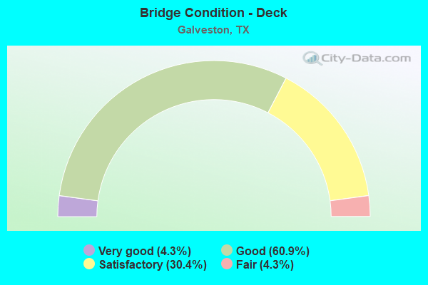
- Bridge Condition - Deck
- 4.3%Very good
- 60.9%Good
- 30.4%Satisfactory
- 4.3%Fair
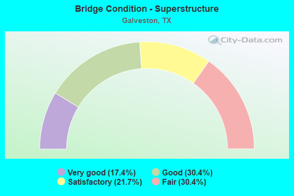
- Bridge Condition - Superstructure
- 17.4%Very good
- 30.4%Good
- 21.7%Satisfactory
- 30.4%Fair
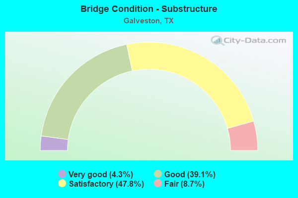
- Bridge Condition - Substructure
- 4.3%Very good
- 39.1%Good
- 47.8%Satisfactory
- 8.7%Fair
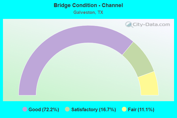
- Bridge Condition - Channel
- 72.2%Good
- 16.7%Satisfactory
- 11.1%Fair
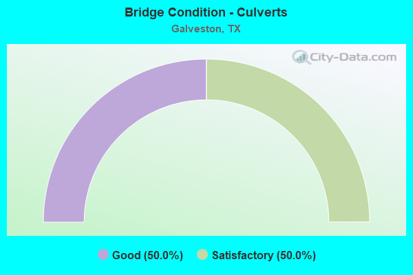
- Bridge Condition - Culverts
- 50.0%Good
- 50.0%Satisfactory
Find on map >> Show street view
Structure Number: 120850005103039, Location: 1.50 MI SE OF FM 518 (Lat: 29.490492, Lng: -95.079286), Route carried "on" structure: State highway 3, Year Built: 1971, Status: Open, Structure Length: 1.86m (6.10ft), Average Daily Traffic: 14,051 (year 2020), Truck Traffic: 6%, Average Future Daily Traffic: 12,630 (year 2033), Design Load: HS 20, Features Intersected: DRAINAGE DITCH
Minimum Vertical Clearance: 30+ m (98+ ft), Kilometerpoint: 5.739, Lanes on structure: 5, Owner: State Highway Agency, Approaching Roadway Width: 19.8m (65.0ft), Skew: 4 degrees, Material/Design: Concrete, Design/Construction: Culvert, Number Of Spans In Main Unit: 5, Length of Maximum Span: 2.4m (7.9ft)
Condition: Channel: Good, Culverts: Good, Operating Rating: 39.9 metric tons, Method Used To Determine Operating Rating: Load Factor (LF), Inventory Rating: 23.6 metric tons, Method Used To Determine Inventory Rating: Load Factor (LF), Structural Evaluation: Somewhat better than minimum adequacy, Waterway Adequacy: Equal to present minimum criteria, Approach Roadway Alignment: Equal to present desirable criteria, Designated Inspection Frequency: Every 24 months, Inspection Date: September 2020
Find on map >> Show street view
Structure Number: 120850005108034, Location: 0.30 MI S OF IH 45 (Lat: 29.284450, Lng: -94.835889), Route carried "on" structure: Spur State highway 342, Year Built: 1967, Status: Open, Structure Length: 3.66m (12.01ft), Average Daily Traffic: 17,150 (year 2020), Truck Traffic: 2%, Average Future Daily Traffic: 15,170 (year 2033), Design Load: HS 20, Features Intersected: OFFATTS BAYOU
Minimum Vertical Clearance: 30+ m (98+ ft), Kilometerpoint: 2.091, Lanes on structure: 3, Owner: State Highway Agency, Approaching Roadway Width: 10.1m (33.1ft), Material/Design: Prestressed concrete, Design/Construction: Box Beam or Girders - Multiple, Number Of Spans In Main Unit: 1, Number Of Approach Spans: 2, Length of Maximum Span: 12.2m (40.0ft), Curb or Sidewalk Widths: Left: 0.0m, Right: 1.2m (3.9ft), Curb-To-Curb Width: 10.1m (33.1ft), Out-to-Out Width: 14.0m (45.9ft)
Condition: Deck: Good, Superstructure: Fair, Substructure: Satisfactory, Channel: Good, Operating Rating: 54.4 metric tons, Method Used To Determine Operating Rating: Load Factor (LF), Inventory Rating: 32.7 metric tons, Method Used To Determine Inventory Rating: Load Factor (LF), Structural Evaluation: Somewhat better than minimum adequacy, Deck Geometry: High priority of replacement, Waterway Adequacy: Equal to present minimum criteria, Approach Roadway Alignment: Equal to present desirable criteria, Length Of Structure Improvement: 3.66m (12.01ft), Designated Inspection Frequency: Every 24 months, Underwater Inspection Frequency: Every 60 months, Inspection Date: September 2020, Underwater Inspection Date: November 2017, Bridge Improvement Cost: $8,000, Roadway Improvement Cost: $2,000, Total Project Cost: $10,000, Deck Structure Type: Concrete Cast-file-Place, Wearing Surface/Protective System: Wearing Surface: Bituminous
Find on map >> Show street view
Structure Number: 12085000510805, Location: 0.30 MI S OF IH 45 (Lat: 29.284544, Lng: -94.835711), Route carried "on" structure: Spur State highway 342, Year Built: 1967, Status: Open, Structure Length: 3.66m (12.01ft), Average Daily Traffic: 14,774 (year 2020), Truck Traffic: 2%, Average Future Daily Traffic: 15,170 (year 2033), Design Load: HS 20, Features Intersected: OFFATTS BAYOU
Minimum Vertical Clearance: 30+ m (98+ ft), Kilometerpoint: 2.091, Lanes on structure: 3, Owner: State Highway Agency, Approaching Roadway Width: 10.1m (33.1ft), Material/Design: Prestressed concrete, Design/Construction: Box Beam or Girders - Multiple, Number Of Spans In Main Unit: 1, Number Of Approach Spans: 2, Length of Maximum Span: 12.2m (40.0ft), Curb or Sidewalk Widths: Left: 1.2m (3.9ft), Right: 0.0m, Curb-To-Curb Width: 10.1m (33.1ft), Out-to-Out Width: 13.4m (44.0ft)
Condition: Deck: Good, Superstructure: Fair, Substructure: Satisfactory, Channel: Good, Operating Rating: 54.4 metric tons, Method Used To Determine Operating Rating: Load Factor (LF), Inventory Rating: 32.7 metric tons, Method Used To Determine Inventory Rating: Load Factor (LF), Structural Evaluation: Somewhat better than minimum adequacy, Deck Geometry: High priority of replacement, Waterway Adequacy: Equal to present minimum criteria, Approach Roadway Alignment: Equal to present desirable criteria, Length Of Structure Improvement: 3.66m (12.01ft), Designated Inspection Frequency: Every 24 months, Underwater Inspection Frequency: Every 60 months, Inspection Date: September 2020, Underwater Inspection Date: November 2017, Bridge Improvement Cost: $8,000, Roadway Improvement Cost: $2,000, Total Project Cost: $10,000, Deck Structure Type: Concrete Cast-file-Place, Wearing Surface/Protective System: Wearing Surface: Bituminous
Find on map >> Show street view
Structure Number: 120850036706026, Location: 1.30 MI N OF SEAWALL BLVD (Lat: 29.327611, Lng: -94.773144), Route carried "on" structure: State highway 87, Year Built: 1980, Status: Open, Structure Length: 4.11m (13.48ft), Average Daily Traffic: 4,230 (year 2020), Average Future Daily Traffic: 2,730 (year 2031), Design Load: HS 20, Features Intersected: GALVESTON BAY
Minimum Vertical Clearance: 4.72m (15.49ft), Kilometerpoint: 1.619, Lanes on structure: 2, Owner: State Highway Agency, Approaching Roadway Width: 7.9m (25.9ft), Material/Design: Steel, Design/Construction: Movable - Lift, Number Of Spans In Main Unit: 1, Number Of Approach Spans: 3, Length of Maximum Span: 13.7m (44.9ft), Curb or Sidewalk Widths: Left: 0.0m, Right: 1.9m (6.2ft), Curb-To-Curb Width: 7.9m (25.9ft), Out-to-Out Width: 10.7m (35.1ft)
Condition: Deck: Good, Superstructure: Fair, Substructure: Satisfactory, Channel: Good, Operating Rating: 40.8 metric tons, Method Used To Determine Operating Rating: Load Factor (LF), Inventory Rating: 24.5 metric tons, Method Used To Determine Inventory Rating: Load Factor (LF), Structural Evaluation: Somewhat better than minimum adequacy, Deck Geometry: High priority of corrective action, Waterway Adequacy: Equal to present minimum criteria, Approach Roadway Alignment: Equal to present desirable criteria, Length Of Structure Improvement: 4.11m (13.48ft), Designated Inspection Frequency: Every 24 months, Underwater Inspection Frequency: Every 60 months, Inspection Date: September 2020, Underwater Inspection Date: Febuary 2018, Bridge Improvement Cost: $7,000, Roadway Improvement Cost: $2,000, Total Project Cost: $9,000, Deck Structure Type: Open Grating
Find on map >> Show street view
Structure Number: 120850036706031, Location: 1.3 MI N OF SEAWALL BLVD (Lat: 29.326708, Lng: -94.773247), Route carried "on" structure: State highway 87, Year Built: 2006, Status: Open, Structure Length: 6.71m (22.01ft), Average Daily Traffic: 4,230 (year 2020), Truck Traffic: 9%, Average Future Daily Traffic: 4,130 (year 2036), Design Load: HS 25 or greater, Features Intersected: GALVESTON BAY
Minimum Vertical Clearance: 5.18m (16.99ft), Kilometerpoint: 1.619, Lanes on structure: 2, Owner: State Highway Agency, Approaching Roadway Width: 7.9m (25.9ft), Skew: 9 degrees, Material/Design: Steel, Design/Construction: Movable - Lift, Number Of Spans In Main Unit: 1, Number Of Approach Spans: 6, Length of Maximum Span: 12.2m (40.0ft), Curb or Sidewalk Widths: Left: 0.0m, Right: 3.4m (11.2ft), Curb-To-Curb Width: 8.0m (26.2ft), Out-to-Out Width: 12.2m (40.0ft)
Condition: Deck: Good, Superstructure: Satisfactory, Substructure: Satisfactory, Channel: Good, Operating Rating: 68.0 metric tons, Method Used To Determine Operating Rating: Assigned rating based on Load Factor Design (LFD) reported in metric tons, Inventory Rating: 40.8 metric tons, Method Used To Determine Inventory Rating: Assigned rating based on Load Factor Design (LFD) reported in metric tons, Structural Evaluation: Equal to present minimum criteria, Deck Geometry: High priority of corrective action, Waterway Adequacy: Equal to present minimum criteria, Approach Roadway Alignment: Equal to present desirable criteria, Length Of Structure Improvement: 7.71m (25.30ft), Designated Inspection Frequency: Every 24 months, Underwater Inspection Frequency: Every 60 months, Inspection Date: September 2020, Underwater Inspection Date: Febuary 2018, Bridge Improvement Cost: $391,000, Roadway Improvement Cost: $98,000, Total Project Cost: $489,000, Deck Structure Type: Open Grating
Find on map >> Show street view
Structure Number: 120850036706033, Location: 1.3 MI N OF SEAWALL BLVD (Lat: 29.327125, Lng: -94.773131), Route carried "on" structure: State highway 87, Year Built: 2006, Status: Open, Structure Length: 5.24m (17.19ft), Average Daily Traffic: 4,230 (year 2020), Truck Traffic: 9%, Average Future Daily Traffic: 4,130 (year 2036), Design Load: HS 25 or greater, Features Intersected: GALVESTON BAY
Minimum Vertical Clearance: 5.18m (16.99ft), Kilometerpoint: 1.619, Lanes on structure: 2, Owner: State Highway Agency, Approaching Roadway Width: 7.9m (25.9ft), Skew: 9 degrees, Material/Design: Steel, Design/Construction: Movable - Lift, Number Of Spans In Main Unit: 1, Number Of Approach Spans: 5, Length of Maximum Span: 12.2m (40.0ft), Curb or Sidewalk Widths: Left: 0.0m, Right: 3.4m (11.2ft), Curb-To-Curb Width: 8.0m (26.2ft), Out-to-Out Width: 12.2m (40.0ft)
Condition: Deck: Good, Superstructure: Fair, Substructure: Satisfactory, Channel: Good, Operating Rating: 68.0 metric tons, Method Used To Determine Operating Rating: Assigned rating based on Load Factor Design (LFD) reported in metric tons, Inventory Rating: 40.8 metric tons, Method Used To Determine Inventory Rating: Assigned rating based on Load Factor Design (LFD) reported in metric tons, Structural Evaluation: Somewhat better than minimum adequacy, Deck Geometry: High priority of corrective action, Waterway Adequacy: Equal to present minimum criteria, Approach Roadway Alignment: Equal to present desirable criteria, Length Of Structure Improvement: 5.24m (17.19ft), Designated Inspection Frequency: Every 24 months, Underwater Inspection Frequency: Every 60 months, Inspection Date: September 2020, Underwater Inspection Date: Febuary 2018, Bridge Improvement Cost: $9,000, Roadway Improvement Cost: $2,000, Total Project Cost: $11,000, Deck Structure Type: Open Grating
Find on map >> Show street view
Structure Number: 120850050001123, Location: 1.55 MI W OF SP 342 (Lat: 29.285456, Lng: -94.862753), Route carried "on" structure: Interstate 45, Year Built: 1965, Status: Open, Structure Length: 6.10m (20.01ft), Average Daily Traffic: 29,774 (year 2018), Truck Traffic: 4%, Average Future Daily Traffic: 37,820 (year 2033), Design Load: HS 20, Features Intersected: FM 188
Minimum Vertical Clearance: 30+ m (98+ ft), Kilometerpoint: 18.979, Lanes on structure: 3, Lanes under structure: 6, Owner: State Highway Agency, Approaching Roadway Width: 14.0m (45.9ft), Material/Design: Prestressed concrete, Design/Construction: Stringer/Multi-beam, Number Of Spans In Main Unit: 4, Length of Maximum Span: 15.2m (49.9ft), Curb-To-Curb Width: 14.6m (47.9ft), Out-to-Out Width: 15.1m (49.5ft)
Condition: Deck: Satisfactory, Superstructure: Fair, Substructure: Satisfactory, Operating Rating: 68.0 metric tons, Method Used To Determine Operating Rating: Load Factor (LF), Inventory Rating: 40.8 metric tons, Method Used To Determine Inventory Rating: Load Factor (LF), Structural Evaluation: Somewhat better than minimum adequacy, Deck Geometry: Meets minimum limits, Underclear: Somewhat better than minimum adequacy, Approach Roadway Alignment: Equal to present desirable criteria, Length Of Structure Improvement: 6.13m (20.11ft), Designated Inspection Frequency: Every 24 months, Inspection Date: August 2020, Deck Structure Type: Concrete Cast-file-Place
Find on map >> Show street view
Structure Number: 120850050001124, Location: 1.55 MI W OF SP 342 (Lat: 29.285194, Lng: -94.863322), Route carried "on" structure: Interstate 45, Year Built: 1965, Status: Open, Structure Length: 6.10m (20.01ft), Average Daily Traffic: 27,010 (year 2013), Truck Traffic: 4%, Average Future Daily Traffic: 37,820 (year 2033), Design Load: HS 20, Features Intersected: FM 188
Minimum Vertical Clearance: 30+ m (98+ ft), Kilometerpoint: 18.979, Lanes on structure: 3, Lanes under structure: 6, Owner: State Highway Agency, Approaching Roadway Width: 14.0m (45.9ft), Material/Design: Prestressed concrete, Design/Construction: Stringer/Multi-beam, Number Of Spans In Main Unit: 4, Length of Maximum Span: 15.2m (49.9ft), Curb-To-Curb Width: 14.6m (47.9ft), Out-to-Out Width: 15.1m (49.5ft)
Condition: Deck: Satisfactory, Superstructure: Satisfactory, Substructure: Satisfactory, Operating Rating: 68.0 metric tons, Method Used To Determine Operating Rating: Load Factor (LF), Inventory Rating: 40.8 metric tons, Method Used To Determine Inventory Rating: Load Factor (LF), Structural Evaluation: Equal to present minimum criteria, Deck Geometry: Meets minimum limits, Underclear: Equal to present minimum criteria, Approach Roadway Alignment: Equal to present desirable criteria, Designated Inspection Frequency: Every 24 months, Inspection Date: August 2020, Deck Structure Type: Concrete Cast-file-Place
Find on map >> Show street view
Structure Number: 120850050001194, Location: 1.50 MI E OF FM 188 (Lat: 29.288428, Lng: -94.838492), Route carried "on" structure: Interstate 45, Year Built: 1976, Status: Open, Structure Length: 10.06m (33.01ft), Average Daily Traffic: 14,490 (year 2013), Truck Traffic: 4%, Average Future Daily Traffic: 20,290 (year 2033), Design Load: HS 20, Features Intersected: SPUR 342
Minimum Vertical Clearance: 30+ m (98+ ft), Kilometerpoint: 16.452, Lanes on structure: 3, Lanes under structure: 8, Owner: State Highway Agency, Approaching Roadway Width: 15.9m (52.2ft), Skew: 2 degrees, Material/Design: Prestressed concrete, Design/Construction: Stringer/Multi-beam, Number Of Spans In Main Unit: 6, Length of Maximum Span: 18.6m (61.0ft), Curb-To-Curb Width: 16.5m (54.1ft), Out-to-Out Width: 17.7m (58.1ft)
Condition: Deck: Good, Superstructure: Good, Substructure: Good, Operating Rating: 54.4 metric tons, Method Used To Determine Operating Rating: Assigned rating based on Load Factor Design (LFD) reported in metric tons, Inventory Rating: 32.7 metric tons, Method Used To Determine Inventory Rating: Assigned rating based on Load Factor Design (LFD) reported in metric tons, Structural Evaluation: Better than present minimum criteria, Deck Geometry: Equal to present minimum criteria, Underclear: Meets minimum limits, Approach Roadway Alignment: Equal to present desirable criteria, Designated Inspection Frequency: Every 24 months, Inspection Date: August 2020, Deck Structure Type: Concrete Cast-file-Place
Find on map >> Show street view
Structure Number: 120850050001204, Location: 0.80 MI NE OF FM 188 (Lat: 29.288614, Lng: -94.850350), Route carried "on" structure: Interstate 45, Year Built: 1965, Status: Open, Structure Length: 6.10m (20.01ft), Average Daily Traffic: 29,774 (year 2018), Truck Traffic: 4%, Average Future Daily Traffic: 37,820 (year 2033), Design Load: HS 20, Features Intersected: 71ST ST
Minimum Vertical Clearance: 30+ m (98+ ft), Kilometerpoint: 17.687, Lanes on structure: 3, Lanes under structure: 6, Owner: State Highway Agency, Approaching Roadway Width: 14.0m (45.9ft), Skew: 1 degrees, Material/Design: Prestressed concrete, Design/Construction: Stringer/Multi-beam, Number Of Spans In Main Unit: 4, Length of Maximum Span: 15.2m (49.9ft), Curb-To-Curb Width: 14.6m (47.9ft), Out-to-Out Width: 15.1m (49.5ft)
Condition: Deck: Satisfactory, Superstructure: Satisfactory, Substructure: Good, Operating Rating: 68.0 metric tons, Method Used To Determine Operating Rating: Load Factor (LF), Inventory Rating: 40.8 metric tons, Method Used To Determine Inventory Rating: Load Factor (LF), Structural Evaluation: Equal to present minimum criteria, Deck Geometry: Meets minimum limits, Underclear: Somewhat better than minimum adequacy, Approach Roadway Alignment: Equal to present desirable criteria, Designated Inspection Frequency: Every 24 months, Inspection Date: August 2020, Deck Structure Type: Concrete Cast-file-Place
Find on map >> Show street view
Structure Number: 120850050001205, Location: 0.80 MI NE OF FM 188 (Lat: 29.288442, Lng: -94.850319), Route carried "on" structure: Interstate 45, Year Built: 1965, Status: Open, Structure Length: 6.10m (20.01ft), Average Daily Traffic: 27,222 (year 2018), Truck Traffic: 4%, Average Future Daily Traffic: 37,820 (year 2033), Design Load: HS 20, Features Intersected: 71ST ST
Minimum Vertical Clearance: 30+ m (98+ ft), Kilometerpoint: 17.692, Lanes on structure: 3, Lanes under structure: 6, Owner: State Highway Agency, Approaching Roadway Width: 14.0m (45.9ft), Skew: 1 degrees, Material/Design: Prestressed concrete, Design/Construction: Stringer/Multi-beam, Number Of Spans In Main Unit: 4, Length of Maximum Span: 15.2m (49.9ft), Curb-To-Curb Width: 14.6m (47.9ft), Out-to-Out Width: 15.1m (49.5ft)
Condition: Deck: Satisfactory, Superstructure: Good, Substructure: Good, Operating Rating: 68.0 metric tons, Method Used To Determine Operating Rating: Load Factor (LF), Inventory Rating: 40.8 metric tons, Method Used To Determine Inventory Rating: Load Factor (LF), Structural Evaluation: Better than present minimum criteria, Deck Geometry: Meets minimum limits, Underclear: Somewhat better than minimum adequacy, Approach Roadway Alignment: Equal to present desirable criteria, Designated Inspection Frequency: Every 24 months, Inspection Date: August 2020, Deck Structure Type: Concrete Cast-file-Place
Find on map >> Show street view
Structure Number: 120850050001206, Location: 1.50 MI E OF FM 188 (Lat: 29.288489, Lng: -94.837900), Route carried "on" structure: Interstate 45, Year Built: 1976, Status: Open, Structure Length: 10.06m (33.01ft), Average Daily Traffic: 14,490 (year 2013), Truck Traffic: 4%, Average Future Daily Traffic: 20,290 (year 2033), Design Load: HS 20, Features Intersected: SPUR 342
Minimum Vertical Clearance: 30+ m (98+ ft), Kilometerpoint: 16.452, Lanes on structure: 3, Lanes under structure: 8, Owner: State Highway Agency, Approaching Roadway Width: 15.9m (52.2ft), Skew: 2 degrees, Material/Design: Prestressed concrete, Design/Construction: Stringer/Multi-beam, Number Of Spans In Main Unit: 6, Length of Maximum Span: 18.6m (61.0ft), Curb-To-Curb Width: 16.5m (54.1ft), Out-to-Out Width: 18.1m (59.4ft)
Condition: Deck: Satisfactory, Superstructure: Satisfactory, Substructure: Good, Operating Rating: 68.0 metric tons, Method Used To Determine Operating Rating: Load Factor (LF), Inventory Rating: 30.8 metric tons, Method Used To Determine Inventory Rating: Load Factor (LF), Structural Evaluation: Equal to present minimum criteria, Deck Geometry: Equal to present minimum criteria, Underclear: Meets minimum limits, Approach Roadway Alignment: Equal to present desirable criteria, Designated Inspection Frequency: Every 24 months, Inspection Date: August 2020, Deck Structure Type: Concrete Cast-file-Place
Find on map >> Show street view
Structure Number: 120850050001373, Location: 3.70 MI SE OF SH 6 (Lat: 29.291261, Lng: -94.876528), Route carried "on" structure: Interstate 45, Year Built: 2006, Status: Open, Structure Length: 261.88m (859.19ft), Average Daily Traffic: 34,360 (year 2010), Truck Traffic: 4%, Average Future Daily Traffic: 48,100 (year 2030), Design Load: HS 25 or greater, Features Intersected: GALVESTON BAY
Minimum Vertical Clearance: 30+ m (98+ ft), Kilometerpoint: 20.556, Lanes on structure: 4, Owner: State Highway Agency, Approaching Roadway Width: 21.9m (71.9ft), Navigation Control: Yes ( Vertical Clearance: 22.3m (73.2ft), Horizontal Clearance: 38.1m (125.0ft)), Material/Design: Prestressed concrete continuous, Design/Construction: Segmental Box Girder, Number Of Spans In Main Unit: 3, Number Of Approach Spans: 59, Length of Maximum Span: 106.7m (350.1ft), Curb-To-Curb Width: 21.8m (71.5ft), Out-to-Out Width: 22.6m (74.1ft)
Condition: Deck: Good, Superstructure: Good, Substructure: Satisfactory, Channel: Good, Operating Rating: 68.0 metric tons, Method Used To Determine Operating Rating: Assigned rating based on Load Factor Design (LFD) reported in metric tons, Inventory Rating: 40.8 metric tons, Method Used To Determine Inventory Rating: Assigned rating based on Load Factor Design (LFD) reported in metric tons, Structural Evaluation: Equal to present minimum criteria, Deck Geometry: Better than present minimum criteria, Waterway Adequacy: Equal to present desirable criteria, Approach Roadway Alignment: Equal to present desirable criteria, Designated Inspection Frequency: Every 24 months, Underwater Inspection Frequency: Every 60 months, Inspection Date: October 2020, Underwater Inspection Date: July 2021, Deck Structure Type: Concrete Cast-file-Place
Find on map >> Show street view
Structure Number: 120850359501001, Location: 2.50 MI E OF IH 45 (Lat: 29.298689, Lng: -94.829306), Route carried "on" structure: State highway 275, Year Built: 1985, Status: Open, Structure Length: 29.84m (97.90ft), Average Daily Traffic: 15,757 (year 2016), Truck Traffic: 7%, Average Future Daily Traffic: 16,920 (year 2033), Design Load: HS 20, Features Intersected: UP RR & OLD PORT INDU RD
Minimum Vertical Clearance: 30+ m (98+ ft), Kilometerpoint: 3.951, Lanes on structure: 4, Lanes under structure: 1, Owner: State Highway Agency, Approaching Roadway Width: 23.2m (76.1ft), Skew: 9 degrees, Material/Design: Prestressed concrete, Design/Construction: Stringer/Multi-beam, Number Of Spans In Main Unit: 9, Length of Maximum Span: 35.4m (116.1ft), Curb-To-Curb Width: 23.0m (75.5ft), Out-to-Out Width: 23.9m (78.4ft)
Condition: Deck: Good, Superstructure: Good, Substructure: Satisfactory, Operating Rating: 54.4 metric tons, Method Used To Determine Operating Rating: Assigned rating based on Load Factor Design (LFD) reported in metric tons, Inventory Rating: 32.7 metric tons, Method Used To Determine Inventory Rating: Assigned rating based on Load Factor Design (LFD) reported in metric tons, Structural Evaluation: Equal to present minimum criteria, Deck Geometry: Superior to present desirable criteria, Underclear: Equal to present minimum criteria, Approach Roadway Alignment: Equal to present desirable criteria, Designated Inspection Frequency: Every 24 months, Critical Feature Inspection Frequency: Every 24 months, Inspection Date: October 2020, Critical Feature Inspection Date: March 2021, Deck Structure Type: Concrete Cast-file-Place
Find on map >> Show street view
Structure Number: 120850359501002, Location: 2.60 MI E OF IH 45 (Lat: 29.299658, Lng: -94.821078), Route carried "on" structure: State highway 275, Year Built: 1985, Status: Open, Structure Length: 55.93m (183.50ft), Average Daily Traffic: 11,822 (year 2020), Truck Traffic: 17%, Average Future Daily Traffic: 16,800 (year 2033), Design Load: HS 20, Features Intersected: UP AND BNSF RR
Minimum Vertical Clearance: 30+ m (98+ ft), Kilometerpoint: 4.260, Lanes on structure: 4, Owner: State Highway Agency, Approaching Roadway Width: 20.7m (67.9ft), Material/Design: Prestressed concrete, Design/Construction: Stringer/Multi-beam, Number Of Spans In Main Unit: 17, Length of Maximum Span: 34.1m (111.9ft), Curb-To-Curb Width: 20.5m (67.3ft), Out-to-Out Width: 21.4m (70.2ft)
Condition: Deck: Good, Superstructure: Good, Substructure: Satisfactory, Operating Rating: 54.4 metric tons, Method Used To Determine Operating Rating: Assigned rating based on Load Factor Design (LFD) reported in metric tons, Inventory Rating: 32.7 metric tons, Method Used To Determine Inventory Rating: Assigned rating based on Load Factor Design (LFD) reported in metric tons, Structural Evaluation: Equal to present minimum criteria, Deck Geometry: Superior to present desirable criteria, Underclear: Equal to present minimum criteria, Approach Roadway Alignment: Equal to present desirable criteria, Designated Inspection Frequency: Every 24 months, Critical Feature Inspection Frequency: Every 24 months, Inspection Date: October 2020, Critical Feature Inspection Date: September 2020, Deck Structure Type: Concrete Cast-file-Place
Find on map >> Show street view
Structure Number: 120850B00039214, Location: 0.3 Mi NW of Stewart Rd (Lat: 29.231572, Lng: -95.911525), Route carried "on" structure: City street , Year Built: 2014, Status: Open, Structure Length: 1.46m (4.79ft), Average Daily Traffic: 199 (year 2018), Truck Traffic: 3%, Average Future Daily Traffic: 279 (year 2038), Features Intersected: MENBELL BAYOU, Facility Carried by Structure: 10 MILE RD
Minimum Vertical Clearance: 30+ m (98+ ft), Kilometerpoint: 0.491, Lanes on structure: 2, Owner: City or Municipal Highway Agency, Approaching Roadway Width: 5.5m (18.0ft), Material/Design: Concrete, Design/Construction: Culvert, Number Of Spans In Main Unit: 6, Length of Maximum Span: 1.8m (5.9ft), Curb-To-Curb Width: 5.8m (19.0ft), Out-to-Out Width: 10.1m (33.1ft)
Condition: Channel: Good, Culverts: Good, Operating Rating: 32.7 metric tons, Method Used To Determine Operating Rating: Field evaluation and documented engineering judgment, Inventory Rating: 24.5 metric tons, Method Used To Determine Inventory Rating: Field evaluation and documented engineering judgment, Structural Evaluation: Equal to present minimum criteria, Deck Geometry: High priority of corrective action, Waterway Adequacy: Better than present minimum criteria, Approach Roadway Alignment: Equal to present desirable criteria, Designated Inspection Frequency: Every 24 months, Inspection Date: December 2021, Deck Structure Type: Concrete Cast-file-Place, Wearing Surface/Protective System: Wearing Surface: Bituminous
Find on map >> Show street view
Structure Number: 120850B00270079, Location: 0.2 MI E OF SEAWALL BLVD (Lat: 29.624861, Lng: -95.001583), Route carried "on" structure: City street , Year Built: 2003, Status: Open, Structure Length: 2.74m (8.99ft), Average Daily Traffic: 820 (year 2011), Average Future Daily Traffic: 900 (year 2031), Design Load: HS 20, Features Intersected: CLOUD BAYOU, Facility Carried by Structure: BODDEKER RD.
Minimum Vertical Clearance: 30+ m (98+ ft), Kilometerpoint: 0.322, Lanes on structure: 2, Owner: City or Municipal Highway Agency, Approaching Roadway Width: 7.3m (24.0ft), Material/Design: Prestressed concrete, Design/Construction: Box Beam or Girders - Multiple, Number Of Spans In Main Unit: 1, Length of Maximum Span: 27.4m (89.9ft), Curb-To-Curb Width: 10.0m (32.8ft), Out-to-Out Width: 10.6m (34.8ft)
Condition: Deck: Good, Superstructure: Very good, Substructure: Good, Channel: Good, Operating Rating: 54.4 metric tons, Method Used To Determine Operating Rating: Assigned rating based on Load Factor Design (LFD) reported in metric tons, Inventory Rating: 32.7 metric tons, Method Used To Determine Inventory Rating: Assigned rating based on Load Factor Design (LFD) reported in metric tons, Structural Evaluation: Better than present minimum criteria, Deck Geometry: Equal to present minimum criteria, Waterway Adequacy: Better than present minimum criteria, Approach Roadway Alignment: Equal to present desirable criteria, Designated Inspection Frequency: Every 24 months, Inspection Date: November 2021, Deck Structure Type: Concrete Cast-file-Place
Find on map >> Show street view
Structure Number: 120850B00270215, Location: 0.2 Mi E of Seawall Blvd (Lat: 29.334311, Lng: -94.749775), Route carried "on" structure: City street , Year Built: 2000, Status: Open, Structure Length: 2.74m (8.99ft), Average Daily Traffic: 1,000 (year 2020), Truck Traffic: 3%, Average Future Daily Traffic: 1,500 (year 2040), Features Intersected: The Lagoon, Facility Carried by Structure: Boddeker Road
Minimum Vertical Clearance: 30+ m (98+ ft), Kilometerpoint: 0.290, Lanes on structure: 2, Owner: City or Municipal Highway Agency, Approaching Roadway Width: 7.3m (24.0ft), Material/Design: Prestressed concrete, Design/Construction: Box Beam or Girders - Multiple, Number Of Spans In Main Unit: 1, Length of Maximum Span: 27.4m (89.9ft), Curb-To-Curb Width: 9.8m (32.2ft), Out-to-Out Width: 10.6m (34.8ft)
Condition: Deck: Very good, Superstructure: Good, Substructure: Very good, Channel: Satisfactory, Operating Rating: 32.7 metric tons, Method Used To Determine Operating Rating: Field evaluation and documented engineering judgment, Inventory Rating: 24.5 metric tons, Method Used To Determine Inventory Rating: Field evaluation and documented engineering judgment, Structural Evaluation: Equal to present minimum criteria, Deck Geometry: Equal to present minimum criteria, Waterway Adequacy: Better than present minimum criteria, Approach Roadway Alignment: Equal to present desirable criteria, Designated Inspection Frequency: Every 24 months, Inspection Date: December 2021, Deck Structure Type: Concrete Cast-file-Place
Find on map >> Show street view
Structure Number: 120850B00304216, Location: 0.3 Mi NW of Stewart Rd (Lat: 29.228083, Lng: -94.917664), Route carried "on" structure: City street , Year Built: 2011, Status: Open, Structure Length: 1.77m (5.81ft), Average Daily Traffic: 198 (year 2018), Truck Traffic: 3%, Average Future Daily Traffic: 297 (year 2038), Features Intersected: Menbell Bayou, Facility Carried by Structure: Camino Real
Minimum Vertical Clearance: 30+ m (98+ ft), Kilometerpoint: 0.443, Lanes on structure: 2, Owner: City or Municipal Highway Agency, Approaching Roadway Width: 4.9m (16.1ft), Material/Design: Prestressed concrete, Design/Construction: Slab, Number Of Spans In Main Unit: 2, Length of Maximum Span: 8.8m (28.9ft), Curb-To-Curb Width: 9.5m (31.2ft), Out-to-Out Width: 10.2m (33.5ft)
Condition: Deck: Good, Superstructure: Very good, Substructure: Good, Channel: Good, Operating Rating: 32.7 metric tons, Method Used To Determine Operating Rating: Field evaluation and documented engineering judgment, Inventory Rating: 24.5 metric tons, Method Used To Determine Inventory Rating: Field evaluation and documented engineering judgment, Structural Evaluation: Equal to present minimum criteria, Deck Geometry: Equal to present minimum criteria, Waterway Adequacy: Superior to present desirable criteria, Approach Roadway Alignment: Equal to present desirable criteria, Designated Inspection Frequency: Every 24 months, Inspection Date: December 2021, Deck Structure Type: Concrete Cast-file-Place
Find on map >> Show street view
Structure Number: 120850B00531217, Location: 0.4 Mi NW of FM 3005 (Lat: 29.137872, Lng: -95.055169), Route carried "on" structure: City street , Year Built: 1985, Status: Open, Structure Length: 1.22m (4.00ft), Average Daily Traffic: 91 (year 2018), Truck Traffic: 3%, Average Future Daily Traffic: 136 (year 2038), Features Intersected: Isla Del Sol Bayou, Facility Carried by Structure: Isla Del Sol Drive
Minimum Vertical Clearance: 30+ m (98+ ft), Kilometerpoint: 0.604, Lanes on structure: 2, Owner: City or Municipal Highway Agency, Approaching Roadway Width: 7.3m (24.0ft), Material/Design: Concrete, Design/Construction: Culvert, Number Of Spans In Main Unit: 5, Length of Maximum Span: 1.8m (5.9ft), Curb-To-Curb Width: 7.3m (24.0ft), Out-to-Out Width: 14.5m (47.6ft)
Condition: Channel: Good, Culverts: Satisfactory, Operating Rating: 32.7 metric tons, Method Used To Determine Operating Rating: Field evaluation and documented engineering judgment, Inventory Rating: 24.5 metric tons, Method Used To Determine Inventory Rating: Field evaluation and documented engineering judgment, Structural Evaluation: Equal to present minimum criteria, Deck Geometry: Equal to present minimum criteria, Waterway Adequacy: Better than present minimum criteria, Approach Roadway Alignment: Equal to present desirable criteria, Designated Inspection Frequency: Every 24 months, Inspection Date: December 2021, Deck Structure Type: Concrete Cast-file-Place, Wearing Surface/Protective System: Wearing Surface: Monolithic Concrete
Find on map >> Show street view
Structure Number: 120850B00535001, Location: 1.0 MI W OF SPUR 342 (Lat: 29.269169, Lng: -94.846478), Route carried "on" structure: City street , Year Built: 1997, Status: Posted for load, Structure Length: 3.08m (10.10ft), Average Daily Traffic: 2,980 (year 2010), Average Future Daily Traffic: 3,000 (year 2028), Design Load: HS 20, Features Intersected: LAKE MADELINE, Facility Carried by Structure: JONES DR EB
Minimum Vertical Clearance: 30+ m (98+ ft), Kilometerpoint: 1.609, Lanes on structure: 2, Owner: City or Municipal Highway Agency, Approaching Roadway Width: 7.3m (24.0ft), Navigation Control: Yes ( Vertical Clearance: 4.3m (14.1ft), Horizontal Clearance: 10.1m (33.1ft)), Material/Design: Prestressed concrete, Design/Construction: Stringer/Multi-beam, Number Of Spans In Main Unit: 1, Number Of Approach Spans: 2, Length of Maximum Span: 12.2m (40.0ft), Curb or Sidewalk Widths: Left: 0.0m, Right: 2.2m (7.2ft), Curb-To-Curb Width: 7.4m (24.3ft), Out-to-Out Width: 10.3m (33.8ft)
Condition: Deck: Good, Superstructure: Very good, Substructure: Good, Channel: Satisfactory, Operating Rating: 54.4 metric tons, Method Used To Determine Operating Rating: Assigned rating based on Load Factor Design (LFD) reported in metric tons, Inventory Rating: 32.7 metric tons, Method Used To Determine Inventory Rating: Assigned rating based on Load Factor Design (LFD) reported in metric tons, Structural Evaluation: Better than present minimum criteria, Deck Geometry: High priority of replacement, Waterway Adequacy: Equal to present minimum criteria, Approach Roadway Alignment: Equal to present desirable criteria, Length Of Structure Improvement: 3.05m (10.01ft), Designated Inspection Frequency: Every 24 months, Inspection Date: December 2021, Bridge Improvement Cost: $5,000, Roadway Improvement Cost: $1,000, Total Project Cost: $6,000, Deck Structure Type: Concrete Cast-file-Place
Find on map >> Show street view
Structure Number: 120850B00535002, Location: 1.0 MI W OF SPUR 342 (Lat: 29.269097, Lng: -94.846419), Route carried "on" structure: City street , Year Built: 1970, Status: Posted for load, Structure Length: 3.14m (10.30ft), Average Daily Traffic: 2,980 (year 2010), Average Future Daily Traffic: 3,000 (year 2028), Features Intersected: LAKE MADELINE, Facility Carried by Structure: JONES DR WB
Minimum Vertical Clearance: 30+ m (98+ ft), Kilometerpoint: 1.609, Lanes on structure: 2, Owner: City or Municipal Highway Agency, Approaching Roadway Width: 7.3m (24.0ft), Navigation Control: Yes ( Vertical Clearance: 4.3m (14.1ft), Horizontal Clearance: 10.1m (33.1ft)), Material/Design: Prestressed concrete, Design/Construction: Stringer/Multi-beam, Number Of Spans In Main Unit: 1, Number Of Approach Spans: 2, Length of Maximum Span: 12.2m (40.0ft), Curb-To-Curb Width: 7.3m (24.0ft), Out-to-Out Width: 8.2m (26.9ft)
Condition: Deck: Good, Superstructure: Good, Substructure: Good, Channel: Fair, Operating Rating: 32.7 metric tons, Method Used To Determine Operating Rating: Field evaluation and documented engineering judgment, Inventory Rating: 24.5 metric tons, Method Used To Determine Inventory Rating: Field evaluation and documented engineering judgment, Structural Evaluation: Equal to present minimum criteria, Deck Geometry: High priority of replacement, Waterway Adequacy: Equal to present minimum criteria, Approach Roadway Alignment: Equal to present desirable criteria, Bridge Posting: Required (Relationship of Operating Rating to Maximum Legal Load: 0.1 - 9.9% below), Length Of Structure Improvement: 3.05m (10.01ft), Designated Inspection Frequency: Every 24 months, Inspection Date: December 2021, Bridge Improvement Cost: $5,000, Roadway Improvement Cost: $1,000, Total Project Cost: $6,000, Deck Structure Type: Concrete Cast-file-Place
Find on map >> Show street view
Structure Number: 120850B00720001, Location: AT PORT INDUSTRIAL BLVD (Lat: 29.295869, Lng: -94.825417), Route carried "on" structure: City street , Year Built: 1960, Status: Open, Structure Length: 46.39m (152.20ft), Average Daily Traffic: 16,620 (year 2015), Average Future Daily Traffic: 18,220 (year 2035), Features Intersected: UPRR and City Streets, Facility Carried by Structure: SEAWOLF PKWY
Minimum Vertical Clearance: 30+ m (98+ ft), Kilometerpoint: 0.002, Lanes on structure: 2, Lanes under structure: 4, Owner: City or Municipal Highway Agency, Approaching Roadway Width: 7.9m (25.9ft), Material/Design: Prestressed concrete, Design/Construction: Stringer/Multi-beam, Number Of Spans In Main Unit: 1, Number Of Approach Spans: 28, Length of Maximum Span: 30.5m (100.1ft), Curb or Sidewalk Widths: Left: 0.5m (1.6ft), Right: 0.9m (3.0ft), Curb-To-Curb Width: 7.9m (25.9ft), Out-to-Out Width: 9.8m (32.2ft)
Condition: Deck: Satisfactory, Superstructure: Satisfactory, Substructure: Satisfactory, Operating Rating: 32.7 metric tons, Method Used To Determine Operating Rating: Field evaluation and documented engineering judgment, Inventory Rating: 24.5 metric tons, Method Used To Determine Inventory Rating: Field evaluation and documented engineering judgment, Structural Evaluation: Equal to present minimum criteria, Deck Geometry: High priority of corrective action, Underclear: High priority of corrective action, Approach Roadway Alignment: Equal to present desirable criteria, Bridge Posting: Required (Relationship of Operating Rating to Maximum Legal Load: 0.1 - 9.9% below), Length Of Structure Improvement: 46.39m (152.20ft), Designated Inspection Frequency: Every 24 months, Inspection Date: December 2021, Bridge Improvement Cost: $79,000, Roadway Improvement Cost: $20,000, Total Project Cost: $99,000, Deck Structure Type: Concrete Cast-file-Place
Find on map >> Show street view
Structure Number: 120850B00790001, Location: 1.20 MI N OF BROADWAY AVE (Lat: 29.306886, Lng: -94.825708), Route carried "on" structure: City street , Year Built: 1960, Status: Posted for load, Structure Length: 98.72m (323.88ft), Average Daily Traffic: 9,100 (year 2011), Average Future Daily Traffic: 10,100 (year 2031), Design Load: HS 20, Features Intersected: PELICAN ISLAND CHAN, Facility Carried by Structure: SEAWOLF PKWY
Minimum Vertical Clearance: 30+ m (98+ ft), Kilometerpoint: 0.177, Lanes on structure: 2, Owner: Local Agency, Approaching Roadway Width: 7.9m (25.9ft), Navigation Control: Yes ( Vertical Clearance: 5.5m (18.0ft), Horizontal Clearance: 38.1m (125.0ft)), Material/Design: Steel, Design/Construction: Movable - Bascule, Number Of Spans In Main Unit: 1, Number Of Approach Spans: 51, Length of Maximum Span: 50.0m (164.0ft), Curb or Sidewalk Widths: Left: 0.5m (1.6ft), Right: 0.9m (3.0ft), Curb-To-Curb Width: 7.9m (25.9ft), Out-to-Out Width: 9.3m (30.5ft)
Condition: Deck: Satisfactory, Superstructure: Fair, Substructure: Fair, Channel: Fair, Operating Rating: 49.0 metric tons, Method Used To Determine Operating Rating: Load Factor (LF), Inventory Rating: 33.6 metric tons, Method Used To Determine Inventory Rating: Load Factor (LF), Structural Evaluation: Somewhat better than minimum adequacy, Deck Geometry: High priority of corrective action, Waterway Adequacy: Equal to present desirable criteria, Approach Roadway Alignment: Equal to present desirable criteria, Length Of Structure Improvement: 98.79m (324.11ft), Designated Inspection Frequency: Every 24 months, Critical Feature Inspection Frequency: Every 24 months, Underwater Inspection Frequency: Every 24 months, Inspection Date: December 2021, Critical Feature Inspection Date: March 2020, Underwater Inspection Date: March 2021, Bridge Improvement Cost: $4,992,000, Roadway Improvement Cost: $1,248,000, Total Project Cost: $6,240,000, Deck Structure Type: Open Grating, Wearing Surface/Protective System: Wearing Surface: Other
Find on map >> Show street view
Structure Number: 120850B00816218, Location: 1.05 Mi W of 8 Mile Rd (Lat: 29.258047, Lng: -94.914542), Route carried "on" structure: City street , Year Built: 2012, Status: Open, Structure Length: 0.70m (2.30ft), Average Daily Traffic: 20 (year 2020), Truck Traffic: 1%, Average Future Daily Traffic: 25 (year 2040), Design Load: HL 93, Features Intersected: Gangs Bayou, Facility Carried by Structure: Sportsman Road
Minimum Vertical Clearance: 30+ m (98+ ft), Kilometerpoint: 1.690, Lanes on structure: 2, Owner: City or Municipal Highway Agency, Approaching Roadway Width: 4.9m (16.1ft), Material/Design: Concrete, Design/Construction: Culvert, Number Of Spans In Main Unit: 3, Length of Maximum Span: 1.8m (5.9ft), Curb-To-Curb Width: 6.4m (21.0ft), Out-to-Out Width: 7.4m (24.3ft)
Condition: Channel: Good, Culverts: Satisfactory, Operating Rating: 54.4 metric tons, Method Used To Determine Operating Rating: Assigned ratings based on Load and Resistance Factor Design (LRFD) reported in metric tons, Inventory Rating: 32.7 metric tons, Method Used To Determine Inventory Rating: Assigned ratings based on Load and Resistance Factor Design (LRFD) reported in metric tons, Structural Evaluation: Equal to present minimum criteria, Deck Geometry: Somewhat better than minimum adequacy, Waterway Adequacy: Better than present minimum criteria, Approach Roadway Alignment: Equal to present desirable criteria, Designated Inspection Frequency: Every 24 months, Inspection Date: December 2021, Deck Structure Type: Concrete Precast Panels, Wearing Surface/Protective System: Wearing Surface: Monolithic Concrete
Find on map >> Show street view
Structure Number: 120850B00825001, Location: 0.30 MI E OF PABST RD (Lat: 29.224686, Lng: -94.914536), Route carried "on" structure: City street , Year Built: 1940, Year Reconstructed: 1960, Status: Open, Structure Length: 1.71m (5.61ft), Average Daily Traffic: 1,400 (year 2011), Average Future Daily Traffic: 2,100 (year 2031), Features Intersected: MENBELL BYU, Facility Carried by Structure: STEWART RD
Minimum Vertical Clearance: 30+ m (98+ ft), Kilometerpoint: 5.150, Lanes on structure: 2, Owner: City or Municipal Highway Agency, Approaching Roadway Width: 6.7m (22.0ft), Material/Design: Concrete continuous, Design/Construction: Slab, Number Of Spans In Main Unit: 4, Length of Maximum Span: 4.3m (14.1ft), Curb-To-Curb Width: 12.3m (40.4ft), Out-to-Out Width: 13.1m (43.0ft)
Condition: Deck: Fair, Superstructure: Fair, Substructure: Fair, Channel: Satisfactory, Operating Rating: 32.7 metric tons, Method Used To Determine Operating Rating: Field evaluation and documented engineering judgment, Inventory Rating: 24.5 metric tons, Method Used To Determine Inventory Rating: Field evaluation and documented engineering judgment, Structural Evaluation: Somewhat better than minimum adequacy, Deck Geometry: Better than present minimum criteria, Waterway Adequacy: Meets minimum limits, Approach Roadway Alignment: Equal to present desirable criteria, Length Of Structure Improvement: 1.71m (5.61ft), Designated Inspection Frequency: Every 24 months, Inspection Date: December 2021, Deck Structure Type: Concrete Cast-file-Place, Wearing Surface/Protective System: Wearing Surface: Bituminous
Find on map >> Show street view
Structure Number: 120850B0089012, Location: 1.0 MI W OF STEWART RD (Lat: 29.266989, Lng: -94.873658), Route carried "on" structure: City street , Year Built: 2019, Status: Open, Structure Length: 1.92m (6.30ft), Average Daily Traffic: 450 (year 2018), Average Future Daily Traffic: 550 (year 2038), Features Intersected: SYDNOR BAYOU, Facility Carried by Structure: TRAVEL AIR RD
Minimum Vertical Clearance: 30+ m (98+ ft), Kilometerpoint: 0.161, Lanes on structure: 2, Owner: Town or Township Highway Agency, Approaching Roadway Width: 6.1m (20.0ft), Material/Design: Prestressed concrete, Design/Construction: Slab, Number Of Spans In Main Unit: 2, Length of Maximum Span: 11.3m (37.1ft), Curb or Sidewalk Widths: Left: 0.0m, Right: 3.1m (10.2ft), Curb-To-Curb Width: 7.3m (24.0ft), Out-to-Out Width: 11.5m (37.7ft)
Condition: Deck: Good, Superstructure: Very good, Substructure: Good, Channel: Good, Operating Rating: 32.7 metric tons, Method Used To Determine Operating Rating: Field evaluation and documented engineering judgment, Inventory Rating: 24.5 metric tons, Method Used To Determine Inventory Rating: Field evaluation and documented engineering judgment, Structural Evaluation: Equal to present minimum criteria, Deck Geometry: Meets minimum limits, Waterway Adequacy: Equal to present minimum criteria, Approach Roadway Alignment: Equal to present desirable criteria, Designated Inspection Frequency: Every 24 months, Inspection Date: December 2021, Deck Structure Type: Concrete Cast-file-Place
Find on map >> Show street view
Structure Number: 120850050001123, Location: 1.55 MI W OF SP 342 (Lat: 29.285456, Lng: -94.862753), Route carried "under" structure: State highway 188, Year Built: 1965, Structure Length: 0. m, Average Daily Traffic: 2,100 (year 2013), Truck Traffic: 11%, Features Intersected: FM 188, Facility Carried by Structure: IH 45 NB
Minimum Vertical Clearance: 4.60m (15.09ft), Kilometerpoint: 0.185, Lanes on structure: 3, Lanes under structure: 6, Material/Design: Prestressed concrete, Design/Construction: Stringer/Multi-beam, Length of Maximum Span: 15.2m (49.9ft)
Find on map >> Show street view
Structure Number: 120850050001124, Location: 1.55 MI W OF SP 342 (Lat: 29.285194, Lng: -94.863322), Route carried "under" structure: State highway 188, Year Built: 1965, Structure Length: 0. m, Average Daily Traffic: 2,100 (year 2013), Truck Traffic: 11%, Features Intersected: FM 188, Facility Carried by Structure: IH 45 SB
Minimum Vertical Clearance: 5.26m (17.26ft), Kilometerpoint: 0.217, Lanes on structure: 3, Lanes under structure: 6, Material/Design: Prestressed concrete, Design/Construction: Stringer/Multi-beam, Length of Maximum Span: 15.2m (49.9ft)
Find on map >> Show street view
Structure Number: 120850050001194, Location: 1.50 MI E OF FM 188 (Lat: 29.288317, Lng: -94.837814), Route carried "under" structure: Business State highway 342, Year Built: 1976, Structure Length: 0. m, Average Daily Traffic: 21,670 (year 2013), Truck Traffic: 2%, Features Intersected: SPUR 342, Facility Carried by Structure: IH 45 SB
Minimum Vertical Clearance: 4.93m (16.17ft), Kilometerpoint: 1.625, Lanes on structure: 3, Lanes under structure: 8, Material/Design: Prestressed concrete, Design/Construction: Stringer/Multi-beam, Length of Maximum Span: 18.6m (61.0ft)
Find on map >> Show street view
Structure Number: 120850050001204, Location: 0.80 MI NE OF FM 188 (Lat: 29.288614, Lng: -94.850350), Route carried "under" structure: City street 71, Year Built: 1965, Structure Length: 0. m, Average Daily Traffic: 1,000 (year 2013), Truck Traffic: 12%, Features Intersected: 71ST ST, Facility Carried by Structure: IH 45 NB
Minimum Vertical Clearance: 5.03m (16.50ft), Kilometerpoint: 17.687, Lanes on structure: 3, Lanes under structure: 6, Material/Design: Prestressed concrete, Design/Construction: Stringer/Multi-beam, Length of Maximum Span: 15.2m (49.9ft)
Find on map >> Show street view
Structure Number: 120850050001205, Location: 0.80 MI NE OF FM 188 (Lat: 29.288442, Lng: -94.850319), Route carried "under" structure: City street 71, Year Built: 1965, Structure Length: 0. m, Average Daily Traffic: 1,000 (year 2013), Truck Traffic: 12%, Features Intersected: 71ST ST, Facility Carried by Structure: IH 45 SB
Minimum Vertical Clearance: 4.65m (15.26ft), Kilometerpoint: 17.692, Lanes on structure: 3, Lanes under structure: 6, Material/Design: Prestressed concrete, Design/Construction: Stringer/Multi-beam, Length of Maximum Span: 15.2m (49.9ft)
Find on map >> Show street view
Structure Number: 120850050001206, Location: 1.50 MI E OF FM 188 (Lat: 29.288489, Lng: -94.837900), Route carried "under" structure: Business State highway 342, Year Built: 1976, Structure Length: 0. m, Average Daily Traffic: 21,670 (year 2013), Truck Traffic: 2%, Features Intersected: SPUR 342, Facility Carried by Structure: IH 45 NB
Minimum Vertical Clearance: 4.93m (16.17ft), Kilometerpoint: 1.658, Lanes on structure: 3, Lanes under structure: 8, Material/Design: Prestressed concrete, Design/Construction: Stringer/Multi-beam, Length of Maximum Span: 18.6m (61.0ft)
Find on map >> Show street view
Structure Number: 120850359501001, Location: 2.50 MI E OF IH 45 (Lat: 29.298689, Lng: -94.829306), Route carried "under" structure: US 275, Year Built: 1985, Structure Length: 0. m, Average Daily Traffic: 400 (year 2020), Truck Traffic: 30%, Features Intersected: UPRR & Old Port Indu Rd
Minimum Vertical Clearance: 5.49m (18.01ft), Kilometerpoint: 3.951, Lanes on structure: 4, Lanes under structure: 1, Material/Design: Prestressed concrete, Design/Construction: Stringer/Multi-beam, Length of Maximum Span: 35.4m (116.1ft)
Find on map >> Show street view
Structure Number: 120850B00720001, Location: AT PORT INDUSTRIAL BLVD (Lat: 29.295869, Lng: -94.825417), Route carried "under" structure: County highway , Year Built: 1960, Structure Length: 0. m, Average Daily Traffic: 100 (year 2012), Truck Traffic: 5%, Features Intersected: UPRR and City Streets, Facility Carried by Structure: SEAWOLF PKWY
Minimum Vertical Clearance: 4.32m (14.17ft), Kilometerpoint: 0.000, Lanes on structure: 2, Lanes under structure: 4, Material/Design: Prestressed concrete, Design/Construction: Stringer/Multi-beam, Length of Maximum Span: 30.5m (100.1ft)