Bridge Statistics for Galena, Illinois (IL)
Condition, Traffic, Stress, Structural Evaluation, Project Costs
- National Bridge Inventory (NBI) Statistics
- 12Number of bridges
- 253ft / 77.0mTotal length
- $284,000Total costs
- 15,710Total average daily traffic
- 1,759Total average daily truck traffic
- 18,460Total future (year 2040) average daily traffic
- National Bridge Inventory (NBI) Registered Bridges for Galena
- No street view available for this location
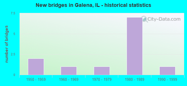
- New bridges - historical statistics
- 21950-1959
- 11960-1969
- 11970-1979
- 71980-1989
- 11990-1999


- Bridge Condition - Deck
- 18.2%Very good
- 54.5%Good
- 18.2%Satisfactory
- 9.1%Poor

- Bridge Condition - Superstructure
- 27.3%Very good
- 36.4%Good
- 9.1%Satisfactory
- 18.2%Fair
- 9.1%Poor

- Bridge Condition - Substructure
- 36.4%Very good
- 27.3%Good
- 27.3%Satisfactory
- 9.1%Fair

- Bridge Condition - Channel
- 8.3%Excellent
- 16.7%Very good
- 25.0%Good
- 33.3%Satisfactory
- 8.3%Fair
- 8.3%Poor
Find on map >> Show street view
Structure Number: 430043, Location: IN GALENA (Lat: 42.410606, Lng: -90.431108), Route carried "on" structure: US 20, Year Built: 1984, Status: Open, Structure Length: 19.26m (63.19ft), Average Daily Traffic: 8,250 (year 2021), Truck Traffic: 12%, Average Future Daily Traffic: 9,500 (year 2040), Design Load: HS 20, Features Intersected: GALENA RIV AND ICGRR
Minimum Vertical Clearance: 30+ m (98+ ft), Kilometerpoint: 23.464, Lanes on structure: 2, Base Highway Network: Yes, Owner: State Highway Agency, Approaching Roadway Width: 8.0m (26.2ft), Skew: 1 degrees, Material/Design: Prestressed concrete continuous, Design/Construction: Stringer/Multi-beam, Number Of Spans In Main Unit: 7, Number Of Approach Spans: 2, Length of Maximum Span: 34.4m (112.9ft), Curb or Sidewalk Widths: Left: 1.7m (5.6ft), Right: 0.0m, Curb-To-Curb Width: 9.8m (32.2ft), Out-to-Out Width: 12.5m (41.0ft)
Condition: Deck: Satisfactory, Superstructure: Fair, Substructure: Good, Channel: Very good, Operating Rating: 60.9 metric tons, Method Used To Determine Operating Rating: Load Factor (LF) rating reported by rating factor (RF) method using MS18 loading, Inventory Rating: 36.6 metric tons, Method Used To Determine Inventory Rating: Load Factor (LF) rating reported by rating factor (RF) method using MS18 loading, Structural Evaluation: Somewhat better than minimum adequacy, Deck Geometry: Meets minimum limits, Underclear: Somewhat better than minimum adequacy, Waterway Adequacy: Equal to present desirable criteria, Approach Roadway Alignment: Equal to present minimum criteria, Designated Inspection Frequency: Every 24 months, Inspection Date: October 2020, Deck Structure Type: Concrete Cast-file-Place, Wearing Surface/Protective System: Deck Protection: Epoxy Coated Reinforcing
Find on map >> Show street view
Structure Number: 433007, Location: 3 MILES SOUTH GALENA (Lat: 42.362075, Lng: -90.400983), Route carried "on" structure: County highway , Year Built: 1959, Status: Open, Structure Length: 3.99m (13.09ft), Average Daily Traffic: 475 (year 2021), Truck Traffic: 5%, Average Future Daily Traffic: 850 (year 2040), Design Load: HS 15, Features Intersected: SMALLPOX CREEK, Facility Carried by Structure: SOUTH BLACKJACK RO
Minimum Vertical Clearance: 30+ m (98+ ft), Kilometerpoint: 6.534, Lanes on structure: 2, Owner: County Highway Agency, Approaching Roadway Width: 7.3m (24.0ft), Material/Design: Concrete continuous, Design/Construction: Tee Beam, Number Of Spans In Main Unit: 3, Length of Maximum Span: 15.2m (49.9ft), Curb-To-Curb Width: 7.3m (24.0ft), Out-to-Out Width: 8.6m (28.2ft)
Condition: Deck: Good, Superstructure: Fair, Substructure: Satisfactory, Channel: Satisfactory, Operating Rating: 50.9 metric tons, Method Used To Determine Operating Rating: Load Factor (LF) rating reported by rating factor (RF) method using MS18 loading, Inventory Rating: 30.5 metric tons, Method Used To Determine Inventory Rating: Load Factor (LF) rating reported by rating factor (RF) method using MS18 loading, Structural Evaluation: Somewhat better than minimum adequacy, Deck Geometry: Meets minimum limits, Waterway Adequacy: Equal to present desirable criteria, Approach Roadway Alignment: Equal to present minimum criteria, Designated Inspection Frequency: Every 24 months, Inspection Date: October 2020, Deck Structure Type: Concrete Cast-file-Place, Wearing Surface/Protective System: Wearing Surface: Bituminous
Find on map >> Show street view
Structure Number: 433024, Location: 3 MI N OF GALENA (Lat: 42.476744, Lng: -90.406906), Route carried "on" structure: County highway , Year Built: 1970, Year Reconstructed: 2018, Status: Open, Structure Length: 6.01m (19.72ft), Average Daily Traffic: 525 (year 2021), Truck Traffic: 22%, Average Future Daily Traffic: 700 (year 2044), Design Load: HS 25 or greater, Features Intersected: GALENA RIVER, Facility Carried by Structure: W COUNCIL HILL ROA
Minimum Vertical Clearance: 30+ m (98+ ft), Kilometerpoint: 4.522, Lanes on structure: 2, Owner: County Highway Agency, Approaching Roadway Width: 6.7m (22.0ft), Material/Design: Prestressed concrete, Design/Construction: Box Beam or Girders - Multiple, Number Of Spans In Main Unit: 3, Length of Maximum Span: 25.3m (83.0ft), Curb-To-Curb Width: 6.7m (22.0ft), Out-to-Out Width: 7.3m (24.0ft)
Condition: Deck: Very good, Superstructure: Very good, Substructure: Very good, Channel: Excellent, Operating Rating: 45.0 metric tons, Method Used To Determine Operating Rating: Load and Resistance Factor Rating (LRFR) rating reported by rating factor(RF) method using HL-93 loadings, Inventory Rating: 35.3 metric tons, Method Used To Determine Inventory Rating: Load and Resistance Factor Rating (LRFR) rating reported by rating factor(RF) method using HL-93 loadings, Structural Evaluation: Equal to present desirable criteria, Deck Geometry: Meets minimum limits, Waterway Adequacy: Superior to present desirable criteria, Approach Roadway Alignment: Equal to present desirable criteria, Designated Inspection Frequency: Every 48 months, Inspection Date: October 2020, Deck Structure Type: Concrete Precast Panels, Wearing Surface/Protective System: Wearing Surface: Bituminous, Membrane: Built-up
Find on map >> Show street view
Structure Number: 43305, Location: 3 MI S.E. OF GALENA (Lat: 42.370789, Lng: -90.393194), Route carried "on" structure: County highway , Year Built: 1963, Status: Open, Structure Length: 1.83m (6.00ft), Average Daily Traffic: 250 (year 2021), Truck Traffic: 17%, Average Future Daily Traffic: 500 (year 2040), Design Load: HS 15, Features Intersected: SMALLPOX CREEK, Facility Carried by Structure: TOWNSHIP ROAD NO 3
Minimum Vertical Clearance: 30+ m (98+ ft), Kilometerpoint: 3.219, Lanes on structure: 2, Owner: Town or Township Highway Agency, Approaching Roadway Width: 6.7m (22.0ft), Material/Design: Steel, Design/Construction: Stringer/Multi-beam, Number Of Spans In Main Unit: 1, Length of Maximum Span: 18.0m (59.1ft), Curb-To-Curb Width: 6.1m (20.0ft), Out-to-Out Width: 6.8m (22.3ft)
Condition: Deck: Satisfactory, Superstructure: Satisfactory, Substructure: Satisfactory, Channel: Satisfactory, Operating Rating: 51.8 metric tons, Method Used To Determine Operating Rating: Load Factor (LF) rating reported by rating factor (RF) method using MS18 loading, Inventory Rating: 31.1 metric tons, Method Used To Determine Inventory Rating: Load Factor (LF) rating reported by rating factor (RF) method using MS18 loading, Structural Evaluation: Equal to present minimum criteria, Deck Geometry: Meets minimum limits, Waterway Adequacy: Equal to present desirable criteria, Approach Roadway Alignment: Somewhat better than minimum adequacy, Designated Inspection Frequency: Every 24 months, Inspection Date: October 2020, Deck Structure Type: Concrete Cast-file-Place, Wearing Surface/Protective System: Deck Protection: Internally Sealed
Find on map >> Show street view
Structure Number: 433184, Location: .3 MI. E. OF GALENA (Lat: 42.421908, Lng: -90.403569), Route carried "on" structure: County highway , Year Built: 1999, Status: Open, Structure Length: 23.83m (78.18ft), Average Daily Traffic: 2,150 (year 2021), Truck Traffic: 8%, Average Future Daily Traffic: 2,500 (year 2040), Design Load: HS 20, Features Intersected: GALENA RIVER &CCP RR, Facility Carried by Structure: W. STAGECOACH TRAI
Minimum Vertical Clearance: 30+ m (98+ ft), Kilometerpoint: 2.977, Lanes on structure: 2, Owner: County Highway Agency, Approaching Roadway Width: 9.8m (32.2ft), Material/Design: Steel continuous, Design/Construction: Stringer/Multi-beam, Number Of Spans In Main Unit: 7, Length of Maximum Span: 36.6m (120.1ft), Curb-To-Curb Width: 9.1m (29.9ft), Out-to-Out Width: 10.1m (33.1ft)
Condition: Deck: Very good, Superstructure: Very good, Substructure: Very good, Channel: Very good, Operating Rating: 44.1 metric tons, Method Used To Determine Operating Rating: Assigned rating based on Load Factor Design (LFD) reported by rating factor (RF) using MS18 loading, Inventory Rating: 32.4 metric tons, Method Used To Determine Inventory Rating: Assigned rating based on Load Factor Design (LFD) reported by rating factor (RF) using MS18 loading, Structural Evaluation: Equal to present desirable criteria, Deck Geometry: Meets minimum limits, Waterway Adequacy: Equal to present desirable criteria, Approach Roadway Alignment: Equal to present desirable criteria, Designated Inspection Frequency: Every 24 months, Inspection Date: March 2020, Deck Structure Type: Concrete Cast-file-Place, Wearing Surface/Protective System: Membrane: Built-up
Find on map >> Show street view
Structure Number: 433211, Location: 2 MI W OF GALENA (Lat: 42.432861, Lng: -90.488603), Route carried "on" structure: County highway , Year Built: 1981, Status: Open, Structure Length: 5.00m (16.40ft), Average Daily Traffic: 250 (year 2021), Truck Traffic: 22%, Average Future Daily Traffic: 350 (year 2040), Design Load: HS 20, Features Intersected: SINSINAWA RIVER, Facility Carried by Structure: CHETLAIN LAIN
Minimum Vertical Clearance: 30+ m (98+ ft), Kilometerpoint: 4.458, Lanes on structure: 2, Owner: Town or Township Highway Agency, Approaching Roadway Width: 7.3m (24.0ft), Skew: 2 degrees, Material/Design: Prestressed concrete, Design/Construction: Box Beam or Girders - Multiple, Number Of Spans In Main Unit: 3, Length of Maximum Span: 16.5m (54.1ft), Curb-To-Curb Width: 7.3m (24.0ft), Out-to-Out Width: 7.3m (24.0ft)
Condition: Deck: Good, Superstructure: Good, Substructure: Good, Channel: Good, Operating Rating: 44.4 metric tons, Method Used To Determine Operating Rating: Allowable Stress (AS) rating reported by rating factor (RF) method using MS18 loading, Inventory Rating: 32.4 metric tons, Method Used To Determine Inventory Rating: Allowable Stress (AS) rating reported by rating factor (RF) method using MS18 loading, Structural Evaluation: Better than present minimum criteria, Deck Geometry: Somewhat better than minimum adequacy, Waterway Adequacy: Somewhat better than minimum adequacy, Approach Roadway Alignment: Better than present minimum criteria, Length Of Structure Improvement: 5.00m (16.40ft), Designated Inspection Frequency: Every 48 months, Inspection Date: March 2019, Bridge Improvement Cost: $198,000, Roadway Improvement Cost: $19,000, Total Project Cost: $284,000, Deck Structure Type: Concrete Precast Panels
Find on map >> Show street view
Structure Number: 433221, Location: 2 MI NE OF GALENA (Lat: 42.453725, Lng: -90.377739), Route carried "on" structure: County highway , Year Built: 1983, Status: Open, Structure Length: 3.72m (12.20ft), Average Daily Traffic: 10 (year 2021), Average Future Daily Traffic: 10 (year 2040), Design Load: HS 20, Features Intersected: E FORK GALENA RIVER, Facility Carried by Structure: BUCKHILL ROAD
Minimum Vertical Clearance: 30+ m (98+ ft), Kilometerpoint: 0.853, Lanes on structure: 2, Owner: Town or Township Highway Agency, Approaching Roadway Width: 7.3m (24.0ft), Skew: 3 degrees, Material/Design: Prestressed concrete, Design/Construction: Box Beam or Girders - Multiple, Number Of Spans In Main Unit: 3, Length of Maximum Span: 12.2m (40.0ft), Curb-To-Curb Width: 7.3m (24.0ft), Out-to-Out Width: 7.3m (24.0ft)
Condition: Deck: Good, Superstructure: Very good, Substructure: Very good, Channel: Satisfactory, Operating Rating: 44.4 metric tons, Method Used To Determine Operating Rating: Assigned rating based on Load Factor Design (LFD) reported by rating factor (RF) using MS18 loading, Inventory Rating: 32.4 metric tons, Method Used To Determine Inventory Rating: Assigned rating based on Load Factor Design (LFD) reported by rating factor (RF) using MS18 loading, Structural Evaluation: Equal to present desirable criteria, Deck Geometry: Equal to present minimum criteria, Waterway Adequacy: Equal to present desirable criteria, Approach Roadway Alignment: Equal to present minimum criteria, Designated Inspection Frequency: Every 48 months, Inspection Date: March 2018, Deck Structure Type: Concrete Precast Panels
Find on map >> Show street view
Structure Number: 433231, Location: 4.5 MI S OF GALENA (Lat: 42.350394, Lng: -90.414219), Route carried "on" structure: County highway , Year Built: 1986, Status: Open, Structure Length: 4.91m (16.11ft), Average Daily Traffic: 125 (year 2021), Truck Traffic: 14%, Average Future Daily Traffic: 50 (year 2040), Design Load: HS 20, Features Intersected: SMALLPOX CREEK, Facility Carried by Structure: SOUTH RIVER ROAD
Minimum Vertical Clearance: 30+ m (98+ ft), Kilometerpoint: 5.118, Lanes on structure: 2, Owner: Town or Township Highway Agency, Approaching Roadway Width: 6.1m (20.0ft), Skew: 1 degrees, Material/Design: Prestressed concrete, Design/Construction: Box Beam or Girders - Multiple, Number Of Spans In Main Unit: 3, Length of Maximum Span: 19.8m (65.0ft), Curb-To-Curb Width: 7.3m (24.0ft), Out-to-Out Width: 7.3m (24.0ft)
Condition: Deck: Good, Superstructure: Good, Substructure: Good, Channel: Satisfactory, Operating Rating: 44.4 metric tons, Method Used To Determine Operating Rating: Assigned rating based on Load Factor Design (LFD) reported by rating factor (RF) using MS18 loading, Inventory Rating: 32.4 metric tons, Method Used To Determine Inventory Rating: Assigned rating based on Load Factor Design (LFD) reported by rating factor (RF) using MS18 loading, Structural Evaluation: Better than present minimum criteria, Deck Geometry: Somewhat better than minimum adequacy, Waterway Adequacy: Superior to present desirable criteria, Approach Roadway Alignment: Equal to present minimum criteria, Designated Inspection Frequency: Every 48 months, Inspection Date: October 2018, Deck Structure Type: Concrete Precast Panels
Find on map >> Show street view
Structure Number: 433234, Location: 3 MI N OF GALENA (Lat: 42.472225, Lng: -90.411803), Route carried "on" structure: County highway , Year Built: 1985, Status: Open, Structure Length: 1.98m (6.50ft), Average Daily Traffic: 525 (year 2021), Truck Traffic: 22%, Average Future Daily Traffic: 700 (year 2040), Design Load: HS 20, Features Intersected: BR OF GALENA RIVER, Facility Carried by Structure: W COUNCIL HILL ROA
Minimum Vertical Clearance: 30+ m (98+ ft), Kilometerpoint: 3.798, Lanes on structure: 2, Owner: County Highway Agency, Approaching Roadway Width: 7.3m (24.0ft), Skew: 1 degrees, Material/Design: Prestressed concrete, Design/Construction: Box Beam or Girders - Multiple, Number Of Spans In Main Unit: 1, Length of Maximum Span: 18.9m (62.0ft), Curb-To-Curb Width: 7.3m (24.0ft), Out-to-Out Width: 7.3m (24.0ft)
Condition: Deck: Good, Superstructure: Good, Substructure: Very good, Channel: Poor, Operating Rating: 44.4 metric tons, Method Used To Determine Operating Rating: Assigned rating based on Load Factor Design (LFD) reported by rating factor (RF) using MS18 loading, Inventory Rating: 32.4 metric tons, Method Used To Determine Inventory Rating: Assigned rating based on Load Factor Design (LFD) reported by rating factor (RF) using MS18 loading, Structural Evaluation: Better than present minimum criteria, Deck Geometry: Meets minimum limits, Waterway Adequacy: Equal to present minimum criteria, Approach Roadway Alignment: Equal to present minimum criteria, Designated Inspection Frequency: Every 48 months, Inspection Date: March 2020, Deck Structure Type: Concrete Precast Panels
Find on map >> Show street view
Structure Number: 433242, Location: 1.5 MI NE GALENA (Lat: 42.450969, Lng: -90.387572), Route carried "on" structure: County highway , Year Built: 1986, Status: Open, Structure Length: 4.05m (13.29ft), Average Daily Traffic: 75 (year 2021), Truck Traffic: 7%, Average Future Daily Traffic: 150 (year 2040), Design Load: HS 20, Features Intersected: GALENA RIVER, Facility Carried by Structure: WEST BUCKHILL ROAD
Minimum Vertical Clearance: 30+ m (98+ ft), Kilometerpoint: 5.037, Lanes on structure: 2, Owner: Town or Township Highway Agency, Approaching Roadway Width: 7.3m (24.0ft), Material/Design: Prestressed concrete, Design/Construction: Box Beam or Girders - Multiple, Number Of Spans In Main Unit: 3, Length of Maximum Span: 22.6m (74.1ft), Curb-To-Curb Width: 7.3m (24.0ft), Out-to-Out Width: 7.3m (24.0ft)
Condition: Deck: Good, Superstructure: Good, Substructure: Satisfactory, Channel: Good, Operating Rating: 44.4 metric tons, Method Used To Determine Operating Rating: Assigned rating based on Load Factor Design (LFD) reported by rating factor (RF) using MS18 loading, Inventory Rating: 32.4 metric tons, Method Used To Determine Inventory Rating: Assigned rating based on Load Factor Design (LFD) reported by rating factor (RF) using MS18 loading, Structural Evaluation: Equal to present minimum criteria, Deck Geometry: Equal to present minimum criteria, Waterway Adequacy: Equal to present minimum criteria, Approach Roadway Alignment: Better than present minimum criteria, Designated Inspection Frequency: Every 24 months, Inspection Date: March 2020, Deck Structure Type: Concrete Precast Panels
Find on map >> Show street view
Structure Number: 436001, Location: CENTER OF GALENA (Lat: 42.417761, Lng: -90.423981), Route carried "on" structure: County highway , Year Built: 1987, Status: Open, Structure Length: 1.04m (3.41ft), Average Daily Traffic: 2,650 (year 2021), Truck Traffic: 5%, Average Future Daily Traffic: 2,600 (year 2040), Design Load: HS 20, Features Intersected: HUGHLETTS BRANCH, Facility Carried by Structure: MEEKER STREET
Minimum Vertical Clearance: 30+ m (98+ ft), Kilometerpoint: 1.143, Lanes on structure: 2, Owner: City or Municipal Highway Agency, Approaching Roadway Width: 11.6m (38.1ft), Skew: 1 degrees, Material/Design: Steel, Design/Construction: Culvert, Number Of Spans In Main Unit: 1, Length of Maximum Span: 9.8m (32.2ft), Curb or Sidewalk Widths: Left: 0.5m (1.6ft), Right: 1.2m (3.9ft), Curb-To-Curb Width: 12.2m (40.0ft), Out-to-Out Width: 13.7m (44.9ft)
Condition: Channel: Good, Culverts: Fair, Operating Rating: 89.1 metric tons, Method Used To Determine Operating Rating: Load Factor (LF) rating reported by rating factor (RF) method using MS18 loading, Inventory Rating: 89.1 metric tons, Method Used To Determine Inventory Rating: Load Factor (LF) rating reported by rating factor (RF) method using MS18 loading, Structural Evaluation: Somewhat better than minimum adequacy, Deck Geometry: Equal to present minimum criteria, Waterway Adequacy: Equal to present desirable criteria, Approach Roadway Alignment: Equal to present minimum criteria, Designated Inspection Frequency: Every 24 months, Inspection Date: June 2021, Wearing Surface/Protective System: Wearing Surface: Bituminous
Find on map >> Show street view
Structure Number: 436002, Location: N LIMIT OF GALENA (Lat: 42.428044, Lng: -90.426086), Route carried "on" structure: County highway , Year Built: 1952, Status: Open, Structure Length: 1.40m (4.59ft), Average Daily Traffic: 425 (year 2021), Truck Traffic: 22%, Average Future Daily Traffic: 550 (year 2040), Features Intersected: HUGHLETTS BRANCH, Facility Carried by Structure: CH-2 (DEWEY AVE)
Minimum Vertical Clearance: 30+ m (98+ ft), Kilometerpoint: 4.023, Lanes on structure: 2, Owner: City or Municipal Highway Agency, Approaching Roadway Width: 6.1m (20.0ft), Material/Design: Steel, Design/Construction: Stringer/Multi-beam, Number Of Spans In Main Unit: 1, Length of Maximum Span: 12.8m (42.0ft), Curb-To-Curb Width: 7.4m (24.3ft), Out-to-Out Width: 7.9m (25.9ft)
Condition: Deck: Poor, Superstructure: Poor, Substructure: Fair, Channel: Fair, Operating Rating: 35.0 metric tons, Method Used To Determine Operating Rating: Load Factor (LF) rating reported by rating factor (RF) method using MS18 loading, Inventory Rating: 20.7 metric tons, Method Used To Determine Inventory Rating: Load Factor (LF) rating reported by rating factor (RF) method using MS18 loading, Structural Evaluation: Meets minimum limits, Deck Geometry: Meets minimum limits, Waterway Adequacy: Equal to present desirable criteria, Approach Roadway Alignment: Equal to present minimum criteria, Designated Inspection Frequency: Every 24 months, Inspection Date: June 2021, Deck Structure Type: Concrete Cast-file-Place, Wearing Surface/Protective System: Wearing Surface: Bituminous