Bridge Statistics for Gahanna, Ohio (OH)
Condition, Traffic, Stress, Structural Evaluation, Project Costs
- National Bridge Inventory (NBI) Statistics
- 40Number of bridges
- 456ft / 139mTotal length
- 1,594,111Total average daily traffic
- 161,053Total average daily truck traffic
- National Bridge Inventory (NBI) Registered Bridges for Gahanna
- No street view available for this location
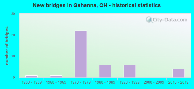
- New bridges - historical statistics
- 11950-1959
- 11960-1969
- 221970-1979
- 61980-1989
- 61990-1999
- 42010-2019
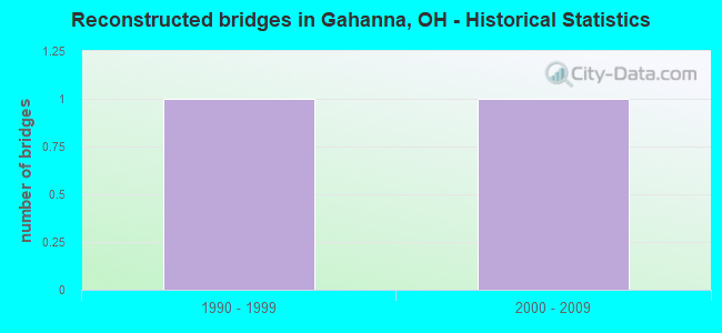
- Reconstructed bridges - Historical Statistics
- 11990-1999
- 12000-2009
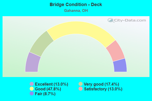
- Bridge Condition - Deck
- 13.0%Excellent
- 17.4%Very good
- 47.8%Good
- 13.0%Satisfactory
- 8.7%Fair

- Bridge Condition - Superstructure
- 17.4%Excellent
- 21.7%Very good
- 43.5%Good
- 13.0%Satisfactory
- 4.3%Fair
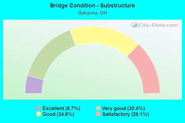
- Bridge Condition - Substructure
- 8.7%Excellent
- 30.4%Very good
- 34.8%Good
- 26.1%Satisfactory
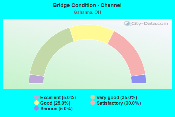
- Bridge Condition - Channel
- 5.0%Excellent
- 35.0%Very good
- 25.0%Good
- 30.0%Satisfactory
- 5.0%Serious
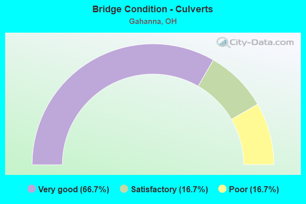
- Bridge Condition - Culverts
- 66.7%Very good
- 16.7%Satisfactory
- 16.7%Poor
Find on map >> Show street view
Structure Number: 2503395, Location: 0.05 MI S OF SR317 (Lat: 40.018900, Lng: -82.880489), Route carried "on" structure: US 62, Year Built: 1966, Status: Open, Structure Length: 6.18m (20.28ft), Average Daily Traffic: 9,432 (year 2015), Truck Traffic: 2%, Average Future Daily Traffic: 13,092 (year 2035), Design Load: HS 20, Features Intersected: BIG WALNUT CREEK
Minimum Vertical Clearance: 30+ m (98+ ft), Kilometerpoint: 38.270, Lanes on structure: 4, Base Highway Network: Yes, Owner: State Highway Agency, Approaching Roadway Width: 21.6m (70.9ft), Skew: 22 degrees, Material/Design: Concrete continuous, Design/Construction: Slab, Number Of Spans In Main Unit: 4, Length of Maximum Span: 16.8m (55.1ft), Curb or Sidewalk Widths: Left: 1.5m (4.9ft), Right: 1.5m (4.9ft), Curb-To-Curb Width: 18.0m (59.1ft), Out-to-Out Width: 21.6m (70.9ft)
Condition: Deck: Good, Superstructure: Good, Substructure: Very good, Channel: Very good, Operating Rating: 42.1 metric tons, Method Used To Determine Operating Rating: Load Factor (LF) rating reported by rating factor (RF) method using MS18 loading, Inventory Rating: 32.4 metric tons, Method Used To Determine Inventory Rating: Load Factor (LF) rating reported by rating factor (RF) method using MS18 loading, Structural Evaluation: Better than present minimum criteria, Deck Geometry: Somewhat better than minimum adequacy, Waterway Adequacy: Equal to present desirable criteria, Approach Roadway Alignment: Better than present minimum criteria, Designated Inspection Frequency: Every 24 months, Inspection Date: April 2020, Deck Structure Type: Concrete Cast-file-Place, Wearing Surface/Protective System: Wearing Surface: Bituminous
Find on map >> Show street view
Structure Number: 2503417, Location: 0.64 MI N OF STELZER RD (Lat: 40.012600, Lng: -82.902481), Route carried "on" structure: US 62, Year Built: 1973, Status: Open, Structure Length: 9.76m (32.02ft), Average Daily Traffic: 23,200 (year 2015), Truck Traffic: 2%, Average Future Daily Traffic: 32,202 (year 2035), Design Load: HS 20+Mod, Features Intersected: OVER I-270
Minimum Vertical Clearance: 4.60m (15.09ft), Kilometerpoint: 35.132, Lanes on structure: 3, Lanes under structure: 7, Base Highway Network: Yes, Owner: State Highway Agency, Approaching Roadway Width: 12.8m (42.0ft), Skew: 2 degrees, Material/Design: Steel continuous, Design/Construction: Stringer/Multi-beam, Number Of Spans In Main Unit: 4, Length of Maximum Span: 29.0m (95.1ft), Curb-To-Curb Width: 17.7m (58.1ft), Out-to-Out Width: 18.3m (60.0ft)
Condition: Deck: Excellent, Superstructure: Excellent, Substructure: Excellent, Operating Rating: 51.8 metric tons, Method Used To Determine Operating Rating: Allowable Stress (AS) rating reported by rating factor (RF) method using MS18 loading, Inventory Rating: 29.2 metric tons, Method Used To Determine Inventory Rating: Allowable Stress (AS) rating reported by rating factor (RF) method using MS18 loading, Structural Evaluation: Better than present minimum criteria, Deck Geometry: Equal to present minimum criteria, Underclear: Meets minimum limits, Approach Roadway Alignment: Equal to present desirable criteria, Designated Inspection Frequency: Every 24 months, Inspection Date: October 2021, Deck Structure Type: Concrete Cast-file-Place, Wearing Surface/Protective System: Wearing Surface: Integral Concrete
Find on map >> Show street view
Structure Number: 2503433, Location: 0.62 MI N OF STELZER RD (Lat: 40.015739, Lng: -82.903689), Route carried "on" structure: US 62, Year Built: 1973, Status: Open, Structure Length: 11.31m (37.11ft), Average Daily Traffic: 23,200 (year 2015), Truck Traffic: 2%, Average Future Daily Traffic: 32,202 (year 2035), Design Load: HS 20+Mod, Features Intersected: OVER I-270
Minimum Vertical Clearance: 30+ m (98+ ft), Kilometerpoint: 35.100, Lanes on structure: 4, Lanes under structure: 8, Base Highway Network: Yes, Owner: State Highway Agency, Approaching Roadway Width: 11.0m (36.1ft), Skew: 13 degrees, Material/Design: Steel continuous, Design/Construction: Stringer/Multi-beam, Number Of Spans In Main Unit: 4, Length of Maximum Span: 35.8m (117.5ft), Curb-To-Curb Width: 26.8m (87.9ft), Out-to-Out Width: 27.4m (89.9ft)
Condition: Deck: Good, Superstructure: Good, Substructure: Good, Operating Rating: 35.6 metric tons, Method Used To Determine Operating Rating: Allowable Stress (AS) rating reported by rating factor (RF) method using MS18 loading, Inventory Rating: 32.4 metric tons, Method Used To Determine Inventory Rating: Allowable Stress (AS) rating reported by rating factor (RF) method using MS18 loading, Structural Evaluation: Better than present minimum criteria, Deck Geometry: Superior to present desirable criteria, Underclear: High priority of corrective action, Approach Roadway Alignment: Equal to present desirable criteria, Designated Inspection Frequency: Every 24 months, Inspection Date: October 2021, Deck Structure Type: Concrete Cast-file-Place, Wearing Surface/Protective System: Wearing Surface: Integral Concrete
Find on map >> Show street view
Structure Number: 2511754, Location: 3.91 MI N OF SR16 (Lat: 40.011550, Lng: -82.899431), Route carried "on" structure: Ramp Interstate 270, Year Built: 1973, Status: Open, Structure Length: 4.31m (14.14ft), Average Daily Traffic: 67,130 (year 1990), Average Future Daily Traffic: 93,176 (year 2010), Design Load: HS 20+Mod, Features Intersected: RAMP I OVER JOHNSTOWN RD
Minimum Vertical Clearance: 30+ m (98+ ft), Kilometerpoint: 57.325, Lanes on structure: 2, Lanes under structure: 2, Owner: State Highway Agency, Approaching Roadway Width: 13.4m (44.0ft), Skew: 1 degrees, Material/Design: Concrete continuous, Design/Construction: Slab, Number Of Spans In Main Unit: 3, Length of Maximum Span: 16.4m (53.8ft), Curb-To-Curb Width: 13.7m (44.9ft), Out-to-Out Width: 14.3m (46.9ft)
Condition: Deck: Very good, Superstructure: Very good, Substructure: Satisfactory, Operating Rating: 74.5 metric tons, Method Used To Determine Operating Rating: Load Factor (LF) rating reported by rating factor (RF) method using MS18 loading, Inventory Rating: 45.4 metric tons, Method Used To Determine Inventory Rating: Load Factor (LF) rating reported by rating factor (RF) method using MS18 loading, Structural Evaluation: Equal to present minimum criteria, Deck Geometry: Superior to present desirable criteria, Underclear: High priority of corrective action, Approach Roadway Alignment: Equal to present desirable criteria, Designated Inspection Frequency: Every 12 months, Inspection Date: June 2021, Deck Structure Type: Concrete Cast-file-Place, Wearing Surface/Protective System: Wearing Surface: Integral Concrete
Find on map >> Show street view
Structure Number: 25118, Location: 2.59 MI N OF SR16 (Lat: 40.006939, Lng: -82.875111), Route carried "on" structure: Interstate 270, Year Built: 1973, Status: Open, Structure Length: 8.92m (29.27ft), Average Daily Traffic: 74,396 (year 2015), Truck Traffic: 13%, Average Future Daily Traffic: 103,262 (year 2035), Design Load: HS 20+Mod, Features Intersected: BIG WALNUT CREEK
Minimum Vertical Clearance: 30+ m (98+ ft), Kilometerpoint: 59.449, Lanes on structure: 4, Base Highway Network: Yes, Owner: State Highway Agency, Approaching Roadway Width: 20.7m (67.9ft), Skew: 2 degrees, Material/Design: Prestressed concrete, Design/Construction: Stringer/Multi-beam, Number Of Spans In Main Unit: 4, Length of Maximum Span: 21.6m (70.9ft), Curb-To-Curb Width: 22.9m (75.1ft), Out-to-Out Width: 23.5m (77.1ft)
Condition: Deck: Good, Superstructure: Good, Substructure: Satisfactory, Channel: Serious, Operating Rating: 87.5 metric tons, Method Used To Determine Operating Rating: Allowable Stress (AS) rating reported by rating factor (RF) method using MS18 loading, Inventory Rating: 45.4 metric tons, Method Used To Determine Inventory Rating: Allowable Stress (AS) rating reported by rating factor (RF) method using MS18 loading, Structural Evaluation: Equal to present minimum criteria, Deck Geometry: Superior to present desirable criteria, Waterway Adequacy: Equal to present desirable criteria, Approach Roadway Alignment: Equal to present desirable criteria, Designated Inspection Frequency: Every 12 months, Inspection Date: June 2021, Deck Structure Type: Concrete Cast-file-Place, Wearing Surface/Protective System: Wearing Surface: Integral Concrete
Find on map >> Show street view
Structure Number: 2511819, Location: 2.59 MI N OF SR16 (Lat: 40.006750, Lng: -82.875139), Route carried "on" structure: Interstate 270, Year Built: 1973, Status: Open, Structure Length: 8.92m (29.27ft), Average Daily Traffic: 74,396 (year 2015), Truck Traffic: 13%, Average Future Daily Traffic: 103,262 (year 2035), Design Load: HS 20+Mod, Features Intersected: BIG WALNUT CREEK
Minimum Vertical Clearance: 30+ m (98+ ft), Kilometerpoint: 59.449, Lanes on structure: 4, Base Highway Network: Yes, Owner: State Highway Agency, Approaching Roadway Width: 20.7m (67.9ft), Skew: 2 degrees, Material/Design: Prestressed concrete, Design/Construction: Stringer/Multi-beam, Number Of Spans In Main Unit: 4, Length of Maximum Span: 21.6m (70.9ft), Curb-To-Curb Width: 24.4m (80.1ft), Out-to-Out Width: 25.0m (82.0ft)
Condition: Deck: Satisfactory, Superstructure: Good, Substructure: Satisfactory, Channel: Satisfactory, Operating Rating: 90.7 metric tons, Method Used To Determine Operating Rating: Load Factor (LF) rating reported by rating factor (RF) method using MS18 loading, Inventory Rating: 48.6 metric tons, Method Used To Determine Inventory Rating: Load Factor (LF) rating reported by rating factor (RF) method using MS18 loading, Structural Evaluation: Equal to present minimum criteria, Deck Geometry: Superior to present desirable criteria, Waterway Adequacy: Better than present minimum criteria, Approach Roadway Alignment: Better than present minimum criteria, Designated Inspection Frequency: Every 12 months, Inspection Date: June 2021, Deck Structure Type: Concrete Cast-file-Place, Wearing Surface/Protective System: Wearing Surface: Latex Concrete
Find on map >> Show street view
Structure Number: 2511843, Location: 3.63 MI N OF SR16 (Lat: 40.008281, Lng: -82.894569), Route carried "on" structure: City street GOSHN, Year Built: 1973, Status: Open, Structure Length: 8.70m (28.54ft), Average Daily Traffic: 90 (year 1970), Average Future Daily Traffic: 125 (year 1990), Design Load: HS 20+Mod, Features Intersected: I270 & I670W/US62 RMP, Facility Carried by Structure: GOSHEN LANE
Minimum Vertical Clearance: 30+ m (98+ ft), Kilometerpoint: 0.029, Lanes on structure: 2, Lanes under structure: 9, Owner: State Highway Agency, Approaching Roadway Width: 13.4m (44.0ft), Material/Design: Steel continuous, Design/Construction: Stringer/Multi-beam, Number Of Spans In Main Unit: 3, Length of Maximum Span: 33.2m (108.9ft), Curb-To-Curb Width: 13.4m (44.0ft), Out-to-Out Width: 14.0m (45.9ft)
Condition: Deck: Good, Superstructure: Very good, Substructure: Very good, Operating Rating: 35.6 metric tons, Method Used To Determine Operating Rating: Allowable Stress (AS) rating reported by rating factor (RF) method using MS18 loading, Inventory Rating: 32.4 metric tons, Method Used To Determine Inventory Rating: Allowable Stress (AS) rating reported by rating factor (RF) method using MS18 loading, Structural Evaluation: Equal to present desirable criteria, Deck Geometry: Superior to present desirable criteria, Underclear: High priority of corrective action, Approach Roadway Alignment: Better than present minimum criteria, Designated Inspection Frequency: Every 24 months, Inspection Date: June 2021, Deck Structure Type: Concrete Cast-file-Place, Wearing Surface/Protective System: Wearing Surface: Integral Concrete
Find on map >> Show street view
Structure Number: 2511991, Location: 1 MI N OF SR16 (Lat: 39.992219, Lng: -82.857169), Route carried "on" structure: City street CLAYC, Year Built: 1974, Status: Open, Structure Length: 9.82m (32.22ft), Average Daily Traffic: 4,500 (year 1970), Truck Traffic: 5%, Average Future Daily Traffic: 6,246 (year 1990), Design Load: H 20, Features Intersected: IR-270
Minimum Vertical Clearance: 30+ m (98+ ft), Kilometerpoint: 0.002, Lanes on structure: 2, Lanes under structure: 8, Owner: State Highway Agency, Approaching Roadway Width: 11.0m (36.1ft), Skew: 1 degrees, Material/Design: Steel continuous, Design/Construction: Stringer/Multi-beam, Number Of Spans In Main Unit: 4, Length of Maximum Span: 28.3m (92.8ft), Curb-To-Curb Width: 11.0m (36.1ft), Out-to-Out Width: 11.6m (38.1ft)
Condition: Deck: Excellent, Superstructure: Excellent, Substructure: Excellent, Operating Rating: 35.6 metric tons, Method Used To Determine Operating Rating: Allowable Stress (AS) rating reported by rating factor (RF) method using MS18 loading, Inventory Rating: 32.4 metric tons, Method Used To Determine Inventory Rating: Allowable Stress (AS) rating reported by rating factor (RF) method using MS18 loading, Structural Evaluation: Equal to present desirable criteria, Deck Geometry: Somewhat better than minimum adequacy, Underclear: High priority of corrective action, Approach Roadway Alignment: Equal to present desirable criteria, Designated Inspection Frequency: Every 24 months, Inspection Date: July 2020, Deck Structure Type: Concrete Cast-file-Place, Wearing Surface/Protective System: Wearing Surface: Bituminous, Membrane: Built-up
Find on map >> Show street view
Structure Number: 2512084, Location: 4.15 MI N OF SR16 (Lat: 40.012761, Lng: -82.902919), Route carried "on" structure: Ramp Interstate 270, Year Built: 1972, Status: Open, Structure Length: 15.10m (49.54ft), Average Daily Traffic: 135,680 (year 2010), Truck Traffic: 11%, Average Future Daily Traffic: 188,324 (year 2030), Design Load: HS 20+Mod, Features Intersected: OVER RAMP I 270N-62W
Minimum Vertical Clearance: 30+ m (98+ ft), Kilometerpoint: 56.939, Lanes on structure: 2, Lanes under structure: 7, Owner: State Highway Agency, Approaching Roadway Width: 12.8m (42.0ft), Skew: 9 degrees, Material/Design: Steel continuous, Design/Construction: Stringer/Multi-beam, Number Of Spans In Main Unit: 4, Length of Maximum Span: 44.0m (144.4ft), Curb-To-Curb Width: 12.8m (42.0ft), Out-to-Out Width: 13.4m (44.0ft)
Condition: Deck: Good, Superstructure: Good, Substructure: Satisfactory, Operating Rating: 48.6 metric tons, Method Used To Determine Operating Rating: Load and Resistance Factor Rating (LRFR) rating reported by rating factor(RF) method using HL-93 loadings, Inventory Rating: 35.6 metric tons, Method Used To Determine Inventory Rating: Load and Resistance Factor Rating (LRFR) rating reported by rating factor(RF) method using HL-93 loadings, Structural Evaluation: Equal to present minimum criteria, Deck Geometry: Superior to present desirable criteria, Underclear: Meets minimum limits, Approach Roadway Alignment: Better than present minimum criteria, Designated Inspection Frequency: Every 12 months, Inspection Date: June 2021, Deck Structure Type: Concrete Cast-file-Place, Wearing Surface/Protective System: Wearing Surface: Integral Concrete
Find on map >> Show street view
Structure Number: 2512343, Location: 0.5 MI E OF SR-317 (Lat: 39.999500, Lng: -82.858239), Route carried "on" structure: County highway C205B, Year Built: 2011, Status: Open, Structure Length: 6.82m (22.38ft), Average Daily Traffic: 7,245 (year 2015), Truck Traffic: 5%, Average Future Daily Traffic: 10,056 (year 2035), Design Load: HL 93, Features Intersected: IR-270, Facility Carried by Structure: TECH CENTER DRIVE
Minimum Vertical Clearance: 30+ m (98+ ft), Kilometerpoint: 0.896, Lanes on structure: 2, Lanes under structure: 8, Owner: State Highway Agency, Approaching Roadway Width: 20.4m (66.9ft), Material/Design: Steel continuous, Design/Construction: Stringer/Multi-beam, Number Of Spans In Main Unit: 2, Length of Maximum Span: 33.8m (110.9ft), Curb or Sidewalk Widths: Left: 1.6m (5.2ft), Right: 1.6m (5.2ft), Curb-To-Curb Width: 19.8m (65.0ft), Out-to-Out Width: 23.7m (77.8ft)
Condition: Deck: Good, Superstructure: Good, Substructure: Good, Operating Rating: 97.2 metric tons, Method Used To Determine Operating Rating: Load Factor (LF) rating reported by rating factor (RF) method using MS18 loading, Inventory Rating: 64.8 metric tons, Method Used To Determine Inventory Rating: Load Factor (LF) rating reported by rating factor (RF) method using MS18 loading, Structural Evaluation: Better than present minimum criteria, Deck Geometry: Superior to present desirable criteria, Underclear: Better than present minimum criteria, Approach Roadway Alignment: Better than present minimum criteria, Designated Inspection Frequency: Every 24 months, Inspection Date: June 2021, Deck Structure Type: Concrete Cast-file-Place, Wearing Surface/Protective System: Wearing Surface: Monolithic Concrete, Deck Protection: Epoxy Coated Reinforcing
Find on map >> Show street view
Structure Number: 251664, Location: 1.05 MI N OF 5TH AVE (Lat: 40.004319, Lng: -82.867750), Route carried "on" structure: State highway 317, Year Built: 1973, Status: Open, Structure Length: 7.60m (24.93ft), Average Daily Traffic: 30,653 (year 2015), Truck Traffic: 8%, Average Future Daily Traffic: 42,546 (year 2035), Design Load: HS 20+Mod, Features Intersected: OVER I-270
Minimum Vertical Clearance: 30+ m (98+ ft), Kilometerpoint: 27.681, Lanes on structure: 4, Lanes under structure: 10, Base Highway Network: Yes, Owner: State Highway Agency, Approaching Roadway Width: 28.0m (91.9ft), Skew: 1 degrees, Material/Design: Steel continuous, Design/Construction: Stringer/Multi-beam, Number Of Spans In Main Unit: 2, Length of Maximum Span: 36.6m (120.1ft), Curb-To-Curb Width: 28.0m (91.9ft), Out-to-Out Width: 28.7m (94.2ft)
Condition: Deck: Fair, Superstructure: Satisfactory, Substructure: Good, Operating Rating: 42.1 metric tons, Method Used To Determine Operating Rating: Load Factor (LF) rating reported by rating factor (RF) method using MS18 loading, Inventory Rating: 32.4 metric tons, Method Used To Determine Inventory Rating: Load Factor (LF) rating reported by rating factor (RF) method using MS18 loading, Structural Evaluation: Equal to present minimum criteria, Deck Geometry: Superior to present desirable criteria, Underclear: High priority of corrective action, Approach Roadway Alignment: Equal to present desirable criteria, Designated Inspection Frequency: Every 12 months, Inspection Date: August 2021, Deck Structure Type: Concrete Cast-file-Place, Wearing Surface/Protective System: Wearing Surface: Bituminous, Membrane: Built-up
Find on map >> Show street view
Structure Number: 2516659, Location: 1.24 MI N OF IR270 (Lat: 40.018500, Lng: -82.871731), Route carried "on" structure: State highway 317, Year Built: 1957, Year Reconstructed: 1999, Status: Open, Structure Length: 3.61m (11.84ft), Average Daily Traffic: 22,368 (year 2015), Truck Traffic: 8%, Average Future Daily Traffic: 31,047 (year 2035), Design Load: HS 20+Mod, Features Intersected: ROCKY FORK CREEK
Minimum Vertical Clearance: 30+ m (98+ ft), Kilometerpoint: 29.676, Lanes on structure: 2, Base Highway Network: Yes, Owner: State Highway Agency, Approaching Roadway Width: 13.4m (44.0ft), Skew: 1 degrees, Material/Design: Concrete continuous, Design/Construction: Slab, Number Of Spans In Main Unit: 3, Length of Maximum Span: 13.7m (44.9ft), Curb or Sidewalk Widths: Left: 1.8m (5.9ft), Right: 1.8m (5.9ft), Curb-To-Curb Width: 18.9m (62.0ft), Out-to-Out Width: 23.5m (77.1ft)
Condition: Deck: Very good, Superstructure: Excellent, Substructure: Good, Channel: Excellent, Operating Rating: 68.0 metric tons, Method Used To Determine Operating Rating: Load Factor (LF) rating reported by rating factor (RF) method using MS18 loading, Inventory Rating: 38.9 metric tons, Method Used To Determine Inventory Rating: Load Factor (LF) rating reported by rating factor (RF) method using MS18 loading, Structural Evaluation: Better than present minimum criteria, Deck Geometry: Superior to present desirable criteria, Waterway Adequacy: Equal to present desirable criteria, Approach Roadway Alignment: Equal to present desirable criteria, Designated Inspection Frequency: Every 24 months, Inspection Date: July 2021, Deck Structure Type: Concrete Cast-file-Place, Wearing Surface/Protective System: Wearing Surface: Monolithic Concrete, Membrane: Built-up
Find on map >> Show street view
Structure Number: 2516721, Location: SR317 OVER SYCOMORE RUN (Lat: 40.018581, Lng: -82.874150), Route carried "on" structure: State highway 317, Year Built: 1999, Status: Open, Structure Length: 0.73m (2.40ft), Average Daily Traffic: 22,368 (year 2015), Truck Traffic: 8%, Average Future Daily Traffic: 31,047 (year 2035), Design Load: HS 20+Mod, Features Intersected: SYCAMORE RUN, Facility Carried by Structure: NON-HIGHWAY
Minimum Vertical Clearance: 30+ m (98+ ft), Kilometerpoint: 29.998, Lanes on structure: 2, Base Highway Network: Yes, Owner: State Highway Agency, Approaching Roadway Width: 18.0m (59.1ft), Material/Design: Concrete, Design/Construction: Culvert, Number Of Spans In Main Unit: 1, Length of Maximum Span: 7.3m (24.0ft)
Condition: Channel: Good, Culverts: Very good, Operating Rating: 97.2 metric tons, Method Used To Determine Operating Rating: Load Factor (LF) rating reported by rating factor (RF) method using MS18 loading, Inventory Rating: 64.8 metric tons, Method Used To Determine Inventory Rating: Load Factor (LF) rating reported by rating factor (RF) method using MS18 loading, Structural Evaluation: Equal to present desirable criteria, Waterway Adequacy: Equal to present minimum criteria, Approach Roadway Alignment: Equal to present minimum criteria, Designated Inspection Frequency: Every 24 months, Inspection Date: July 2021, Wearing Surface/Protective System: Membrane: Epoxy, Deck Protection: Epoxy Coated Reinforcing
Find on map >> Show street view
Structure Number: 2532174, Location: 0.1 MI E. OF REY-N.ALBANY (Lat: 40.029861, Lng: -82.812881), Route carried "on" structure: County highway T0203, Year Built: 1973, Status: Open, Structure Length: 4.27m (14.01ft), Average Daily Traffic: 2,244 (year 2015), Truck Traffic: 5%, Average Future Daily Traffic: 3,115 (year 2035), Design Load: HS 20, Features Intersected: BLACKLICK CREEK (HAVENS), Facility Carried by Structure: HAVENS RD
Minimum Vertical Clearance: 30+ m (98+ ft), Kilometerpoint: 2.382, Lanes on structure: 2, Owner: County Highway Agency, Approaching Roadway Width: 11.9m (39.0ft), Skew: 4 degrees, Material/Design: Prestressed concrete, Design/Construction: Box Beam or Girders - Multiple, Number Of Spans In Main Unit: 3, Length of Maximum Span: 14.9m (48.9ft), Curb-To-Curb Width: 11.1m (36.4ft), Out-to-Out Width: 11.1m (36.4ft)
Condition: Deck: Satisfactory, Superstructure: Satisfactory, Substructure: Satisfactory, Channel: Good, Operating Rating: 45.4 metric tons, Method Used To Determine Operating Rating: Load Factor (LF) rating reported by rating factor (RF) method using MS18 loading, Inventory Rating: 25.9 metric tons, Method Used To Determine Inventory Rating: Load Factor (LF) rating reported by rating factor (RF) method using MS18 loading, Structural Evaluation: Equal to present minimum criteria, Deck Geometry: Somewhat better than minimum adequacy, Waterway Adequacy: Equal to present desirable criteria, Approach Roadway Alignment: Equal to present desirable criteria, Designated Inspection Frequency: Every 12 months, Inspection Date: December 2021, Deck Structure Type: Concrete Cast-file-Place, Wearing Surface/Protective System: Wearing Surface: Bituminous, Membrane: Built-up
Find on map >> Show street view
Structure Number: 2534274, Location: 0.7 MI NORTH OF BROAD ST (Lat: 39.989061, Lng: -82.842500), Route carried "on" structure: County highway C0208, Year Built: 1974, Status: Open, Structure Length: 6.95m (22.80ft), Average Daily Traffic: 7,245 (year 2015), Truck Traffic: 5%, Average Future Daily Traffic: 10,056 (year 2035), Design Load: HS 20, Features Intersected: CSXT RR(TAYLOR STA.), Facility Carried by Structure: TAYLOR STATION RD
Minimum Vertical Clearance: 30+ m (98+ ft), Kilometerpoint: 1.143, Lanes on structure: 2, Owner: County Highway Agency, Approaching Roadway Width: 7.9m (25.9ft), Skew: 4 degrees, Material/Design: Steel continuous, Design/Construction: Stringer/Multi-beam, Number Of Spans In Main Unit: 3, Length of Maximum Span: 27.4m (89.9ft), Curb-To-Curb Width: 9.8m (32.2ft), Out-to-Out Width: 10.2m (33.5ft)
Condition: Deck: Good, Superstructure: Very good, Substructure: Very good, Operating Rating: 58.3 metric tons, Method Used To Determine Operating Rating: Load Factor (LF) rating reported by rating factor (RF) method using MS18 loading, Inventory Rating: 35.6 metric tons, Method Used To Determine Inventory Rating: Load Factor (LF) rating reported by rating factor (RF) method using MS18 loading, Structural Evaluation: Equal to present desirable criteria, Deck Geometry: Meets minimum limits, Underclear: Better than present minimum criteria, Approach Roadway Alignment: Somewhat better than minimum adequacy, Designated Inspection Frequency: Every 24 months, Inspection Date: December 2021, Deck Structure Type: Concrete Cast-file-Place, Wearing Surface/Protective System: Wearing Surface: Monolithic Concrete
Find on map >> Show street view
Structure Number: 2534606, Location: 0.3 MI N.OF HAVENS CORN. (Lat: 40.021889, Lng: -82.866281), Route carried "on" structure: County highway C0103, Year Built: 1983, Status: Open, Structure Length: 5.63m (18.47ft), Average Daily Traffic: 22,509 (year 2015), Truck Traffic: 7%, Average Future Daily Traffic: 31,242 (year 2035), Design Load: HS 20+Mod, Features Intersected: ROCKY FORK(HAMILTON RD), Facility Carried by Structure: HAMILTON RD
Minimum Vertical Clearance: 30+ m (98+ ft), Kilometerpoint: 19.135, Lanes on structure: 4, Base Highway Network: Yes, Owner: County Highway Agency, Approaching Roadway Width: 15.9m (52.2ft), Skew: 3 degrees, Material/Design: Prestressed concrete, Design/Construction: Box Beam or Girders - Multiple, Number Of Spans In Main Unit: 4, Length of Maximum Span: 15.2m (49.9ft), Curb or Sidewalk Widths: Left: 1.5m (4.9ft), Right: 1.5m (4.9ft), Curb-To-Curb Width: 15.9m (52.2ft), Out-to-Out Width: 19.7m (64.6ft)
Condition: Deck: Good, Superstructure: Satisfactory, Substructure: Good, Channel: Satisfactory, Operating Rating: 97.2 metric tons, Method Used To Determine Operating Rating: Load Factor (LF) rating reported by rating factor (RF) method using MS18 loading, Inventory Rating: 64.8 metric tons, Method Used To Determine Inventory Rating: Load Factor (LF) rating reported by rating factor (RF) method using MS18 loading, Structural Evaluation: Equal to present minimum criteria, Deck Geometry: Meets minimum limits, Waterway Adequacy: Equal to present desirable criteria, Approach Roadway Alignment: Equal to present desirable criteria, Designated Inspection Frequency: Every 12 months, Inspection Date: December 2021, Deck Structure Type: Concrete Cast-file-Place, Wearing Surface/Protective System: Wearing Surface: Bituminous, Membrane: Built-up
Find on map >> Show street view
Structure Number: 2534703, Location: JUST WEST OF HAVENS RD (Lat: 40.033111, Lng: -82.839631), Route carried "on" structure: County highway C0095, Year Built: 1984, Status: Open, Structure Length: 4.60m (15.09ft), Average Daily Traffic: 5,955 (year 2015), Truck Traffic: 7%, Average Future Daily Traffic: 8,266 (year 2035), Design Load: HS 20+Mod, Features Intersected: ROCKY FORK(CLARK STATE), Facility Carried by Structure: CLARK STATE RD
Minimum Vertical Clearance: 30+ m (98+ ft), Kilometerpoint: 2.607, Lanes on structure: 2, Owner: County Highway Agency, Approaching Roadway Width: 12.2m (40.0ft), Skew: 4 degrees, Material/Design: Steel continuous, Design/Construction: Stringer/Multi-beam, Number Of Spans In Main Unit: 3, Length of Maximum Span: 16.8m (55.1ft), Curb-To-Curb Width: 9.8m (32.2ft), Out-to-Out Width: 9.8m (32.2ft)
Condition: Deck: Satisfactory, Superstructure: Good, Substructure: Good, Channel: Very good, Operating Rating: 42.1 metric tons, Method Used To Determine Operating Rating: Load Factor (LF) rating reported by rating factor (RF) method using MS18 loading, Inventory Rating: 32.4 metric tons, Method Used To Determine Inventory Rating: Load Factor (LF) rating reported by rating factor (RF) method using MS18 loading, Structural Evaluation: Better than present minimum criteria, Deck Geometry: Meets minimum limits, Waterway Adequacy: Equal to present desirable criteria, Approach Roadway Alignment: Equal to present desirable criteria, Designated Inspection Frequency: Every 12 months, Inspection Date: December 2021, Deck Structure Type: Concrete Cast-file-Place, Wearing Surface/Protective System: Wearing Surface: Monolithic Concrete, Deck Protection: Epoxy Coated Reinforcing
Find on map >> Show street view
Structure Number: 2534754, Location: 0.1 MI E.OF REYN-NEW ALB. (Lat: 40.043581, Lng: -82.807789), Route carried "on" structure: County highway C0095, Year Built: 1985, Status: Open, Structure Length: 3.72m (12.20ft), Average Daily Traffic: 5,955 (year 2015), Truck Traffic: 7%, Average Future Daily Traffic: 8,266 (year 2035), Design Load: HS 20, Features Intersected: BLACKLICK CR (CLARK ST), Facility Carried by Structure: CLARK STATE RD
Minimum Vertical Clearance: 30+ m (98+ ft), Kilometerpoint: 5.890, Lanes on structure: 2, Owner: County Highway Agency, Approaching Roadway Width: 12.2m (40.0ft), Skew: 3 degrees, Material/Design: Prestressed concrete, Design/Construction: Box Beam or Girders - Multiple, Number Of Spans In Main Unit: 3, Length of Maximum Span: 14.0m (45.9ft), Curb-To-Curb Width: 12.3m (40.4ft), Out-to-Out Width: 12.3m (40.4ft)
Condition: Deck: Good, Superstructure: Good, Substructure: Very good, Channel: Good, Operating Rating: 45.4 metric tons, Method Used To Determine Operating Rating: Load Factor (LF) rating reported by rating factor (RF) method using MS18 loading, Inventory Rating: 25.9 metric tons, Method Used To Determine Inventory Rating: Load Factor (LF) rating reported by rating factor (RF) method using MS18 loading, Structural Evaluation: Equal to present minimum criteria, Deck Geometry: Somewhat better than minimum adequacy, Waterway Adequacy: Better than present minimum criteria, Approach Roadway Alignment: Equal to present desirable criteria, Designated Inspection Frequency: Every 24 months, Inspection Date: December 2021, Deck Structure Type: Concrete Cast-file-Place, Wearing Surface/Protective System: Wearing Surface: Bituminous, Membrane: Built-up
Find on map >> Show street view
Structure Number: 2535017, Location: JUST EAST OF U.S. 62 (Lat: 40.054350, Lng: -82.840981), Route carried "on" structure: County highway C0017, Year Built: 1988, Year Reconstructed: 2007, Status: Open, Structure Length: 3.84m (12.60ft), Average Daily Traffic: 26,358 (year 2015), Truck Traffic: 7%, Average Future Daily Traffic: 36,585 (year 2035), Design Load: HS 20+Mod, Features Intersected: ROCKY FORK CREEK (MORSE), Facility Carried by Structure: MORSE RD
Minimum Vertical Clearance: 30+ m (98+ ft), Kilometerpoint: 13.663, Lanes on structure: 4, Owner: County Highway Agency, Approaching Roadway Width: 15.5m (50.9ft), Skew: 2 degrees, Material/Design: Prestressed concrete, Design/Construction: Box Beam or Girders - Multiple, Number Of Spans In Main Unit: 3, Length of Maximum Span: 15.2m (49.9ft), Curb or Sidewalk Widths: Left: 1.5m (4.9ft), Right: 3.0m (9.8ft), Curb-To-Curb Width: 19.5m (64.0ft), Out-to-Out Width: 25.5m (83.7ft)
Condition: Deck: Very good, Superstructure: Very good, Substructure: Very good, Channel: Very good, Operating Rating: 42.1 metric tons, Method Used To Determine Operating Rating: Allowable Stress (AS) rating reported by rating factor (RF) method using MS18 loading, Inventory Rating: 32.4 metric tons, Method Used To Determine Inventory Rating: Allowable Stress (AS) rating reported by rating factor (RF) method using MS18 loading, Structural Evaluation: Equal to present desirable criteria, Deck Geometry: Better than present minimum criteria, Waterway Adequacy: Equal to present desirable criteria, Approach Roadway Alignment: Better than present minimum criteria, Designated Inspection Frequency: Every 24 months, Inspection Date: December 2021, Deck Structure Type: Concrete Cast-file-Place, Wearing Surface/Protective System: Wearing Surface: Bituminous, Membrane: Preformed Fabric, Deck Protection: Epoxy Coated Reinforcing
Find on map >> Show street view
Structure Number: 2536501, Location: 0.22 Mi South Havens Rd (Lat: 40.026331, Lng: -82.805469), Route carried "on" structure: County highway T2969, Year Built: 1997, Status: Open, Structure Length: 1.11m (3.64ft), Average Daily Traffic: 200 (year 1997), Truck Traffic: 3%, Average Future Daily Traffic: 200 (year 2017), Design Load: HS 20+Mod, Features Intersected: Cole Ditch(Havens Court), Facility Carried by Structure: Havens Court East
Minimum Vertical Clearance: 30+ m (98+ ft), Kilometerpoint: 0.354, Lanes on structure: 2, Owner: County Highway Agency, Approaching Roadway Width: 6.7m (22.0ft), Skew: 4 degrees, Material/Design: Concrete, Design/Construction: Culvert, Number Of Spans In Main Unit: 1, Length of Maximum Span: 9.9m (32.5ft)
Condition: Channel: Good, Culverts: Very good, Operating Rating: 40.5 metric tons, Method Used To Determine Operating Rating: Assigned rating based on Load Factor Design (LFD) reported by rating factor (RF) using MS18 loading, Inventory Rating: 32.4 metric tons, Method Used To Determine Inventory Rating: Assigned rating based on Load Factor Design (LFD) reported by rating factor (RF) using MS18 loading, Structural Evaluation: Equal to present desirable criteria, Waterway Adequacy: Equal to present desirable criteria, Approach Roadway Alignment: Equal to present desirable criteria, Designated Inspection Frequency: Every 12 months, Inspection Date: January 2022
Find on map >> Show street view
Structure Number: 2567369, Location: 0.3 MI. E. OF HAMILTON RD (Lat: 39.999100, Lng: -82.863161), Route carried "on" structure: City street TECHC, Year Built: 2011, Status: Open, Structure Length: 0.73m (2.40ft), Average Daily Traffic: 30,490 (year 2011), Truck Traffic: 6%, Average Future Daily Traffic: 2,791 (year 2031), Design Load: HL 93, Features Intersected: TRIBUTARY TO BIG WALNUT, Facility Carried by Structure: TECH CENTER DRIVE
Minimum Vertical Clearance: 30+ m (98+ ft), Kilometerpoint: 0.451, Lanes on structure: 4, Owner: City or Municipal Highway Agency, Approaching Roadway Width: 21.3m (69.9ft), Material/Design: Concrete, Design/Construction: Culvert, Number Of Spans In Main Unit: 1, Length of Maximum Span: 6.7m (22.0ft), Curb or Sidewalk Widths: Left: 1.5m (4.9ft), Right: 1.5m (4.9ft)
Condition: Channel: Very good, Culverts: Very good, Operating Rating: 81.0 metric tons, Method Used To Determine Operating Rating: Load and Resistance Factor Rating (LRFR) rating reported by rating factor(RF) method using HL-93 loadings, Inventory Rating: 64.8 metric tons, Method Used To Determine Inventory Rating: Load and Resistance Factor Rating (LRFR) rating reported by rating factor(RF) method using HL-93 loadings, Structural Evaluation: Equal to present desirable criteria, Waterway Adequacy: Equal to present desirable criteria, Approach Roadway Alignment: Equal to present desirable criteria, Designated Inspection Frequency: Every 24 months, Inspection Date: July 2021
Find on map >> Show street view
Structure Number: 2576, Location: 80' WEST OF LINCOLN CIR. (Lat: 40.017850, Lng: -82.874319), Route carried "on" structure: City street CSERV, Year Built: 1998, Status: Open, Structure Length: 0.79m (2.59ft), Average Daily Traffic: 500 (year 2020), Truck Traffic: 1%, Average Future Daily Traffic: 2,803 (year 2040), Design Load: HS 20, Features Intersected: SYCAMORE RUN, Facility Carried by Structure: CITY SERVICE DRIVE
Minimum Vertical Clearance: 30+ m (98+ ft), Kilometerpoint: 0.338, Lanes on structure: 2, Owner: City or Municipal Highway Agency, Approaching Roadway Width: 7.9m (25.9ft), Material/Design: Concrete, Design/Construction: Frame, Number Of Spans In Main Unit: 1, Length of Maximum Span: 7.3m (24.0ft), Curb-To-Curb Width: 7.9m (25.9ft), Out-to-Out Width: 8.5m (27.9ft)
Condition: Deck: Very good, Superstructure: Very good, Substructure: Very good, Channel: Very good, Operating Rating: 81.0 metric tons, Method Used To Determine Operating Rating: Load Factor (LF) rating reported by rating factor (RF) method using MS18 loading, Inventory Rating: 48.6 metric tons, Method Used To Determine Inventory Rating: Load Factor (LF) rating reported by rating factor (RF) method using MS18 loading, Structural Evaluation: Equal to present desirable criteria, Deck Geometry: Somewhat better than minimum adequacy, Waterway Adequacy: Better than present minimum criteria, Approach Roadway Alignment: Equal to present minimum criteria, Designated Inspection Frequency: Every 24 months, Inspection Date: July 2021, Deck Structure Type: Other, Wearing Surface/Protective System: Wearing Surface: Bituminous
Find on map >> Show street view
Structure Number: 2576015, Location: E. OF CHERRY BOTTOM (Lat: 40.036439, Lng: -82.873739), Route carried "on" structure: City street CROSS, Year Built: 1989, Status: Open, Structure Length: 0.98m (3.22ft), Average Daily Traffic: 125 (year 2006), Truck Traffic: 5%, Average Future Daily Traffic: 174 (year 2026), Design Load: HS 20+Mod, Features Intersected: BEEM DITCH(CROSSING CRK)
Minimum Vertical Clearance: 30+ m (98+ ft), Kilometerpoint: 0.628, Lanes on structure: 2, Owner: City or Municipal Highway Agency, Approaching Roadway Width: 7.9m (25.9ft), Material/Design: Concrete, Design/Construction: Frame, Number Of Spans In Main Unit: 1, Length of Maximum Span: 9.1m (29.9ft), Curb or Sidewalk Widths: Left: 1.2m (3.9ft), Right: 1.2m (3.9ft), Curb-To-Curb Width: 7.9m (25.9ft), Out-to-Out Width: 12.2m (40.0ft)
Condition: Deck: Fair, Superstructure: Fair, Substructure: Good, Channel: Satisfactory, Operating Rating: 61.6 metric tons, Method Used To Determine Operating Rating: Load Factor (LF) rating reported by rating factor (RF) method using MS18 loading, Inventory Rating: 35.6 metric tons, Method Used To Determine Inventory Rating: Load Factor (LF) rating reported by rating factor (RF) method using MS18 loading, Structural Evaluation: Somewhat better than minimum adequacy, Deck Geometry: Somewhat better than minimum adequacy, Waterway Adequacy: Equal to present desirable criteria, Approach Roadway Alignment: Equal to present minimum criteria, Designated Inspection Frequency: Every 12 months, Inspection Date: June 2021, Deck Structure Type: Concrete Cast-file-Place, Wearing Surface/Protective System: Wearing Surface: Bituminous
Find on map >> Show street view
Structure Number: 2576074, Location: BTWN CHRY BTM & E CHESTER (Lat: 40.039831, Lng: -82.873481), Route carried "on" structure: City street ACDMY, Year Built: 1972, Status: Open, Structure Length: 0.73m (2.40ft), Average Daily Traffic: 598 (year 2006), Truck Traffic: 5%, Average Future Daily Traffic: 830 (year 2026), Design Load: HS 20+Mod, Features Intersected: BEEM DITCH(ACADAMY CT), Facility Carried by Structure: ACADAMY COURT
Minimum Vertical Clearance: 30+ m (98+ ft), Kilometerpoint: 0.032, Lanes on structure: 2, Owner: City or Municipal Highway Agency, Approaching Roadway Width: 7.9m (25.9ft), Skew: 1 degrees, Material/Design: Concrete, Design/Construction: Slab, Number Of Spans In Main Unit: 1, Length of Maximum Span: 6.4m (21.0ft), Curb or Sidewalk Widths: Left: 1.2m (3.9ft), Right: 1.2m (3.9ft), Curb-To-Curb Width: 7.9m (25.9ft), Out-to-Out Width: 11.0m (36.1ft)
Condition: Deck: Good, Superstructure: Good, Substructure: Good, Channel: Satisfactory, Operating Rating: 58.3 metric tons, Method Used To Determine Operating Rating: Load Factor (LF) rating reported by rating factor (RF) method using MS18 loading, Inventory Rating: 35.6 metric tons, Method Used To Determine Inventory Rating: Load Factor (LF) rating reported by rating factor (RF) method using MS18 loading, Structural Evaluation: Better than present minimum criteria, Deck Geometry: Somewhat better than minimum adequacy, Waterway Adequacy: Better than present minimum criteria, Approach Roadway Alignment: Equal to present desirable criteria, Designated Inspection Frequency: Every 24 months, Inspection Date: July 2021, Deck Structure Type: Concrete Cast-file-Place, Wearing Surface/Protective System: Wearing Surface: Monolithic Concrete, Deck Protection: Other
Find on map >> Show street view
Structure Number: 257612, Location: BTW ACDY WOOD & ACDY CT (Lat: 40.041069, Lng: -82.869800), Route carried "on" structure: City street CHSTR, Year Built: 1989, Status: Open, Structure Length: 0.79m (2.59ft), Average Daily Traffic: 395 (year 2015), Truck Traffic: 3%, Average Future Daily Traffic: 548 (year 2035), Design Load: HS 20+Mod, Features Intersected: BEEM DITCH, Facility Carried by Structure: EASTCHESTER DRIVE
Minimum Vertical Clearance: 30+ m (98+ ft), Kilometerpoint: 0.692, Lanes on structure: 2, Owner: City or Municipal Highway Agency, Approaching Roadway Width: 7.9m (25.9ft), Material/Design: Concrete, Design/Construction: Frame, Number Of Spans In Main Unit: 1, Length of Maximum Span: 7.3m (24.0ft), Curb or Sidewalk Widths: Left: 1.5m (4.9ft), Right: 1.5m (4.9ft), Curb-To-Curb Width: 7.9m (25.9ft), Out-to-Out Width: 17.1m (56.1ft)
Condition: Deck: Good, Superstructure: Good, Substructure: Satisfactory, Channel: Good, Operating Rating: 55.1 metric tons, Method Used To Determine Operating Rating: Load Factor (LF) rating reported by rating factor (RF) method using MS18 loading, Inventory Rating: 45.4 metric tons, Method Used To Determine Inventory Rating: Load Factor (LF) rating reported by rating factor (RF) method using MS18 loading, Structural Evaluation: Equal to present minimum criteria, Deck Geometry: Somewhat better than minimum adequacy, Waterway Adequacy: Equal to present desirable criteria, Approach Roadway Alignment: Equal to present desirable criteria, Designated Inspection Frequency: Every 12 months, Inspection Date: July 2021, Wearing Surface/Protective System: Wearing Surface: Bituminous
Find on map >> Show street view
Structure Number: 2576171, Location: BTWN HAMILTON & RIDGCREST (Lat: 40.046061, Lng: -82.866389), Route carried "on" structure: City street BEECH, Year Built: 1993, Status: Open, Structure Length: 0.76m (2.49ft), Average Daily Traffic: 2,600 (year 2006), Truck Traffic: 5%, Average Future Daily Traffic: 3,609 (year 2026), Design Load: HS 20, Features Intersected: BEEM DITCH(BEECHER RD)
Minimum Vertical Clearance: 30+ m (98+ ft), Kilometerpoint: 0.097, Lanes on structure: 2, Owner: City or Municipal Highway Agency, Approaching Roadway Width: 7.9m (25.9ft), Skew: 3 degrees, Material/Design: Concrete, Design/Construction: Culvert, Number Of Spans In Main Unit: 1, Length of Maximum Span: 7.0m (23.0ft)
Condition: Channel: Satisfactory, Culverts: Satisfactory, Operating Rating: 51.8 metric tons, Method Used To Determine Operating Rating: Load Factor (LF) rating reported by rating factor (RF) method using MS18 loading, Inventory Rating: 35.6 metric tons, Method Used To Determine Inventory Rating: Load Factor (LF) rating reported by rating factor (RF) method using MS18 loading, Structural Evaluation: Equal to present minimum criteria, Waterway Adequacy: Equal to present desirable criteria, Approach Roadway Alignment: Equal to present minimum criteria, Designated Inspection Frequency: Every 12 months, Inspection Date: June 2021
Find on map >> Show street view
Structure Number: 2576244, Location: S. OF RIDGE CREST (Lat: 40.042311, Lng: -82.867861), Route carried "on" structure: City street WYNNE, Year Built: 1995, Status: Open, Structure Length: 0.85m (2.79ft), Average Daily Traffic: 113 (year 2006), Truck Traffic: 5%, Average Future Daily Traffic: 157 (year 2026), Design Load: HS 20+Mod, Features Intersected: BEEM DITCH(WYNNE RDGE CT
Minimum Vertical Clearance: 30+ m (98+ ft), Kilometerpoint: 2.205, Lanes on structure: 2, Owner: City or Municipal Highway Agency, Approaching Roadway Width: 7.9m (25.9ft), Skew: 2 degrees, Material/Design: Concrete, Design/Construction: Culvert, Number Of Spans In Main Unit: 1, Length of Maximum Span: 7.9m (25.9ft)
Condition: Channel: Satisfactory, Culverts: Poor, Operating Rating: 55.1 metric tons, Method Used To Determine Operating Rating: Load Factor (LF) rating reported by rating factor (RF) method using MS18 loading, Inventory Rating: 45.4 metric tons, Method Used To Determine Inventory Rating: Load Factor (LF) rating reported by rating factor (RF) method using MS18 loading, Structural Evaluation: Meets minimum limits, Waterway Adequacy: Superior to present desirable criteria, Approach Roadway Alignment: Equal to present desirable criteria, Designated Inspection Frequency: Every 12 months, Inspection Date: June 2021
Find on map >> Show street view
Structure Number: 2576511, Location: N OF ASHMEAD DR (Lat: 40.013589, Lng: -82.842361), Route carried "on" structure: City street FRMCK, Year Built: 1995, Status: Open, Structure Length: 0.73m (2.40ft), Average Daily Traffic: 456 (year 2006), Truck Traffic: 5%, Average Future Daily Traffic: 633 (year 2026), Design Load: HS 20, Features Intersected: (SOUDER_EARLY DI)FARMCRK, Facility Carried by Structure: FARM CREEK DR
Minimum Vertical Clearance: 30+ m (98+ ft), Kilometerpoint: 0.772, Lanes on structure: 2, Owner: City or Municipal Highway Agency, Approaching Roadway Width: 9.4m (30.8ft), Skew: 4 degrees, Material/Design: Concrete, Design/Construction: Culvert, Number Of Spans In Main Unit: 1, Length of Maximum Span: 6.7m (22.0ft)
Condition: Channel: Very good, Culverts: Very good, Operating Rating: 71.3 metric tons, Method Used To Determine Operating Rating: Load Factor (LF) rating reported by rating factor (RF) method using MS18 loading, Inventory Rating: 61.6 metric tons, Method Used To Determine Inventory Rating: Load Factor (LF) rating reported by rating factor (RF) method using MS18 loading, Structural Evaluation: Equal to present desirable criteria, Waterway Adequacy: Equal to present desirable criteria, Approach Roadway Alignment: Equal to present desirable criteria, Designated Inspection Frequency: Every 24 months, Inspection Date: July 2021
Find on map >> Show street view
Structure Number: 257685, Location: 0.40 MI EAST OF US62 (Lat: 40.024319, Lng: -82.871581), Route carried "on" structure: City street HEIL, Year Built: 2019, Status: Open, Structure Length: 1.13m (3.71ft), Average Daily Traffic: 530 (year 2019), Truck Traffic: 5%, Average Future Daily Traffic: 736 (year 2039), Design Load: HL 93, Features Intersected: SYCAMORE RUN
Minimum Vertical Clearance: 30+ m (98+ ft), Kilometerpoint: 0.610, Lanes on structure: 2, Owner: City or Municipal Highway Agency, Approaching Roadway Width: 7.2m (23.6ft), Skew: 2 degrees, Material/Design: Concrete, Design/Construction: Frame, Number Of Spans In Main Unit: 2, Length of Maximum Span: 4.9m (16.1ft), Curb or Sidewalk Widths: Left: 2.1m (6.9ft), Right: 2.1m (6.9ft), Curb-To-Curb Width: 7.2m (23.6ft), Out-to-Out Width: 14.9m (48.9ft)
Condition: Deck: Excellent, Superstructure: Excellent, Substructure: Very good, Channel: Very good, Operating Rating: 55.1 metric tons, Method Used To Determine Operating Rating: Load and Resistance Factor Rating (LRFR) rating reported by rating factor(RF) method using HL-93 loadings, Inventory Rating: 42.1 metric tons, Method Used To Determine Inventory Rating: Load and Resistance Factor Rating (LRFR) rating reported by rating factor(RF) method using HL-93 loadings, Structural Evaluation: Equal to present desirable criteria, Deck Geometry: Meets minimum limits, Waterway Adequacy: Better than present minimum criteria, Approach Roadway Alignment: Equal to present desirable criteria, Designated Inspection Frequency: Every 12 months, Inspection Date: July 2021, Deck Structure Type: Concrete Cast-file-Place, Wearing Surface/Protective System: Wearing Surface: Bituminous
Find on map >> Show street view
Structure Number: 2503417, Location: 0.64 MI N OF STELZER RD (Lat: 40.012600, Lng: -82.902481), Route carried "under" structure: Interstate 270, Year Built: 1973, Structure Length: 0. m, Average Daily Traffic: 148,791 (year 2015), Truck Traffic: 13%, Features Intersected: UNDER US-62 EB, Facility Carried by Structure: US 62 EB
Minimum Vertical Clearance: 5.18m (16.99ft), Kilometerpoint: 56.939, Lanes on structure: 3, Lanes under structure: 7, Material/Design: Steel continuous, Design/Construction: Stringer/Multi-beam, Length of Maximum Span: 29.0m (95.1ft)
Find on map >> Show street view
Structure Number: 2503433, Location: 0.62 MI N OF STELZER RD (Lat: 40.015739, Lng: -82.903689), Route carried "under" structure: Interstate 270, Year Built: 1973, Structure Length: 0. m, Average Daily Traffic: 105,373 (year 2015), Truck Traffic: 13%, Features Intersected: UNDER US-62 WB, Facility Carried by Structure: US 62 WB
Minimum Vertical Clearance: 4.80m (15.75ft), Kilometerpoint: 56.585, Lanes on structure: 4, Lanes under structure: 8, Material/Design: Steel continuous, Design/Construction: Stringer/Multi-beam, Length of Maximum Span: 35.8m (117.5ft)
Find on map >> Show street view
Structure Number: 2503441, Location: 0.12 MI N OF SR270 (Lat: 40.016750, Lng: -82.901869), Route carried "under" structure: US 62, Year Built: 1973, Structure Length: 0. m, Average Daily Traffic: 23,200 (year 2015), Truck Traffic: 2%, Features Intersected: UND RAMP D 670EB-270NB, Facility Carried by Structure: RAMP 670EB TO 270N
Minimum Vertical Clearance: 5.03m (16.50ft), Kilometerpoint: 35.325, Lanes on structure: 2, Lanes under structure: 2, Material/Design: Concrete continuous, Design/Construction: Slab, Length of Maximum Span: 15.5m (50.9ft)
Find on map >> Show street view
Structure Number: 2511754, Location: 3.91 MI N OF SR16 (Lat: 40.011550, Lng: -82.899431), Route carried "under" structure: County highway 377, Year Built: 1973, Structure Length: 0. m, Average Daily Traffic: 8,280 (year 2015), Truck Traffic: 3%, Features Intersected: RAMP 270NB TO 62, Facility Carried by Structure: I-270
Minimum Vertical Clearance: 4.19m (13.75ft), Kilometerpoint: 0.000, Lanes on structure: 2, Lanes under structure: 2, Material/Design: Concrete continuous, Design/Construction: Slab, Length of Maximum Span: 16.4m (53.8ft)
Find on map >> Show street view
Structure Number: 2511843, Location: 3.63 MI N OF SR16 (Lat: 40.008281, Lng: -82.894569), Route carried "under" structure: Interstate 270, Year Built: 1973, Structure Length: 0. m, Average Daily Traffic: 137,479 (year 2017), Truck Traffic: 11%, Features Intersected: GOSHEN LANE, Facility Carried by Structure: GOSHEN LANE
Minimum Vertical Clearance: 4.42m (14.50ft), Kilometerpoint: 57.775, Lanes on structure: 2, Lanes under structure: 9, Material/Design: Steel continuous, Design/Construction: Stringer/Multi-beam, Length of Maximum Span: 33.2m (108.9ft)
Find on map >> Show street view
Structure Number: 2511843, Location: 3.63 MI N OF SR16 (Lat: 40.008281, Lng: -82.894569), Route carried "under" structure: Interstate 670, Year Built: 1973, Structure Length: 0. m, Average Daily Traffic: 25,382 (year 2017), Truck Traffic: 6%, Features Intersected: GOSHEN LANE, Facility Carried by Structure: GOSHEN LANE
Minimum Vertical Clearance: 4.42m (14.50ft), Kilometerpoint: 17.374, Lanes on structure: 2, Lanes under structure: 9, Material/Design: Steel continuous, Design/Construction: Stringer/Multi-beam, Length of Maximum Span: 33.2m (108.9ft)
Find on map >> Show street view
Structure Number: 2511991, Location: 1 MI N OF SR16 (Lat: 39.992219, Lng: -82.857169), Route carried "under" structure: Interstate 270, Year Built: 1974, Structure Length: 0. m, Average Daily Traffic: 121,362 (year 2017), Truck Traffic: 12%, Features Intersected: UNDER CLAYCRAFT RD
Minimum Vertical Clearance: 4.37m (14.34ft), Kilometerpoint: 62.008, Lanes on structure: 2, Lanes under structure: 8, Material/Design: Steel continuous, Design/Construction: Stringer/Multi-beam, Length of Maximum Span: 28.3m (92.8ft)
Find on map >> Show street view
Structure Number: 2512084, Location: 4.15 MI N OF SR16 (Lat: 40.012761, Lng: -82.902919), Route carried "under" structure: US 62, Year Built: 1972, Structure Length: 0. m, Average Daily Traffic: 47,067 (year 2017), Truck Traffic: 5%, Features Intersected: RAMP 270N TO 670W, Facility Carried by Structure: Rmp 270N to 670W
Minimum Vertical Clearance: 4.60m (15.09ft), Kilometerpoint: 35.164, Lanes on structure: 2, Lanes under structure: 7, Material/Design: Steel continuous, Design/Construction: Stringer/Multi-beam, Length of Maximum Span: 44.0m (144.4ft)
Find on map >> Show street view
Structure Number: 2512084, Location: 4.15 MI N OF SR16 (Lat: 40.012761, Lng: -82.902919), Route carried "under" structure: Interstate 270, Year Built: 1972, Structure Length: 0. m, Average Daily Traffic: 137,479 (year 2017), Truck Traffic: 11%, Features Intersected: RAMP 270N TO 670W
Minimum Vertical Clearance: 11.96m (39.24ft), Kilometerpoint: 56.971, Lanes on structure: 2, Lanes under structure: 7, Material/Design: Steel continuous, Design/Construction: Stringer/Multi-beam, Length of Maximum Span: 44.0m (144.4ft)
Find on map >> Show street view
Structure Number: 2512343, Location: 0.5 MI E OF SR-317 (Lat: 39.999500, Lng: -82.858239), Route carried "under" structure: Interstate 270, Year Built: 2011, Structure Length: 0. m, Average Daily Traffic: 121,362 (year 2017), Truck Traffic: 12%, Features Intersected: TECH CENTER DRIVE, Facility Carried by Structure: TECH CENTER DRIVE
Minimum Vertical Clearance: 5.72m (18.77ft), Kilometerpoint: 61.155, Lanes on structure: 2, Lanes under structure: 8, Material/Design: Steel continuous, Design/Construction: Stringer/Multi-beam, Length of Maximum Span: 33.8m (110.9ft)
Find on map >> Show street view
Structure Number: 251664, Location: 1.05 MI N OF 5TH AVE (Lat: 40.004319, Lng: -82.867750), Route carried "under" structure: Interstate 270, Year Built: 1973, Structure Length: 0. m, Average Daily Traffic: 117,405 (year 2015), Truck Traffic: 13%, Features Intersected: UNDER SR317 (HAMILTON RD, Facility Carried by Structure: SR 317
Minimum Vertical Clearance: 4.60m (15.09ft), Kilometerpoint: 60.125, Lanes on structure: 4, Lanes under structure: 10, Material/Design: Steel continuous, Design/Construction: Stringer/Multi-beam, Length of Maximum Span: 36.6m (120.1ft)