Bridge Statistics for Fultondale, Alabama (AL)
Condition, Traffic, Stress, Structural Evaluation, Project Costs
- National Bridge Inventory (NBI) Statistics
- 27Number of bridges
- 417ft / 127mTotal length
- $84,817,000Total costs
- 519,616Total average daily traffic
- 91,052Total average daily truck traffic
- National Bridge Inventory (NBI) Registered Bridges for Fultondale
- No street view available for this location
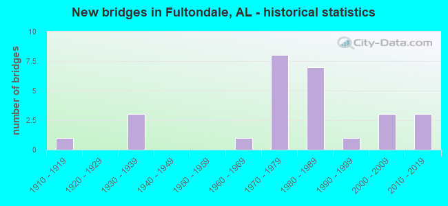
- New bridges - historical statistics
- 11910-1919
- 31930-1939
- 11960-1969
- 81970-1979
- 71980-1989
- 11990-1999
- 32000-2009
- 32010-2019
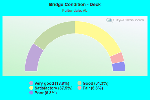
- Bridge Condition - Deck
- 18.8%Very good
- 31.3%Good
- 37.5%Satisfactory
- 6.3%Fair
- 6.3%Poor
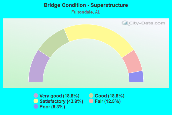
- Bridge Condition - Superstructure
- 18.8%Very good
- 18.8%Good
- 43.8%Satisfactory
- 12.5%Fair
- 6.3%Poor
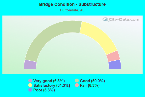
- Bridge Condition - Substructure
- 6.3%Very good
- 50.0%Good
- 31.3%Satisfactory
- 6.3%Fair
- 6.3%Poor
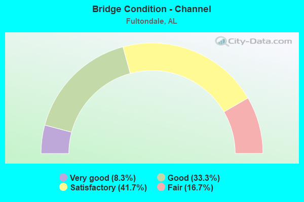
- Bridge Condition - Channel
- 8.3%Very good
- 33.3%Good
- 41.7%Satisfactory
- 16.7%Fair
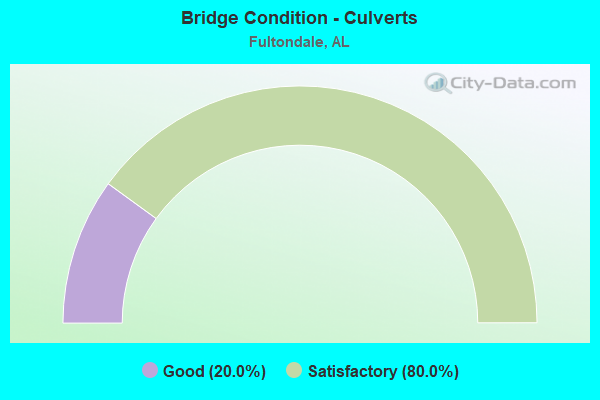
- Bridge Condition - Culverts
- 20.0%Good
- 80.0%Satisfactory
Find on map >> Show street view
Structure Number: 923, Location: OLD US 31 * BLACK CREEK (Lat: 33.583333, Lng: -86.816667), Route carried "on" structure: City street , Year Built: 1931, Status: Closed, Structure Length: 10.36m (33.99ft), Average Daily Traffic: 1,250 (year 2020), Truck Traffic: 1%, Average Future Daily Traffic: 2,000 (year 2040), Design Load: H 15, Features Intersected: RAILROAD * BLACK CK, Facility Carried by Structure: CITY STREET
Minimum Vertical Clearance: 30+ m (98+ ft), Kilometerpoint: 3.100, Lanes on structure: 2, Owner: City or Municipal Highway Agency, Approaching Roadway Width: 6.7m (22.0ft), Material/Design: Concrete, Design/Construction: Tee Beam, Number Of Spans In Main Unit: 10, Length of Maximum Span: 10.4m (34.1ft), Curb-To-Curb Width: 6.0m (19.7ft), Out-to-Out Width: 7.2m (23.6ft)
Condition: Deck: Satisfactory, Superstructure: Fair, Substructure: Poor, Channel: Fair, Waterway Adequacy: Superior to present desirable criteria, Approach Roadway Alignment: Equal to present minimum criteria, Bridge Posting: Required (Relationship of Operating Rating to Maximum Legal Load: > 39.9% below), Length Of Structure Improvement: 11.28m (37.01ft), Designated Inspection Frequency: Every 24 months, Other Special Inspection Frequency: Every 12 months, Inspection Date: August 2020, Other Special Inspection Date: August 2021, Bridge Improvement Cost: $1,779,000, Roadway Improvement Cost: $178,000, Total Project Cost: $1,957,000 ( Estimate for 2022), Deck Structure Type: Concrete Cast-file-Place, Wearing Surface/Protective System: Wearing Surface: Bituminous
Find on map >> Show street view
Structure Number: 1351, Location: .75 MILE N. OF FULTONDALE (Lat: 33.622108, Lng: -86.803239), Route carried "on" structure: City street 223, Year Built: 1935, Status: Posted for load, Structure Length: 0.69m (2.26ft), Average Daily Traffic: 1,400 (year 2020), Truck Traffic: 5%, Average Future Daily Traffic: 1,960 (year 2040), Features Intersected: BLACK CREEK TRIBUTARY, Facility Carried by Structure: COUNTY ROAD
Minimum Vertical Clearance: 30+ m (98+ ft), Kilometerpoint: 0.010, Lanes on structure: 2, Owner: City or Municipal Highway Agency, Approaching Roadway Width: 5.5m (18.0ft), Material/Design: Concrete, Design/Construction: Slab, Number Of Spans In Main Unit: 1, Length of Maximum Span: 6.9m (22.6ft), Curb-To-Curb Width: 6.7m (22.0ft), Out-to-Out Width: 7.3m (24.0ft)
Condition: Deck: Poor, Superstructure: Poor, Substructure: Good, Channel: Fair, Operating Rating: 18.1 metric tons, Method Used To Determine Operating Rating: Field evaluation and documented engineering judgment, Inventory Rating: 13.6 metric tons, Method Used To Determine Inventory Rating: Field evaluation and documented engineering judgment, Structural Evaluation: Meets minimum limits, Deck Geometry: High priority of corrective action, Waterway Adequacy: Better than present minimum criteria, Approach Roadway Alignment: Better than present minimum criteria, Bridge Posting: Required (Relationship of Operating Rating to Maximum Legal Load: > 39.9% below), Length Of Structure Improvement: 1.32m (4.33ft), Designated Inspection Frequency: Every 24 months, Other Special Inspection Frequency: Every 12 months, Inspection Date: August 2020, Other Special Inspection Date: August 2021, Bridge Improvement Cost: $218,000, Roadway Improvement Cost: $22,000, Total Project Cost: $240,000 ( Estimate for 2022), Deck Structure Type: Concrete Cast-file-Place
Find on map >> Show street view
Structure Number: 1101, Location: FULTONDALE (Lat: 33.621667, Lng: -86.803333), Route carried "on" structure: City street , Year Built: 1973, Status: Open, Structure Length: 1.61m (5.28ft), Average Daily Traffic: 1,886 (year 2020), Truck Traffic: 5%, Average Future Daily Traffic: 4,000 (year 2040), Design Load: H 20, Features Intersected: BLACK CREEK, Facility Carried by Structure: STOUTS ROAD
Minimum Vertical Clearance: 30+ m (98+ ft), Kilometerpoint: 0.010, Lanes on structure: 2, Owner: City or Municipal Highway Agency, Approaching Roadway Width: 6.1m (20.0ft), Material/Design: Steel, Design/Construction: Stringer/Multi-beam, Number Of Spans In Main Unit: 1, Length of Maximum Span: 16.1m (52.8ft), Curb-To-Curb Width: 8.5m (27.9ft), Out-to-Out Width: 9.4m (30.8ft)
Condition: Deck: Good, Superstructure: Good, Substructure: Good, Channel: Good, Operating Rating: 38.7 metric tons, Method Used To Determine Operating Rating: Load Factor (LF), Inventory Rating: 23.2 metric tons, Method Used To Determine Inventory Rating: Load Factor (LF), Structural Evaluation: Equal to present minimum criteria, Deck Geometry: Somewhat better than minimum adequacy, Waterway Adequacy: Better than present minimum criteria, Approach Roadway Alignment: Equal to present desirable criteria, Length Of Structure Improvement: 2.30m (7.55ft), Designated Inspection Frequency: Every 24 months, Inspection Date: August 2020, Bridge Improvement Cost: $472,000, Roadway Improvement Cost: $47,000, Total Project Cost: $519,000 ( Estimate for 2022), Deck Structure Type: Concrete Cast-file-Place
Find on map >> Show street view
Structure Number: 11348, Location: FULTONDALE INTERCHANGE (Lat: 33.584236, Lng: -86.805606), Route carried "on" structure: Ramp Interstate 65, Year Built: 1975, Status: Open, Structure Length: 10.98m (36.02ft), Average Daily Traffic: 7,575 (year 2020), Truck Traffic: 17%, Average Future Daily Traffic: 9,597 (year 2040), Design Load: HS 20, Features Intersected: I - 65, Facility Carried by Structure: RAMP B
Minimum Vertical Clearance: 30+ m (98+ ft), Kilometerpoint: 427.154, Lanes on structure: 2, Lanes under structure: 4, Owner: State Highway Agency, Approaching Roadway Width: 13.4m (44.0ft), Skew: 3 degrees, Material/Design: Steel continuous, Design/Construction: Stringer/Multi-beam, Number Of Spans In Main Unit: 4, Length of Maximum Span: 31.7m (104.0ft), Curb-To-Curb Width: 11.9m (39.0ft), Out-to-Out Width: 12.4m (40.7ft)
Condition: Deck: Satisfactory, Superstructure: Satisfactory, Substructure: Satisfactory, Operating Rating: 63.1 metric tons, Method Used To Determine Operating Rating: Load Factor (LF), Inventory Rating: 37.8 metric tons, Method Used To Determine Inventory Rating: Load Factor (LF), Structural Evaluation: Equal to present minimum criteria, Deck Geometry: Superior to present desirable criteria, Underclear: Superior to present desirable criteria, Approach Roadway Alignment: Equal to present desirable criteria, Length Of Structure Improvement: 11.87m (38.94ft), Designated Inspection Frequency: Every 24 months, Inspection Date: June 2020, Bridge Improvement Cost: $3,255,000, Roadway Improvement Cost: $326,000, Total Project Cost: $3,581,000 ( Estimate for 2022), Deck Structure Type: Concrete Cast-file-Place
Find on map >> Show street view
Structure Number: 1135, Location: FULTONDALE INTERCHANGE (Lat: 33.585200, Lng: -86.807400), Route carried "on" structure: Ramp Interstate 65, Year Built: 1975, Status: Open, Structure Length: 12.86m (42.19ft), Average Daily Traffic: 7,575 (year 2020), Truck Traffic: 17%, Average Future Daily Traffic: 9,597 (year 2040), Design Load: HS 20, Features Intersected: I - 65, Facility Carried by Structure: RAMP C
Minimum Vertical Clearance: 30+ m (98+ ft), Kilometerpoint: 427.041, Lanes on structure: 1, Lanes under structure: 12, Owner: State Highway Agency, Approaching Roadway Width: 13.4m (44.0ft), Skew: 3 degrees, Material/Design: Steel continuous, Design/Construction: Stringer/Multi-beam, Number Of Spans In Main Unit: 4, Length of Maximum Span: 35.1m (115.2ft), Curb-To-Curb Width: 7.5m (24.6ft), Out-to-Out Width: 8.0m (26.2ft)
Condition: Deck: Satisfactory, Superstructure: Satisfactory, Substructure: Satisfactory, Operating Rating: 60.4 metric tons, Method Used To Determine Operating Rating: Load Factor (LF), Inventory Rating: 36.2 metric tons, Method Used To Determine Inventory Rating: Load Factor (LF), Structural Evaluation: Equal to present minimum criteria, Deck Geometry: Better than present minimum criteria, Underclear: Equal to present minimum criteria, Approach Roadway Alignment: Equal to present minimum criteria, Length Of Structure Improvement: 13.69m (44.91ft), Designated Inspection Frequency: Every 24 months, Inspection Date: June 2020, Bridge Improvement Cost: $2,441,000, Roadway Improvement Cost: $244,000, Total Project Cost: $2,685,000 ( Estimate for 2022), Deck Structure Type: Concrete Cast-file-Place
Find on map >> Show street view
Structure Number: 11596, Location: US 31 * 5 MILE CK (Lat: 33.590000, Lng: -86.803611), Route carried "on" structure: US 31, Year Built: 1976, Status: Open, Structure Length: 6.89m (22.60ft), Average Daily Traffic: 21,130 (year 2021), Truck Traffic: 3%, Average Future Daily Traffic: 27,143 (year 2041), Design Load: HS 20, Features Intersected: 5 MILE CREEK
Minimum Vertical Clearance: 30+ m (98+ ft), Kilometerpoint: 450.941, Lanes on structure: 5, Owner: State Highway Agency, Approaching Roadway Width: 30.5m (100.1ft), Material/Design: Steel, Design/Construction: Stringer/Multi-beam, Number Of Spans In Main Unit: 3, Length of Maximum Span: 24.7m (81.0ft), Curb-To-Curb Width: 30.7m (100.7ft), Out-to-Out Width: 31.6m (103.7ft)
Condition: Deck: Satisfactory, Superstructure: Satisfactory, Substructure: Good, Channel: Good, Operating Rating: 61.6 metric tons, Method Used To Determine Operating Rating: Load Factor (LF), Inventory Rating: 36.8 metric tons, Method Used To Determine Inventory Rating: Load Factor (LF), Structural Evaluation: Equal to present minimum criteria, Deck Geometry: Superior to present desirable criteria, Waterway Adequacy: Equal to present desirable criteria, Approach Roadway Alignment: Equal to present desirable criteria, Length Of Structure Improvement: 7.92m (25.98ft), Designated Inspection Frequency: Every 24 months, Inspection Date: May 2021, Bridge Improvement Cost: $5,596,000, Roadway Improvement Cost: $560,000, Total Project Cost: $6,156,000 ( Estimate for 2022), Deck Structure Type: Concrete Cast-file-Place
Find on map >> Show street view
Structure Number: 12221, Location: 0.4 MI E SHADY GROVE RD (Lat: 33.612033, Lng: -86.842511), Route carried "on" structure: County highway 120, Year Built: 1979, Status: Closed, Structure Length: 2.49m (8.17ft), Average Daily Traffic: 1,500 (year 2021), Truck Traffic: 9%, Average Future Daily Traffic: 1,680 (year 2041), Features Intersected: BLACK CREEK, Facility Carried by Structure: WALKERS CHAPEL RD
Minimum Vertical Clearance: 30+ m (98+ ft), Kilometerpoint: 0.000, Lanes on structure: 2, Owner: County Highway Agency, Approaching Roadway Width: 5.1m (16.7ft), Material/Design: Steel continuous, Design/Construction: Stringer/Multi-beam, Number Of Spans In Main Unit: 2, Length of Maximum Span: 12.0m (39.4ft), Curb-To-Curb Width: 5.6m (18.4ft), Out-to-Out Width: 5.6m (18.4ft)
Condition: Deck: Fair, Superstructure: Fair, Substructure: Fair, Channel: Satisfactory, Operating Rating: 43.7 metric tons, Method Used To Determine Operating Rating: Load Factor (LF), Inventory Rating: 26.2 metric tons, Method Used To Determine Inventory Rating: Load Factor (LF), Structural Evaluation: Somewhat better than minimum adequacy, Waterway Adequacy: Equal to present minimum criteria, Approach Roadway Alignment: Somewhat better than minimum adequacy, Length Of Structure Improvement: 3.37m (11.06ft), Designated Inspection Frequency: Every 24 months, Other Special Inspection Frequency: Every 12 months, Inspection Date: May 2021, Other Special Inspection Date: May 2021, Bridge Improvement Cost: $416,000, Roadway Improvement Cost: $42,000, Total Project Cost: $458,000 ( Estimate for 2022), Deck Structure Type: Open Grating
Find on map >> Show street view
Structure Number: 12921, Location: .5 MI. NO. WALKERS CHAPEL (Lat: 33.616508, Lng: -86.813656), Route carried "on" structure: Interstate 65, Year Built: 1983, Status: Open, Structure Length: 5.70m (18.70ft), Average Daily Traffic: 33,375 (year 2020), Truck Traffic: 19%, Average Future Daily Traffic: 42,283 (year 2040), Design Load: HS 20, Features Intersected: CITY OF FULTONDALE
Minimum Vertical Clearance: 30+ m (98+ ft), Kilometerpoint: 430.454, Lanes on structure: 3, Base Highway Network: Yes, Owner: State Highway Agency, Approaching Roadway Width: 17.1m (56.1ft), Skew: 3 degrees, Material/Design: Prestressed concrete continuous, Design/Construction: Stringer/Multi-beam, Number Of Spans In Main Unit: 3, Length of Maximum Span: 21.3m (69.9ft), Curb-To-Curb Width: 17.1m (56.1ft), Out-to-Out Width: 17.9m (58.7ft)
Condition: Deck: Good, Superstructure: Satisfactory, Substructure: Good, Operating Rating: 55.3 metric tons, Method Used To Determine Operating Rating: Load Factor (LF), Inventory Rating: 29.5 metric tons, Method Used To Determine Inventory Rating: Load Factor (LF), Structural Evaluation: Equal to present minimum criteria, Deck Geometry: Equal to present minimum criteria, Underclear: Superior to present desirable criteria, Approach Roadway Alignment: Equal to present desirable criteria, Length Of Structure Improvement: 6.74m (22.11ft), Designated Inspection Frequency: Every 24 months, Inspection Date: May 2020, Bridge Improvement Cost: $2,679,000, Roadway Improvement Cost: $268,000, Total Project Cost: $2,947,000 ( Estimate for 2022), Deck Structure Type: Concrete Cast-file-Place
Find on map >> Show street view
Structure Number: 12922, Location: .5 MI. NO. WALKERS CHAPEL (Lat: 33.616478, Lng: -86.813350), Route carried "on" structure: Interstate 65, Year Built: 1983, Status: Open, Structure Length: 5.70m (18.70ft), Average Daily Traffic: 33,375 (year 2020), Truck Traffic: 19%, Average Future Daily Traffic: 42,283 (year 2040), Design Load: HS 20, Features Intersected: CITY OF FULTONDALE
Minimum Vertical Clearance: 30+ m (98+ ft), Kilometerpoint: 430.454, Lanes on structure: 3, Base Highway Network: Yes, Owner: State Highway Agency, Approaching Roadway Width: 17.1m (56.1ft), Skew: 3 degrees, Material/Design: Prestressed concrete continuous, Design/Construction: Stringer/Multi-beam, Number Of Spans In Main Unit: 3, Length of Maximum Span: 21.3m (69.9ft), Curb-To-Curb Width: 17.1m (56.1ft), Out-to-Out Width: 17.9m (58.7ft)
Condition: Deck: Good, Superstructure: Satisfactory, Substructure: Good, Operating Rating: 55.6 metric tons, Method Used To Determine Operating Rating: Load Factor (LF), Inventory Rating: 29.7 metric tons, Method Used To Determine Inventory Rating: Load Factor (LF), Structural Evaluation: Equal to present minimum criteria, Deck Geometry: Equal to present minimum criteria, Underclear: Superior to present desirable criteria, Approach Roadway Alignment: Equal to present desirable criteria, Length Of Structure Improvement: 6.74m (22.11ft), Designated Inspection Frequency: Every 24 months, Inspection Date: May 2020, Bridge Improvement Cost: $2,679,000, Roadway Improvement Cost: $268,000, Total Project Cost: $2,947,000 ( Estimate for 2022), Deck Structure Type: Concrete Cast-file-Place
Find on map >> Show street view
Structure Number: 13176, Location: I65 * WALKER CHAPEL RD (Lat: 33.608178, Lng: -86.809119), Route carried "on" structure: County highway , Year Built: 1984, Status: Open, Structure Length: 11.43m (37.50ft), Average Daily Traffic: 5,500 (year 2000), Truck Traffic: 1%, Average Future Daily Traffic: 7,500 (year 2040), Design Load: HS 20, Features Intersected: I65, Facility Carried by Structure: WALKER CHAPEL RD
Minimum Vertical Clearance: 30+ m (98+ ft), Kilometerpoint: 0.010, Lanes on structure: 6, Lanes under structure: 7, Owner: State Highway Agency, Approaching Roadway Width: 24.4m (80.1ft), Skew: 20 degrees, Material/Design: Steel, Design/Construction: Stringer/Multi-beam, Number Of Spans In Main Unit: 3, Number Of Approach Spans: 2, Length of Maximum Span: 31.1m (102.0ft), Curb or Sidewalk Widths: Left: 0.0m, Right: 1.7m (5.6ft), Curb-To-Curb Width: 23.4m (76.8ft), Out-to-Out Width: 28.2m (92.5ft)
Condition: Deck: Satisfactory, Superstructure: Satisfactory, Substructure: Satisfactory, Operating Rating: 66.0 metric tons, Method Used To Determine Operating Rating: Load Factor (LF), Inventory Rating: 39.6 metric tons, Method Used To Determine Inventory Rating: Load Factor (LF), Structural Evaluation: Equal to present minimum criteria, Deck Geometry: Somewhat better than minimum adequacy, Underclear: Better than present minimum criteria, Approach Roadway Alignment: Equal to present desirable criteria, Length Of Structure Improvement: 12.30m (40.35ft), Designated Inspection Frequency: Every 24 months, Inspection Date: June 2020, Bridge Improvement Cost: $7,762,000, Roadway Improvement Cost: $776,000, Total Project Cost: $8,538,000 ( Estimate for 2022), Deck Structure Type: Concrete Cast-file-Place
Find on map >> Show street view
Structure Number: 13177, Location: .3 MI. NO.WALKERS CHAPEL (Lat: 33.615803, Lng: -86.813067), Route carried "on" structure: Interstate 65, Year Built: 1984, Status: Open, Structure Length: 1.46m (4.79ft), Average Daily Traffic: 66,750 (year 2020), Truck Traffic: 19%, Average Future Daily Traffic: 84,567 (year 2040), Design Load: HS 20, Features Intersected: BLACK CK
Minimum Vertical Clearance: 30+ m (98+ ft), Kilometerpoint: 430.376, Lanes on structure: 6, Base Highway Network: Yes, Owner: State Highway Agency, Approaching Roadway Width: 18.3m (60.0ft), Skew: 4 degrees, Material/Design: Concrete, Design/Construction: Culvert, Number Of Spans In Main Unit: 3, Length of Maximum Span: 3.0m (9.8ft)
Condition: Channel: Satisfactory, Culverts: Satisfactory, Operating Rating: 88.9 metric tons, Method Used To Determine Operating Rating: Load Factor (LF), Inventory Rating: 88.9 metric tons, Method Used To Determine Inventory Rating: Load Factor (LF), Structural Evaluation: Equal to present minimum criteria, Waterway Adequacy: Better than present minimum criteria, Approach Roadway Alignment: Equal to present desirable criteria, Length Of Structure Improvement: 2.14m (7.02ft), Designated Inspection Frequency: Every 24 months, Inspection Date: September 2020, Bridge Improvement Cost: $9,688,000, Roadway Improvement Cost: $969,000, Total Project Cost: $10,657,000 ( Estimate for 2022), Wearing Surface/Protective System: Wearing Surface: Bituminous
Find on map >> Show street view
Structure Number: 13178, Location: I65 * RIDGE BROOK ROAD (Lat: 33.622097, Lng: -86.817128), Route carried "on" structure: County highway , Year Built: 1984, Status: Open, Structure Length: 10.49m (34.42ft), Average Daily Traffic: 700 (year 2002), Truck Traffic: 1%, Average Future Daily Traffic: 800 (year 2040), Design Load: HS 20, Features Intersected: I 65, Facility Carried by Structure: RIDGE BROOK ROAD
Minimum Vertical Clearance: 30+ m (98+ ft), Kilometerpoint: 0.010, Lanes on structure: 2, Lanes under structure: 6, Owner: State Highway Agency, Approaching Roadway Width: 8.5m (27.9ft), Skew: 3 degrees, Material/Design: Steel continuous, Design/Construction: Stringer/Multi-beam, Number Of Spans In Main Unit: 4, Length of Maximum Span: 31.1m (102.0ft), Curb or Sidewalk Widths: Left: 0.0m, Right: 1.5m (4.9ft), Curb-To-Curb Width: 8.5m (27.9ft), Out-to-Out Width: 11.0m (36.1ft)
Condition: Deck: Good, Superstructure: Good, Substructure: Good, Operating Rating: 62.8 metric tons, Method Used To Determine Operating Rating: Load Factor (LF), Inventory Rating: 37.6 metric tons, Method Used To Determine Inventory Rating: Load Factor (LF), Structural Evaluation: Better than present minimum criteria, Deck Geometry: Somewhat better than minimum adequacy, Underclear: Equal to present minimum criteria, Approach Roadway Alignment: Better than present minimum criteria, Length Of Structure Improvement: 11.40m (37.40ft), Designated Inspection Frequency: Every 24 months, Inspection Date: October 2020, Bridge Improvement Cost: $2,814,000, Roadway Improvement Cost: $281,000, Total Project Cost: $3,095,000 ( Estimate for 2022), Deck Structure Type: Concrete Cast-file-Place
Find on map >> Show street view
Structure Number: 16691, Location: 100' S YARBROUGH RD (Lat: 33.619350, Lng: -86.789317), Route carried "on" structure: County highway 224, Year Built: 1979, Status: Open, Structure Length: 0.79m (2.59ft), Average Daily Traffic: 17,505 (year 2019), Truck Traffic: 22%, Average Future Daily Traffic: 24,500 (year 2039), Design Load: HS 20, Features Intersected: BLACK CREEK TRIBUTARY, Facility Carried by Structure: CARSON ROAD
Minimum Vertical Clearance: 30+ m (98+ ft), Kilometerpoint: 0.000, Lanes on structure: 2, Owner: County Highway Agency, Approaching Roadway Width: 9.6m (31.5ft), Skew: 1 degrees, Material/Design: Concrete, Design/Construction: Culvert, Number Of Spans In Main Unit: 2, Length of Maximum Span: 3.6m (11.8ft)
Condition: Channel: Satisfactory, Culverts: Good, Operating Rating: 87.5 metric tons, Method Used To Determine Operating Rating: Load Factor (LF), Inventory Rating: 52.4 metric tons, Method Used To Determine Inventory Rating: Load Factor (LF), Structural Evaluation: Better than present minimum criteria, Waterway Adequacy: Equal to present minimum criteria, Approach Roadway Alignment: Equal to present desirable criteria, Length Of Structure Improvement: 1.44m (4.72ft), Designated Inspection Frequency: Every 24 months, Inspection Date: January 2021, Bridge Improvement Cost: $492,000, Roadway Improvement Cost: $49,000, Total Project Cost: $541,000 ( Estimate for 2022)
Find on map >> Show street view
Structure Number: 16692, Location: 0.5 MI N US 31 (Lat: 33.617267, Lng: -86.791267), Route carried "on" structure: County highway 224, Year Built: 1930, Status: Open, Structure Length: 0.98m (3.22ft), Average Daily Traffic: 17,525 (year 2021), Truck Traffic: 22%, Average Future Daily Traffic: 24,500 (year 2041), Design Load: HS 20, Features Intersected: BLACK CREEK, Facility Carried by Structure: CARSON ROAD
Minimum Vertical Clearance: 30+ m (98+ ft), Kilometerpoint: 0.010, Lanes on structure: 2, Owner: County Highway Agency, Approaching Roadway Width: 7.2m (23.6ft), Material/Design: Concrete continuous, Design/Construction: Slab, Number Of Spans In Main Unit: 2, Length of Maximum Span: 4.9m (16.1ft), Curb or Sidewalk Widths: Left: 0.1m (0.3ft), Right: 0.3m (1.0ft), Curb-To-Curb Width: 13.0m (42.7ft), Out-to-Out Width: 14.0m (45.9ft)
Condition: Deck: Satisfactory, Superstructure: Satisfactory, Substructure: Satisfactory, Channel: Satisfactory, Operating Rating: 32.7 metric tons, Method Used To Determine Operating Rating: Field evaluation and documented engineering judgment, Inventory Rating: 23.6 metric tons, Method Used To Determine Inventory Rating: Field evaluation and documented engineering judgment, Structural Evaluation: Somewhat better than minimum adequacy, Deck Geometry: Somewhat better than minimum adequacy, Waterway Adequacy: Better than present minimum criteria, Approach Roadway Alignment: Better than present minimum criteria, Length Of Structure Improvement: 1.65m (5.41ft), Designated Inspection Frequency: Every 24 months, Inspection Date: January 2021, Bridge Improvement Cost: $510,000, Roadway Improvement Cost: $51,000, Total Project Cost: $561,000 ( Estimate for 2022), Deck Structure Type: Concrete Cast-file-Place, Wearing Surface/Protective System: Wearing Surface: Bituminous
Find on map >> Show street view
Structure Number: 16694, Location: 1 MI NE PINEHILL RD (Lat: 33.640131, Lng: -86.768456), Route carried "on" structure: County highway , Year Built: 1965, Status: Open, Structure Length: 0.63m (2.07ft), Average Daily Traffic: 6,825 (year 2019), Truck Traffic: 16%, Average Future Daily Traffic: 9,500 (year 2039), Design Load: HS 20, Features Intersected: BLACK CREEK, Facility Carried by Structure: CARSON ROAD
Minimum Vertical Clearance: 30+ m (98+ ft), Kilometerpoint: 0.000, Lanes on structure: 2, Owner: County Highway Agency, Approaching Roadway Width: 8.2m (26.9ft), Material/Design: Concrete continuous, Design/Construction: Culvert, Number Of Spans In Main Unit: 2, Length of Maximum Span: 3.0m (9.8ft)
Condition: Channel: Satisfactory, Culverts: Satisfactory, Operating Rating: 88.9 metric tons, Method Used To Determine Operating Rating: Load Factor (LF), Inventory Rating: 88.9 metric tons, Method Used To Determine Inventory Rating: Load Factor (LF), Structural Evaluation: Equal to present minimum criteria, Waterway Adequacy: Better than present minimum criteria, Approach Roadway Alignment: Equal to present desirable criteria, Length Of Structure Improvement: 1.24m (4.07ft), Designated Inspection Frequency: Every 24 months, Inspection Date: January 2021, Bridge Improvement Cost: $875,000, Roadway Improvement Cost: $88,000, Total Project Cost: $963,000 ( Estimate for 2022)
Find on map >> Show street view
Structure Number: 17061, Location: 0.5MI S PINE HILL RD (Lat: 33.624667, Lng: -86.784267), Route carried "on" structure: County highway , Year Built: 1997, Status: Open, Structure Length: 4.18m (13.71ft), Average Daily Traffic: 9,625 (year 2021), Truck Traffic: 15%, Average Future Daily Traffic: 11,570 (year 2041), Design Load: HS 20, Features Intersected: CSX RAILROAD, Facility Carried by Structure: CARSON ROAD
Minimum Vertical Clearance: 30+ m (98+ ft), Kilometerpoint: 0.010, Lanes on structure: 2, Owner: County Highway Agency, Approaching Roadway Width: 12.2m (40.0ft), Skew: 5 degrees, Material/Design: Prestressed concrete, Design/Construction: Stringer/Multi-beam, Number Of Spans In Main Unit: 1, Length of Maximum Span: 41.1m (134.8ft), Curb-To-Curb Width: 12.2m (40.0ft), Out-to-Out Width: 13.0m (42.7ft)
Condition: Deck: Very good, Superstructure: Very good, Substructure: Good, Operating Rating: 62.8 metric tons, Method Used To Determine Operating Rating: Load Factor (LF), Inventory Rating: 29.5 metric tons, Method Used To Determine Inventory Rating: Load Factor (LF), Structural Evaluation: Better than present minimum criteria, Deck Geometry: Somewhat better than minimum adequacy, Underclear: Superior to present desirable criteria, Approach Roadway Alignment: Equal to present desirable criteria, Length Of Structure Improvement: 5.14m (16.86ft), Designated Inspection Frequency: Every 24 months, Inspection Date: July 2021, Bridge Improvement Cost: $1,481,000, Roadway Improvement Cost: $148,000, Total Project Cost: $1,629,000 ( Estimate for 2022), Deck Structure Type: Concrete Cast-file-Place
Find on map >> Show street view
Structure Number: 17841, Location: LOWER COALBURG (Lat: 33.587100, Lng: -86.838600), Route carried "on" structure: Interstate 22, Year Built: 2006, Status: Open, Structure Length: 0.82m (2.69ft), Average Daily Traffic: 11,910 (year 2021), Truck Traffic: 33%, Average Future Daily Traffic: 16,136 (year 2041), Design Load: HS 20, Features Intersected: UNNAMED CREEK
Minimum Vertical Clearance: 30.18m (99.02ft), Kilometerpoint: 0.002, Lanes on structure: 6, Base Highway Network: Yes, Owner: State Highway Agency, Approaching Roadway Width: 26.8m (87.9ft), Skew: 1 degrees, Material/Design: Concrete, Design/Construction: Culvert, Number Of Spans In Main Unit: 3, Length of Maximum Span: 2.4m (7.9ft)
Condition: Channel: Good, Culverts: Satisfactory, Operating Rating: 88.9 metric tons, Method Used To Determine Operating Rating: Load Factor (LF), Inventory Rating: 88.9 metric tons, Method Used To Determine Inventory Rating: Load Factor (LF), Structural Evaluation: Equal to present minimum criteria, Waterway Adequacy: Superior to present desirable criteria, Approach Roadway Alignment: Superior to present desirable criteria, Length Of Structure Improvement: 1.47m (4.82ft), Designated Inspection Frequency: Every 24 months, Inspection Date: May 2021, Bridge Improvement Cost: $7,655,000, Roadway Improvement Cost: $766,000, Total Project Cost: $8,421,000 ( Estimate for 2022)
Find on map >> Show street view
Structure Number: 17842, Location: NORTH OF COALBURG RD (Lat: 33.588400, Lng: -86.847100), Route carried "on" structure: Interstate 22, Year Built: 2007, Status: Open, Structure Length: 0.79m (2.59ft), Average Daily Traffic: 11,910 (year 2020), Truck Traffic: 33%, Average Future Daily Traffic: 16,136 (year 2040), Design Load: HS 20, Features Intersected: UNNAMED CREEK
Minimum Vertical Clearance: 30.18m (99.02ft), Kilometerpoint: 0.100, Lanes on structure: 6, Base Highway Network: Yes, Owner: State Highway Agency, Approaching Roadway Width: 17.1m (56.1ft), Skew: 1 degrees, Material/Design: Concrete, Design/Construction: Culvert, Number Of Spans In Main Unit: 3, Length of Maximum Span: 2.4m (7.9ft), Curb-To-Curb Width: 44.5m (146.0ft), Out-to-Out Width: 304.5m (999.0ft)
Condition: Channel: Good, Culverts: Satisfactory, Operating Rating: 88.9 metric tons, Method Used To Determine Operating Rating: Load Factor (LF), Inventory Rating: 88.9 metric tons, Method Used To Determine Inventory Rating: Load Factor (LF), Structural Evaluation: Equal to present minimum criteria, Deck Geometry: Superior to present desirable criteria, Waterway Adequacy: Superior to present desirable criteria, Approach Roadway Alignment: Superior to present desirable criteria, Length Of Structure Improvement: 1.45m (4.76ft), Designated Inspection Frequency: Every 24 months, Inspection Date: July 2020, Bridge Improvement Cost: $7,907,000, Roadway Improvement Cost: $791,000, Total Project Cost: $8,698,000 ( Estimate for 2022)
Find on map >> Show street view
Structure Number: 18224, Location: 0.75 MI E US 31 (Lat: 33.615817, Lng: -86.784967), Route carried "on" structure: County highway 124, Year Built: 2004, Status: Open, Structure Length: 4.11m (13.48ft), Average Daily Traffic: 8,700 (year 2020), Truck Traffic: 16%, Average Future Daily Traffic: 10,100 (year 2040), Design Load: HS 20, Features Intersected: CSX RAILROAD, Facility Carried by Structure: BLACK CREEK ROAD
Minimum Vertical Clearance: 30+ m (98+ ft), Kilometerpoint: 0.000, Lanes on structure: 2, Owner: County Highway Agency, Approaching Roadway Width: 12.2m (40.0ft), Skew: 3 degrees, Material/Design: Prestressed concrete, Design/Construction: Stringer/Multi-beam, Number Of Spans In Main Unit: 1, Length of Maximum Span: 39.2m (128.6ft), Curb-To-Curb Width: 12.2m (40.0ft), Out-to-Out Width: 13.0m (42.7ft)
Condition: Deck: Good, Superstructure: Good, Substructure: Very good, Operating Rating: 73.1 metric tons, Method Used To Determine Operating Rating: Load Factor (LF), Inventory Rating: 34.6 metric tons, Method Used To Determine Inventory Rating: Load Factor (LF), Structural Evaluation: Better than present minimum criteria, Deck Geometry: Somewhat better than minimum adequacy, Underclear: Equal to present minimum criteria, Approach Roadway Alignment: Equal to present desirable criteria, Length Of Structure Improvement: 5.08m (16.67ft), Designated Inspection Frequency: Every 24 months, Inspection Date: April 2020, Bridge Improvement Cost: $1,463,000, Roadway Improvement Cost: $146,000, Total Project Cost: $1,609,000 ( Estimate for 2022), Deck Structure Type: Concrete Cast-file-Place
Find on map >> Show street view
Structure Number: 19045, Location: FULTONDALE (Lat: 33.590400, Lng: -86.805400), Route carried "on" structure: Interstate 65, Year Built: 2015, Status: Open, Structure Length: 17.64m (57.87ft), Design Load: HS 20, Features Intersected: 5 MILE CK * ELLARD RD
Minimum Vertical Clearance: 30+ m (98+ ft), Kilometerpoint: 427.876, Lanes on structure: 6, Lanes under structure: 2, Base Highway Network: Yes, Owner: State Highway Agency, Approaching Roadway Width: 28.7m (94.2ft), Material/Design: Steel continuous, Design/Construction: Stringer/Multi-beam, Number Of Spans In Main Unit: 6, Length of Maximum Span: 38.1m (125.0ft), Curb-To-Curb Width: 28.7m (94.2ft), Out-to-Out Width: 29.5m (96.8ft)
Condition: Deck: Very good, Superstructure: Very good, Substructure: Good, Channel: Very good, Operating Rating: 69.4 metric tons, Method Used To Determine Operating Rating: Load Factor (LF), Inventory Rating: 41.5 metric tons, Method Used To Determine Inventory Rating: Load Factor (LF), Structural Evaluation: Better than present minimum criteria, Deck Geometry: Better than present minimum criteria, Underclear: Superior to present desirable criteria, Waterway Adequacy: Superior to present desirable criteria, Approach Roadway Alignment: Equal to present desirable criteria, Length Of Structure Improvement: 18.34m (60.17ft), Designated Inspection Frequency: Every 24 months, Inspection Date: January 2022, Bridge Improvement Cost: $12,073,000, Roadway Improvement Cost: $1,207,000, Total Project Cost: $13,280,000 ( Estimate for 2022), Deck Structure Type: Concrete Cast-file-Place
Find on map >> Show street view
Structure Number: 19048, Location: NO. I-22/I-65 INT. (Lat: 33.587303, Lng: -86.804778), Route carried "on" structure: Ramp Interstate 65, Year Built: 2016, Status: Open, Structure Length: 16.09m (52.79ft), Average Daily Traffic: 500 (year 2020), Truck Traffic: 5%, Average Future Daily Traffic: 750 (year 2040), Design Load: HS 20, Features Intersected: AL - 3 (US 31)
Minimum Vertical Clearance: 30+ m (98+ ft), Kilometerpoint: 426.734, Lanes on structure: 2, Lanes under structure: 4, Base Highway Network: Yes, Owner: State Highway Agency, Approaching Roadway Width: 12.2m (40.0ft), Skew: 6 degrees, Material/Design: Steel continuous, Design/Construction: Stringer/Multi-beam, Number Of Spans In Main Unit: 3, Length of Maximum Span: 64.8m (212.6ft), Curb-To-Curb Width: 12.2m (40.0ft), Out-to-Out Width: 13.0m (42.7ft)
Condition: Deck: Very good, Superstructure: Very good, Substructure: Satisfactory, Operating Rating: 54.1 metric tons, Method Used To Determine Operating Rating: Load Factor (LF), Inventory Rating: 32.4 metric tons, Method Used To Determine Inventory Rating: Load Factor (LF), Structural Evaluation: Equal to present minimum criteria, Deck Geometry: Superior to present desirable criteria, Underclear: Equal to present desirable criteria, Approach Roadway Alignment: Equal to present desirable criteria, Length Of Structure Improvement: 16.84m (55.25ft), Designated Inspection Frequency: Every 24 months, Inspection Date: April 2020, Bridge Improvement Cost: $4,850,000, Roadway Improvement Cost: $485,000, Total Project Cost: $5,335,000 ( Estimate for 2022), Deck Structure Type: Concrete Cast-file-Place
Find on map >> Show street view
Structure Number: 106, Location: 100' N YARBROUGH ROAD (Lat: 33.620017, Lng: -86.788933), Route carried "under" structure: County highway 121, Year Built: 1915, Structure Length: 0. m, Average Daily Traffic: 17,380 (year 2006), Truck Traffic: 20%, Features Intersected: CARSON ROAD, Facility Carried by Structure: CSX RAILROAD
Minimum Vertical Clearance: 4.57m (14.99ft), Kilometerpoint: 0.010, Lanes under structure: 2, Material/Design: Steel, Design/Construction: Stringer/Multi-beam, Length of Maximum Span: 14.3m (46.9ft)
Find on map >> Show street view
Structure Number: 11348, Location: FULTONDALE INTERCHANGE (Lat: 33.584236, Lng: -86.805606), Route carried "under" structure: US 31, Year Built: 1975, Structure Length: 0. m, Average Daily Traffic: 11,960 (year 2020), Truck Traffic: 6%, Features Intersected: I - 65, Facility Carried by Structure: RAMP B
Minimum Vertical Clearance: 5.33m (17.49ft), Kilometerpoint: 450.294, Lanes on structure: 2, Lanes under structure: 4, Material/Design: Steel continuous, Design/Construction: Stringer/Multi-beam, Length of Maximum Span: 31.7m (104.0ft)
Find on map >> Show street view
Structure Number: 1135, Location: FULTONDALE INTERCHANGE (Lat: 33.585200, Lng: -86.807400), Route carried "under" structure: Interstate 65, Year Built: 1975, Structure Length: 0. m, Average Daily Traffic: 75,750 (year 2020), Truck Traffic: 17%, Features Intersected: I - 65, Facility Carried by Structure: RAMP C
Minimum Vertical Clearance: 5.49m (18.01ft), Kilometerpoint: 427.041, Lanes on structure: 1, Lanes under structure: 12, Material/Design: Steel continuous, Design/Construction: Stringer/Multi-beam, Length of Maximum Span: 35.1m (115.2ft)
Find on map >> Show street view
Structure Number: 13176, Location: I65 * WALKER CHAPEL RD (Lat: 33.608178, Lng: -86.809119), Route carried "under" structure: Interstate 65, Year Built: 1984, Structure Length: 0. m, Average Daily Traffic: 66,360 (year 2020), Truck Traffic: 18%, Features Intersected: I65, Facility Carried by Structure: WALKER CHAPEL RD
Minimum Vertical Clearance: 5.36m (17.59ft), Kilometerpoint: 429.804, Lanes on structure: 6, Lanes under structure: 7, Material/Design: Steel, Design/Construction: Stringer/Multi-beam, Length of Maximum Span: 31.1m (102.0ft)
Find on map >> Show street view
Structure Number: 13178, Location: I65 * RIDGE BROOK ROAD (Lat: 33.622097, Lng: -86.817128), Route carried "under" structure: Interstate 65, Year Built: 1984, Structure Length: 0. m, Average Daily Traffic: 66,750 (year 2020), Truck Traffic: 19%, Features Intersected: I 65, Facility Carried by Structure: RIDGE BROOK ROAD
Minimum Vertical Clearance: 5.24m (17.19ft), Kilometerpoint: 432.059, Lanes on structure: 2, Lanes under structure: 6, Material/Design: Steel continuous, Design/Construction: Stringer/Multi-beam, Length of Maximum Span: 31.1m (102.0ft)
Find on map >> Show street view
Structure Number: 19048, Location: NO. I-22/I-65 INT. (Lat: 33.587303, Lng: -86.804778), Route carried "under" structure: US 31, Year Built: 2016, Structure Length: 0. m, Average Daily Traffic: 14,900 (year 2020), Truck Traffic: 6%, Features Intersected: AL - 3 (US 31)
Minimum Vertical Clearance: 5.18m (16.99ft), Kilometerpoint: 450.616, Lanes on structure: 2, Lanes under structure: 4, Material/Design: Steel continuous, Design/Construction: Stringer/Multi-beam, Length of Maximum Span: 64.8m (212.6ft)