Bridge Statistics for Frystown, Pennsylvania (PA)
Condition, Traffic, Stress, Structural Evaluation, Project Costs
- National Bridge Inventory (NBI) Statistics
- 22Number of bridges
- 138ft / 41.8mTotal length
- $2,020,000Total costs
- 215,307Total average daily traffic
- 73,173Total average daily truck traffic
- National Bridge Inventory (NBI) Registered Bridges for Frystown
- No street view available for this location
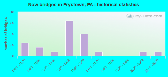
- New bridges - historical statistics
- 31920-1929
- 21930-1939
- 11940-1949
- 81950-1959
- 51960-1969
- 11970-1979
- 12000-2009
- 12010-2019

- Reconstructed bridges - Historical Statistics
- 11950-1959
- 01960-1969
- 11970-1979
- 11980-1989
- 11990-1999
- 22000-2009


- Bridge Condition - Deck
- 13.3%Very good
- 26.7%Good
- 40.0%Satisfactory
- 13.3%Fair
- 6.7%Poor

- Bridge Condition - Superstructure
- 20.0%Very good
- 6.7%Good
- 26.7%Satisfactory
- 46.7%Fair

- Bridge Condition - Substructure
- 6.7%Very good
- 13.3%Good
- 40.0%Satisfactory
- 26.7%Fair
- 13.3%Poor

- Bridge Condition - Channel
- 14.3%Good
- 7.1%Satisfactory
- 50.0%Fair
- 28.6%Poor
Find on map >> Show street view
Structure Number: 4626, Location: NEAR LEBANON COUNTY LINE (Lat: 40.459897, Lng: -76.364678), Route carried "on" structure: Interstate 78, Year Built: 1929, Year Reconstructed: 2001, Status: Open, Structure Length: 1.04m (3.41ft), Average Daily Traffic: 39,871 (year 2022), Truck Traffic: 37%, Average Future Daily Traffic: 45,984 (year 2032), Design Load: HS 25 or greater, Features Intersected: CROSSKILL CREEK
Minimum Vertical Clearance: 30+ m (98+ ft), Kilometerpoint: 1.015, Lanes on structure: 4, Base Highway Network: Yes, Owner: State Highway Agency, Approaching Roadway Width: 28.0m (91.9ft), Skew: 30 degrees, Material/Design: Prestressed concrete, Design/Construction: Box Beam or Girders - Single/Spread, Number Of Spans In Main Unit: 1, Length of Maximum Span: 10.4m (34.1ft), Curb-To-Curb Width: 27.9m (91.5ft), Out-to-Out Width: 29.7m (97.4ft)
Condition: Deck: Good, Superstructure: Very good, Substructure: Satisfactory, Channel: Poor, Operating Rating: 63.5 metric tons, Method Used To Determine Operating Rating: Load Factor (LF), Inventory Rating: 38.1 metric tons, Method Used To Determine Inventory Rating: Load Factor (LF), Structural Evaluation: Equal to present minimum criteria, Deck Geometry: Superior to present desirable criteria, Waterway Adequacy: Superior to present desirable criteria, Approach Roadway Alignment: Equal to present desirable criteria, Length Of Structure Improvement: 1.80m (5.91ft), Designated Inspection Frequency: Every 24 months, Underwater Inspection Frequency: Every 24 months, Inspection Date: January 2020, Underwater Inspection Date: November 2019, Bridge Improvement Cost: $13,000, Roadway Improvement Cost: $37,000, Total Project Cost: $171,000, Deck Structure Type: Concrete Cast-file-Place, Wearing Surface/Protective System: Wearing Surface: Monolithic Concrete, Deck Protection: Epoxy Coated Reinforcing
Find on map >> Show street view
Structure Number: 4627, Location: NEAR PA645 INTERCHANGE (Lat: 40.465525, Lng: -76.343781), Route carried "on" structure: Interstate 78, Year Built: 1972, Status: Open, Structure Length: 1.22m (4.00ft), Average Daily Traffic: 39,871 (year 2022), Truck Traffic: 37%, Average Future Daily Traffic: 45,984 (year 2032), Design Load: HS 20+Mod, Features Intersected: CROSSKILL CREEK
Minimum Vertical Clearance: 30+ m (98+ ft), Kilometerpoint: 2.639, Lanes on structure: 6, Base Highway Network: Yes, Owner: State Highway Agency, Approaching Roadway Width: 46.3m (151.9ft), Skew: 20 degrees, Material/Design: Concrete, Design/Construction: Culvert, Number Of Spans In Main Unit: 2, Length of Maximum Span: 6.1m (20.0ft)
Condition: Channel: Fair, Culverts: Satisfactory, Operating Rating: 97.1 metric tons, Method Used To Determine Operating Rating: Load Factor (LF), Inventory Rating: 58.1 metric tons, Method Used To Determine Inventory Rating: Load Factor (LF), Structural Evaluation: Equal to present minimum criteria, Waterway Adequacy: Equal to present minimum criteria, Approach Roadway Alignment: Equal to present desirable criteria, Length Of Structure Improvement: 1.90m (6.23ft), Designated Inspection Frequency: Every 24 months, Inspection Date: Febuary 2021
Find on map >> Show street view
Structure Number: 4902, Location: CAMP SWATARA ROAD (Lat: 40.443867, Lng: -76.331614), Route carried "on" structure: State highway 645, Year Built: 1949, Status: Open, Structure Length: 6.10m (20.01ft), Average Daily Traffic: 2,379 (year 2022), Truck Traffic: 11%, Average Future Daily Traffic: 2,536 (year 2032), Design Load: HS 20, Features Intersected: LITTLE SWATARA CREEK
Minimum Vertical Clearance: 30+ m (98+ ft), Kilometerpoint: 2.279, Lanes on structure: 2, Owner: State Highway Agency, Approaching Roadway Width: 6.1m (20.0ft), Skew: 3 degrees, Material/Design: Steel, Design/Construction: Stringer/Multi-beam, Number Of Spans In Main Unit: 3, Length of Maximum Span: 19.8m (65.0ft), Curb-To-Curb Width: 7.4m (24.3ft), Out-to-Out Width: 7.9m (25.9ft)
Condition: Deck: Poor, Superstructure: Fair, Substructure: Poor, Channel: Poor, Operating Rating: 65.3 metric tons, Method Used To Determine Operating Rating: Load Factor (LF), Inventory Rating: 39.0 metric tons, Method Used To Determine Inventory Rating: Load Factor (LF), Structural Evaluation: Meets minimum limits, Deck Geometry: High priority of replacement, Waterway Adequacy: Equal to present minimum criteria, Approach Roadway Alignment: Better than present minimum criteria, Length Of Structure Improvement: 7.10m (23.29ft), Designated Inspection Frequency: Every 24 months, Other Special Inspection Frequency: Every 12 months, Inspection Date: May 2021, Other Special Inspection Date: May 2021, Bridge Improvement Cost: $13,000, Roadway Improvement Cost: $39,000, Total Project Cost: $179,000, Deck Structure Type: Open Grating
Find on map >> Show street view
Structure Number: 4903, Location: CAMP SWATARA ROAD (Lat: 40.448042, Lng: -76.334494), Route carried "on" structure: State highway 645, Year Built: 1934, Status: Open, Structure Length: 0.70m (2.30ft), Average Daily Traffic: 2,379 (year 2022), Truck Traffic: 11%, Average Future Daily Traffic: 2,536 (year 2032), Design Load: HS 20, Features Intersected: TRIB LITTLE SWATARA CK
Minimum Vertical Clearance: 30+ m (98+ ft), Kilometerpoint: 3.022, Lanes on structure: 2, Owner: State Highway Agency, Approaching Roadway Width: 6.1m (20.0ft), Material/Design: Concrete, Design/Construction: Tee Beam, Number Of Spans In Main Unit: 1, Length of Maximum Span: 6.4m (21.0ft), Curb-To-Curb Width: 7.0m (23.0ft), Out-to-Out Width: 7.9m (25.9ft)
Condition: Deck: Fair, Superstructure: Fair, Substructure: Fair, Channel: Poor, Operating Rating: 41.7 metric tons, Method Used To Determine Operating Rating: Load Factor (LF), Inventory Rating: 25.4 metric tons, Method Used To Determine Inventory Rating: Load Factor (LF), Structural Evaluation: Somewhat better than minimum adequacy, Deck Geometry: High priority of replacement, Waterway Adequacy: Better than present minimum criteria, Approach Roadway Alignment: Equal to present minimum criteria, Length Of Structure Improvement: 1.30m (4.27ft), Designated Inspection Frequency: Every 24 months, Inspection Date: Febuary 2021, Bridge Improvement Cost: $29,000, Roadway Improvement Cost: $84,000, Total Project Cost: $386,000, Deck Structure Type: Concrete Cast-file-Place, Wearing Surface/Protective System: Wearing Surface: Bituminous
Find on map >> Show street view
Structure Number: 4905, Location: CAMP SWATARA ROAD (Lat: 40.470369, Lng: -76.341333), Route carried "on" structure: State highway 645, Year Built: 1958, Year Reconstructed: 2014, Status: Open, Structure Length: 0.88m (2.89ft), Average Daily Traffic: 1,734 (year 2020), Truck Traffic: 15%, Average Future Daily Traffic: 2,049 (year 2032), Design Load: HL 93, Features Intersected: TRIB.CROSSKILL CREEK
Minimum Vertical Clearance: 30+ m (98+ ft), Kilometerpoint: 5.222, Lanes on structure: 2, Owner: State Highway Agency, Approaching Roadway Width: 8.5m (27.9ft), Skew: 1 degrees, Material/Design: Prestressed concrete, Design/Construction: Box Beam or Girders - Multiple, Number Of Spans In Main Unit: 1, Length of Maximum Span: 8.5m (27.9ft), Curb-To-Curb Width: 10.2m (33.5ft), Out-to-Out Width: 11.1m (36.4ft)
Condition: Deck: Very good, Superstructure: Very good, Substructure: Satisfactory, Channel: Fair, Operating Rating: 51.5 metric tons, Method Used To Determine Operating Rating: Assigned ratings based on Load and Resistance Factor Design (LRFD) reported by rating factor (RF) using HL93 loadings, Inventory Rating: 36.9 metric tons, Method Used To Determine Inventory Rating: Assigned ratings based on Load and Resistance Factor Design (LRFD) reported by rating factor (RF) using HL93 loadings, Structural Evaluation: Equal to present minimum criteria, Deck Geometry: Somewhat better than minimum adequacy, Waterway Adequacy: Better than present minimum criteria, Approach Roadway Alignment: Equal to present desirable criteria, Length Of Structure Improvement: 1.60m (5.25ft), Designated Inspection Frequency: Every 48 months, Inspection Date: October 2018, Wearing Surface/Protective System: Wearing Surface: Monolithic Concrete, Deck Protection: Epoxy Coated Reinforcing
Find on map >> Show street view
Structure Number: 4906, Location: CAMP SWATARA ROAD (Lat: 40.487992, Lng: -76.347489), Route carried "on" structure: State highway 645, Year Built: 1958, Status: Open, Structure Length: 0.98m (3.22ft), Average Daily Traffic: 1,734 (year 2020), Truck Traffic: 15%, Average Future Daily Traffic: 2,049 (year 2032), Design Load: HS 20, Features Intersected: TRIB.TO CROSSKILL CREEK
Minimum Vertical Clearance: 30+ m (98+ ft), Kilometerpoint: 7.751, Lanes on structure: 2, Owner: State Highway Agency, Approaching Roadway Width: 8.5m (27.9ft), Skew: 4 degrees, Material/Design: Concrete, Design/Construction: Tee Beam, Number Of Spans In Main Unit: 1, Length of Maximum Span: 8.8m (28.9ft), Curb-To-Curb Width: 9.8m (32.2ft), Out-to-Out Width: 11.1m (36.4ft)
Condition: Deck: Satisfactory, Superstructure: Good, Substructure: Fair, Channel: Poor, Operating Rating: 79.8 metric tons, Method Used To Determine Operating Rating: Load Factor (LF), Inventory Rating: 48.1 metric tons, Method Used To Determine Inventory Rating: Load Factor (LF), Structural Evaluation: Somewhat better than minimum adequacy, Deck Geometry: Somewhat better than minimum adequacy, Waterway Adequacy: Superior to present desirable criteria, Approach Roadway Alignment: Equal to present desirable criteria, Length Of Structure Improvement: 1.58m (5.18ft), Designated Inspection Frequency: Every 24 months, Inspection Date: April 2021, Deck Structure Type: Concrete Cast-file-Place, Wearing Surface/Protective System: Wearing Surface: Monolithic Concrete
Find on map >> Show street view
Structure Number: 5222, Location: FRYSTOWN (Lat: 40.445869, Lng: -76.346147), Route carried "on" structure: State highway , Year Built: 1950, Status: Open, Structure Length: 4.42m (14.50ft), Average Daily Traffic: 720 (year 2020), Truck Traffic: 10%, Average Future Daily Traffic: 990 (year 2032), Design Load: HS 20, Features Intersected: LITTLE SWATARA CREEK, Facility Carried by Structure: SR 4001(LR 06023)
Minimum Vertical Clearance: 30+ m (98+ ft), Kilometerpoint: 0.703, Lanes on structure: 2, Owner: State Highway Agency, Approaching Roadway Width: 5.8m (19.0ft), Material/Design: Steel, Design/Construction: Stringer/Multi-beam, Number Of Spans In Main Unit: 2, Length of Maximum Span: 21.6m (70.9ft), Curb-To-Curb Width: 7.3m (24.0ft), Out-to-Out Width: 7.9m (25.9ft)
Condition: Deck: Satisfactory, Superstructure: Fair, Substructure: Satisfactory, Channel: Fair, Operating Rating: 68.9 metric tons, Method Used To Determine Operating Rating: Load Factor (LF), Inventory Rating: 40.8 metric tons, Method Used To Determine Inventory Rating: Load Factor (LF), Structural Evaluation: Somewhat better than minimum adequacy, Deck Geometry: Meets minimum limits, Waterway Adequacy: Better than present minimum criteria, Approach Roadway Alignment: Equal to present desirable criteria, Length Of Structure Improvement: 5.30m (17.39ft), Designated Inspection Frequency: Every 24 months, Inspection Date: May 2021, Deck Structure Type: Open Grating
Find on map >> Show street view
Structure Number: 5223, Location: 1 MI.W.OF FRYSTOWN (Lat: 40.447106, Lng: -76.354778), Route carried "on" structure: State highway , Year Built: 1937, Year Reconstructed: 1980, Status: Open, Structure Length: 1.98m (6.50ft), Average Daily Traffic: 1,911 (year 2021), Truck Traffic: 5%, Average Future Daily Traffic: 2,241 (year 2032), Design Load: HS 20, Features Intersected: CROSSKILL CREEK, Facility Carried by Structure: SR 4002(LR 06003)
Minimum Vertical Clearance: 30+ m (98+ ft), Kilometerpoint: 0.782, Lanes on structure: 2, Owner: State Highway Agency, Approaching Roadway Width: 7.0m (23.0ft), Material/Design: Steel, Design/Construction: Stringer/Multi-beam, Number Of Spans In Main Unit: 2, Length of Maximum Span: 9.8m (32.2ft), Curb-To-Curb Width: 6.7m (22.0ft), Out-to-Out Width: 7.8m (25.6ft)
Condition: Deck: Good, Superstructure: Fair, Substructure: Fair, Channel: Fair, Operating Rating: 84.4 metric tons, Method Used To Determine Operating Rating: Load Factor (LF), Inventory Rating: 50.8 metric tons, Method Used To Determine Inventory Rating: Load Factor (LF), Structural Evaluation: Somewhat better than minimum adequacy, Deck Geometry: High priority of corrective action, Waterway Adequacy: Somewhat better than minimum adequacy, Approach Roadway Alignment: Better than present minimum criteria, Length Of Structure Improvement: 2.70m (8.86ft), Designated Inspection Frequency: Every 24 months, Inspection Date: Febuary 2021, Bridge Improvement Cost: $5,000, Roadway Improvement Cost: $15,000, Total Project Cost: $68,000, Deck Structure Type: Concrete Cast-file-Place, Wearing Surface/Protective System: Wearing Surface: Monolithic Concrete, Deck Protection: Epoxy Coated Reinforcing
Find on map >> Show street view
Structure Number: 5224, Location: FRYSTOWN (Lat: 40.449767, Lng: -76.333628), Route carried "on" structure: State highway , Year Built: 1963, Status: Open, Structure Length: 0.76m (2.49ft), Average Daily Traffic: 1,279 (year 2022), Truck Traffic: 9%, Average Future Daily Traffic: 2,014 (year 2032), Design Load: HS 20, Features Intersected: TRIB LITTLE SWATARA CK, Facility Carried by Structure: SR 4002(LR 06003)
Minimum Vertical Clearance: 30+ m (98+ ft), Kilometerpoint: 2.459, Lanes on structure: 2, Owner: State Highway Agency, Approaching Roadway Width: 11.0m (36.1ft), Material/Design: Concrete, Design/Construction: Slab, Number Of Spans In Main Unit: 1, Length of Maximum Span: 7.0m (23.0ft), Curb or Sidewalk Widths: Left: 1.5m (4.9ft), Right: 1.5m (4.9ft), Curb-To-Curb Width: 11.6m (38.1ft), Out-to-Out Width: 15.4m (50.5ft)
Condition: Deck: Satisfactory, Superstructure: Satisfactory, Substructure: Satisfactory, Channel: Fair, Operating Rating: 51.7 metric tons, Method Used To Determine Operating Rating: Load Factor (LF), Inventory Rating: 30.8 metric tons, Method Used To Determine Inventory Rating: Load Factor (LF), Structural Evaluation: Equal to present minimum criteria, Deck Geometry: Equal to present minimum criteria, Waterway Adequacy: Equal to present minimum criteria, Approach Roadway Alignment: Equal to present desirable criteria, Length Of Structure Improvement: 1.50m (4.92ft), Designated Inspection Frequency: Every 24 months, Inspection Date: Febuary 2021, Wearing Surface/Protective System: Wearing Surface: Monolithic Concrete
Find on map >> Show street view
Structure Number: 5225, Location: MECKVILLE (Lat: 40.471417, Lng: -76.381431), Route carried "on" structure: State highway , Year Built: 1962, Status: Open, Structure Length: 1.19m (3.90ft), Average Daily Traffic: 487 (year 2020), Truck Traffic: 11%, Average Future Daily Traffic: 604 (year 2032), Design Load: HS 20, Features Intersected: CROSSKILL CREEK, Facility Carried by Structure: SR 4003(LR 06001)
Minimum Vertical Clearance: 30+ m (98+ ft), Kilometerpoint: 1.308, Lanes on structure: 2, Owner: State Highway Agency, Approaching Roadway Width: 8.5m (27.9ft), Skew: 3 degrees, Material/Design: Prestressed concrete, Design/Construction: Box Beam or Girders - Single/Spread, Number Of Spans In Main Unit: 1, Length of Maximum Span: 11.6m (38.1ft), Curb-To-Curb Width: 9.1m (29.9ft), Out-to-Out Width: 10.8m (35.4ft)
Condition: Deck: Satisfactory, Superstructure: Satisfactory, Substructure: Good, Channel: Fair, Operating Rating: 67.1 metric tons, Method Used To Determine Operating Rating: Assigned rating based on Load Factor Design (LFD) reported in metric tons, Inventory Rating: 33.6 metric tons, Method Used To Determine Inventory Rating: Assigned rating based on Load Factor Design (LFD) reported in metric tons, Structural Evaluation: Equal to present minimum criteria, Deck Geometry: Equal to present minimum criteria, Waterway Adequacy: Better than present minimum criteria, Approach Roadway Alignment: Equal to present desirable criteria, Length Of Structure Improvement: 1.80m (5.91ft), Designated Inspection Frequency: Every 24 months, Inspection Date: March 2021, Bridge Improvement Cost: $8,000, Roadway Improvement Cost: $23,000, Total Project Cost: $107,000, Deck Structure Type: Concrete Cast-file-Place, Wearing Surface/Protective System: Wearing Surface: Latex Concrete
Find on map >> Show street view
Structure Number: 5226, Location: MECKVILLE RD. OVER I-78 (Lat: 40.461156, Lng: -76.360422), Route carried "on" structure: State highway , Year Built: 1958, Status: Open, Structure Length: 5.82m (19.09ft), Average Daily Traffic: 198 (year 2020), Truck Traffic: 13%, Average Future Daily Traffic: 312 (year 2032), Design Load: HS 20, Features Intersected: SR 78(LR141), Facility Carried by Structure: MECKVILLE RD.
Minimum Vertical Clearance: 30+ m (98+ ft), Kilometerpoint: 3.417, Lanes on structure: 2, Lanes under structure: 8, Owner: State Highway Agency, Approaching Roadway Width: 6.4m (21.0ft), Skew: 3 degrees, Material/Design: Prestressed concrete, Design/Construction: Box Beam or Girders - Multiple, Number Of Spans In Main Unit: 2, Number Of Approach Spans: 2, Length of Maximum Span: 16.8m (55.1ft), Curb or Sidewalk Widths: Left: 0.5m (1.6ft), Right: 0.5m (1.6ft), Curb-To-Curb Width: 8.5m (27.9ft), Out-to-Out Width: 10.2m (33.5ft)
Condition: Deck: Satisfactory, Superstructure: Fair, Substructure: Satisfactory, Operating Rating: 89.8 metric tons, Method Used To Determine Operating Rating: Load Factor (LF), Inventory Rating: 45.4 metric tons, Method Used To Determine Inventory Rating: Load Factor (LF), Structural Evaluation: Somewhat better than minimum adequacy, Deck Geometry: Equal to present minimum criteria, Underclear: Better than present minimum criteria, Approach Roadway Alignment: Better than present minimum criteria, Length Of Structure Improvement: 6.80m (22.31ft), Designated Inspection Frequency: Every 24 months, Inspection Date: November 2020, Deck Structure Type: Concrete Cast-file-Place, Wearing Surface/Protective System: Wearing Surface: Monolithic Concrete
Find on map >> Show street view
Structure Number: 5329, Location: N.OF I78,W.OF SR 501 (Lat: 40.485194, Lng: -76.330558), Route carried "on" structure: City street , Year Built: 1920, Year Reconstructed: 1970, Status: Posted for load, Structure Length: 0.91m (2.99ft), Average Daily Traffic: 144 (year 1985), Truck Traffic: 1%, Average Future Daily Traffic: 600 (year 2030), Design Load: HS 20, Features Intersected: TRIBUTARY OF CROSSKILL, Facility Carried by Structure: BASHORE ST.
Minimum Vertical Clearance: 30+ m (98+ ft), Kilometerpoint: 0.000, Lanes on structure: 2, Owner: Town or Township Highway Agency, Approaching Roadway Width: 6.1m (20.0ft), Skew: 2 degrees, Material/Design: Steel, Design/Construction: Stringer/Multi-beam, Number Of Spans In Main Unit: 1, Length of Maximum Span: 8.5m (27.9ft), Curb-To-Curb Width: 7.2m (23.6ft), Out-to-Out Width: 8.1m (26.6ft)
Condition: Deck: Fair, Superstructure: Fair, Substructure: Fair, Channel: Fair, Operating Rating: 38.1 metric tons, Method Used To Determine Operating Rating: Load Factor (LF), Inventory Rating: 22.7 metric tons, Method Used To Determine Inventory Rating: Load Factor (LF), Structural Evaluation: Somewhat better than minimum adequacy, Deck Geometry: Meets minimum limits, Waterway Adequacy: Somewhat better than minimum adequacy, Approach Roadway Alignment: Somewhat better than minimum adequacy, Bridge Posting: Required (Relationship of Operating Rating to Maximum Legal Load: 10.0 - 19.9% below), Length Of Structure Improvement: 0.80m (2.62ft), Designated Inspection Frequency: Every 24 months, Other Special Inspection Frequency: Every 12 months, Inspection Date: September 2020, Other Special Inspection Date: September 2021, Bridge Improvement Cost: $10,000, Roadway Improvement Cost: $62,000, Total Project Cost: $132,000, Deck Structure Type: Concrete Cast-file-Place, Wearing Surface/Protective System: Wearing Surface: Monolithic Concrete
Find on map >> Show street view
Structure Number: 5335, Location: N OF I-78, S OF MECKVILLE (Lat: 40.461444, Lng: -76.365111), Route carried "on" structure: City street , Year Built: 1921, Year Reconstructed: 1950, Status: Open, Structure Length: 1.10m (3.61ft), Average Daily Traffic: 200 (year 2010), Average Future Daily Traffic: 300 (year 2030), Design Load: HS 20, Features Intersected: CROSSKILL CREEK, Facility Carried by Structure: MYER DRIVE
Minimum Vertical Clearance: 30+ m (98+ ft), Kilometerpoint: 0.000, Lanes on structure: 2, Owner: Town or Township Highway Agency, Approaching Roadway Width: 5.8m (19.0ft), Skew: 3 degrees, Material/Design: Concrete, Design/Construction: Tee Beam, Number Of Spans In Main Unit: 1, Length of Maximum Span: 10.4m (34.1ft), Curb or Sidewalk Widths: Left: 0.1m (0.3ft), Right: 0.1m (0.3ft), Curb-To-Curb Width: 7.2m (23.6ft), Out-to-Out Width: 8.0m (26.2ft)
Condition: Deck: Satisfactory, Superstructure: Satisfactory, Substructure: Poor, Channel: Satisfactory, Operating Rating: 53.5 metric tons, Method Used To Determine Operating Rating: Field evaluation and documented engineering judgment, Inventory Rating: 31.8 metric tons, Method Used To Determine Inventory Rating: Field evaluation and documented engineering judgment, Structural Evaluation: Meets minimum limits, Deck Geometry: Meets minimum limits, Waterway Adequacy: Better than present minimum criteria, Approach Roadway Alignment: Equal to present desirable criteria, Length Of Structure Improvement: 1.10m (3.61ft), Designated Inspection Frequency: Every 24 months, Inspection Date: November 2020, Bridge Improvement Cost: $14,000, Roadway Improvement Cost: $57,000, Total Project Cost: $189,000, Deck Structure Type: Concrete Cast-file-Place, Wearing Surface/Protective System: Wearing Surface: Bituminous
Find on map >> Show street view
Structure Number: 22738, Location: 2 MI.E. OF EXIT #1 (Lat: 40.456142, Lng: -76.378753), Route carried "on" structure: State highway , Year Built: 1969, Year Reconstructed: 2008, Status: Open, Structure Length: 7.47m (24.51ft), Average Daily Traffic: 487 (year 2020), Truck Traffic: 11%, Average Future Daily Traffic: 610 (year 2032), Design Load: HS 20, Features Intersected: I-78; SR 0078, Facility Carried by Structure: SR 1011
Minimum Vertical Clearance: 30+ m (98+ ft), Kilometerpoint: 12.822, Lanes on structure: 2, Lanes under structure: 8, Owner: State Highway Agency, Approaching Roadway Width: 8.5m (27.9ft), Skew: 2 degrees, Material/Design: Prestressed concrete, Design/Construction: Box Beam or Girders - Single/Spread, Number Of Spans In Main Unit: 2, Number Of Approach Spans: 2, Length of Maximum Span: 21.9m (71.9ft), Curb or Sidewalk Widths: Left: 0.2m (0.7ft), Right: 0.2m (0.7ft), Curb-To-Curb Width: 13.5m (44.3ft), Out-to-Out Width: 14.7m (48.2ft)
Condition: Deck: Very good, Superstructure: Fair, Substructure: Satisfactory, Operating Rating: 76.2 metric tons, Method Used To Determine Operating Rating: Load Factor (LF), Inventory Rating: 28.1 metric tons, Method Used To Determine Inventory Rating: Load Factor (LF), Structural Evaluation: Somewhat better than minimum adequacy, Deck Geometry: Superior to present desirable criteria, Underclear: Equal to present minimum criteria, Approach Roadway Alignment: Equal to present desirable criteria, Length Of Structure Improvement: 8.40m (27.56ft), Designated Inspection Frequency: Every 24 months, Inspection Date: October 2019, Bridge Improvement Cost: $58,000, Roadway Improvement Cost: $172,000, Total Project Cost: $788,000, Deck Structure Type: Concrete Cast-file-Place, Wearing Surface/Protective System: Wearing Surface: Latex Concrete
Find on map >> Show street view
Structure Number: 45012, Location: Greble (Lat: 40.429989, Lng: -76.358608), Route carried "on" structure: State highway , Year Built: 2008, Status: Open, Structure Length: 3.26m (10.70ft), Average Daily Traffic: 979 (year 2022), Truck Traffic: 11%, Average Future Daily Traffic: 1,055 (year 2032), Design Load: HL 93, Features Intersected: Little Swatara Creek, Facility Carried by Structure: SR 1014
Minimum Vertical Clearance: 30+ m (98+ ft), Kilometerpoint: 5.906, Lanes on structure: 2, Owner: State Highway Agency, Approaching Roadway Width: 8.8m (28.9ft), Skew: 1 degrees, Material/Design: Prestressed concrete, Design/Construction: Box Beam or Girders - Multiple, Number Of Spans In Main Unit: 1, Length of Maximum Span: 32.0m (105.0ft), Curb or Sidewalk Widths: Left: 0.5m (1.6ft), Right: 0.5m (1.6ft), Curb-To-Curb Width: 9.9m (32.5ft), Out-to-Out Width: 9.9m (32.5ft)
Condition: Deck: Good, Superstructure: Satisfactory, Substructure: Good, Channel: Good, Operating Rating: 74.4 metric tons, Method Used To Determine Operating Rating: Load and Resistance Factor (LRFR), Inventory Rating: 37.2 metric tons, Method Used To Determine Inventory Rating: Load and Resistance Factor (LRFR), Structural Evaluation: Equal to present minimum criteria, Deck Geometry: Equal to present minimum criteria, Waterway Adequacy: Better than present minimum criteria, Approach Roadway Alignment: Better than present minimum criteria, Designated Inspection Frequency: Every 48 months, Inspection Date: September 2019, Deck Structure Type: Concrete Cast-file-Place, Wearing Surface/Protective System: Wearing Surface: Monolithic Concrete, Deck Protection: Epoxy Coated Reinforcing
Find on map >> Show street view
Structure Number: 45868, Location: 2 Mi S of Hamlin (Lat: 40.426897, Lng: -76.373061), Route carried "on" structure: State highway , Year Built: 2010, Status: Open, Structure Length: 3.96m (12.99ft), Average Daily Traffic: 1,653 (year 2022), Truck Traffic: 9%, Average Future Daily Traffic: 2,049 (year 2032), Design Load: HS 25 or greater, Features Intersected: Little Swatara Creek, Facility Carried by Structure: 1011 Mt Zion Rd
Minimum Vertical Clearance: 30+ m (98+ ft), Kilometerpoint: 9.249, Lanes on structure: 2, Owner: State Highway Agency, Approaching Roadway Width: 6.1m (20.0ft), Skew: 2 degrees, Material/Design: Prestressed concrete, Design/Construction: Stringer/Multi-beam, Number Of Spans In Main Unit: 1, Length of Maximum Span: 38.7m (127.0ft), Curb or Sidewalk Widths: Left: 0.2m (0.7ft), Right: 0.2m (0.7ft), Curb-To-Curb Width: 8.5m (27.9ft), Out-to-Out Width: 9.5m (31.2ft)
Condition: Deck: Good, Superstructure: Very good, Substructure: Very good, Channel: Good, Operating Rating: 80.7 metric tons, Method Used To Determine Operating Rating: Load Factor (LF), Inventory Rating: 30.8 metric tons, Method Used To Determine Inventory Rating: Load Factor (LF), Structural Evaluation: Better than present minimum criteria, Deck Geometry: Somewhat better than minimum adequacy, Waterway Adequacy: Superior to present desirable criteria, Approach Roadway Alignment: Equal to present desirable criteria, Designated Inspection Frequency: Every 24 months, Inspection Date: September 2021, Deck Structure Type: Concrete Cast-file-Place, Wearing Surface/Protective System: Wearing Surface: Monolithic Concrete, Deck Protection: Epoxy Coated Reinforcing
Find on map >> Show street view
Structure Number: 4904, Location: PA 645 EXIT (Lat: 40.466244, Lng: -76.339725), Route carried "under" structure: Interstate 78, Year Built: 1959, Structure Length: 0. m, Average Daily Traffic: 19,322 (year 2021), Truck Traffic: 34%, Features Intersected: I-78(LR141), Facility Carried by Structure: SR 645(LR 06004)
Minimum Vertical Clearance: 5.19m (17.03ft), Kilometerpoint: 2.634, Lanes on structure: 2, Lanes under structure: 4, Material/Design: Prestressed concrete, Design/Construction: Box Beam or Girders - Multiple, Length of Maximum Span: 14.0m (45.9ft)
Find on map >> Show street view
Structure Number: 4904, Location: PA 645 EXIT (Lat: 40.466244, Lng: -76.339725), Route carried "under" structure: Interstate 78, Year Built: 1959, Structure Length: 0. m, Average Daily Traffic: 20,217 (year 2021), Truck Traffic: 31%, Features Intersected: I-78(LR141), Facility Carried by Structure: SR 645(LR 06004)
Minimum Vertical Clearance: 5.12m (16.80ft), Kilometerpoint: 2.639, Lanes on structure: 2, Lanes under structure: 4, Material/Design: Prestressed concrete, Design/Construction: Box Beam or Girders - Multiple, Length of Maximum Span: 14.0m (45.9ft)
Find on map >> Show street view
Structure Number: 5226, Location: MECKVILLE RD. OVER I-78 (Lat: 40.461156, Lng: -76.360422), Route carried "under" structure: Interstate 78, Year Built: 1958, Structure Length: 0. m, Average Daily Traffic: 19,646 (year 2022), Truck Traffic: 35%, Features Intersected: SR 78(LR141), Facility Carried by Structure: MECKVILLE RD.
Minimum Vertical Clearance: 5.24m (17.19ft), Kilometerpoint: 1.022, Lanes on structure: 2, Lanes under structure: 4, Material/Design: Prestressed concrete, Design/Construction: Box Beam or Girders - Multiple, Length of Maximum Span: 16.8m (55.1ft)
Find on map >> Show street view
Structure Number: 5226, Location: MECKVILLE RD. OVER I-78 (Lat: 40.461156, Lng: -76.360422), Route carried "under" structure: Interstate 78, Year Built: 1958, Structure Length: 0. m, Average Daily Traffic: 20,225 (year 2022), Truck Traffic: 38%, Features Intersected: SR 78(LR141), Facility Carried by Structure: MECKVILLE RD.
Minimum Vertical Clearance: 5.18m (16.99ft), Kilometerpoint: 1.015, Lanes on structure: 2, Lanes under structure: 4, Material/Design: Prestressed concrete, Design/Construction: Box Beam or Girders - Multiple, Length of Maximum Span: 16.8m (55.1ft)
Find on map >> Show street view
Structure Number: 22738, Location: 2 MI.E. OF EXIT #1 (Lat: 40.456142, Lng: -76.378753), Route carried "under" structure: Interstate 78, Year Built: 1969, Structure Length: 0. m, Average Daily Traffic: 20,225 (year 2022), Truck Traffic: 38%, Features Intersected: I-78; SR 0078, Facility Carried by Structure: SR 1011
Minimum Vertical Clearance: 5.08m (16.67ft), Kilometerpoint: 12.859, Lanes on structure: 2, Lanes under structure: 4, Material/Design: Prestressed concrete, Design/Construction: Box Beam or Girders - Single/Spread, Length of Maximum Span: 21.9m (71.9ft)
Find on map >> Show street view
Structure Number: 22738, Location: 2 MI.E. OF EXIT #1 (Lat: 40.456142, Lng: -76.378753), Route carried "under" structure: Interstate 78, Year Built: 1969, Structure Length: 0. m, Average Daily Traffic: 19,646 (year 2022), Truck Traffic: 35%, Features Intersected: I-78; SR 0078, Facility Carried by Structure: SR 1011
Minimum Vertical Clearance: 5.08m (16.67ft), Kilometerpoint: 12.854, Lanes on structure: 2, Lanes under structure: 4, Material/Design: Prestressed concrete, Design/Construction: Box Beam or Girders - Single/Spread, Length of Maximum Span: 21.9m (71.9ft)