Bridge Statistics for Fruitland, Maryland (MD)
Condition, Traffic, Stress, Structural Evaluation, Project Costs
- National Bridge Inventory (NBI) Statistics
- 14Number of bridges
- 180ft / 55.0mTotal length
- $953,000Total costs
- 153,754Total average daily traffic
- 12,732Total average daily truck traffic
- National Bridge Inventory (NBI) Registered Bridges for Fruitland
- No street view available for this location
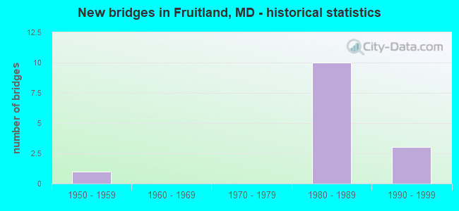
- New bridges - historical statistics
- 11950-1959
- 101980-1989
- 31990-1999


- Bridge Condition - Deck
- 33.3%Good
- 55.6%Satisfactory
- 11.1%Fair

- Bridge Condition - Superstructure
- 33.3%Good
- 33.3%Satisfactory
- 33.3%Fair

- Bridge Condition - Substructure
- 11.1%Good
- 55.6%Satisfactory
- 33.3%Fair

- Bridge Condition - Channel
- 50.0%Good
- 50.0%Satisfactory
Find on map >> Show street view
Structure Number: 100000220005011, Location: 0.38 MILE NORTH OF MD 513 (Lat: 38.333011, Lng: -75.610758), Route carried "on" structure: Business US 13, Year Built: 1995, Status: Open, Structure Length: 8.38m (27.49ft), Average Daily Traffic: 11,480 (year 2012), Truck Traffic: 13%, Average Future Daily Traffic: 14,924 (year 2032), Design Load: HS 25 or greater, Features Intersected: TONYTANK POND
Minimum Vertical Clearance: 30+ m (98+ ft), Kilometerpoint: 4.859, Lanes on structure: 2, Base Highway Network: Yes, Owner: State Highway Agency, Approaching Roadway Width: 11.6m (38.1ft), Material/Design: Prestressed concrete continuous, Design/Construction: Slab, Number Of Spans In Main Unit: 7, Length of Maximum Span: 12.2m (40.0ft), Curb-To-Curb Width: 11.6m (38.1ft), Out-to-Out Width: 12.8m (42.0ft)
Condition: Deck: Satisfactory, Superstructure: Good, Substructure: Good, Channel: Satisfactory, Operating Rating: 80.3 metric tons, Method Used To Determine Operating Rating: Load Factor (LF), Inventory Rating: 41.7 metric tons, Method Used To Determine Inventory Rating: Load Factor (LF), Structural Evaluation: Better than present minimum criteria, Deck Geometry: Better than present minimum criteria, Waterway Adequacy: Equal to present desirable criteria, Approach Roadway Alignment: Equal to present desirable criteria, Designated Inspection Frequency: Every 24 months, Underwater Inspection Frequency: Every 48 months, Inspection Date: March 2020, Underwater Inspection Date: July 2021, Deck Structure Type: Concrete Precast Panels, Wearing Surface/Protective System: Wearing Surface: Integral Concrete, Deck Protection: Epoxy Coated Reinforcing
Find on map >> Show street view
Structure Number: 100000220005012, Location: 0.34 MILE NORTH OF MD 513 (Lat: 38.333744, Lng: -75.607817), Route carried "on" structure: Business US 13, Year Built: 1954, Status: Open, Structure Length: 7.41m (24.31ft), Average Daily Traffic: 11,029 (year 2012), Truck Traffic: 8%, Average Future Daily Traffic: 14,338 (year 2032), Design Load: HS 20, Features Intersected: TONYTANK POND
Minimum Vertical Clearance: 30+ m (98+ ft), Kilometerpoint: 4.859, Lanes on structure: 2, Base Highway Network: Yes, Owner: State Highway Agency, Approaching Roadway Width: 10.4m (34.1ft), Material/Design: Concrete, Design/Construction: Slab, Number Of Spans In Main Unit: 12, Length of Maximum Span: 6.1m (20.0ft), Curb or Sidewalk Widths: Left: 0.9m (3.0ft), Right: 0.9m (3.0ft), Curb-To-Curb Width: 9.1m (29.9ft), Out-to-Out Width: 11.8m (38.7ft)
Condition: Deck: Fair, Superstructure: Fair, Substructure: Fair, Channel: Satisfactory, Operating Rating: 44.0 metric tons, Method Used To Determine Operating Rating: Load Factor (LF), Inventory Rating: 26.3 metric tons, Method Used To Determine Inventory Rating: Load Factor (LF), Structural Evaluation: Somewhat better than minimum adequacy, Deck Geometry: Meets minimum limits, Waterway Adequacy: Equal to present desirable criteria, Approach Roadway Alignment: Equal to present desirable criteria, Length Of Structure Improvement: 7.41m (24.31ft), Designated Inspection Frequency: Every 12 months, Underwater Inspection Frequency: Every 48 months, Inspection Date: March 2021, Underwater Inspection Date: July 2021, Bridge Improvement Cost: $564,000, Roadway Improvement Cost: $56,000, Total Project Cost: $620,000, Deck Structure Type: Concrete Cast-file-Place, Wearing Surface/Protective System: Wearing Surface: Bituminous
Find on map >> Show street view
Structure Number: 10000022004101, Location: 0.37 M S OF ST LUKES ROAD (Lat: 38.308281, Lng: -75.605094), Route carried "on" structure: State highway 513, Year Built: 1981, Status: Open, Structure Length: 6.77m (22.21ft), Average Daily Traffic: 7,990 (year 2009), Truck Traffic: 8%, Average Future Daily Traffic: 9,824 (year 2026), Design Load: HS 20, Features Intersected: US 13
Minimum Vertical Clearance: 30+ m (98+ ft), Kilometerpoint: 2.526, Lanes on structure: 4, Lanes under structure: 2, Owner: State Highway Agency, Approaching Roadway Width: 12.2m (40.0ft), Skew: 1 degrees, Material/Design: Steel continuous, Design/Construction: Stringer/Multi-beam, Number Of Spans In Main Unit: 2, Length of Maximum Span: 33.2m (108.9ft), Curb-To-Curb Width: 16.0m (52.5ft), Out-to-Out Width: 17.0m (55.8ft)
Condition: Deck: Satisfactory, Superstructure: Satisfactory, Substructure: Satisfactory, Operating Rating: 73.9 metric tons, Method Used To Determine Operating Rating: Load Factor (LF), Inventory Rating: 44.0 metric tons, Method Used To Determine Inventory Rating: Load Factor (LF), Structural Evaluation: Equal to present minimum criteria, Deck Geometry: Meets minimum limits, Underclear: Somewhat better than minimum adequacy, Approach Roadway Alignment: Equal to present desirable criteria, Designated Inspection Frequency: Every 24 months, Inspection Date: August 2021, Deck Structure Type: Concrete Cast-file-Place, Wearing Surface/Protective System: Wearing Surface: Monolithic Concrete
Find on map >> Show street view
Structure Number: 100000220042011, Location: 0.52 MILE SOUTH OF MD 513 (Lat: 38.304475, Lng: -75.613381), Route carried "on" structure: Bypass US 13, Year Built: 1981, Status: Open, Structure Length: 3.57m (11.71ft), Average Daily Traffic: 17,160 (year 2009), Truck Traffic: 8%, Average Future Daily Traffic: 10,872 (year 2026), Design Load: HS 20, Features Intersected: MEADOW BRIDGE ROAD
Minimum Vertical Clearance: 30+ m (98+ ft), Kilometerpoint: 3.540, Lanes on structure: 2, Lanes under structure: 2, Base Highway Network: Yes, Owner: State Highway Agency, Approaching Roadway Width: 11.6m (38.1ft), Skew: 2 degrees, Material/Design: Steel, Design/Construction: Stringer/Multi-beam, Number Of Spans In Main Unit: 1, Length of Maximum Span: 34.4m (112.9ft), Curb-To-Curb Width: 12.2m (40.0ft), Out-to-Out Width: 13.2m (43.3ft)
Condition: Deck: Good, Superstructure: Fair, Substructure: Fair, Operating Rating: 65.8 metric tons, Method Used To Determine Operating Rating: Load Factor (LF), Inventory Rating: 39.5 metric tons, Method Used To Determine Inventory Rating: Load Factor (LF), Structural Evaluation: Somewhat better than minimum adequacy, Deck Geometry: Better than present minimum criteria, Underclear: Equal to present minimum criteria, Approach Roadway Alignment: Equal to present desirable criteria, Length Of Structure Improvement: 3.57m (11.71ft), Designated Inspection Frequency: Every 24 months, Other Special Inspection Frequency: Every 12 months, Inspection Date: April 2021, Other Special Inspection Date: April 2021, Bridge Improvement Cost: $303,000, Roadway Improvement Cost: $30,000, Total Project Cost: $333,000, Deck Structure Type: Concrete Cast-file-Place, Wearing Surface/Protective System: Wearing Surface: Monolithic Concrete
Find on map >> Show street view
Structure Number: 100000220042012, Location: 0.52 MILE SOUTH OF MD 513 (Lat: 38.304839, Lng: -75.612961), Route carried "on" structure: Bypass US 13, Year Built: 1981, Status: Open, Structure Length: 3.57m (11.71ft), Average Daily Traffic: 17,160 (year 2009), Truck Traffic: 8%, Average Future Daily Traffic: 10,872 (year 2026), Design Load: HS 20, Features Intersected: MEADOW BRIDGE ROAD
Minimum Vertical Clearance: 30+ m (98+ ft), Kilometerpoint: 3.540, Lanes on structure: 2, Lanes under structure: 2, Base Highway Network: Yes, Owner: State Highway Agency, Approaching Roadway Width: 11.6m (38.1ft), Skew: 2 degrees, Material/Design: Steel, Design/Construction: Stringer/Multi-beam, Number Of Spans In Main Unit: 1, Length of Maximum Span: 34.4m (112.9ft), Curb-To-Curb Width: 12.2m (40.0ft), Out-to-Out Width: 13.2m (43.3ft)
Condition: Deck: Satisfactory, Superstructure: Fair, Substructure: Fair, Operating Rating: 63.9 metric tons, Method Used To Determine Operating Rating: Load Factor (LF), Inventory Rating: 38.5 metric tons, Method Used To Determine Inventory Rating: Load Factor (LF), Structural Evaluation: Somewhat better than minimum adequacy, Deck Geometry: Better than present minimum criteria, Underclear: Equal to present minimum criteria, Approach Roadway Alignment: Equal to present desirable criteria, Designated Inspection Frequency: Every 24 months, Other Special Inspection Frequency: Every 12 months, Inspection Date: April 2021, Other Special Inspection Date: April 2021, Deck Structure Type: Concrete Cast-file-Place, Wearing Surface/Protective System: Wearing Surface: Monolithic Concrete
Find on map >> Show street view
Structure Number: 100000220043011, Location: 0.47 MILE N OF US 13 BUS (Lat: 38.301406, Lng: -75.635169), Route carried "on" structure: US 13, Year Built: 1980, Status: Open, Structure Length: 10.12m (33.20ft), Average Daily Traffic: 17,160 (year 2009), Truck Traffic: 8%, Average Future Daily Traffic: 10,872 (year 2026), Design Load: HS 20, Features Intersected: US 13 BU NB AND NORFOLK
Minimum Vertical Clearance: 30+ m (98+ ft), Kilometerpoint: 1.604, Lanes on structure: 2, Lanes under structure: 2, Base Highway Network: Yes, Owner: State Highway Agency, Approaching Roadway Width: 11.6m (38.1ft), Skew: 4 degrees, Material/Design: Steel continuous, Design/Construction: Stringer/Multi-beam, Number Of Spans In Main Unit: 4, Length of Maximum Span: 35.1m (115.2ft), Curb-To-Curb Width: 12.1m (39.7ft), Out-to-Out Width: 13.1m (43.0ft)
Condition: Deck: Satisfactory, Superstructure: Satisfactory, Substructure: Satisfactory, Operating Rating: 38.5 metric tons, Method Used To Determine Operating Rating: Load Factor (LF), Inventory Rating: 23.1 metric tons, Method Used To Determine Inventory Rating: Load Factor (LF), Structural Evaluation: Somewhat better than minimum adequacy, Deck Geometry: Equal to present minimum criteria, Underclear: Somewhat better than minimum adequacy, Approach Roadway Alignment: Equal to present desirable criteria, Designated Inspection Frequency: Every 24 months, Inspection Date: December 2020, Deck Structure Type: Concrete Cast-file-Place, Wearing Surface/Protective System: Wearing Surface: Monolithic Concrete
Find on map >> Show street view
Structure Number: 100000220043012, Location: 0.47 MILE N OF US 13 BUS (Lat: 38.301928, Lng: -75.633881), Route carried "on" structure: US 13, Year Built: 1980, Status: Open, Structure Length: 9.72m (31.89ft), Average Daily Traffic: 17,160 (year 2009), Truck Traffic: 8%, Average Future Daily Traffic: 10,872 (year 2026), Design Load: HS 20, Features Intersected: US 13 BU NB AND NORFOLK
Minimum Vertical Clearance: 30+ m (98+ ft), Kilometerpoint: 1.604, Lanes on structure: 2, Lanes under structure: 2, Base Highway Network: Yes, Owner: State Highway Agency, Approaching Roadway Width: 11.6m (38.1ft), Skew: 4 degrees, Material/Design: Steel continuous, Design/Construction: Stringer/Multi-beam, Number Of Spans In Main Unit: 4, Length of Maximum Span: 32.3m (106.0ft), Curb-To-Curb Width: 12.1m (39.7ft), Out-to-Out Width: 13.1m (43.0ft)
Condition: Deck: Satisfactory, Superstructure: Satisfactory, Substructure: Satisfactory, Operating Rating: 53.1 metric tons, Method Used To Determine Operating Rating: Load Factor (LF), Inventory Rating: 31.3 metric tons, Method Used To Determine Inventory Rating: Load Factor (LF), Structural Evaluation: Equal to present minimum criteria, Deck Geometry: Equal to present minimum criteria, Underclear: Somewhat better than minimum adequacy, Approach Roadway Alignment: Equal to present desirable criteria, Designated Inspection Frequency: Every 24 months, Inspection Date: December 2020, Deck Structure Type: Concrete Cast-file-Place, Wearing Surface/Protective System: Wearing Surface: Monolithic Concrete
Find on map >> Show street view
Structure Number: 200000WI307101, Location: .75 MI S SALSBRY CTY LINE (Lat: 38.341592, Lng: -75.625850), Route carried "on" structure: County highway 153, Year Built: 1999, Status: Open, Structure Length: 4.30m (14.11ft), Average Daily Traffic: 3,490 (year 2020), Truck Traffic: 5%, Average Future Daily Traffic: 4,313 (year 2040), Design Load: HS 20, Features Intersected: TONY TANK CREEK, Facility Carried by Structure: RIVERSIDE DRIVE
Minimum Vertical Clearance: 30+ m (98+ ft), Kilometerpoint: 1.577, Lanes on structure: 2, Base Highway Network: Yes, Owner: County Highway Agency, Approaching Roadway Width: 7.0m (23.0ft), Material/Design: Wood or Timber, Design/Construction: Slab, Number Of Spans In Main Unit: 6, Length of Maximum Span: 7.0m (23.0ft), Curb or Sidewalk Widths: Left: 1.2m (3.9ft), Right: 1.2m (3.9ft), Curb-To-Curb Width: 8.5m (27.9ft), Out-to-Out Width: 11.6m (38.1ft)
Condition: Deck: Good, Superstructure: Good, Substructure: Satisfactory, Channel: Good, Operating Rating: 73.5 metric tons, Method Used To Determine Operating Rating: Allowable Stress (AS), Inventory Rating: 52.2 metric tons, Method Used To Determine Inventory Rating: Allowable Stress (AS), Structural Evaluation: Equal to present minimum criteria, Deck Geometry: Meets minimum limits, Waterway Adequacy: Equal to present minimum criteria, Approach Roadway Alignment: Equal to present minimum criteria, Designated Inspection Frequency: Every 24 months, Underwater Inspection Frequency: Every 48 months, Inspection Date: November 2020, Underwater Inspection Date: November 2020, Wearing Surface/Protective System: Wearing Surface: Bituminous, Membrane: Preformed Fabric
Find on map >> Show street view
Structure Number: 200000WI309101, Location: 2 MI SW UPPER FERRY CROSS (Lat: 38.323403, Lng: -75.722475), Route carried "on" structure: County highway 143, Year Built: 1997, Status: Open, Structure Length: 1.13m (3.71ft), Average Daily Traffic: 1,035 (year 2020), Truck Traffic: 5%, Average Future Daily Traffic: 1,310 (year 2040), Design Load: HS 20, Features Intersected: CUTMAPTICO CREEK, Facility Carried by Structure: COOPER ROAD
Minimum Vertical Clearance: 30+ m (98+ ft), Kilometerpoint: 3.475, Lanes on structure: 2, Base Highway Network: Yes, Owner: County Highway Agency, Approaching Roadway Width: 4.9m (16.1ft), Material/Design: Wood or Timber, Design/Construction: Slab, Number Of Spans In Main Unit: 2, Length of Maximum Span: 5.8m (19.0ft), Curb-To-Curb Width: 7.3m (24.0ft), Out-to-Out Width: 7.9m (25.9ft)
Condition: Deck: Good, Superstructure: Good, Substructure: Satisfactory, Channel: Good, Structural Evaluation: Equal to present minimum criteria, Deck Geometry: Meets minimum limits, Waterway Adequacy: Better than present minimum criteria, Approach Roadway Alignment: Equal to present minimum criteria, Length Of Structure Improvement: 1.07m (3.51ft), Designated Inspection Frequency: Every 24 months, Inspection Date: October 2020, Deck Structure Type: Wood or Timber, Wearing Surface/Protective System: Wearing Surface: Bituminous
Find on map >> Show street view
Structure Number: 10000022004101, Location: 1.71 M N OF US 13 BUS (Lat: 38.308281, Lng: -75.605094), Route carried "under" structure: US 13, Year Built: 1981, Structure Length: 0. m, Average Daily Traffic: 23,950 (year 2009), Truck Traffic: 8%, Features Intersected: US 13
Minimum Vertical Clearance: 5.18m (16.99ft), Kilometerpoint: 4.393, Lanes on structure: 4, Lanes under structure: 2, Material/Design: Steel continuous, Design/Construction: Stringer/Multi-beam, Length of Maximum Span: 33.2m (108.9ft)
Find on map >> Show street view
Structure Number: 100000220042011, Location: 0.52 MI S OF MD 513 (Lat: 38.304475, Lng: -75.613381), Route carried "under" structure: County highway 172, Year Built: 1981, Structure Length: 0. m, Features Intersected: MEADOW BRIDGE ROAD, Facility Carried by Structure: US 13 NBR
Minimum Vertical Clearance: 4.88m (16.01ft), Kilometerpoint: 0.354, Lanes on structure: 2, Lanes under structure: 2, Material/Design: Steel, Design/Construction: Stringer/Multi-beam, Length of Maximum Span: 34.4m (112.9ft)
Find on map >> Show street view
Structure Number: 100000220042012, Location: 0.52 MI S OF MD 513 (Lat: 38.304839, Lng: -75.612961), Route carried "under" structure: County highway 172, Year Built: 1981, Structure Length: 0. m, Features Intersected: MEADOW BRIDGE ROAD, Facility Carried by Structure: US 13 SBR
Minimum Vertical Clearance: 5.18m (16.99ft), Kilometerpoint: 0.386, Lanes on structure: 2, Lanes under structure: 2, Material/Design: Steel, Design/Construction: Stringer/Multi-beam, Length of Maximum Span: 34.4m (112.9ft)
Find on map >> Show street view
Structure Number: 100000220043011, Location: 0.43 MILE NORTH OF US 13 (Lat: 38.301406, Lng: -75.635169), Route carried "under" structure: Business US 13, Year Built: 1980, Structure Length: 0. m, Average Daily Traffic: 13,070 (year 2009), Truck Traffic: 8%, Features Intersected: US 13 BU NB, NO'FK SO RR
Minimum Vertical Clearance: 6.40m (21.00ft), Kilometerpoint: 0.692, Lanes on structure: 2, Lanes under structure: 2, Material/Design: Steel continuous, Design/Construction: Stringer/Multi-beam, Length of Maximum Span: 35.1m (115.2ft)
Find on map >> Show street view
Structure Number: 100000220043012, Location: 0.43 MILE NORTH OF US 13 (Lat: 38.301928, Lng: -75.633881), Route carried "under" structure: Business US 13, Year Built: 1980, Structure Length: 0. m, Average Daily Traffic: 13,070 (year 2009), Truck Traffic: 8%, Features Intersected: US 13 BU NB, NO'FK SO RR
Minimum Vertical Clearance: 6.40m (21.00ft), Kilometerpoint: 0.692, Lanes on structure: 2, Lanes under structure: 2, Material/Design: Steel continuous, Design/Construction: Stringer/Multi-beam, Length of Maximum Span: 32.3m (106.0ft)