Bridge Statistics for Fruitland, Idaho (ID)
Condition, Traffic, Stress, Structural Evaluation, Project Costs
- National Bridge Inventory (NBI) Statistics
- 16Number of bridges
- 430ft / 131mTotal length
- $33,577,000Total costs
- 159,970Total average daily traffic
- 25,669Total average daily truck traffic
- National Bridge Inventory (NBI) Registered Bridges for Fruitland
- No street view available for this location
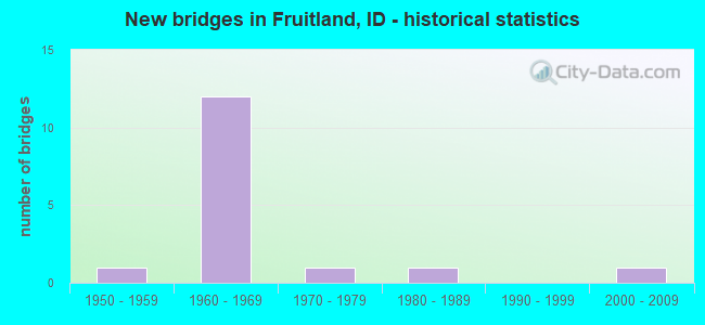
- New bridges - historical statistics
- 11950-1959
- 121960-1969
- 11970-1979
- 11980-1989
- 12000-2009

- Reconstructed bridges - Historical Statistics
- 11980-1989
- 01990-1999
- 12000-2009


- Bridge Condition - Deck
- 36.4%Good
- 45.5%Satisfactory
- 18.2%Fair

- Bridge Condition - Superstructure
- 27.3%Good
- 45.5%Satisfactory
- 27.3%Fair

- Bridge Condition - Substructure
- 18.2%Good
- 63.6%Satisfactory
- 18.2%Fair

- Bridge Condition - Channel
- 16.7%Very good
- 66.7%Good
- 16.7%Satisfactory
Find on map >> Show street view
Structure Number: 13795, Location: 0.6 W. FRUITLAND (Lat: 44.024722, Lng: -116.935000), Route carried "on" structure: Spur US 30, Year Built: 1967, Year Reconstructed: 1985, Status: Open, Structure Length: 27.04m (88.71ft), Average Daily Traffic: 22,300 (year 2019), Truck Traffic: 2%, Average Future Daily Traffic: 33,450 (year 2039), Design Load: HS 20, Features Intersected: SNAKE R;FRUITLAND BRIDGE
Minimum Vertical Clearance: 30+ m (98+ ft), Kilometerpoint: 0.000, Lanes on structure: 4, Base Highway Network: Yes (Inventory Route: US0, Subroute: 1), Owner: State Highway Agency, Approaching Roadway Width: 20.7m (67.9ft), Navigation Control: Yes ( Vertical Clearance: 8.2m (26.9ft), Horizontal Clearance: 59.1m (193.9ft)), Material/Design: Prestressed concrete continuous, Design/Construction: Stringer/Multi-beam, Number Of Spans In Main Unit: 9, Length of Maximum Span: 30.8m (101.0ft), Curb or Sidewalk Widths: Left: 0.0m, Right: 1.5m (4.9ft), Curb-To-Curb Width: 20.7m (67.9ft), Out-to-Out Width: 23.6m (77.4ft)
Condition: Deck: Good, Superstructure: Fair, Substructure: Fair, Channel: Satisfactory, Operating Rating: 27.1 metric tons, Method Used To Determine Operating Rating: Load Factor (LF), Inventory Rating: 20.9 metric tons, Method Used To Determine Inventory Rating: Load Factor (LF), Structural Evaluation: Somewhat better than minimum adequacy, Deck Geometry: Superior to present desirable criteria, Waterway Adequacy: Equal to present desirable criteria, Approach Roadway Alignment: Equal to present desirable criteria, Designated Inspection Frequency: Every 24 months, Underwater Inspection Frequency: Every 36 months, Inspection Date: October 2020, Underwater Inspection Date: September 2020, Deck Structure Type: Concrete Cast-file-Place, Wearing Surface/Protective System: Wearing Surface: Bituminous, Membrane: Preformed Fabric, Deck Protection: Epoxy Coated Reinforcing
Find on map >> Show street view
Structure Number: 15325, Location: 2.0 E. OREGON-IDAHO LINE (Lat: 43.979167, Lng: -116.923583), Route carried "on" structure: Interstate 84, Year Built: 1960, Status: Open, Structure Length: 0.79m (2.59ft), Average Daily Traffic: 10,750 (year 2019), Truck Traffic: 23%, Average Future Daily Traffic: 16,125 (year 2039), Design Load: HS 20, Features Intersected: WHITLEY ROAD GS
Minimum Vertical Clearance: 30+ m (98+ ft), Kilometerpoint: 3.413, Lanes on structure: 2, Lanes under structure: 2, Base Highway Network: Yes, Owner: State Highway Agency, Approaching Roadway Width: 12.7m (41.7ft), Material/Design: Concrete, Design/Construction: Frame, Number Of Spans In Main Unit: 1, Length of Maximum Span: 7.3m (24.0ft), Curb-To-Curb Width: 12.2m (40.0ft), Out-to-Out Width: 14.6m (47.9ft)
Condition: Deck: Good, Superstructure: Good, Substructure: Good, Operating Rating: 50.8 metric tons, Method Used To Determine Operating Rating: Load Factor (LF), Inventory Rating: 29.9 metric tons, Method Used To Determine Inventory Rating: Load Factor (LF), Structural Evaluation: Better than present minimum criteria, Deck Geometry: Better than present minimum criteria, Underclear: High priority of corrective action, Approach Roadway Alignment: Equal to present desirable criteria, Designated Inspection Frequency: Every 24 months, Inspection Date: April 2021, Deck Structure Type: Concrete Cast-file-Place, Wearing Surface/Protective System: Wearing Surface: Bituminous
Find on map >> Show street view
Structure Number: 15335, Location: 2.0 E. OREGON-IDAHO LINE (Lat: 43.979286, Lng: -116.923211), Route carried "on" structure: Interstate 84, Year Built: 1960, Status: Open, Structure Length: 0.79m (2.59ft), Average Daily Traffic: 10,750 (year 2019), Truck Traffic: 23%, Average Future Daily Traffic: 16,125 (year 2039), Design Load: HS 20, Features Intersected: WHITLEY ROAD GS
Minimum Vertical Clearance: 30+ m (98+ ft), Kilometerpoint: 3.412, Lanes on structure: 2, Lanes under structure: 2, Base Highway Network: Yes, Owner: State Highway Agency, Approaching Roadway Width: 12.7m (41.7ft), Material/Design: Concrete, Design/Construction: Frame, Number Of Spans In Main Unit: 1, Length of Maximum Span: 7.3m (24.0ft), Curb-To-Curb Width: 12.2m (40.0ft), Out-to-Out Width: 14.6m (47.9ft)
Condition: Deck: Good, Superstructure: Good, Substructure: Good, Operating Rating: 52.6 metric tons, Method Used To Determine Operating Rating: Load Factor (LF), Inventory Rating: 30.8 metric tons, Method Used To Determine Inventory Rating: Load Factor (LF), Structural Evaluation: Better than present minimum criteria, Deck Geometry: Better than present minimum criteria, Underclear: High priority of corrective action, Approach Roadway Alignment: Equal to present desirable criteria, Designated Inspection Frequency: Every 24 months, Inspection Date: April 2021, Deck Structure Type: Concrete Cast-file-Place, Wearing Surface/Protective System: Wearing Surface: Bituminous
Find on map >> Show street view
Structure Number: 18095, Location: 23.2 W. CALDWELL (Lat: 43.971667, Lng: -116.914028), Route carried "on" structure: US 95, Year Built: 1960, Status: Open, Structure Length: 9.63m (31.59ft), Average Daily Traffic: 7,800 (year 2019), Truck Traffic: 6%, Average Future Daily Traffic: 11,700 (year 2039), Design Load: HS 20, Features Intersected: I 84 EB-WB;US 95 IC
Minimum Vertical Clearance: 30+ m (98+ ft), Kilometerpoint: 97.879, Lanes on structure: 2, Lanes under structure: 4, Base Highway Network: Yes (Inventory Route: US0, Subroute: 1), Owner: State Highway Agency, Approaching Roadway Width: 17.7m (58.1ft), Skew: 4 degrees, Material/Design: Prestressed concrete, Design/Construction: Stringer/Multi-beam, Number Of Spans In Main Unit: 3, Number Of Approach Spans: 2, Length of Maximum Span: 22.7m (74.5ft), Curb-To-Curb Width: 16.5m (54.1ft), Out-to-Out Width: 17.9m (58.7ft)
Condition: Deck: Fair, Superstructure: Fair, Substructure: Fair, Operating Rating: 50.8 metric tons, Method Used To Determine Operating Rating: Load Factor (LF), Inventory Rating: 30.8 metric tons, Method Used To Determine Inventory Rating: Load Factor (LF), Structural Evaluation: Somewhat better than minimum adequacy, Deck Geometry: Superior to present desirable criteria, Underclear: Meets minimum limits, Approach Roadway Alignment: Equal to present desirable criteria, Length Of Structure Improvement: 10.67m (35.01ft), Designated Inspection Frequency: Every 24 months, Inspection Date: June 2020, Bridge Improvement Cost: $2,772,000, Roadway Improvement Cost: $277,000, Total Project Cost: $4,158,000 ( Estimate for 2020), Deck Structure Type: Concrete Cast-file-Place, Wearing Surface/Protective System: Wearing Surface: Latex Concrete
Find on map >> Show street view
Structure Number: 1811, Location: 1.8 S. PAYETTE SCL (Lat: 44.041500, Lng: -116.926361), Route carried "on" structure: US 95, Year Built: 1968, Year Reconstructed: 2012, Status: Open, Structure Length: 14.75m (48.39ft), Average Daily Traffic: 19,000 (year 2019), Truck Traffic: 7%, Average Future Daily Traffic: 28,500 (year 2039), Design Load: HS 20, Features Intersected: PAYETTE RIVER
Minimum Vertical Clearance: 30+ m (98+ ft), Kilometerpoint: 106.513, Lanes on structure: 5, Base Highway Network: Yes (Inventory Route: US0, Subroute: 1), Owner: State Highway Agency, Approaching Roadway Width: 24.4m (80.1ft), Skew: 5 degrees, Material/Design: Prestressed concrete, Design/Construction: Stringer/Multi-beam, Number Of Spans In Main Unit: 6, Length of Maximum Span: 24.0m (78.7ft), Curb-To-Curb Width: 24.8m (81.4ft), Out-to-Out Width: 25.6m (84.0ft)
Condition: Deck: Satisfactory, Superstructure: Good, Substructure: Satisfactory, Channel: Good, Operating Rating: 65.3 metric tons, Method Used To Determine Operating Rating: Load Factor (LF), Inventory Rating: 32.7 metric tons, Method Used To Determine Inventory Rating: Load Factor (LF), Structural Evaluation: Equal to present minimum criteria, Deck Geometry: Superior to present desirable criteria, Waterway Adequacy: Equal to present desirable criteria, Approach Roadway Alignment: Equal to present desirable criteria, Designated Inspection Frequency: Every 24 months, Underwater Inspection Frequency: Every 60 months, Inspection Date: September 2020, Underwater Inspection Date: August 2018, Deck Structure Type: Concrete Cast-file-Place, Wearing Surface/Protective System: Wearing Surface: Low Slump Concrete, Deck Protection: Epoxy Coated Reinforcing
Find on map >> Show street view
Structure Number: 21495, Location: IN LEWISTON;BRYDEN EXT (Lat: 46.396667, Lng: -117.043222), Route carried "on" structure: City street 7344, Year Built: 1982, Status: Open, Structure Length: 56.88m (186.61ft), Average Daily Traffic: 20,500 (year 2019), Truck Traffic: 7%, Average Future Daily Traffic: 30,750 (year 2039), Design Load: HS 20, Features Intersected: SNAKE R;HIGH/SOUTHWAY BR
Minimum Vertical Clearance: 30+ m (98+ ft), Kilometerpoint: 0.000, Lanes on structure: 4, Lanes under structure: 2, Owner: County Highway Agency, Approaching Roadway Width: 16.4m (53.8ft), Skew: 20 degrees, Navigation Control: Yes ( Vertical Clearance: 19.0m (62.3ft), Horizontal Clearance: 76.0m (249.3ft)), Material/Design: Prestressed concrete continuous, Design/Construction: Box Beam or Girders - Single/Spread, Number Of Spans In Main Unit: 5, Length of Maximum Span: 185.9m (609.9ft), Curb or Sidewalk Widths: Left: 1.5m (4.9ft), Right: 1.8m (5.9ft), Curb-To-Curb Width: 16.4m (53.8ft), Out-to-Out Width: 21.3m (69.9ft)
Condition: Deck: Satisfactory, Superstructure: Satisfactory, Substructure: Satisfactory, Channel: Very good, Operating Rating: 54.4 metric tons, Method Used To Determine Operating Rating: Assigned rating based on Load Factor Design (LFD) reported in metric tons, Inventory Rating: 32.7 metric tons, Method Used To Determine Inventory Rating: Assigned rating based on Load Factor Design (LFD) reported in metric tons, Structural Evaluation: Equal to present minimum criteria, Deck Geometry: Meets minimum limits, Underclear: Meets minimum limits, Waterway Adequacy: Superior to present desirable criteria, Approach Roadway Alignment: Equal to present minimum criteria, Length Of Structure Improvement: 56.88m (186.61ft), Designated Inspection Frequency: Every 24 months, Underwater Inspection Frequency: Every 60 months, Inspection Date: September 2020, Underwater Inspection Date: September 2020, Bridge Improvement Cost: $19,089,000, Roadway Improvement Cost: $1,909,000, Total Project Cost: $28,634,000 ( Estimate for 2018), Deck Structure Type: Concrete Cast-file-Place, Wearing Surface/Protective System: Wearing Surface: Bituminous
Find on map >> Show street view
Structure Number: 28403, Location: 2.2 S 3.5 W NEW PLYMOUTH (Lat: 43.944039, Lng: -116.889958), Route carried "on" structure: County highway , Year Built: 2003, Status: Posted for load, Structure Length: 1.65m (5.41ft), Average Daily Traffic: 100 (year 2020), Truck Traffic: 10%, Average Future Daily Traffic: 150 (year 2040), Design Load: HS 20, Features Intersected: A LINE CANAL, Facility Carried by Structure: SW 3 1/2 AVE
Minimum Vertical Clearance: 30+ m (98+ ft), Kilometerpoint: 0.309, Lanes on structure: 2, Owner: Local Agency, Approaching Roadway Width: 9.8m (32.2ft), Material/Design: Steel, Design/Construction: Stringer/Multi-beam, Number Of Spans In Main Unit: 1, Length of Maximum Span: 11.6m (38.1ft), Curb-To-Curb Width: 9.1m (29.9ft), Out-to-Out Width: 9.4m (30.8ft)
Condition: Deck: Satisfactory, Superstructure: Satisfactory, Substructure: Satisfactory, Channel: Good, Operating Rating: 27.2 metric tons, Method Used To Determine Operating Rating: Load Factor (LF), Inventory Rating: 16.3 metric tons, Method Used To Determine Inventory Rating: Load Factor (LF), Structural Evaluation: Somewhat better than minimum adequacy, Deck Geometry: Better than present minimum criteria, Waterway Adequacy: Equal to present desirable criteria, Approach Roadway Alignment: Equal to present desirable criteria, Length Of Structure Improvement: 1.86m (6.10ft), Designated Inspection Frequency: Every 24 months, Inspection Date: December 2020, Bridge Improvement Cost: $362,000, Roadway Improvement Cost: $36,000, Total Project Cost: $399,000 ( Estimate for 2020), Deck Structure Type: Concrete Cast-file-Place, Wearing Surface/Protective System: Wearing Surface: Monolithic Concrete
Find on map >> Show street view
Structure Number: 2845, Location: 2.1 N. 2.1 E. FRUITLAND (Lat: 44.039833, Lng: -116.871583), Route carried "on" structure: County highway , Year Built: 1959, Status: Posted for load, Structure Length: 0.94m (3.08ft), Average Daily Traffic: 510 (year 2019), Truck Traffic: 18%, Average Future Daily Traffic: 765 (year 2039), Design Load: H 15, Features Intersected: LOWER PAYETTE DITCH, Facility Carried by Structure: KILLEBREW DRIVE
Minimum Vertical Clearance: 30+ m (98+ ft), Kilometerpoint: 165.450, Lanes on structure: 2, Owner: County Highway Agency, Approaching Roadway Width: 7.3m (24.0ft), Skew: 4 degrees, Material/Design: Concrete, Design/Construction: Slab, Number Of Spans In Main Unit: 1, Length of Maximum Span: 9.1m (29.9ft), Curb or Sidewalk Widths: Left: 0.1m (0.3ft), Right: 0.1m (0.3ft), Curb-To-Curb Width: 8.8m (28.9ft), Out-to-Out Width: 9.1m (29.9ft)
Condition: Deck: Fair, Superstructure: Fair, Substructure: Satisfactory, Channel: Good, Operating Rating: 27.2 metric tons, Method Used To Determine Operating Rating: Field evaluation and documented engineering judgment, Inventory Rating: 16.3 metric tons, Method Used To Determine Inventory Rating: Field evaluation and documented engineering judgment, Structural Evaluation: Meets minimum limits, Deck Geometry: Somewhat better than minimum adequacy, Waterway Adequacy: Equal to present desirable criteria, Approach Roadway Alignment: Equal to present desirable criteria, Bridge Posting: Required (Relationship of Operating Rating to Maximum Legal Load: 10.0 - 19.9% below), Length Of Structure Improvement: 1.58m (5.18ft), Designated Inspection Frequency: Every 24 months, Inspection Date: November 2020, Bridge Improvement Cost: $257,000, Roadway Improvement Cost: $26,000, Total Project Cost: $386,000 ( Estimate for 2020), Deck Structure Type: Concrete Cast-file-Place, Wearing Surface/Protective System: Wearing Surface: Bituminous
Find on map >> Show street view
Structure Number: 28455, Location: 22.8 W. CALDWELL (Lat: 43.967361, Lng: -116.909833), Route carried "on" structure: County highway , Year Built: 1960, Status: Open, Structure Length: 9.14m (29.99ft), Average Daily Traffic: 540 (year 2019), Truck Traffic: 10%, Average Future Daily Traffic: 810 (year 2039), Design Load: HS 20, Features Intersected: I 84;FIRST ST SOUTH GS, Facility Carried by Structure: FIRST ST.SOUTH
Minimum Vertical Clearance: 30+ m (98+ ft), Kilometerpoint: 162.325, Lanes on structure: 2, Lanes under structure: 4, Owner: State Highway Agency, Approaching Roadway Width: 7.3m (24.0ft), Skew: 4 degrees, Material/Design: Prestressed concrete, Design/Construction: Stringer/Multi-beam, Number Of Spans In Main Unit: 3, Number Of Approach Spans: 2, Length of Maximum Span: 21.5m (70.5ft), Curb-To-Curb Width: 7.3m (24.0ft), Out-to-Out Width: 8.7m (28.5ft)
Condition: Deck: Satisfactory, Superstructure: Satisfactory, Substructure: Satisfactory, Operating Rating: 54.4 metric tons, Method Used To Determine Operating Rating: Load Factor (LF), Inventory Rating: 32.7 metric tons, Method Used To Determine Inventory Rating: Load Factor (LF), Structural Evaluation: Equal to present minimum criteria, Deck Geometry: Meets minimum limits, Underclear: Somewhat better than minimum adequacy, Approach Roadway Alignment: Equal to present minimum criteria, Designated Inspection Frequency: Every 24 months, Inspection Date: June 2020, Deck Structure Type: Concrete Cast-file-Place, Wearing Surface/Protective System: Wearing Surface: Latex Concrete
Find on map >> Show street view
Structure Number: 28465, Location: 21.7 W. CALDWELL (Lat: 43.955083, Lng: -116.893750), Route carried "on" structure: County highway , Year Built: 1960, Status: Open, Structure Length: 9.14m (29.99ft), Average Daily Traffic: 90 (year 2019), Truck Traffic: 11%, Average Future Daily Traffic: 135 (year 2039), Design Load: HS 20, Features Intersected: I 84;ELMORE AVENUE GS, Facility Carried by Structure: ELMORE AVENUE
Minimum Vertical Clearance: 30+ m (98+ ft), Kilometerpoint: 173.803, Lanes on structure: 2, Lanes under structure: 4, Owner: State Highway Agency, Approaching Roadway Width: 7.3m (24.0ft), Skew: 4 degrees, Material/Design: Prestressed concrete, Design/Construction: Stringer/Multi-beam, Number Of Spans In Main Unit: 3, Number Of Approach Spans: 2, Length of Maximum Span: 21.1m (69.2ft), Curb or Sidewalk Widths: Left: 0.5m (1.6ft), Right: 0.5m (1.6ft), Curb-To-Curb Width: 7.3m (24.0ft), Out-to-Out Width: 8.7m (28.5ft)
Condition: Deck: Satisfactory, Superstructure: Satisfactory, Substructure: Satisfactory, Operating Rating: 53.5 metric tons, Method Used To Determine Operating Rating: Load Factor (LF), Inventory Rating: 31.8 metric tons, Method Used To Determine Inventory Rating: Load Factor (LF), Structural Evaluation: Equal to present minimum criteria, Deck Geometry: Equal to present minimum criteria, Underclear: Somewhat better than minimum adequacy, Approach Roadway Alignment: Equal to present minimum criteria, Designated Inspection Frequency: Every 24 months, Inspection Date: June 2021, Deck Structure Type: Concrete Cast-file-Place, Wearing Surface/Protective System: Wearing Surface: Latex Concrete
Find on map >> Show street view
Structure Number: 3193, Location: 0.6 S. 2.5 W. EGIN (Lat: 43.927167, Lng: -111.889194), Route carried "on" structure: County highway , Year Built: 1978, Status: Open, Structure Length: 0.73m (2.40ft), Average Daily Traffic: 70 (year 2019), Truck Traffic: 10%, Average Future Daily Traffic: 105 (year 2039), Design Load: H 20, Features Intersected: ST. ANTHONY CANAL, Facility Carried by Structure: E 300 N
Minimum Vertical Clearance: 30+ m (98+ ft), Kilometerpoint: 161.623, Lanes on structure: 2, Owner: County Highway Agency, Approaching Roadway Width: 7.3m (24.0ft), Skew: 4 degrees, Material/Design: Prestressed concrete, Design/Construction: Tee Beam, Number Of Spans In Main Unit: 1, Length of Maximum Span: 7.0m (23.0ft), Curb or Sidewalk Widths: Left: 0.3m (1.0ft), Right: 0.3m (1.0ft), Curb-To-Curb Width: 8.0m (26.2ft), Out-to-Out Width: 8.5m (27.9ft)
Condition: Deck: Good, Superstructure: Satisfactory, Substructure: Satisfactory, Channel: Good, Operating Rating: 34.5 metric tons, Method Used To Determine Operating Rating: Field evaluation and documented engineering judgment, Inventory Rating: 20.9 metric tons, Method Used To Determine Inventory Rating: Field evaluation and documented engineering judgment, Structural Evaluation: Equal to present minimum criteria, Deck Geometry: Equal to present minimum criteria, Waterway Adequacy: Better than present minimum criteria, Approach Roadway Alignment: Equal to present desirable criteria, Designated Inspection Frequency: Every 24 months, Inspection Date: November 2020, Deck Structure Type: Concrete Cast-file-Place, Wearing Surface/Protective System: Wearing Surface: Bituminous
Find on map >> Show street view
Structure Number: 15325, Location: 2.0 E. OREGON-IDAHO LINE (Lat: 43.979167, Lng: -116.923583), Route carried "under" structure: County highway , Year Built: 1960, Structure Length: 0. m, Average Daily Traffic: 30 (year 2018), Features Intersected: WHITLEY ROAD GS, Facility Carried by Structure: I 84 EBL
Minimum Vertical Clearance: 4.29m (14.07ft), Kilometerpoint: 169.338, Lanes on structure: 2, Lanes under structure: 2, Material/Design: Concrete, Design/Construction: Frame, Length of Maximum Span: 7.3m (24.0ft)
Find on map >> Show street view
Structure Number: 15335, Location: 2.0 E. OREGON-IDAHO LINE (Lat: 43.979286, Lng: -116.923211), Route carried "under" structure: County highway , Year Built: 1960, Structure Length: 0. m, Average Daily Traffic: 30 (year 2018), Features Intersected: WHITLEY ROAD GS, Facility Carried by Structure: I 84 WBL
Minimum Vertical Clearance: 4.14m (13.58ft), Kilometerpoint: 169.354, Lanes on structure: 2, Lanes under structure: 2, Material/Design: Concrete, Design/Construction: Frame, Length of Maximum Span: 7.3m (24.0ft)
Find on map >> Show street view
Structure Number: 18095, Location: 23.2 W. CALDWELL (Lat: 43.971667, Lng: -116.914028), Route carried "under" structure: Interstate 84, Year Built: 1960, Structure Length: 0. m, Average Daily Traffic: 22,500 (year 2018), Truck Traffic: 25%, Features Intersected: I 84 EB-WB;US 95 IC, Facility Carried by Structure: US 95
Minimum Vertical Clearance: 5.28m (17.32ft), Kilometerpoint: 4.608, Lanes on structure: 2, Lanes under structure: 4, Material/Design: Prestressed concrete, Design/Construction: Stringer/Multi-beam, Length of Maximum Span: 22.7m (74.5ft)
Find on map >> Show street view
Structure Number: 28455, Location: 22.8 W. CALDWELL (Lat: 43.967361, Lng: -116.909833), Route carried "under" structure: Interstate 84, Year Built: 1960, Structure Length: 0. m, Average Daily Traffic: 22,500 (year 2018), Truck Traffic: 25%, Features Intersected: I 84;FIRST ST SOUTH GS, Facility Carried by Structure: FIRST ST.SOUTH
Minimum Vertical Clearance: 5.61m (18.41ft), Kilometerpoint: 5.161, Lanes on structure: 2, Lanes under structure: 4, Material/Design: Prestressed concrete, Design/Construction: Stringer/Multi-beam, Length of Maximum Span: 21.5m (70.5ft)
Find on map >> Show street view
Structure Number: 28465, Location: 21.7 W. CALDWELL (Lat: 43.955083, Lng: -116.893750), Route carried "under" structure: Interstate 84, Year Built: 1960, Structure Length: 0. m, Average Daily Traffic: 22,500 (year 2018), Truck Traffic: 25%, Features Intersected: I 84;ELMORE AVENUE GS, Facility Carried by Structure: ELMORE AVENUE
Minimum Vertical Clearance: 5.49m (18.01ft), Kilometerpoint: 7.002, Lanes on structure: 2, Lanes under structure: 4, Material/Design: Prestressed concrete, Design/Construction: Stringer/Multi-beam, Length of Maximum Span: 21.1m (69.2ft)