Bridge Statistics for Friendsville, Maryland (MD)
Condition, Traffic, Stress, Structural Evaluation, Project Costs
- National Bridge Inventory (NBI) Statistics
- 32Number of bridges
- 509ft / 155mTotal length
- $1,108,000Total costs
- 179,550Total average daily traffic
- 12,148Total average daily truck traffic
- National Bridge Inventory (NBI) Registered Bridges for Friendsville
- No street view available for this location
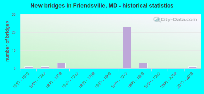
- New bridges - historical statistics
- 11910-1919
- 11920-1929
- 31930-1939
- 231970-1979
- 31980-1989
- 12010-2019

- Reconstructed bridges - Historical Statistics
- 11970-1979
- 01980-1989
- 11990-1999


- Bridge Condition - Deck
- 25.0%Good
- 55.0%Satisfactory
- 10.0%Fair
- 10.0%Poor

- Bridge Condition - Superstructure
- 36.4%Good
- 36.4%Satisfactory
- 9.1%Fair
- 18.2%Poor

- Bridge Condition - Substructure
- 54.5%Good
- 31.8%Satisfactory
- 13.6%Fair

- Bridge Condition - Channel
- 31.3%Very good
- 43.8%Good
- 18.8%Satisfactory
- 6.3%Fair
Find on map >> Show street view
Structure Number: 10000011001001, Location: 1.02 MILES N OF MD 42A (Lat: 39.663408, Lng: -79.450806), Route carried "on" structure: State highway 42, Year Built: 1933, Status: Open, Structure Length: 1.22m (4.00ft), Average Daily Traffic: 2,055 (year 2013), Truck Traffic: 8%, Average Future Daily Traffic: 3,057 (year 2026), Features Intersected: BUFFALO RUN
Minimum Vertical Clearance: 30+ m (98+ ft), Kilometerpoint: 16.450, Lanes on structure: 2, Owner: State Highway Agency, Approaching Roadway Width: 8.8m (28.9ft), Skew: 4 degrees, Material/Design: Concrete, Design/Construction: Arch - Deck, Number Of Spans In Main Unit: 1, Length of Maximum Span: 12.2m (40.0ft), Curb-To-Curb Width: 9.1m (29.9ft), Out-to-Out Width: 10.3m (33.8ft)
Condition: Deck: Fair, Superstructure: Fair, Substructure: Fair, Channel: Good, Structural Evaluation: Somewhat better than minimum adequacy, Deck Geometry: Meets minimum limits, Waterway Adequacy: Superior to present desirable criteria, Approach Roadway Alignment: Equal to present minimum criteria, Designated Inspection Frequency: Every 24 months, Inspection Date: April 2021, Deck Structure Type: Concrete Cast-file-Place, Wearing Surface/Protective System: Wearing Surface: Bituminous
Find on map >> Show street view
Structure Number: 10000011001101, Location: 0.48 MILE NORTH OF MD 42 (Lat: 39.663978, Lng: -79.406953), Route carried "on" structure: State highway 742, Year Built: 1932, Status: Open, Structure Length: 4.91m (16.11ft), Average Daily Traffic: 1,100 (year 2009), Truck Traffic: 8%, Average Future Daily Traffic: 1,211 (year 2026), Design Load: H 20, Features Intersected: YOUGHIOGHENY RIVER
Minimum Vertical Clearance: 30+ m (98+ ft), Kilometerpoint: 0.772, Lanes on structure: 2, Owner: State Highway Agency, Approaching Roadway Width: 9.1m (29.9ft), Material/Design: Steel, Design/Construction: Stringer/Multi-beam, Number Of Spans In Main Unit: 3, Length of Maximum Span: 16.2m (53.1ft), Curb or Sidewalk Widths: Left: 1.5m (4.9ft), Right: 0.0m, Curb-To-Curb Width: 9.1m (29.9ft), Out-to-Out Width: 11.7m (38.4ft)
Condition: Deck: Satisfactory, Superstructure: Satisfactory, Substructure: Good, Channel: Good, Operating Rating: 43.1 metric tons, Method Used To Determine Operating Rating: Load Factor (LF), Inventory Rating: 25.8 metric tons, Method Used To Determine Inventory Rating: Load Factor (LF), Structural Evaluation: Equal to present minimum criteria, Deck Geometry: Somewhat better than minimum adequacy, Waterway Adequacy: Superior to present desirable criteria, Approach Roadway Alignment: Equal to present desirable criteria, Designated Inspection Frequency: Every 24 months, Underwater Inspection Frequency: Every 48 months, Inspection Date: May 2020, Underwater Inspection Date: May 2020, Deck Structure Type: Concrete Cast-file-Place, Wearing Surface/Protective System: Wearing Surface: Bituminous
Find on map >> Show street view
Structure Number: 100000110015013, Location: 0.12 MILE WEST OF MD 742 (Lat: 39.661036, Lng: -79.408592), Route carried "on" structure: Interstate 68, Year Built: 1974, Status: Open, Structure Length: 15.33m (50.30ft), Average Daily Traffic: 12,240 (year 2009), Truck Traffic: 8%, Average Future Daily Traffic: 6,896 (year 2026), Design Load: HS 20, Features Intersected: WATER ST, YOUGHIOGHENY R
Minimum Vertical Clearance: 30+ m (98+ ft), Kilometerpoint: 6.438, Lanes on structure: 3, Lanes under structure: 2, Base Highway Network: Yes, Owner: State Highway Agency, Approaching Roadway Width: 15.9m (52.2ft), Material/Design: Steel continuous, Design/Construction: Stringer/Multi-beam, Number Of Spans In Main Unit: 5, Length of Maximum Span: 32.6m (107.0ft), Curb-To-Curb Width: 14.5m (47.6ft), Out-to-Out Width: 15.5m (50.9ft)
Condition: Deck: Satisfactory, Superstructure: Satisfactory, Substructure: Good, Channel: Very good, Operating Rating: 75.7 metric tons, Method Used To Determine Operating Rating: Load Factor (LF), Inventory Rating: 45.4 metric tons, Method Used To Determine Inventory Rating: Load Factor (LF), Structural Evaluation: Equal to present minimum criteria, Deck Geometry: Meets minimum limits, Underclear: Superior to present desirable criteria, Waterway Adequacy: Meets minimum limits, Approach Roadway Alignment: Equal to present desirable criteria, Designated Inspection Frequency: Every 24 months, Inspection Date: August 2021, Deck Structure Type: Concrete Cast-file-Place, Wearing Surface/Protective System: Wearing Surface: Monolithic Concrete
Find on map >> Show street view
Structure Number: 100000110015014, Location: 0.12 MILE WEST OF MD 742 (Lat: 39.661039, Lng: -79.407536), Route carried "on" structure: Interstate 68, Year Built: 1973, Year Reconstructed: 1975, Status: Open, Structure Length: 15.33m (50.30ft), Average Daily Traffic: 12,240 (year 2009), Truck Traffic: 8%, Average Future Daily Traffic: 6,896 (year 2026), Design Load: HS 20, Features Intersected: WATER ST, YOUGHIOGHENY R
Minimum Vertical Clearance: 30+ m (98+ ft), Kilometerpoint: 6.438, Lanes on structure: 3, Lanes under structure: 2, Base Highway Network: Yes, Owner: State Highway Agency, Approaching Roadway Width: 15.9m (52.2ft), Material/Design: Steel continuous, Design/Construction: Stringer/Multi-beam, Number Of Spans In Main Unit: 5, Length of Maximum Span: 32.6m (107.0ft), Curb-To-Curb Width: 14.5m (47.6ft), Out-to-Out Width: 15.5m (50.9ft)
Condition: Deck: Satisfactory, Superstructure: Satisfactory, Substructure: Good, Channel: Very good, Operating Rating: 72.6 metric tons, Method Used To Determine Operating Rating: Load Factor (LF), Inventory Rating: 43.5 metric tons, Method Used To Determine Inventory Rating: Load Factor (LF), Structural Evaluation: Equal to present minimum criteria, Deck Geometry: Meets minimum limits, Underclear: Superior to present desirable criteria, Waterway Adequacy: Meets minimum limits, Approach Roadway Alignment: Equal to present desirable criteria, Designated Inspection Frequency: Every 24 months, Inspection Date: August 2021, Deck Structure Type: Concrete Cast-file-Place, Wearing Surface/Protective System: Wearing Surface: Monolithic Concrete
Find on map >> Show street view
Structure Number: 100000110038013, Location: 0.48 MILE EAST OF MD 742 (Lat: 39.661692, Lng: -79.398447), Route carried "on" structure: Interstate 68, Year Built: 1973, Status: Open, Structure Length: 23.01m (75.49ft), Average Daily Traffic: 12,240 (year 2009), Truck Traffic: 8%, Average Future Daily Traffic: 18,440 (year 2029), Design Load: HS 20, Features Intersected: MAPLE ST, BEAR CREEK
Minimum Vertical Clearance: 30+ m (98+ ft), Kilometerpoint: 7.334, Lanes on structure: 2, Lanes under structure: 2, Base Highway Network: Yes, Owner: State Highway Agency, Approaching Roadway Width: 11.6m (38.1ft), Material/Design: Steel continuous, Design/Construction: Stringer/Multi-beam, Number Of Spans In Main Unit: 6, Length of Maximum Span: 38.1m (125.0ft), Curb-To-Curb Width: 12.0m (39.4ft), Out-to-Out Width: 13.0m (42.7ft)
Condition: Deck: Good, Superstructure: Good, Substructure: Satisfactory, Channel: Very good, Operating Rating: 65.8 metric tons, Method Used To Determine Operating Rating: Load Factor (LF), Inventory Rating: 39.5 metric tons, Method Used To Determine Inventory Rating: Load Factor (LF), Structural Evaluation: Equal to present minimum criteria, Deck Geometry: Equal to present minimum criteria, Underclear: Superior to present desirable criteria, Waterway Adequacy: Superior to present desirable criteria, Approach Roadway Alignment: Equal to present desirable criteria, Designated Inspection Frequency: Every 24 months, Inspection Date: August 2021, Deck Structure Type: Concrete Cast-file-Place, Wearing Surface/Protective System: Wearing Surface: Monolithic Concrete
Find on map >> Show street view
Structure Number: 100000110038014, Location: 0.48 MILE EAST OF MD 742 (Lat: 39.662153, Lng: -79.396903), Route carried "on" structure: Interstate 68, Year Built: 1973, Status: Open, Structure Length: 23.01m (75.49ft), Average Daily Traffic: 12,240 (year 2009), Truck Traffic: 8%, Average Future Daily Traffic: 18,440 (year 2029), Design Load: HS 20, Features Intersected: MAPLE ST, BEAR CREEK
Minimum Vertical Clearance: 30+ m (98+ ft), Kilometerpoint: 7.334, Lanes on structure: 2, Lanes under structure: 2, Base Highway Network: Yes, Owner: State Highway Agency, Approaching Roadway Width: 11.6m (38.1ft), Material/Design: Steel continuous, Design/Construction: Stringer/Multi-beam, Number Of Spans In Main Unit: 6, Length of Maximum Span: 38.1m (125.0ft), Curb-To-Curb Width: 12.0m (39.4ft), Out-to-Out Width: 13.0m (42.7ft)
Condition: Deck: Satisfactory, Superstructure: Satisfactory, Substructure: Fair, Channel: Very good, Operating Rating: 65.8 metric tons, Method Used To Determine Operating Rating: Load Factor (LF), Inventory Rating: 39.5 metric tons, Method Used To Determine Inventory Rating: Load Factor (LF), Structural Evaluation: Somewhat better than minimum adequacy, Deck Geometry: Equal to present minimum criteria, Underclear: Superior to present desirable criteria, Waterway Adequacy: Superior to present desirable criteria, Approach Roadway Alignment: Equal to present desirable criteria, Designated Inspection Frequency: Every 24 months, Inspection Date: August 2021, Deck Structure Type: Concrete Cast-file-Place, Wearing Surface/Protective System: Wearing Surface: Monolithic Concrete
Find on map >> Show street view
Structure Number: 100000110039013, Location: 0.33 MILE WEST OF MD 742 (Lat: 39.661703, Lng: -79.412197), Route carried "on" structure: Interstate 68, Year Built: 1974, Status: Open, Structure Length: 5.49m (18.01ft), Average Daily Traffic: 12,240 (year 2009), Truck Traffic: 8%, Average Future Daily Traffic: 6,896 (year 2026), Design Load: HS 20, Features Intersected: MD 42
Minimum Vertical Clearance: 30+ m (98+ ft), Kilometerpoint: 6.132, Lanes on structure: 2, Lanes under structure: 2, Base Highway Network: Yes, Owner: State Highway Agency, Approaching Roadway Width: 12.2m (40.0ft), Skew: 4 degrees, Material/Design: Steel continuous, Design/Construction: Stringer/Multi-beam, Number Of Spans In Main Unit: 3, Length of Maximum Span: 23.5m (77.1ft), Curb-To-Curb Width: 12.0m (39.4ft), Out-to-Out Width: 13.0m (42.7ft)
Condition: Deck: Satisfactory, Superstructure: Good, Substructure: Good, Operating Rating: 76.2 metric tons, Method Used To Determine Operating Rating: Load Factor (LF), Inventory Rating: 45.4 metric tons, Method Used To Determine Inventory Rating: Load Factor (LF), Structural Evaluation: Better than present minimum criteria, Deck Geometry: Equal to present minimum criteria, Underclear: Better than present minimum criteria, Approach Roadway Alignment: Equal to present desirable criteria, Designated Inspection Frequency: Every 24 months, Inspection Date: April 2021, Deck Structure Type: Concrete Cast-file-Place, Wearing Surface/Protective System: Wearing Surface: Monolithic Concrete
Find on map >> Show street view
Structure Number: 100000110039014, Location: 0.33 MILE WEST OF MD 742 (Lat: 39.661939, Lng: -79.412400), Route carried "on" structure: Interstate 68, Year Built: 1974, Status: Open, Structure Length: 6.16m (20.21ft), Average Daily Traffic: 12,240 (year 2009), Truck Traffic: 8%, Average Future Daily Traffic: 6,896 (year 2026), Design Load: HS 20, Features Intersected: MD 42
Minimum Vertical Clearance: 30+ m (98+ ft), Kilometerpoint: 6.132, Lanes on structure: 2, Lanes under structure: 2, Base Highway Network: Yes, Owner: State Highway Agency, Approaching Roadway Width: 12.2m (40.0ft), Skew: 4 degrees, Material/Design: Steel continuous, Design/Construction: Stringer/Multi-beam, Number Of Spans In Main Unit: 3, Length of Maximum Span: 26.2m (86.0ft), Curb-To-Curb Width: 12.0m (39.4ft), Out-to-Out Width: 13.0m (42.7ft)
Condition: Deck: Satisfactory, Superstructure: Satisfactory, Substructure: Good, Operating Rating: 79.8 metric tons, Method Used To Determine Operating Rating: Load Factor (LF), Inventory Rating: 48.1 metric tons, Method Used To Determine Inventory Rating: Load Factor (LF), Structural Evaluation: Equal to present minimum criteria, Deck Geometry: Equal to present minimum criteria, Underclear: Superior to present desirable criteria, Approach Roadway Alignment: Equal to present desirable criteria, Designated Inspection Frequency: Every 24 months, Inspection Date: April 2021, Deck Structure Type: Concrete Cast-file-Place, Wearing Surface/Protective System: Wearing Surface: Monolithic Concrete
Find on map >> Show street view
Structure Number: 100000110040013, Location: 0.33 MILE EAST OF MD 42 (Lat: 39.660636, Lng: -79.406011), Route carried "on" structure: Interstate 68, Year Built: 1974, Status: Open, Structure Length: 4.30m (14.11ft), Average Daily Traffic: 12,240 (year 2009), Truck Traffic: 8%, Average Future Daily Traffic: 18,440 (year 2029), Design Load: HS 20, Features Intersected: MD 742
Minimum Vertical Clearance: 30+ m (98+ ft), Kilometerpoint: 6.669, Lanes on structure: 3, Lanes under structure: 2, Base Highway Network: Yes, Owner: State Highway Agency, Approaching Roadway Width: 14.6m (47.9ft), Material/Design: Steel continuous, Design/Construction: Stringer/Multi-beam, Number Of Spans In Main Unit: 3, Length of Maximum Span: 18.3m (60.0ft), Curb-To-Curb Width: 14.5m (47.6ft), Out-to-Out Width: 15.5m (50.9ft)
Condition: Deck: Satisfactory, Superstructure: Good, Substructure: Good, Inventory Rating: 64.4 metric tons, Method Used To Determine Inventory Rating: Load Factor (LF), Structural Evaluation: Better than present minimum criteria, Deck Geometry: Meets minimum limits, Underclear: Somewhat better than minimum adequacy, Approach Roadway Alignment: Equal to present desirable criteria, Designated Inspection Frequency: Every 24 months, Inspection Date: April 2021, Deck Structure Type: Concrete Cast-file-Place, Wearing Surface/Protective System: Wearing Surface: Monolithic Concrete
Find on map >> Show street view
Structure Number: 100000110040014, Location: 0.33 MILE EAST OF MD 42 (Lat: 39.660842, Lng: -79.406161), Route carried "on" structure: Interstate 68, Year Built: 1974, Status: Open, Structure Length: 4.54m (14.90ft), Average Daily Traffic: 12,240 (year 2009), Truck Traffic: 8%, Average Future Daily Traffic: 18,440 (year 2029), Design Load: HS 20, Features Intersected: MD 742
Minimum Vertical Clearance: 30+ m (98+ ft), Kilometerpoint: 6.669, Lanes on structure: 2, Lanes under structure: 2, Base Highway Network: Yes, Owner: State Highway Agency, Approaching Roadway Width: 12.2m (40.0ft), Material/Design: Steel continuous, Design/Construction: Stringer/Multi-beam, Number Of Spans In Main Unit: 3, Length of Maximum Span: 18.3m (60.0ft), Curb-To-Curb Width: 12.0m (39.4ft), Out-to-Out Width: 13.0m (42.7ft)
Condition: Deck: Good, Superstructure: Good, Substructure: Good, Inventory Rating: 66.7 metric tons, Method Used To Determine Inventory Rating: Load Factor (LF), Structural Evaluation: Better than present minimum criteria, Deck Geometry: Equal to present minimum criteria, Underclear: Somewhat better than minimum adequacy, Approach Roadway Alignment: Equal to present desirable criteria, Designated Inspection Frequency: Every 24 months, Inspection Date: April 2021, Deck Structure Type: Concrete Cast-file-Place, Wearing Surface/Protective System: Wearing Surface: Monolithic Concrete
Find on map >> Show street view
Structure Number: 10000011004201, Location: 0.22 MI S OF MD 42 (Lat: 39.654028, Lng: -79.439189), Route carried "on" structure: County highway 355, Year Built: 1975, Status: Open, Structure Length: 11.67m (38.29ft), Average Daily Traffic: 2,113 (year 2010), Truck Traffic: 5%, Average Future Daily Traffic: 2,614 (year 2026), Design Load: HS 20, Features Intersected: IS 68, Facility Carried by Structure: BLOOMING ROSE ROAD
Minimum Vertical Clearance: 30+ m (98+ ft), Kilometerpoint: 1.464, Lanes on structure: 2, Lanes under structure: 5, Owner: State Highway Agency, Approaching Roadway Width: 10.4m (34.1ft), Material/Design: Steel continuous, Design/Construction: Stringer/Multi-beam, Number Of Spans In Main Unit: 3, Length of Maximum Span: 48.8m (160.1ft), Curb-To-Curb Width: 10.4m (34.1ft), Out-to-Out Width: 11.3m (37.1ft)
Condition: Deck: Good, Superstructure: Good, Substructure: Satisfactory, Operating Rating: 43.5 metric tons, Method Used To Determine Operating Rating: Allowable Stress (AS), Inventory Rating: 26.3 metric tons, Method Used To Determine Inventory Rating: Allowable Stress (AS), Structural Evaluation: Equal to present minimum criteria, Deck Geometry: Somewhat better than minimum adequacy, Underclear: Better than present minimum criteria, Approach Roadway Alignment: Equal to present desirable criteria, Designated Inspection Frequency: Every 24 months, Critical Feature Inspection Frequency: Every 24 months, Inspection Date: July 2021, Critical Feature Inspection Date: July 2021, Deck Structure Type: Concrete Cast-file-Place, Wearing Surface/Protective System: Wearing Surface: Monolithic Concrete
Find on map >> Show street view
Structure Number: 10000011004502, Location: 1.27 MILES E OF W VA (Lat: 39.658106, Lng: -79.453897), Route carried "on" structure: Interstate 68, Year Built: 1975, Status: Open, Structure Length: 1.33m (4.36ft), Average Daily Traffic: 14,341 (year 2013), Truck Traffic: 8%, Average Future Daily Traffic: 24,630 (year 2029), Design Load: HS 20, Features Intersected: BUFFALO RUN
Minimum Vertical Clearance: 30+ m (98+ ft), Kilometerpoint: 2.055, Lanes on structure: 4, Base Highway Network: Yes, Owner: State Highway Agency, Approaching Roadway Width: 31.7m (104.0ft), Skew: 4 degrees, Material/Design: Concrete, Design/Construction: Culvert, Length of Maximum Span: 6.4m (21.0ft)
Condition: Channel: Satisfactory, Culverts: Satisfactory, Operating Rating: 88.9 metric tons, Method Used To Determine Operating Rating: Load Factor (LF), Inventory Rating: 53.1 metric tons, Method Used To Determine Inventory Rating: Load Factor (LF), Structural Evaluation: Equal to present minimum criteria, Waterway Adequacy: Equal to present desirable criteria, Approach Roadway Alignment: Equal to present desirable criteria, Designated Inspection Frequency: Every 24 months, Inspection Date: August 2021
Find on map >> Show street view
Structure Number: 100000110046013, Location: 0.66 MILE EAST OF W VA (Lat: 39.661136, Lng: -79.465203), Route carried "on" structure: Interstate 68, Year Built: 1975, Status: Open, Structure Length: 6.07m (19.91ft), Average Daily Traffic: 15,710 (year 2009), Truck Traffic: 8%, Average Future Daily Traffic: 24,630 (year 2029), Design Load: HS 20, Features Intersected: SAND SPRING RD
Minimum Vertical Clearance: 30+ m (98+ ft), Kilometerpoint: 1.030, Lanes on structure: 2, Lanes under structure: 2, Base Highway Network: Yes, Owner: State Highway Agency, Approaching Roadway Width: 11.6m (38.1ft), Skew: 2 degrees, Material/Design: Steel continuous, Design/Construction: Stringer/Multi-beam, Number Of Spans In Main Unit: 3, Length of Maximum Span: 19.8m (65.0ft), Curb-To-Curb Width: 12.0m (39.4ft), Out-to-Out Width: 13.0m (42.7ft)
Condition: Deck: Satisfactory, Superstructure: Good, Substructure: Good, Operating Rating: 73.0 metric tons, Method Used To Determine Operating Rating: Load Factor (LF), Inventory Rating: 43.5 metric tons, Method Used To Determine Inventory Rating: Load Factor (LF), Structural Evaluation: Better than present minimum criteria, Deck Geometry: Equal to present minimum criteria, Underclear: Equal to present desirable criteria, Approach Roadway Alignment: Equal to present desirable criteria, Designated Inspection Frequency: Every 24 months, Inspection Date: August 2020, Deck Structure Type: Concrete Cast-file-Place, Wearing Surface/Protective System: Wearing Surface: Monolithic Concrete
Find on map >> Show street view
Structure Number: 100000110046014, Location: 0.66 MILE EAST OF W VA (Lat: 39.661217, Lng: -79.464761), Route carried "on" structure: Interstate 68, Year Built: 1975, Status: Open, Structure Length: 5.09m (16.70ft), Average Daily Traffic: 15,710 (year 2009), Truck Traffic: 8%, Average Future Daily Traffic: 24,630 (year 2029), Design Load: HS 20, Features Intersected: SAND SPRING RD
Minimum Vertical Clearance: 30+ m (98+ ft), Kilometerpoint: 1.030, Lanes on structure: 3, Lanes under structure: 2, Base Highway Network: Yes, Owner: State Highway Agency, Approaching Roadway Width: 15.2m (49.9ft), Skew: 2 degrees, Material/Design: Steel continuous, Design/Construction: Stringer/Multi-beam, Number Of Spans In Main Unit: 3, Length of Maximum Span: 19.8m (65.0ft), Curb-To-Curb Width: 15.7m (51.5ft), Out-to-Out Width: 16.7m (54.8ft)
Condition: Deck: Satisfactory, Superstructure: Good, Substructure: Good, Operating Rating: 74.8 metric tons, Method Used To Determine Operating Rating: Load Factor (LF), Inventory Rating: 44.9 metric tons, Method Used To Determine Inventory Rating: Load Factor (LF), Structural Evaluation: Better than present minimum criteria, Deck Geometry: Somewhat better than minimum adequacy, Underclear: Equal to present desirable criteria, Approach Roadway Alignment: Equal to present desirable criteria, Designated Inspection Frequency: Every 24 months, Inspection Date: August 2020, Deck Structure Type: Concrete Cast-file-Place, Wearing Surface/Protective System: Wearing Surface: Monolithic Concrete
Find on map >> Show street view
Structure Number: 10000011005401, Location: 0.11 MILE NORTH OF MD 742 (Lat: 39.659172, Lng: -79.409886), Route carried "on" structure: State highway 42, Year Built: 1976, Status: Open, Structure Length: 17.25m (56.59ft), Average Daily Traffic: 2,791 (year 2009), Truck Traffic: 8%, Average Future Daily Traffic: 3,737 (year 2026), Design Load: HS 20, Features Intersected: YOUGHIOGHENY RIVER
Minimum Vertical Clearance: 30+ m (98+ ft), Kilometerpoint: 11.874, Lanes on structure: 2, Lanes under structure: 2, Base Highway Network: Yes, Owner: State Highway Agency, Approaching Roadway Width: 13.4m (44.0ft), Skew: 1 degrees, Material/Design: Steel continuous, Design/Construction: Stringer/Multi-beam, Number Of Spans In Main Unit: 4, Length of Maximum Span: 51.8m (169.9ft), Curb-To-Curb Width: 13.4m (44.0ft), Out-to-Out Width: 14.4m (47.2ft)
Condition: Deck: Fair, Superstructure: Satisfactory, Substructure: Good, Channel: Very good, Operating Rating: 44.9 metric tons, Method Used To Determine Operating Rating: Load Factor (LF), Inventory Rating: 26.8 metric tons, Method Used To Determine Inventory Rating: Load Factor (LF), Structural Evaluation: Equal to present minimum criteria, Deck Geometry: Better than present minimum criteria, Underclear: Superior to present desirable criteria, Waterway Adequacy: Equal to present desirable criteria, Approach Roadway Alignment: Equal to present desirable criteria, Designated Inspection Frequency: Every 24 months, Inspection Date: August 2021, Deck Structure Type: Concrete Cast-file-Place, Wearing Surface/Protective System: Wearing Surface: Monolithic Concrete
Find on map >> Show street view
Structure Number: 200000G-007201, Location: 0.2 MI NE OF MD RTE 42 (Lat: 39.690517, Lng: -79.438689), Route carried "on" structure: County highway 9, Year Built: 1989, Status: Posted for load, Structure Length: 1.10m (3.61ft), Average Daily Traffic: 48 (year 2021), Truck Traffic: 5%, Average Future Daily Traffic: 59 (year 2041), Design Load: HS 20, Features Intersected: BUFFALO RUN, Facility Carried by Structure: BUFFALO RUN ROAD
Minimum Vertical Clearance: 30+ m (98+ ft), Kilometerpoint: 4.827, Lanes on structure: 2, Owner: County Highway Agency, Approaching Roadway Width: 8.5m (27.9ft), Material/Design: Wood or Timber, Design/Construction: Slab, Number Of Spans In Main Unit: 1, Length of Maximum Span: 10.4m (34.1ft), Curb or Sidewalk Widths: Left: 0.2m (0.7ft), Right: 0.2m (0.7ft), Curb-To-Curb Width: 6.2m (20.3ft), Out-to-Out Width: 6.6m (21.7ft)
Condition: Deck: Poor, Superstructure: Poor, Substructure: Satisfactory, Channel: Satisfactory, Operating Rating: 20.0 metric tons, Method Used To Determine Operating Rating: Load Factor (LF), Inventory Rating: 14.1 metric tons, Method Used To Determine Inventory Rating: Load Factor (LF), Structural Evaluation: Meets minimum limits, Deck Geometry: Somewhat better than minimum adequacy, Waterway Adequacy: Better than present minimum criteria, Approach Roadway Alignment: Equal to present minimum criteria, Bridge Posting: Required (Relationship of Operating Rating to Maximum Legal Load: > 39.9% below), Length Of Structure Improvement: 1.10m (3.61ft), Designated Inspection Frequency: Every 12 months, Inspection Date: September 2021, Bridge Improvement Cost: $210,000, Roadway Improvement Cost: $14,000, Total Project Cost: $224,000, Deck Structure Type: Wood or Timber, Wearing Surface/Protective System: Wearing Surface: Bituminous
Find on map >> Show street view
Structure Number: 200000G-007301, Location: 0.37 MI NE OF MD RTE 42 (Lat: 39.692200, Lng: -79.437275), Route carried "on" structure: County highway 9, Year Built: 1989, Status: Posted for load, Structure Length: 1.01m (3.31ft), Average Daily Traffic: 44 (year 2021), Truck Traffic: 5%, Average Future Daily Traffic: 53 (year 2041), Features Intersected: BUFFALO RUN, Facility Carried by Structure: BUFFALO RUN ROAD
Minimum Vertical Clearance: 30+ m (98+ ft), Kilometerpoint: 0.595, Lanes on structure: 2, Owner: County Highway Agency, Approaching Roadway Width: 8.5m (27.9ft), Material/Design: Wood or Timber, Design/Construction: Slab, Number Of Spans In Main Unit: 1, Length of Maximum Span: 9.1m (29.9ft), Curb-To-Curb Width: 5.8m (19.0ft), Out-to-Out Width: 6.2m (20.3ft)
Condition: Deck: Poor, Superstructure: Poor, Substructure: Satisfactory, Channel: Fair, Operating Rating: 26.3 metric tons, Method Used To Determine Operating Rating: Load Factor (LF), Inventory Rating: 18.6 metric tons, Method Used To Determine Inventory Rating: Load Factor (LF), Structural Evaluation: Meets minimum limits, Deck Geometry: Meets minimum limits, Waterway Adequacy: Equal to present desirable criteria, Approach Roadway Alignment: High priority of corrective action, Bridge Posting: Required (Relationship of Operating Rating to Maximum Legal Load: > 39.9% below), Length Of Structure Improvement: 1.07m (3.51ft), Designated Inspection Frequency: Every 12 months, Inspection Date: September 2021, Bridge Improvement Cost: $210,000, Roadway Improvement Cost: $14,000, Total Project Cost: $224,000, Deck Structure Type: Wood or Timber, Wearing Surface/Protective System: Wearing Surface: Bituminous
Find on map >> Show street view
Structure Number: 200000G-007401, Location: 1.33 MI E OF MD RTE 42 (Lat: 39.688794, Lng: -79.421389), Route carried "on" structure: County highway 9, Year Built: 1982, Status: Posted for load, Structure Length: 1.52m (4.99ft), Average Daily Traffic: 40 (year 2019), Truck Traffic: 5%, Average Future Daily Traffic: 50 (year 2039), Features Intersected: BUFFALO RUN, Facility Carried by Structure: BUFFALO RUN ROAD
Minimum Vertical Clearance: 30+ m (98+ ft), Kilometerpoint: 2.140, Lanes on structure: 2, Owner: County Highway Agency, Approaching Roadway Width: 4.9m (16.1ft), Material/Design: Steel, Design/Construction: Stringer/Multi-beam, Number Of Spans In Main Unit: 1, Length of Maximum Span: 14.6m (47.9ft), Curb-To-Curb Width: 5.8m (19.0ft), Out-to-Out Width: 6.1m (20.0ft)
Condition: Deck: Satisfactory, Superstructure: Fair, Substructure: Good, Channel: Good, Operating Rating: 51.2 metric tons, Method Used To Determine Operating Rating: Load Factor (LF), Inventory Rating: 30.8 metric tons, Method Used To Determine Inventory Rating: Load Factor (LF), Structural Evaluation: Somewhat better than minimum adequacy, Deck Geometry: Meets minimum limits, Waterway Adequacy: Equal to present desirable criteria, Approach Roadway Alignment: High priority of corrective action, Length Of Structure Improvement: 1.52m (4.99ft), Designated Inspection Frequency: Every 24 months, Inspection Date: September 2021, Bridge Improvement Cost: $17,000, Total Project Cost: $17,000, Deck Structure Type: Concrete Cast-file-Place, Wearing Surface/Protective System: Wearing Surface: Bituminous
Find on map >> Show street view
Structure Number: 200000G-007501, Location: .5 MI NW OLD GOOD HOPE RD (Lat: 39.676403, Lng: -79.444581), Route carried "on" structure: County highway 354, Year Built: 1935, Year Reconstructed: 1997, Status: Posted for load, Structure Length: 0.94m (3.08ft), Average Daily Traffic: 133 (year 2021), Truck Traffic: 5%, Average Future Daily Traffic: 165 (year 2041), Design Load: HS 20, Features Intersected: BUFFALO RUN, Facility Carried by Structure: HUMBERSON ROAD
Minimum Vertical Clearance: 30+ m (98+ ft), Kilometerpoint: 0.000, Lanes on structure: 1, Owner: County Highway Agency, Approaching Roadway Width: 4.6m (15.1ft), Material/Design: Steel, Design/Construction: Stringer/Multi-beam, Number Of Spans In Main Unit: 1, Length of Maximum Span: 8.5m (27.9ft), Curb-To-Curb Width: 4.6m (15.1ft), Out-to-Out Width: 4.7m (15.4ft)
Condition: Deck: Good, Superstructure: Satisfactory, Substructure: Satisfactory, Channel: Good, Operating Rating: 61.7 metric tons, Method Used To Determine Operating Rating: Load Factor (LF), Inventory Rating: 36.7 metric tons, Method Used To Determine Inventory Rating: Load Factor (LF), Structural Evaluation: Equal to present minimum criteria, Deck Geometry: High priority of replacement, Waterway Adequacy: Better than present minimum criteria, Approach Roadway Alignment: Equal to present minimum criteria, Designated Inspection Frequency: Every 24 months, Inspection Date: September 2021, Bridge Improvement Cost: $20,000, Total Project Cost: $20,000, Deck Structure Type: Corrugated Steel, Wearing Surface/Protective System: Wearing Surface: Bituminous
Find on map >> Show street view
Structure Number: 200000G-007601, Location: 0.26 MI E OF MD RTE 42 (Lat: 39.366678, Lng: -79.451767), Route carried "on" structure: County highway 352, Year Built: 1919, Status: Open, Structure Length: 0.91m (2.99ft), Average Daily Traffic: 122 (year 2021), Truck Traffic: 5%, Average Future Daily Traffic: 150 (year 2041), Features Intersected: BUFFALO RUN, Facility Carried by Structure: OLD MORGANTOWN ROA
Minimum Vertical Clearance: 30+ m (98+ ft), Kilometerpoint: 0.418, Lanes on structure: 1, Owner: County Highway Agency, Approaching Roadway Width: 4.9m (16.1ft), Material/Design: Concrete, Design/Construction: Arch - Deck, Number Of Spans In Main Unit: 1, Length of Maximum Span: 9.1m (29.9ft), Curb-To-Curb Width: 4.8m (15.7ft), Out-to-Out Width: 5.2m (17.1ft)
Condition: Superstructure: Poor, Substructure: Fair, Channel: Satisfactory, Operating Rating: 32.7 metric tons, Method Used To Determine Operating Rating: Field evaluation and documented engineering judgment, Inventory Rating: 32.7 metric tons, Method Used To Determine Inventory Rating: Field evaluation and documented engineering judgment, Structural Evaluation: Meets minimum limits, Deck Geometry: High priority of corrective action, Waterway Adequacy: Equal to present minimum criteria, Approach Roadway Alignment: Meets minimum limits, Length Of Structure Improvement: 4.57m (14.99ft), Designated Inspection Frequency: Every 24 months, Inspection Date: September 2021, Bridge Improvement Cost: $193,000, Roadway Improvement Cost: $20,000, Total Project Cost: $213,000, Wearing Surface/Protective System: Wearing Surface: Bituminous
Find on map >> Show street view
Structure Number: 200000G-007701, Location: 0.01 MI N OF WALNUT ST (Lat: 39.664056, Lng: -79.401500), Route carried "on" structure: County highway 34, Year Built: 1920, Status: Posted for load, Structure Length: 1.89m (6.20ft), Average Daily Traffic: 30 (year 2021), Truck Traffic: 5%, Average Future Daily Traffic: 40 (year 2041), Features Intersected: BEAR CREEK, Facility Carried by Structure: OLD SELBYSPORT RD
Minimum Vertical Clearance: 30+ m (98+ ft), Kilometerpoint: 0.016, Lanes on structure: 1, Owner: County Highway Agency, Approaching Roadway Width: 3.7m (12.1ft), Material/Design: Concrete, Design/Construction: Arch - Deck, Number Of Spans In Main Unit: 1, Length of Maximum Span: 18.9m (62.0ft), Curb-To-Curb Width: 3.8m (12.5ft), Out-to-Out Width: 4.7m (15.4ft)
Condition: Superstructure: Poor, Substructure: Satisfactory, Channel: Good, Operating Rating: 4.5 metric tons, Method Used To Determine Operating Rating: Field evaluation and documented engineering judgment, Inventory Rating: 4.5 metric tons, Method Used To Determine Inventory Rating: Field evaluation and documented engineering judgment, Structural Evaluation: High priority of replacement, Deck Geometry: Meets minimum limits, Waterway Adequacy: Equal to present minimum criteria, Approach Roadway Alignment: High priority of corrective action, Bridge Posting: Required (Relationship of Operating Rating to Maximum Legal Load: > 39.9% below), Length Of Structure Improvement: 5.49m (18.01ft), Designated Inspection Frequency: Every 12 months, Inspection Date: September 2021, Bridge Improvement Cost: $369,000, Roadway Improvement Cost: $30,000, Total Project Cost: $399,000, Deck Structure Type: Other, Wearing Surface/Protective System: Wearing Surface: Bituminous
Find on map >> Show street view
Structure Number: 200000G-007801, Location: 0.04 MI NE OF PARK AVE (Lat: 39.665444, Lng: -79.419389), Route carried "on" structure: County highway 356, Year Built: 1979, Status: Posted for load, Structure Length: 1.55m (5.09ft), Average Daily Traffic: 1,055 (year 2021), Truck Traffic: 5%, Average Future Daily Traffic: 1,290 (year 2041), Features Intersected: BEAR CREEK, Facility Carried by Structure: FRIENDSVILLE ADDIS
Minimum Vertical Clearance: 8.23m (27.00ft), Kilometerpoint: 0.016, Lanes on structure: 2, Owner: County Highway Agency, Approaching Roadway Width: 8.5m (27.9ft), Material/Design: Prestressed concrete, Design/Construction: Box Beam or Girders - Multiple, Number Of Spans In Main Unit: 1, Length of Maximum Span: 14.6m (47.9ft), Curb-To-Curb Width: 8.7m (28.5ft), Out-to-Out Width: 9.2m (30.2ft)
Condition: Deck: Satisfactory, Superstructure: Satisfactory, Substructure: Satisfactory, Channel: Good, Operating Rating: 32.7 metric tons, Method Used To Determine Operating Rating: Field evaluation and documented engineering judgment, Inventory Rating: 32.7 metric tons, Method Used To Determine Inventory Rating: Field evaluation and documented engineering judgment, Structural Evaluation: Equal to present minimum criteria, Deck Geometry: Somewhat better than minimum adequacy, Waterway Adequacy: Better than present minimum criteria, Approach Roadway Alignment: Equal to present minimum criteria, Length Of Structure Improvement: 3.05m (10.01ft), Designated Inspection Frequency: Every 24 months, Inspection Date: September 2021, Bridge Improvement Cost: $11,000, Total Project Cost: $11,000, Wearing Surface/Protective System: Wearing Surface: Bituminous
Find on map >> Show street view
Structure Number: 200000G-008401, Location: 0.01 MI S MILL RUN RD (Lat: 39.710481, Lng: -79.370053), Route carried "on" structure: County highway 29, Year Built: 2015, Status: Open, Structure Length: 1.65m (5.41ft), Average Daily Traffic: 138 (year 2021), Truck Traffic: 5%, Average Future Daily Traffic: 168 (year 2041), Design Load: HS 20, Features Intersected: MILL RUN, Facility Carried by Structure: CHET KELLY ROAD
Minimum Vertical Clearance: 30+ m (98+ ft), Kilometerpoint: 0.016, Lanes on structure: 1, Owner: County Highway Agency, Approaching Roadway Width: 4.3m (14.1ft), Material/Design: Steel, Design/Construction: Stringer/Multi-beam, Number Of Spans In Main Unit: 1, Length of Maximum Span: 16.5m (54.1ft), Curb-To-Curb Width: 4.3m (14.1ft), Out-to-Out Width: 4.3m (14.1ft)
Condition: Deck: Good, Superstructure: Good, Substructure: Good, Channel: Good, Operating Rating: 36.6 metric tons, Method Used To Determine Operating Rating: Load and Resistance Factor Rating (LRFR) rating reported by rating factor(RF) method using HL-93 loadings, Inventory Rating: 28.2 metric tons, Method Used To Determine Inventory Rating: Load and Resistance Factor Rating (LRFR) rating reported by rating factor(RF) method using HL-93 loadings, Structural Evaluation: Better than present minimum criteria, Deck Geometry: High priority of replacement, Waterway Adequacy: Better than present minimum criteria, Approach Roadway Alignment: Equal to present minimum criteria, Designated Inspection Frequency: Every 24 months, Inspection Date: September 2021, Deck Structure Type: Corrugated Steel, Wearing Surface/Protective System: Wearing Surface: Bituminous
Find on map >> Show street view
Structure Number: 100000110015013, Location: 0.11 MI W OF MD 742 (Lat: 39.661036, Lng: -79.408592), Route carried "under" structure: City street 110, Year Built: 1974, Structure Length: 0. m, Features Intersected: WATER ST,YOUGHIOGHENY RI, Facility Carried by Structure: IS 68 EBR
Minimum Vertical Clearance: 5.49m (18.01ft), Kilometerpoint: 0.370, Lanes on structure: 3, Lanes under structure: 2, Material/Design: Steel continuous, Design/Construction: Stringer/Multi-beam, Length of Maximum Span: 32.6m (107.0ft)
Find on map >> Show street view
Structure Number: 100000110015014, Location: 0.11 MI W OF MD 742 (Lat: 39.661039, Lng: -79.407536), Route carried "under" structure: City street 110, Year Built: 1973, Structure Length: 0. m, Features Intersected: WATER ST,YOUGHIOGHENY RI, Facility Carried by Structure: IS 68 WBR
Minimum Vertical Clearance: 5.49m (18.01ft), Kilometerpoint: 0.338, Lanes on structure: 3, Lanes under structure: 2, Material/Design: Steel continuous, Design/Construction: Stringer/Multi-beam, Length of Maximum Span: 32.6m (107.0ft)
Find on map >> Show street view
Structure Number: 100000110038013, Location: 0.46 MI E OF MD 742 (Lat: 39.661692, Lng: -79.398447), Route carried "under" structure: County highway 446, Year Built: 1973, Structure Length: 0. m, Average Daily Traffic: 2,074 (year 2009), Features Intersected: MAPLE ST, BEAR CREEK, Facility Carried by Structure: IS 68 EBR
Minimum Vertical Clearance: 5.49m (18.01ft), Kilometerpoint: 0.756, Lanes on structure: 2, Lanes under structure: 2, Material/Design: Steel continuous, Design/Construction: Stringer/Multi-beam, Length of Maximum Span: 38.1m (125.0ft)
Find on map >> Show street view
Structure Number: 100000110038014, Location: 0.46 MI E OF MD 742 (Lat: 39.662153, Lng: -79.396903), Route carried "under" structure: County highway 446, Year Built: 1973, Structure Length: 0. m, Average Daily Traffic: 2,074 (year 2009), Features Intersected: MAPLE ST, BEAR CREEK, Facility Carried by Structure: IS 68 WBR
Minimum Vertical Clearance: 5.49m (18.01ft), Kilometerpoint: 0.756, Lanes on structure: 2, Lanes under structure: 2, Material/Design: Steel continuous, Design/Construction: Stringer/Multi-beam, Length of Maximum Span: 38.1m (125.0ft)
Find on map >> Show street view
Structure Number: 100000110039013, Location: 0.4 MILE NORTH OF MD 742 (Lat: 39.661703, Lng: -79.412197), Route carried "under" structure: State highway 42, Year Built: 1974, Structure Length: 0. m, Average Daily Traffic: 2,071 (year 2009), Features Intersected: MD 42, Facility Carried by Structure: IS 68 EBR
Minimum Vertical Clearance: 5.49m (18.01ft), Kilometerpoint: 12.341, Lanes on structure: 2, Lanes under structure: 2, Material/Design: Steel continuous, Design/Construction: Stringer/Multi-beam, Length of Maximum Span: 23.5m (77.1ft)
Find on map >> Show street view
Structure Number: 100000110039014, Location: 0.4 MILE NORTH OF MD 742 (Lat: 39.661939, Lng: -79.412400), Route carried "under" structure: State highway 42, Year Built: 1974, Structure Length: 0. m, Average Daily Traffic: 2,071 (year 2009), Features Intersected: MD 42, Facility Carried by Structure: IS 68 WBR
Minimum Vertical Clearance: 5.49m (18.01ft), Kilometerpoint: 12.341, Lanes on structure: 2, Lanes under structure: 2, Material/Design: Steel continuous, Design/Construction: Stringer/Multi-beam, Length of Maximum Span: 26.2m (86.0ft)
Find on map >> Show street view
Structure Number: 100000110040013, Location: 0.17 MILE NORTH OF MD 42 (Lat: 39.660636, Lng: -79.406011), Route carried "under" structure: State highway 742, Year Built: 1974, Structure Length: 0. m, Average Daily Traffic: 1,100 (year 2009), Features Intersected: MD 742, Facility Carried by Structure: IS 68 EBR
Minimum Vertical Clearance: 5.49m (18.01ft), Kilometerpoint: 0.274, Lanes on structure: 3, Lanes under structure: 2, Material/Design: Steel continuous, Design/Construction: Stringer/Multi-beam, Length of Maximum Span: 18.3m (60.0ft)
Find on map >> Show street view
Structure Number: 100000110040014, Location: 0.17 MILE NORTH OF MD 42 (Lat: 39.660842, Lng: -79.406161), Route carried "under" structure: State highway 742, Year Built: 1974, Structure Length: 0. m, Average Daily Traffic: 1,100 (year 2009), Features Intersected: MD 742, Facility Carried by Structure: IS 68 WBR
Minimum Vertical Clearance: 5.49m (18.01ft), Kilometerpoint: 0.274, Lanes on structure: 2, Lanes under structure: 2, Material/Design: Steel continuous, Design/Construction: Stringer/Multi-beam, Length of Maximum Span: 18.3m (60.0ft)
Find on map >> Show street view
Structure Number: 10000011004201, Location: 1.66 MILES WEST OF MD 42 (Lat: 39.654028, Lng: -79.439189), Route carried "under" structure: Interstate 68, Year Built: 1975, Structure Length: 0. m, Average Daily Traffic: 15,710 (year 2009), Features Intersected: IS 68, Facility Carried by Structure: BLOOMING ROSE ROAD
Minimum Vertical Clearance: 5.49m (18.01ft), Kilometerpoint: 3.492, Lanes on structure: 2, Lanes under structure: 5, Material/Design: Steel continuous, Design/Construction: Stringer/Multi-beam, Length of Maximum Span: 48.8m (160.1ft)